13221. Situations Karte von den Teutschen und Französischen Positio... [H IV a 225]
Institute and Museum of Military History •
H IV a (1700–1820)
•
H IV Újabbkori háborúk
•
H Háborúk
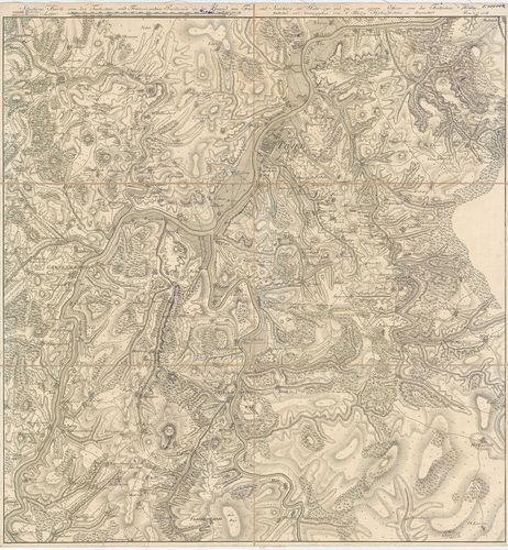
| Title | Situations Karte von den Teutschen und Französischen Positionen in der Gegend um Trier und Saarburg im Jahr 1793. und 1794. |
| Main title | Trier és Saarburg (No.) térsége 1793–93 részletes térképe. Megerősített helyek alaprajzban. Német és francia hadállások. |
13222. [Kembs és Schliengen közötti térség 1793. (Elszász.) Hadállá... [H IV a 239]
Institute and Museum of Military History •
H IV a (1700–1820)
•
H IV Újabbkori háborúk
•
H Háborúk
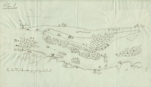
| Title | [Kembs és Schliengen közötti térség 1793. (Elszász.) Hadállások. |
13223. Nouvelle carte Pour l’inteligence des Operations Millitaires... [H IV a 256]
Institute and Museum of Military History •
H IV a (1700–1820)
•
H IV Újabbkori háborúk
•
H Háborúk
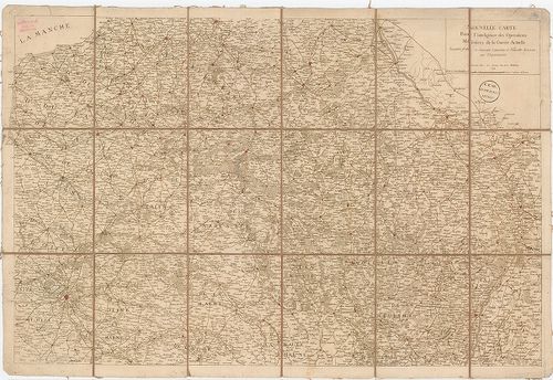
| Title | Nouvelle carte Pour l’inteligence des Operations Millitaires de la Guerre Actuelle… |
| Main title | A francia–osztrák és szövets. háború színtere 1794. Európa térképe Anvers – Troyes Abbeville – Mannheim között. Megerősített helyek, útvonalak. |
13224. Kriegs Theater der teutschen und franzoesischen Graenzlanden... [H IV a 258]
Institute and Museum of Military History •
H IV a (1700–1820)
•
H IV Újabbkori háborúk
•
H Háborúk
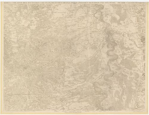
| Title | Kriegs Theater der teutschen und franzoesischen Graenzlanden zwischen dem Rhein und der Mosel im Jahr 1794–1799. Véste: B. F. Leizelt. |
| Main title | A német–francia határvidék hadszíntere a Rajna és a Mosel között 1794–1799-ben. Megerősített városok, települések. |
13225. Position bey Foron le Comte vom 23. bis… July 1794. [H IV a 281]
Institute and Museum of Military History •
H IV a (1700–1820)
•
H IV Újabbkori háborúk
•
H Háborúk
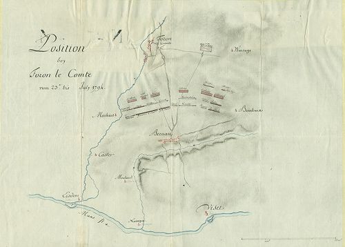
| Title | Position bey Foron le Comte vom 23. bis… July 1794. |
| Main title | Fouron le Comte-Bernau (Belg.) térsége 1794. Osztrák hadállások. Útvonalak. |
13226. Plan der feindlichen Attaque bey Büderich am 9-ten November ... [H IV a 302]
Institute and Museum of Military History •
H IV a (1700–1820)
•
H IV Újabbkori háborúk
•
H Háborúk
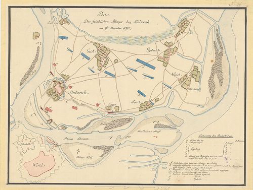
| Title | Plan der feindlichen Attaque bey Büderich am 9-ten November 1794. |
| Main title | Büderich vára és Wesel (No.) környéke 1794. Erődítések, sáncok alaprajzban. A Rajna-kanyar szigetei. Osztrák és francia hadállások. Útvonalak. |
13227. Plan de la bataille donnée le 20 Septembre entre l’armée com... [H IV a 305]
Institute and Museum of Military History •
H IV a (1700–1820)
•
H IV Újabbkori háborúk
•
H Háborúk
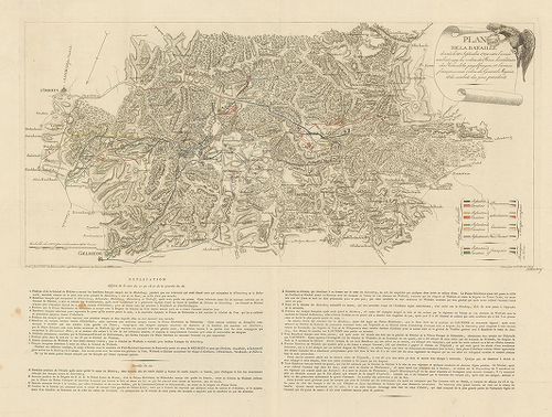
| Title | Plan de la bataille donnée le 20 Septembre entre l’armée combinée… et l’armée françoise… [chez Kayserslautern] |
| Main title | Kaiserslautern (No.) térségének részletes térképe az 1794. évi csata idején. A francia és a szövetséges haderők állásai, mozdulatai. Felvonulási irányok, útvonalak. Felragasztott szelvényen: helyzetváltozás. |
13228. [Landrecy és Cateau környékének térképe.] [H IV a 314]
Institute and Museum of Military History •
H IV a (1700–1820)
•
H IV Újabbkori háborúk
•
H Háborúk
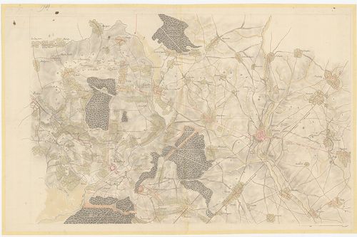
| Title | [Landrecy és Cateau környékének térképe.] |
| Main title | Landrecies erődei, la Cateau (Fr.) városa alaprajzban. Francia és szövetséges csapatok hadállásai, sáncai, felvonulási útjai. |
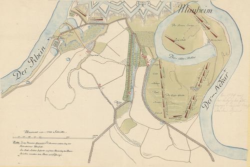
13229. Plan der, den 23-ten Decembris 1794 mit Capitulation an die ... [H IV a 327]
Institute and Museum of Military History •
H IV a (1700–1820)
•
H IV Újabbkori háborúk
•
H Háborúk
| Title | Plan der, den 23-ten Decembris 1794 mit Capitulation an die Franzosen Übergegebenen Rhein-Schanz… |
| Main title | Mannheim Rajnán-túli erődje és sáncai, Ludwigshafen (No.) alaprajzban. Összekötő utak. |
13230. Plan der Stadt und Vestung Mannheim Mit der umliegenden Gege... [H IV a 329]
Institute and Museum of Military History •
H IV a (1700–1820)
•
H IV Újabbkori háborúk
•
H Háborúk
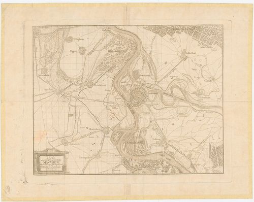
| Title | Plan der Stadt und Vestung Mannheim Mit der umliegenden Gegend… 1794. |
| Main title | Mannheim (No.) térségének térképe a Rajna és a Neckar összefolyásánál. A rajnai sáncok francia ostroma 1794. A város, erődítései és sáncai alaprajzban. Összekötő utak. |
13231. Plan der Position und Verschanzung der K. K. Truppen an der ... [H IV a 342]
Institute and Museum of Military History •
H IV a (1700–1820)
•
H IV Újabbkori háborúk
•
H Háborúk
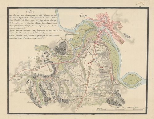
| Title | Plan der Position und Verschanzung der K. K. Truppen an der Chartreuse bey Lüttich… vom 26. July bis 17. Sept. 1794. |
| Main title | Chartreuse – Liege térsége (Belg.) 1794. Az osztrák csapatok állásai és sáncai. Lüttich városa és erődei alaprajzban. Útvonalak. |
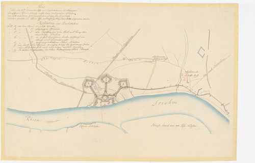
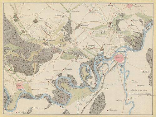
13232. [Mannheim (No.) környéke a Rajna mellett, 1794.] [H IV a 347]
Institute and Museum of Military History •
H IV a (1700–1820)
•
H IV Újabbkori háborúk
•
H Háborúk
| Title | [Mannheim (No.) környéke a Rajna mellett, 1794.] |
| Main title | Az erődítések egy része. A szövetséges csapatok táborhelyei a Neckar mellett. Útvonalak. |
13233. Position. Des unter Comando des Herrn General Major Baron vo... [H IV a 349]
Institute and Museum of Military History •
H IV a (1700–1820)
•
H IV Újabbkori háborúk
•
H Háborúk
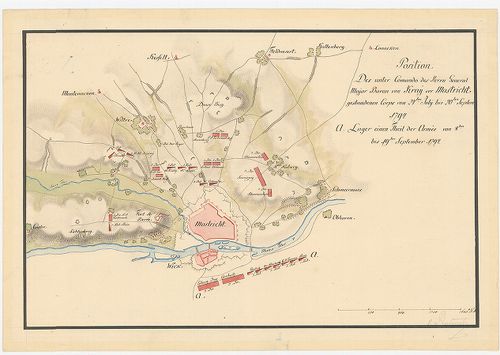
| Title | Position. Des unter Comando des Herrn General Major Baron von Kra˙ vor Mastricht gestandenen Corps von 24 ten July bis 20ten Septem 1794. |
| Main title | Maastricht (Holl.) környéke 1794-ben. Erődítések körvonalakban. Osztrák csapatok hadállásai. Útvonalak. |
13234. [Mannheim térsége: Schifferstadt–Speyer–Mannheim (No.) közöt... [H IV a 353]
Institute and Museum of Military History •
H IV a (1700–1820)
•
H IV Újabbkori háborúk
•
H Háborúk
| Title | [Mannheim térsége: Schifferstadt–Speyer–Mannheim (No.) között.] |
| Main title | Városok alaprajzban. Hadállások. Útvonalak. |
13235. Stellung der Kaiserl: Königl. und Koniglich Preussischen Cor... [H IV a 379]
Institute and Museum of Military History •
H IV a (1700–1820)
•
H IV Újabbkori háborúk
•
H Háborúk
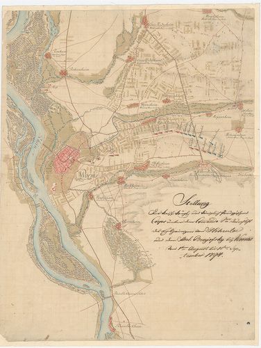
| Title | Stellung der Kaiserl: Königl. und Koniglich Preussischen Corps unter dem Comando… Hohenloe und … Benjofsky bey Worms vom 1-ten August bis 14-ten September 1794. |
| Main title | Worms (No.) térsége 1794. A város alaprajzban. Az osztrák és porosz csapatok hadállásai. Útvonalak. Átkelőhelyek a Rajnán. |
13236. Neue Topographische Carte der Lahn von Marburg bis zu ihrem ... [H IV a 404]
Institute and Museum of Military History •
H IV a (1700–1820)
•
H IV Újabbkori háborúk
•
H Háborúk
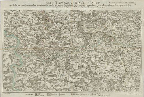
| Title | Neue Topographische Carte der Lahn von Marburg bis zu ihrem Einfluss in den Rhein… von 1795. und 1796. |
| Main title | A Lahn-folyó térsége Marburgtól a Rajnáig (No.) hadiesemények feltüntetésével 1795–96. Német és francia hadállások és hadmozdulatok, felvonulási utak. |
13237. Darstellung der Neutralitaets Linie welche von Preussen und ... [H IV a 407]
Institute and Museum of Military History •
H IV a (1700–1820)
•
H IV Újabbkori háborúk
•
H Háborúk
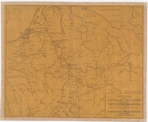
| Title | Darstellung der Neutralitaets Linie welche von Preussen und Frankreich in der am 17. May 1795 zu Basel unterzeichneten Convention verabredet worden. |
| Main title | Poroszország és Franciaország közötti semleges vonal. (Baseli egyezmény 1795. máj. 17.) |
13238. Laager der K. K. Lombardischen Armée bei Acqui von 15. Ma˙ b... [H IV a 422]
Institute and Museum of Military History •
H IV a (1700–1820)
•
H IV Újabbkori háborúk
•
H Háborúk
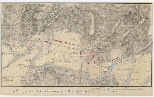
| Title | Laager der K. K. Lombardischen Armée bei Acqui von 15. Ma˙ bis 11 Jun˙ 1795. |
| Main title | Acqui (Ol.) és környéke. Az osztrák lombardiai hadsereg táborhelyei a Bormida-folyónál.(Osztrák–francia háború 1795.) |
13239. Laager der K. K. Lombardischen Armée auf dem Bricco di Sette... [H IV a 426/1]
Institute and Museum of Military History •
H IV a (1700–1820)
•
H IV Újabbkori háborúk
•
H Háborúk
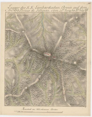
| Title | Laager der K. K. Lombardischen Armée auf dem Bricco di Settepan vom 25-ten Juny bis 13-ten July 1795. |
| Main title | Az osztrák lombardiai hadsereg táborhelyei és állásai a Settepani hegyvidéken (Ol.). (Osztrák–francia háború 1795.) |
13240. Laager der K. K. Lombrdischen Armée bei Carcare vom 14-ten b... [H IV a 427]
Institute and Museum of Military History •
H IV a (1700–1820)
•
H IV Újabbkori háborúk
•
H Háborúk
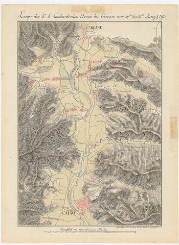
| Title | Laager der K. K. Lombrdischen Armée bei Carcare vom 14-ten bis 20-ten Juny 1795. |
| Main title | Carcare (Ol.) és környéke. Az osztrák lombardiai hadsereg táborhelyei a Bormida-folyónál (Osztrák–francia háború 1795.) |