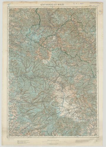
6521. Schubplan des kais. könig. Gensdarmerie Regiments N 7. [B IX c 1443]
Institute and Museum of Military History •
B IX c
•
B IX Ausztria–Magyarország
•
B I–XV. Európa
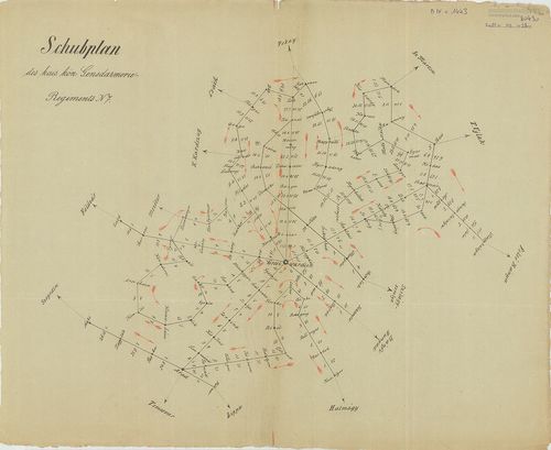
| Title | Schubplan des kais. könig. Gensdarmerie Regiments N 7. |
| Main title | A Nagyváradról kiinduló menetvonalak távolságának térképe a menetidő bejelölésével a 7. csendőrezred működési területén. (1856-1867.) |
6522. Herzogtum Salzburg und das Salzkammergut mit den Grenzgebiet... [B IX c 1444]
Institute and Museum of Military History •
B IX c
•
B IX Ausztria–Magyarország
•
B I–XV. Európa
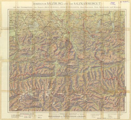
| Title | Herzogtum Salzburg und das Salzkammergut mit den Grenzgebieten von Bayern (Reichenhall – Berchtesgaden), Ober-Österreich Tirol, Steiermark und Kärnten. |
| Main title | Salzburg és környékének térképe. |
6523. Magyarország. [B IX c 1445]
Institute and Museum of Military History •
B IX c
•
B IX Ausztria–Magyarország
•
B I–XV. Európa
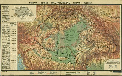
| Title | Magyarország. |
| Main title | A magyarság területeinek elhelyezkedése és táblázat a trianoni szerződés következményiről. |
6524. Magyar korona országai kézi abrosza. [B IX c 1446]
Institute and Museum of Military History •
B IX c
•
B IX Ausztria–Magyarország
•
B I–XV. Európa
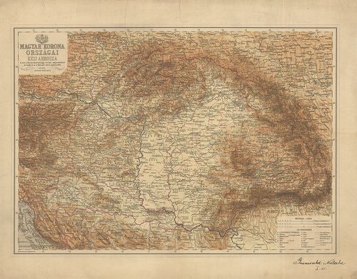
| Title | Magyar korona országai kézi abrosza. |
6525. Die Oesterreich.-Ungarischen Eisenbahnen der Gegenwart und Z... [B IX c 1447]
Institute and Museum of Military History •
B IX c
•
B IX Ausztria–Magyarország
•
B I–XV. Európa
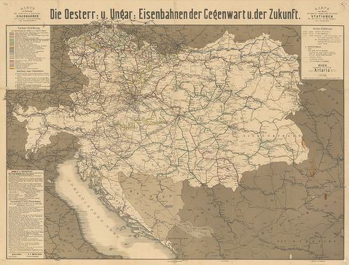
| Title | Die Oesterreich.-Ungarischen Eisenbahnen der Gegenwart und Zukunft. |
| Main title | Az Osztrák-Magyar Monarchia vasúttérképe a jelen- és a jővő időben. |
6526. G. Freytags neue Verkehrskarte von Österreich-Ungarn. [B IX c 1448]
Institute and Museum of Military History •
B IX c
•
B IX Ausztria–Magyarország
•
B I–XV. Európa
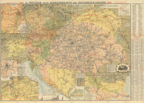
| Title | G. Freytags neue Verkehrskarte von Österreich-Ungarn. |
| Main title | Az Osztrák-Magyar Monarchia új közelekedési térképe 1901-ből. |
6527. Velagen u.Klasings Neuer Volk- und Familien -Atlas. Probekar... [B IX c 1449]
Institute and Museum of Military History •
B IX c
•
B IX Ausztria–Magyarország
•
B I–XV. Európa
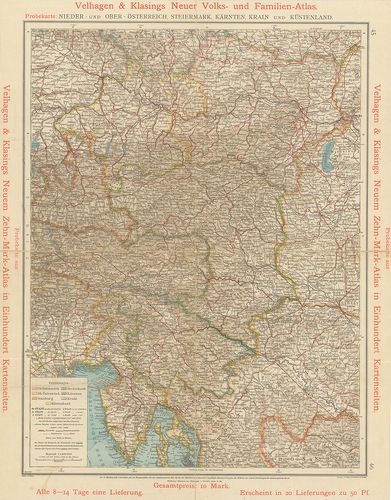
| Title | Velagen u.Klasings Neuer Volk- und Familien -Atlas. Probekarte: Nieder- und ober- Öterreich, Steiermark, Kaerten, Krain und Küstenland. |
| Main title | A Velagen u. Klasings Atlasz próbatérképe: Alsó- és Felső Ausztria, Stájerország, Karintia, Krajna és a magy. tengerpart. |
6528. Magyarország Egyházmegyéi. [B IX c 1450]
Institute and Museum of Military History •
B IX c
•
B IX Ausztria–Magyarország
•
B I–XV. Európa
| Title | Magyarország Egyházmegyéi. |
6529. A Debrecen-Nyíregyházi Egyházmegye térképe. [B IX c 1451]
Institute and Museum of Military History •
B IX c
•
B IX Ausztria–Magyarország
•
B I–XV. Európa
| Title | A Debrecen-Nyíregyházi Egyházmegye térképe. |
6530. Az Esztergom-Budapesti Főegyházmegye térképe. [B IX c 1452]
Institute and Museum of Military History •
B IX c
•
B IX Ausztria–Magyarország
•
B I–XV. Európa
| Title | Az Esztergom-Budapesti Főegyházmegye térképe. |
6531. A Veszprémi Főegyházmegye térképe. [B IX c 1453]
Institute and Museum of Military History •
B IX c
•
B IX Ausztria–Magyarország
•
B I–XV. Európa
| Title | A Veszprémi Főegyházmegye térképe. |
6532. A Kalocsa-Kecskeméti Főegyházmegye térképe. [B IX c 1454]
Institute and Museum of Military History •
B IX c
•
B IX Ausztria–Magyarország
•
B I–XV. Európa
| Title | A Kalocsa-Kecskeméti Főegyházmegye térképe. |
6533. A Magyaroszági Református Egyház térképe. [B IX c 1455]
Institute and Museum of Military History •
B IX c
•
B IX Ausztria–Magyarország
•
B I–XV. Európa
| Title | A Magyaroszági Református Egyház térképe. |
6534. Gränz-Karte des Trentschiner Comitats mit den angrenzenden P... [B IX c 1456]
Institute and Museum of Military History •
B IX c
•
B IX Ausztria–Magyarország
•
B I–XV. Európa
| Title | Gränz-Karte des Trentschiner Comitats mit den angrenzenden Provinzen. |
| Main title | Trencsén megye és a környező területek határtérképe. |
6535. Gränz-Karte des Arvenser Comitates mit dem angränzenden Thei... [B IX c 1457]
Institute and Museum of Military History •
B IX c
•
B IX Ausztria–Magyarország
•
B I–XV. Európa
| Title | Gränz-Karte des Arvenser Comitates mit dem angränzenden Theile von Galizien. |
| Main title | Árva megye és a környező területek határtérképe. |
6536. Commercielle Special-Karte der Österr-Ungar Monarchie. [B IX c 1458]
Institute and Museum of Military History •
B IX c
•
B IX Ausztria–Magyarország
•
B I–XV. Európa
| Title | Commercielle Special-Karte der Österr-Ungar Monarchie. |
6537. Karte von Kärnten. [B IX c 1459]
Institute and Museum of Military History •
B IX c
•
B IX Ausztria–Magyarország
•
B I–XV. Európa
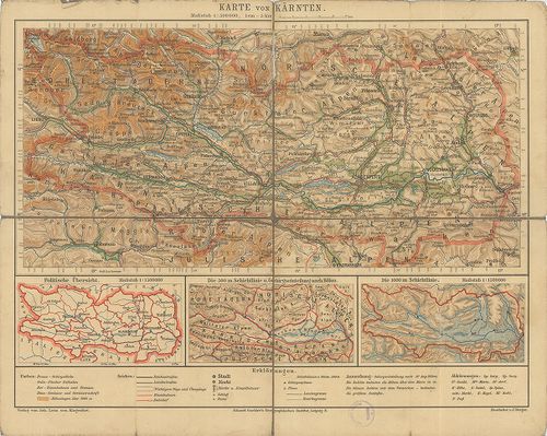
| Title | Karte von Kärnten. |
| Main title | Karintia térképe. |
6538. [A bukaresti béke határvonala.] [B IX c 1460]
Institute and Museum of Military History •
B IX c
•
B IX Ausztria–Magyarország
•
B I–XV. Európa
| Title | [A bukaresti béke határvonala.] |
| Main title | A bejárt de ki nem tűzött román-magyar határ közelítő nyomvonala. |
6539. Plan von der Landt-Granitz zwischen dem Bannat und der Walac... [B IX c 1461]
Institute and Museum of Military History •
B IX c
•
B IX Ausztria–Magyarország
•
B I–XV. Európa
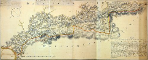
| Title | Plan von der Landt-Granitz zwischen dem Bannat und der Walachey. |
| Main title | A Bánság és Havasalföld határtérképe. |
6540. Mappa vorstellendt die Granitz welcher gestallten nach Inhal... [B IX c 1463]
Institute and Museum of Military History •
B IX c
•
B IX Ausztria–Magyarország
•
B I–XV. Európa
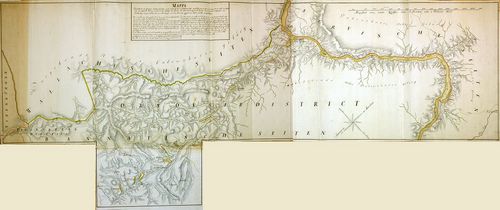
| Title | Mappa vorstellendt die Granitz welcher gestallten nach Inhalt des letzt zu Belgrad 1739 geschlossenen Frieden in Antrag ist ... von Porec an bis zu den Emfluss der Cserna ... etc. |
| Main title | Az 1739-es belgrádi béke után meghatározott határ Porec és a Cserna folyó között. |