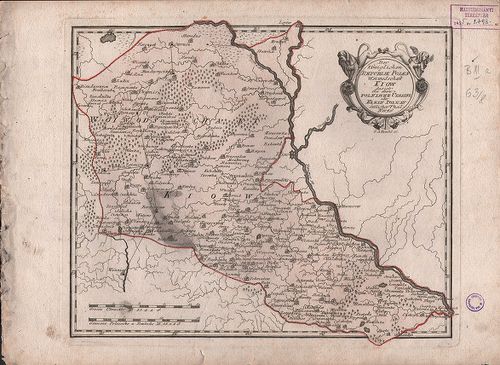
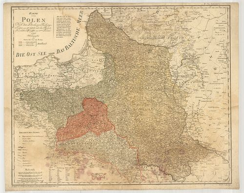
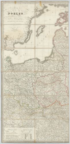
6641. Mappa Geographica Ploniae… [B XI a 62/1]
Institute and Museum of Military History •
B XI a
•
B XI Oroszország
•
B I–XV. Európa
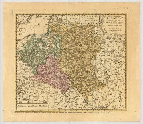
| Title | Mappa Geographica Ploniae… |
| Main title | Lengyelország földrajzi térképe 1750 körül. |
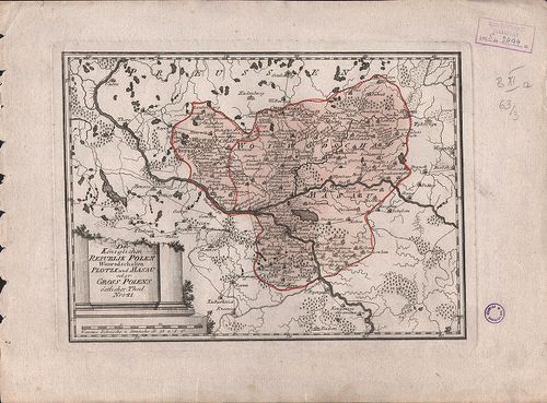
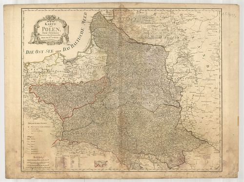
6642. Die Königliche Republik Polen mit Grossherzoghtum Lithauen. ... [B XI a 63]
Institute and Museum of Military History •
B XI a
•
B XI Oroszország
•
B I–XV. Európa
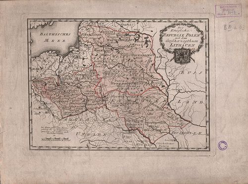
| Title | Die Königliche Republik Polen mit Grossherzoghtum Lithauen. Nro. 38. |
| Main title | Lengyelország és a Litván nagyhercegség térképe 1789-ben. |
6643. Der Königlichen Republik Polen Woidwedschaften Posen, Kalisz... [B XI a 63/1]
Institute and Museum of Military History •
B XI a
•
B XI Oroszország
•
B I–XV. Európa
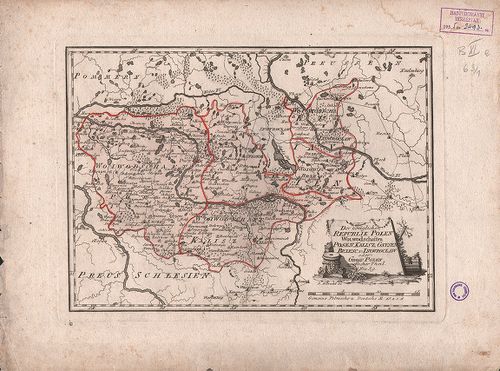
| Title | Der Königlichen Republik Polen Woidwedschaften Posen, Kalisz Gmesen, Brzese und Inowroclaw. No. 39. |
| Main title | Lengyelország vajdaságai 1789-ben. |
6644. Der Königlichen Republik Polen Woiwodschaften Sieradz, Lents... [B XI a 63/2]
Institute and Museum of Military History •
B XI a
•
B XI Oroszország
•
B I–XV. Európa
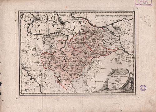
| Title | Der Königlichen Republik Polen Woiwodschaften Sieradz, Lentschitz und Rawa. Nro. 40. |
| Main title | Lengyelország vajdaságai 1789-ben. |
6645. Der Königlichen Republik Polen Woiwodschaften Plotzk und Mas... [B XI a 63/3]
Institute and Museum of Military History •
B XI a
•
B XI Oroszország
•
B I–XV. Európa
| Title | Der Königlichen Republik Polen Woiwodschaften Plotzk und Masau. Nro. 41. |
| Main title | Lengyelország vajdaságai 1789-ben. |
6646. Der Königlichen Republik Polen Woiwodschaften Krakow und San... [B XI a 63/4]
Institute and Museum of Military History •
B XI a
•
B XI Oroszország
•
B I–XV. Európa
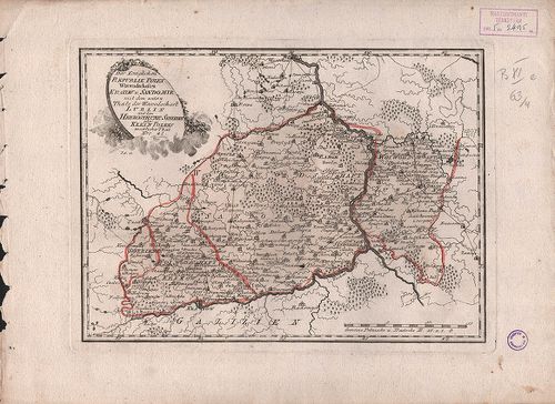
| Title | Der Königlichen Republik Polen Woiwodschaften Krakow und Sandomir mit… Lublin. Nro. 42. |
| Main title | Lengyelország vajdaságai 1789-ben. |
6647. Der Königlichen Republik Polen Woiwodschaft Podlachien mit… ... [B XI a 63/5]
Institute and Museum of Military History •
B XI a
•
B XI Oroszország
•
B I–XV. Európa
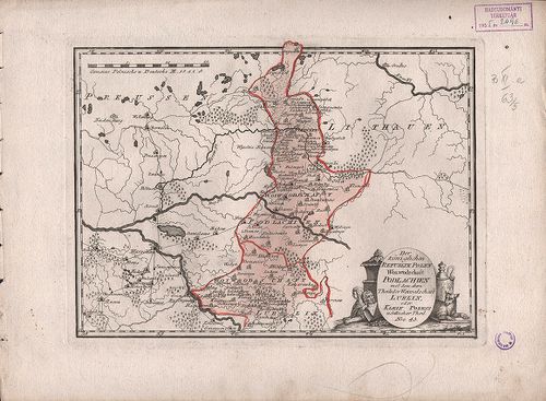
| Title | Der Königlichen Republik Polen Woiwodschaft Podlachien mit… Lublin. Nro. 43. |
| Main title | Lengyelország vajdaságai 1789-ben. |
6648. Der Königlichen Republik Polen. Woiwodschaften Chelm und Wol... [B XI a 63/6]
Institute and Museum of Military History •
B XI a
•
B XI Oroszország
•
B I–XV. Európa
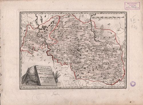
| Title | Der Königlichen Republik Polen. Woiwodschaften Chelm und Wolhynien. Nro. 44. |
| Main title | Lengyelország vajdaságai 1789-ben. |
6649. Der Königlichen Republik Polen. Woiwodschaft Kiew. Nro. 46. [B XI a 63/8]
Institute and Museum of Military History •
B XI a
•
B XI Oroszország
•
B I–XV. Európa
| Title | Der Königlichen Republik Polen. Woiwodschaft Kiew. Nro. 46. |
| Main title | Lengyelország Kijevi vajdasága 1789-ben. |
6650. Carte de la Pologne… [B XI a 64]
Institute and Museum of Military History •
B XI a
•
B XI Oroszország
•
B I–XV. Európa
| Title | Carte de la Pologne… |
| Main title | Mt.: Plan de Varsovie (Varsó). |
| Subject | Lengyelország térképe 1772-ben tartományi beosztással. |
6651. Karte von Gross Polen… [B XI a 65]
Institute and Museum of Military History •
B XI a
•
B XI Oroszország
•
B I–XV. Európa
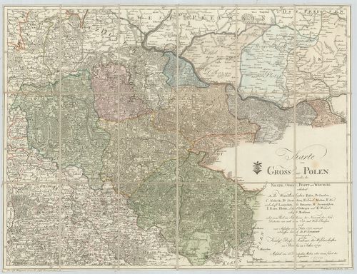
| Title | Karte von Gross Polen… |
| Main title | Lengyelország térképe 1791-ben. |
6652. Polen in die dermaligen Besitzungen eingetheilt. [B XI a 66]
Institute and Museum of Military History •
B XI a
•
B XI Oroszország
•
B I–XV. Európa
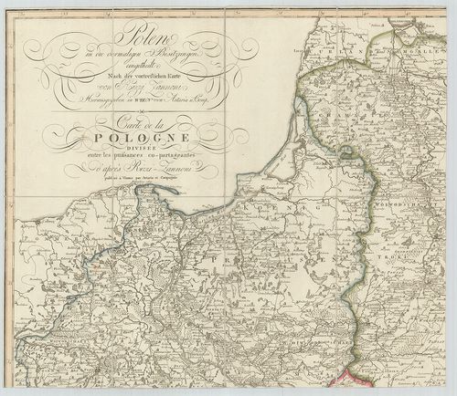
| Title | Polen in die dermaligen Besitzungen eingetheilt. |
| Main title | Lengyelország általános térképe a 2. felosztás után 1807-ben a vajdaságok feltüntetésével. |
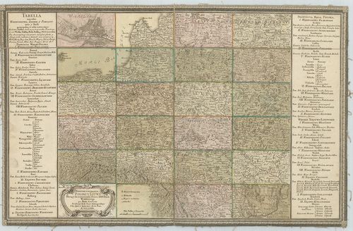
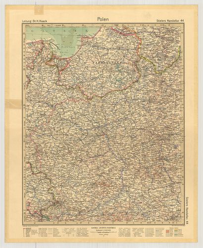
6653. Polen. (Rzeczpospolita Polska) Flemmings Generalkarte. Nr. 3... [B XI a 68]
Institute and Museum of Military History •
B XI a
•
B XI Oroszország
•
B I–XV. Európa
| Title | Polen. (Rzeczpospolita Polska) Flemmings Generalkarte. Nr. 33. |
| Main title | 11 mt.: 1. (5) Reisewege von und nach Polen. (Vasút, repülő-hajózási útvonalak Európa területén.) 2. (6) Polen. (Lengyelország hegyvízrajzi térképe.) 3. (7) Warschau und Umgebung (Warszawa és környéke.) 4. (9) Das oberschlesische Kohlen- und Industriegebiet (Felső-Szilézia kőszén és iparvidéke.) 5. Oberschles. Steinkohlengebiet. (Felső-Szilézia kőszénvidéke.) 6. (10) Niederschläge (Az évi csapadék.) 7. (11) Január-Isothermen (Januári izotermák.) 8. (12) Juli-Isothermen (Júliusi izotermák.) 9. (13) Zur Geschichte Polens I. (Lengyelország 992–1025.) 10. (14) Zur Geschichte Polens II. (Lengyelország 1586.) 11. (15) Zur Geschichte Polen III. (Lengyelország 1772., 1793., 1795. évi felosztása.) |
| Subject | Lengyelország térképe 1922-ben. |
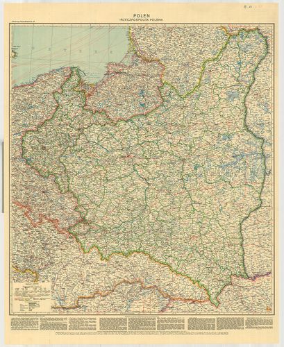
6654. Polen. [B XI a 69]
Institute and Museum of Military History •
B XI a
•
B XI Oroszország
•
B I–XV. Európa
| Title | Polen. |
| Main title | Lengyelország térképe 1931-ben. |
6655. Mapa Polski. [B XI a 70]
Institute and Museum of Military History •
B XI a
•
B XI Oroszország
•
B I–XV. Európa
| Title | Mapa Polski. |
| Main title | Mt.: Średnia gęstość zaludnienia w powiatach. |
| Subject | Lengyelország közigazgatási térképe. |
6656. Polska. Mapa administracyjna. [B XI a 71]
Institute and Museum of Military History •
B XI a
•
B XI Oroszország
•
B I–XV. Európa
| Title | Polska. Mapa administracyjna. |
| Main title | Mt.: Okręg Katowicki. (Katowice kerület.) |
| Subject | Lengyelország közigazgatási térképe. |
6657. Karte von Polen… 1795. [B XI a 73]
Institute and Museum of Military History •
B XI a
•
B XI Oroszország
•
B I–XV. Európa
| Title | Karte von Polen… 1795. |
| Main title | Lengyelország térképe 1795-ben. |
6658. Karte von Polen. [B XI a 73/1]
Institute and Museum of Military History •
B XI a
•
B XI Oroszország
•
B I–XV. Európa
| Title | Karte von Polen. |
| Main title | Lengyelország térképe 1796-ban. |
6659. Carte von Polen… der angrenzenden Laender. – Carte Générale ... [B XI a 74]
Institute and Museum of Military History •
B XI a
•
B XI Oroszország
•
B I–XV. Európa
| Title | Carte von Polen… der angrenzenden Laender. – Carte Générale et détaillée de la Pologne… |
| Main title | Lengyelország térképe 1828-ban. |
6660. Karte von Herzogthum Warschau… in IV. Section. [B XI a 74/1]
Institute and Museum of Military History •
B XI a
•
B XI Oroszország
•
B I–XV. Európa
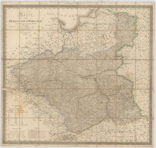
| Title | Karte von Herzogthum Warschau… in IV. Section. |
| Main title | A Varsói Hercegség és a szomszédos területek térképe 1812-ben. |