6701. Karta Ekaterinoszlavszkoj Gubernii. [B XI a 128]
Institute and Museum of Military History •
B XI a
•
B XI Oroszország
•
B I–XV. Európa
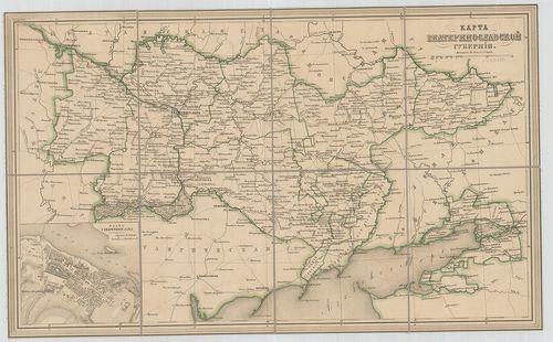
| Title | Karta Ekaterinoszlavszkoj Gubernii. |
| Main title | Mt.: Plan G.[oroda] Ekaterinoszlava. (Jekatyerinoszláv város alaprajza.) |
| Subject | A Jekatyerinoszlávi (Dnyepropetrovsz) Kormányzóság térképe 1820 körül. |
6702. Übersichtskarte von Ostpreussen, Kurland und den angrenzende... [B XI a 129]
Institute and Museum of Military History •
B XI a
•
B XI Oroszország
•
B I–XV. Európa
| Title | Übersichtskarte von Ostpreussen, Kurland und den angrenzenden Gebieten. |
| Main title | Kelet-Poroszország, Lettország és Litvánia áttekintő térképe a vasútvonalak feltüntetésével. |
6703. Generaljnaja Karta Kievszkoj Gubernii. – Mappa Generalna Gub... [B XI a 130]
Institute and Museum of Military History •
B XI a
•
B XI Oroszország
•
B I–XV. Európa
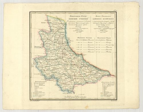
| Title | Generaljnaja Karta Kievszkoj Gubernii. – Mappa Generalna Gubernii Kijowskiey. No. 15. |
| Main title | A Kijevi Kormányzóság általános térképe 1821-ben. |
6704. Karta Kievszkoj gubernii. [B XI a 131]
Institute and Museum of Military History •
B XI a
•
B XI Oroszország
•
B I–XV. Európa
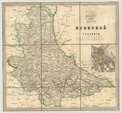
| Title | Karta Kievszkoj gubernii. |
| Main title | Mt.: Plan g[oroda] Kieva (Kijev város alaprajza.) |
| Subject | A Kijevi Kormányzóság az 1800-as évek elején. |
6705. Ducatus Curlandiae… Le duché de Courlande. – Curlandiae [et]... [B XI a 132]
Institute and Museum of Military History •
B XI a
•
B XI Oroszország
•
B I–XV. Európa
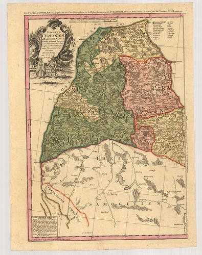
| Title | Ducatus Curlandiae… Le duché de Courlande. – Curlandiae [et] Semgalliae… Le duche de Semgalle. |
| Main title | A Kurlandiai (Kurzeme) és Zemgalei hercegség térképe 1747-ben. |
6706. Ducatuum Livoniae et Curlandie… [B XI a 133]
Institute and Museum of Military History •
B XI a
•
B XI Oroszország
•
B I–XV. Európa
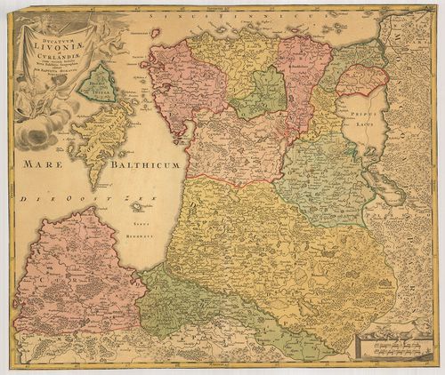
| Title | Ducatuum Livoniae et Curlandie… |
| Main title | A Livóniai (Vidzene) és a Kurlandi (Kurzeme, Lettország) hercegség térképe az 1700-as évek elején. |
6707. Karte von Liefland Statthalt. Riga. – [Atlas von Lievland od... [B XI a 134]
Institute and Museum of Military History •
B XI a
•
B XI Oroszország
•
B I–XV. Európa
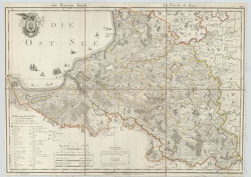
| Title | Karte von Liefland Statthalt. Riga. – [Atlas von Lievland oder vom … Liefland Enstland und der Provinz, Oesel.] |
| Main title | Észtország és Lettország kerületeinek térképe 1791–1798-ig. |
6708. A Keleti-tenger partvidéke. [B XI a 135]
Institute and Museum of Military History •
B XI a
•
B XI Oroszország
•
B I–XV. Európa
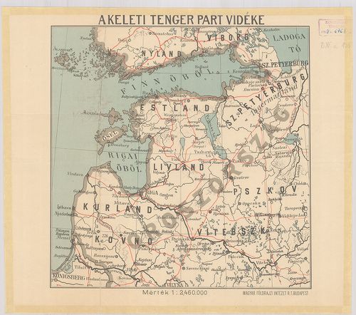
| Title | A Keleti-tenger partvidéke. |
6709. G. Freytags karte der Ostsee-Provinzen. Kurland, Livland, Es... [B XI a 136]
Institute and Museum of Military History •
B XI a
•
B XI Oroszország
•
B I–XV. Európa
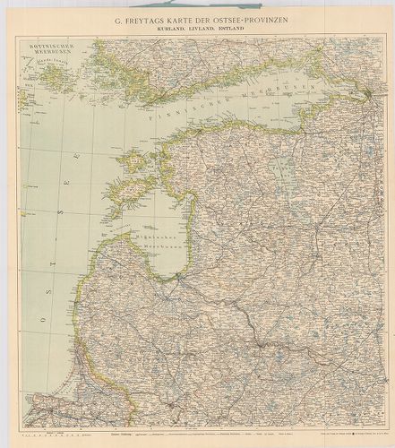
| Title | G. Freytags karte der Ostsee-Provinzen. Kurland, Livland, Estland. |
| Main title | A Keleti-tenger tartományai: Lettország, Litvánia, Észtország közigazgatási térképe 1910 körül. |
6710. Gereraljnaja Kartá Minszkoj Gubernii. Mappa Generalna Gubern... [B XI a 137]
Institute and Museum of Military History •
B XI a
•
B XI Oroszország
•
B I–XV. Európa
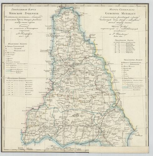
| Title | Gereraljnaja Kartá Minszkoj Gubernii. Mappa Generalna Gubernii Minskiey. |
| Main title | A Minszki Kormányzóság részletes térképe 1821-ben. |
6711. Karta Minszkoj Gubernii. [B XI a 138]
Institute and Museum of Military History •
B XI a
•
B XI Oroszország
•
B I–XV. Európa
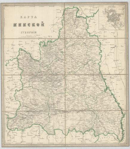
| Title | Karta Minszkoj Gubernii. |
| Main title | Mt.: Plan G[oroda] Minszka. (Minszk.) |
| Subject | A Minszki Kormányzóság térképe. |
6712. Generalnaja Karta Mogilevszkoj Gubernii. – Mappa Generalna G... [B XI a 139]
Institute and Museum of Military History •
B XI a
•
B XI Oroszország
•
B I–XV. Európa
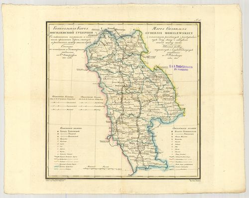
| Title | Generalnaja Karta Mogilevszkoj Gubernii. – Mappa Generalna Gubernii Mohilewskiey. No. 13. |
| Main title | A Mogiljovi Kormányzóság térképe 1821-ben. |
6713. Karta Petrokovszkoj Gubernii. [B XI a 141/4]
Institute and Museum of Military History •
B XI a
•
B XI Oroszország
•
B I–XV. Európa
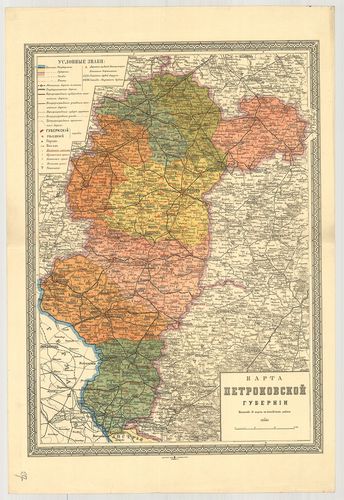
| Title | Karta Petrokovszkoj Gubernii. |
| Main title | A Petrokovi (Pietrków Trybunalski) Kormányzóság térképe 1900 körül. |
6714. Karta Podolszkoj Gubernii. [B XI a 144]
Institute and Museum of Military History •
B XI a
•
B XI Oroszország
•
B I–XV. Európa
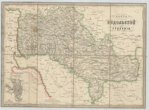
| Title | Karta Podolszkoj Gubernii. |
| Main title | Mt.: Plan G. Kamenec Podolszka. (Kamenyec Podolszki) |
| Subject | A Podolszki kormányzóság térképe. |
6715. Karta Radomszkoj Gubernii. [B XI a 145/12]
Institute and Museum of Military History •
B XI a
•
B XI Oroszország
•
B I–XV. Európa
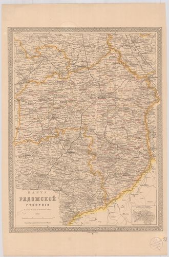
| Title | Karta Radomszkoj Gubernii. |
| Main title | Mt.: Plan G. Radoma (Radom). |
| Subject | A Radomi Kormányzóság térképe 1900 körül. |
6716. [Radom-Lublin környékének térképe..] [B XI a 145/13]
Institute and Museum of Military History •
B XI a
•
B XI Oroszország
•
B I–XV. Európa
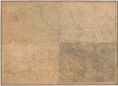
| Title | [Radom-Lublin környékének térképe..] |
6717. Ingermanlandiae seu Ingriae novissima Tabula luci tradita. [B XI a 147]
Institute and Museum of Military History •
B XI a
•
B XI Oroszország
•
B I–XV. Európa
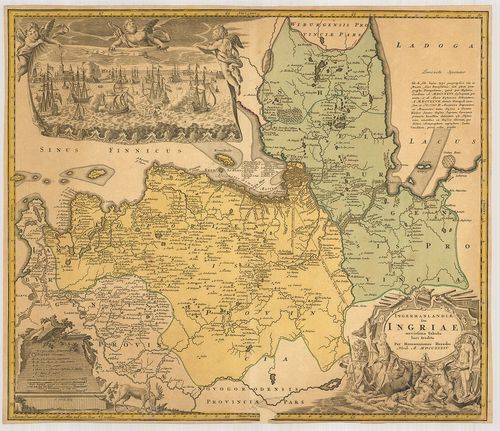
| Title | Ingermanlandiae seu Ingriae novissima Tabula luci tradita. |
| Main title | Tengeri csata. St. Petersburgnál. (Sz. Pétervár-Leningrád). Ingria térképe 1734-ben. |
6718. Geographica Nova ex Oriente gratiosissima duabus tabulis… Ma... [B XI a 148]
Institute and Museum of Military History •
B XI a
•
B XI Oroszország
•
B I–XV. Európa
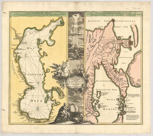
| Title | Geographica Nova ex Oriente gratiosissima duabus tabulis… Mare Caspium, altera Kamtzadalian seu Terram Jedzo… |
| Main title | 2 térk.: 1. Das Caspische Meer (A Kaszpi-tenger). 2. Das Land Kamtzadalie sonst Jedso.A Kaszpi-tenger és a Kamcsatka-fsz. térképe 1700 körül. |
6719. Nova et accurata Turcarum et Tartaricarum Moldaviae et Walla... [B XI a 152]
Institute and Museum of Military History •
B XI a
•
B XI Oroszország
•
B I–XV. Európa
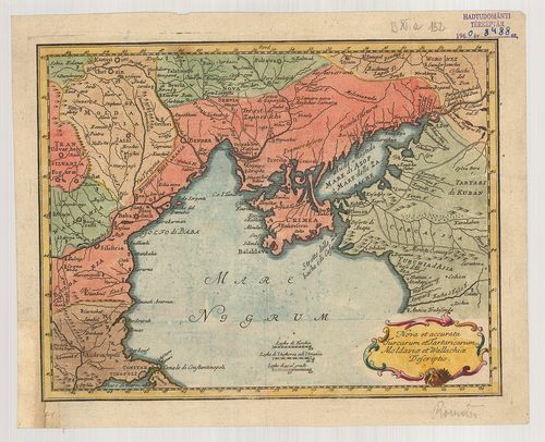
| Title | Nova et accurata Turcarum et Tartaricarum Moldaviae et Wallachiae Descriptio. |
| Main title | A Fekete-tenger északi részének környéke Moldava és Vallachia térképe a 18. században. |
6720. Carte de la Crimée. [B XI a 153]
Institute and Museum of Military History •
B XI a
•
B XI Oroszország
•
B I–XV. Európa
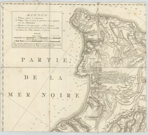
| Title | Carte de la Crimée. |
| Main title | A Krím-félsziget térképe 1787-ben. |