3861. Carta topographica ciuitatis fortalityque Varadini (Oradea) ... [B IX a 483/9]
Institute and Museum of Military History •
B IX a
•
B IX Ausztria–Magyarország
•
B I–XV. Európa
| Title | Carta topographica ciuitatis fortalityque Varadini (Oradea) magni eorumque circumiacentium. |
| Main title | Bihar megye (Erdély) nagy részének térképe a 17. században. |
3862. a) Tiszántúl D-i részének térképe. (Debrecen–Szeged–Temesvár... [B IX a 483/10]
Institute and Museum of Military History •
B IX a
•
B IX Ausztria–Magyarország
•
B I–XV. Európa
| Title | a) Tiszántúl D-i részének térképe. (Debrecen–Szeged–Temesvár, Timisoara, között. |
| Main title | b) Nagyvárad környéke. |
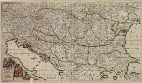
3863. Hungaria Regnum. [B IX a 484]
Institute and Museum of Military History •
B IX a
•
B IX Ausztria–Magyarország
•
B I–XV. Európa
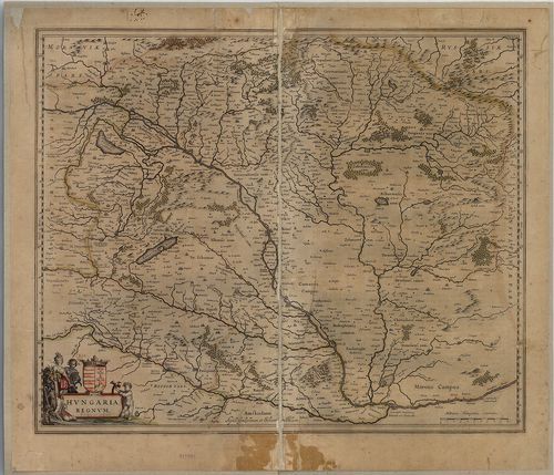
| Title | Hungaria Regnum. |
| Main title | Magyarország térképe 1640 körül. |
3864. Totius Regni Hungariae et adjacentium Regionum Tabula / A[nn... [B IX a 485]
Institute and Museum of Military History •
B IX a
•
B IX Ausztria–Magyarország
•
B I–XV. Európa
| Title | Totius Regni Hungariae et adjacentium Regionum Tabula / A[nno] 1687 ob res bellicas inter Christianos et Turcas exacte correcta ac innumeris locis aucta per… |
| Main title | A Magyar Királyság és a szomszédos területek térképe 1687 körül. |
3865. Transylvania / Sibenburgen. [B IX a 486]
Institute and Museum of Military History •
B IX a
•
B IX Ausztria–Magyarország
•
B I–XV. Európa
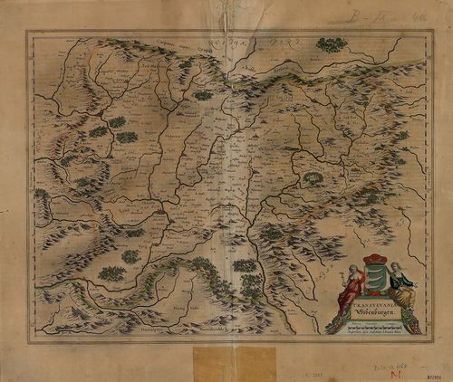
| Title | Transylvania / Sibenburgen. |
| Main title | Erdély térképe Mercator nyomán 1635 körül. |
3866. Austria Archiducatus. [B IX a 487]
Institute and Museum of Military History •
B IX a
•
B IX Ausztria–Magyarország
•
B I–XV. Európa

| Title | Austria Archiducatus. |
| Main title | Ausztria térképe Lazius 16. századi térképe alapján. |
3867. Vermehrte und verbesserte Landkarten des Königreichs Ungarn ... [B IX a 487/1]
Institute and Museum of Military History •
B IX a
•
B IX Ausztria–Magyarország
•
B I–XV. Európa
| Title | Vermehrte und verbesserte Landkarten des Königreichs Ungarn und deren andern angrentzenden Königreiche Fürstenthumen und Landschafften samt denen Grentz, Posten, … Ertzhaus Oesterreich von dem Adriatischen Meer an bis in Siebenbürgen vor Verstungen und Plätze gegen dem Erbfeind zu Nutz der gantzen Christenheit… |
| Main title | A Magyar Királyság,, Ausztria, Horvátország és Erdély, térképe 1684-ben. |
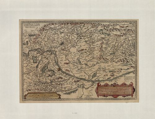
3868. Hungariae Descriptio. Wolfgango Lazio auct. [B IX a 487/1-1]
Institute and Museum of Military History •
B IX a
•
B IX Ausztria–Magyarország
•
B I–XV. Európa
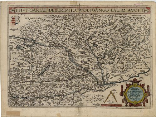
| Title | Hungariae Descriptio. Wolfgango Lazio auct. |
| Main title | Magyarország térképe 1575 körül. |
3869. Mappa della, Transilvania, e Provintie contique nella quales... [B IX a 487/15]
Institute and Museum of Military History •
B IX a
•
B IX Ausztria–Magyarország
•
B I–XV. Európa
| Title | Mappa della, Transilvania, e Provintie contique nella qualesivedano li Consini dell’ Ongaria eli Campam fatti dall; Arpate Cesaree in quelte ultime guere. |
| Main title | A térk. Ny-i és K-i szélén 16 város, ill. vár alapr. és látképe. 1. Veduta d’Oriente de Schesburg. [Segesvár, Sighişoara látképe K-ről.] 2. Veduta da mezzo giorno di Deva. [Déva, Deva) látképe dél felöl.] 3. Veduta da Ponente di G˙rg˙n˙. [Görgény vár látképe Ny-ról.] 4. Pianta di Kronstadt. [Brassó-i vár, Braşow) alapr.] 5. Pianta di Udvarhell. [Székelyudvarhely, Odorheiu, alapr.] 6. Pianta di Fogaras. [Făgăras, vár alapr.] 7. Pianta di Klausemburg. [Kolozsvár, Cluj, alapr.] 8. Hermannstadt Citta Capitale della Transilvania. [Nagyszeben, Sibiu, Erdély fővárosa, alapr.] 9. Veduta da ponente della Citta di Hermannstadt. [Nagyszeben, Sibiu,) látképe Ny-ról.] 10. Disegno di Nissa. [Niš vár) alapr.] 11. Pianta di Belgrado. [Beograd, alapr.] 12. Pianta di Bistrizza. [Besztercei vár, Bistriţa alapr.] 13. Pianta di Medies. [Medgyesi vár, Medias alapr.] 14. Pianta di Samoshuyvar. [Szamosújvár, Gherla alapr.] 15. Veduta damezo giorno Samoshuyvar. [Szamosujvár, Gherla) látképe.] 16. Peter Varadino… [Pétervárad, Petrovaradin alapr.] |
| Subject | Erdély és a vele határos tartományok térképe 1699-ben. |
3870. Tabula Nova Inclyti Regni Hungariae juxta nonnullas Observat... [B IX a 487/29]
Institute and Museum of Military History •
B IX a
•
B IX Ausztria–Magyarország
•
B I–XV. Európa
| Title | Tabula Nova Inclyti Regni Hungariae juxta nonnullas Observationes. |
| Main title | Magyarország térképe 1753-ban. |
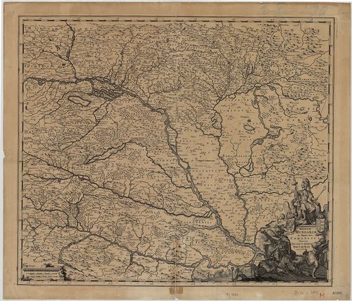
3871. Hungaria Regnum. [B IX a 488/1]
Institute and Museum of Military History •
B IX a
•
B IX Ausztria–Magyarország
•
B I–XV. Európa
| Title | Hungaria Regnum. |
| Main title | Magyarország térképe a 17. században. |
3872. Regnum Hungariae in Omnes suos Comitatus Accurate Divisum… [B IX a 489]
Institute and Museum of Military History •
B IX a
•
B IX Ausztria–Magyarország
•
B I–XV. Európa
| Title | Regnum Hungariae in Omnes suos Comitatus Accurate Divisum… |
| Main title | A Magyar Királyság általános térképe a XVII. század végén. |
3873. [A Duna–Tisza–Maros közének térképe.] [B IX a 489/1]
Institute and Museum of Military History •
B IX a
•
B IX Ausztria–Magyarország
•
B I–XV. Európa
| Title | [A Duna–Tisza–Maros közének térképe.] |
3874. Regni Hungariae et Regionum, quae ei quondam fuere unitae, u... [B IX a 490]
Institute and Museum of Military History •
B IX a
•
B IX Ausztria–Magyarország
•
B I–XV. Európa
| Title | Regni Hungariae et Regionum, quae ei quondam fuere unitae, ut Transilvaniae, Valachiae, Moldaviae, Serviae, Romaniae, Bulgariae, Bessarábiae, Croatiae, Bosniae, Dalmatiae, Sclavoniae, Morlachiae, Ragusanae Republicae Maximaequ Partis Danubii Fluminis. |
| Main title | A Magyar Királyság és a környező államok (Duna menti országok) térképe 1688-ban. |
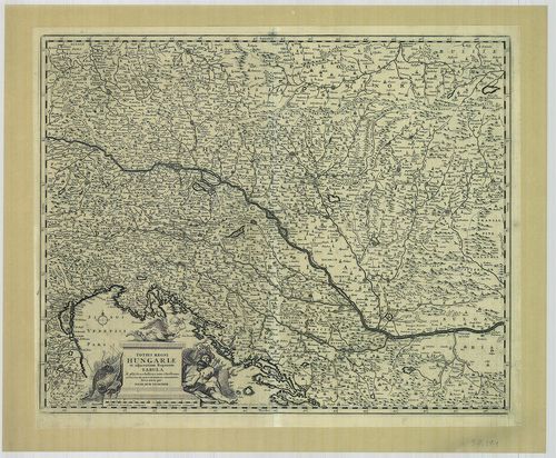
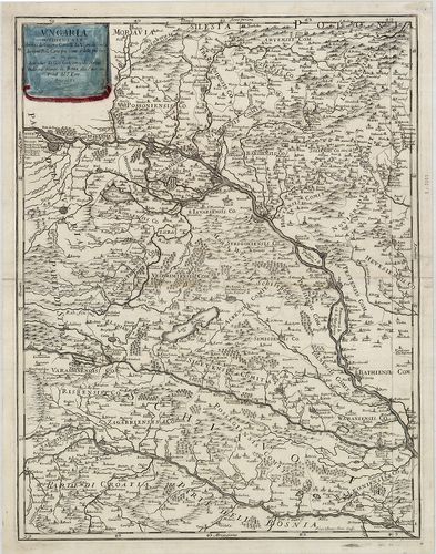
3875. Le Royaume de Hongrie Diuisé en Haute et Basse Hongrie auec ... [B IX a 490/1]
Institute and Museum of Military History •
B IX a
•
B IX Ausztria–Magyarország
•
B I–XV. Európa
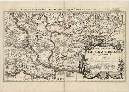
| Title | Le Royaume de Hongrie Diuisé en Haute et Basse Hongrie auec l’Esclavonie, Subdiuisees en leurs Comitez. Partie du Royaume de Hongrie, vers le Midy et l’Orient. |
| Main title | A Magyar Királyság D-i részének térképe 1688-ban, megyebeosztással és megnevezéssel. |
3876. Le Royaume de Hongrie divisé en Haute et Basse Hongrie, Tran... [B IX a 490/2]
Institute and Museum of Military History •
B IX a
•
B IX Ausztria–Magyarország
•
B I–XV. Európa
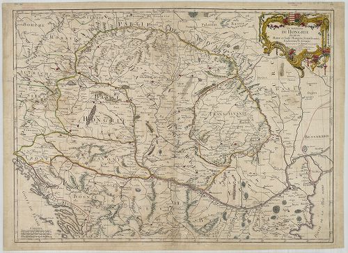
| Title | Le Royaume de Hongrie divisé en Haute et Basse Hongrie, Transilvanie, Esclavonie et Croatie. |
| Main title | A Magyar Királyság, Erdély és Horvát-Szlavónia térképe 1759-ben. |
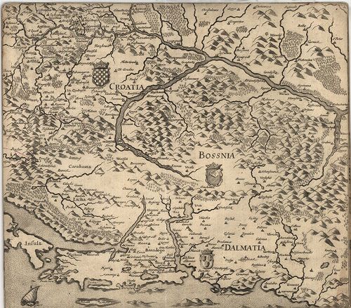
3877. Il Regno d’Ungaria, Transilvania, Schiavonia, Bosnia, Croati... [B IX a 490/3]
Institute and Museum of Military History •
B IX a
•
B IX Ausztria–Magyarország
•
B I–XV. Európa
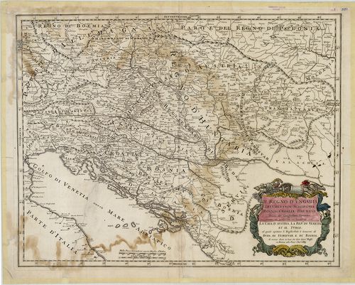
| Title | Il Regno d’Ungaria, Transilvania, Schiavonia, Bosnia, Croatia, Dalmatia… |
| Main title | A Magyar Királyság, Erdély, Szlavónia, Bosznia, Horvátország és Dalmácia térképe 1683-ban. |
3878. Ungaria Occidentale. [B IX a 490/4]
Institute and Museum of Military History •
B IX a
•
B IX Ausztria–Magyarország
•
B I–XV. Európa
| Title | Ungaria Occidentale. |
| Main title | Magyarország nyugati részének térképe 1683-ban. |
3879. Ungariae loca praecipua recens emendata atque edita… [B IX a 490/5]
Institute and Museum of Military History •
B IX a
•
B IX Ausztria–Magyarország
•
B I–XV. Európa
| Title | Ungariae loca praecipua recens emendata atque edita… |
| Main title | Magyarország térképe 1579-ben. |
3880. Landtafel des Ungerlands, Polands, Reussen, Littaw, Wallache... [B IX a 490/6]
Institute and Museum of Military History •
B IX a
•
B IX Ausztria–Magyarország
•
B I–XV. Európa
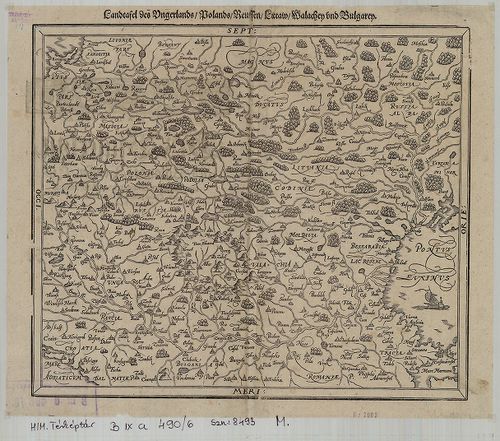
| Title | Landtafel des Ungerlands, Polands, Reussen, Littaw, Wallachey und Bulgarey. |
| Main title | Magyarország, Lengyelország, Oroszország, Litvánia, Havasalföld, Bulgária térképe a 16. században. |