4181. Magyarország közigazgatási térképe. 3 térkép. [B IX a 1007]
Institute and Museum of Military History •
B IX a
•
B IX Ausztria–Magyarország
•
B I–XV. Európa
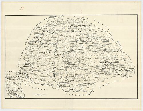
| Title | Magyarország közigazgatási térképe. 3 térkép. |
4182. Szatmár vármegye közigazgatási és földmívelési térképe. [B IX a 1008]
Institute and Museum of Military History •
B IX a
•
B IX Ausztria–Magyarország
•
B I–XV. Európa
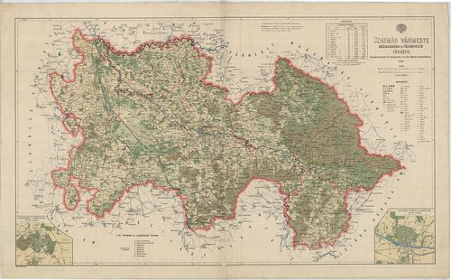
| Title | Szatmár vármegye közigazgatási és földmívelési térképe. |
| Main title | 2 mt. 1. Nagykároly (Carei) 2. Szatmár-Németi (Satu-Mare) és környéke. |
4183. Karte des Königreichs Ungarn des Wolfg. Lazius 1556. – Karte... [B IX a 1011]
Institute and Museum of Military History •
B IX a
•
B IX Ausztria–Magyarország
•
B I–XV. Európa
| Title | Karte des Königreichs Ungarn des Wolfg. Lazius 1556. – Karten der Österreichischen Lande und des Königreichs Ungarn. 1545–1563. |
| Main title | 1. Erzherzogtum Österreich 1545. (Osztrák főhercegség 1545-ben.) 2. Erzherzogtum Österreich 1563. (Osztrák főhercegség 1563-ban.) 3. Frankische Östmárk. (Frankföld K-i r.) 4. Nieder-Österreich (Alsó-Ausztria.) 5. Ober-Österreich. (Felső-Ausztria.) 6. Baiern. (Bajorország.) 7. Steiermark. (Stájerország.) 8. Krain. (Krajna.) 9. Kärnten. (Karintia.) 10. Tirol. 11. Schwaben. (Svábföld.) 12. Vorder-Österreich. (Ausztria Ny-i r.) 13. Görz und Istrien. (Gorizia és az Istriai félsziget.) 14., 15., 16., 17. Regni Hungariae Descriptio vera. (A Magyar Királyság térképe.) 18., 19. Latin nyelvű szöv. magy. 20. Kriegsschauplatz in Ungarn 1556. (Magyarország háborús térképe 1556-ban.) |
| Subject | Az Osztrák tartományok és Magyarország térképe. |
4184. Karte des Königreichs Ungarn 1556. „Regni Hungariae Descript... [B IX a 1011/1]
Institute and Museum of Military History •
B IX a
•
B IX Ausztria–Magyarország
•
B I–XV. Európa
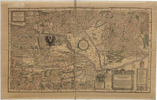
| Title | Karte des Königreichs Ungarn 1556. „Regni Hungariae Descriptio Vera" |
| Main title | A Magyar Királyság térképe 1556-ban. |
4185. Cartographia Hungarica. I. Magyarország térképei a XVI. és X... [B IX a 1012]
Institute and Museum of Military History •
B IX a
•
B IX Ausztria–Magyarország
•
B I–XV. Európa
| Title | Cartographia Hungarica. I. Magyarország térképei a XVI. és XVII. századból fakszimile kiadásban. |
4186. A Magyar Állam áttekintési földképe. [B IX a 1017]
Institute and Museum of Military History •
B IX a
•
B IX Ausztria–Magyarország
•
B I–XV. Európa
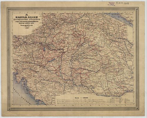
| Title | A Magyar Állam áttekintési földképe. |
4187. A Magyar Szent Korona Országai. [B IX a 1018]
Institute and Museum of Military History •
B IX a
•
B IX Ausztria–Magyarország
•
B I–XV. Európa
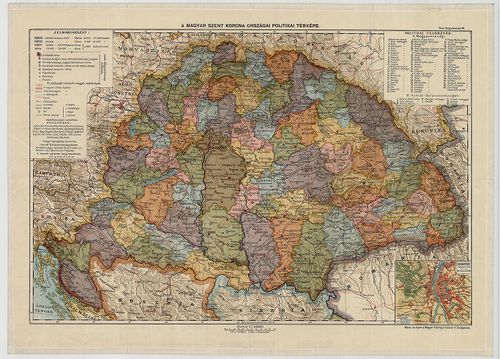
| Title | A Magyar Szent Korona Országai. |
| Main title | Mt. Budapest pályaudvarai. |
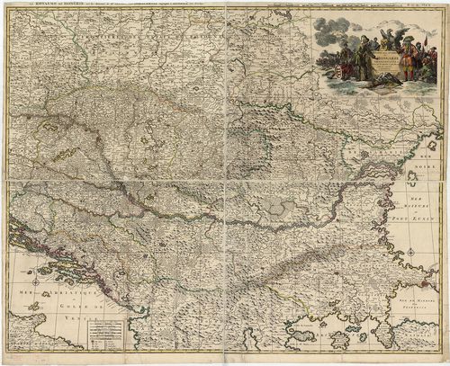
4188. Carte de la Hongrie et des Pays qui en dependoient autrefois... [B IX a 1021]
Institute and Museum of Military History •
B IX a
•
B IX Ausztria–Magyarország
•
B I–XV. Európa
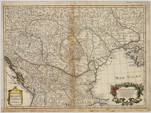
| Title | Carte de la Hongrie et des Pays qui en dependoient autrefois. |
| Main title | Magyarország és a társországok térképe. |
4189. Neue durch den lezten Krieg der drei Kaiserhőfe verbesserte ... [B IX a 1022]
Institute and Museum of Military History •
B IX a
•
B IX Ausztria–Magyarország
•
B I–XV. Európa
| Title | Neue durch den lezten Krieg der drei Kaiserhőfe verbesserte Geographische Karte samt den neuen bestimten Poststazionen… |
| Main title | A Duna menti országok térképe 1792-ben a postaállomások jelölésével. (Kremstől a Fekete-tengerig.) |
4190. Hungaria Generalis, divisa in proprie dictam Hungariam, Prin... [B IX a 1024]
Institute and Museum of Military History •
B IX a
•
B IX Ausztria–Magyarország
•
B I–XV. Európa
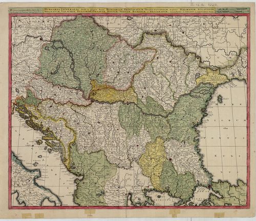
| Title | Hungaria Generalis, divisa in proprie dictam Hungariam, Principatum Transilvaniam, Regiones Dalmatiae, Sclavoniae, Moldaviae, Valachiae, Bulgariae, Croatiae, Bosniae, Serviae, Romaniae et Bessarábiae. |
| Main title | Magyarország és a Balkán-félsziget térképe a 18. század elején. |
4191. Regni Hungariae, Graeciae, et Moreae, ac Regionum quae ei qu... [B IX a 1025]
Institute and Museum of Military History •
B IX a
•
B IX Ausztria–Magyarország
•
B I–XV. Európa
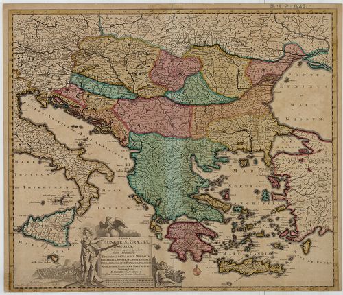
| Title | Regni Hungariae, Graeciae, et Moreae, ac Regionum quae ei quondam fuére Christiani, ut Transilvaniae, Valachiae, Moldaviae, Bessarabiae, Bosniae, Sclavoniae, Serviae, Bulgariae, Croatiae, Romaniae, Dalmatiae, Morlachiae, Ragusanae Republica… |
| Main title | A Magyar Királyság és a Balkán-félsziget térképe a 17. század végén, tartományi határszín. |
4192. Carte topographique d’allemagne Contenant une Partie du Roau... [B IX a 1026]
Institute and Museum of Military History •
B IX a
•
B IX Ausztria–Magyarország
•
B I–XV. Európa
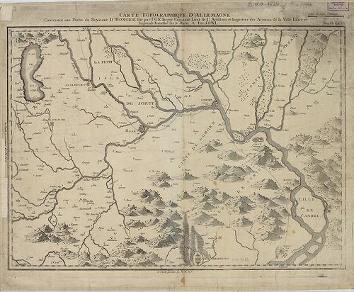
| Title | Carte topographique d’allemagne Contenant une Partie du Roaume D’Hongrie fait… |
| Main title | Magyarország: É-Dunántúl topográfiai térképe a 18. század végén. |
4193. Theatre de la Guerre en Hongrie, Transilvanie etc. [B IX a 1027]
Institute and Museum of Military History •
B IX a
•
B IX Ausztria–Magyarország
•
B I–XV. Európa
| Title | Theatre de la Guerre en Hongrie, Transilvanie etc. |
| Main title | Magyarország, Erdély térképe, tartományi határszín. |
4194. Nouvelle Carte di Theatre de la Guerre entre les Autrichiens... [B IX a 1029]
Institute and Museum of Military History •
B IX a
•
B IX Ausztria–Magyarország
•
B I–XV. Európa
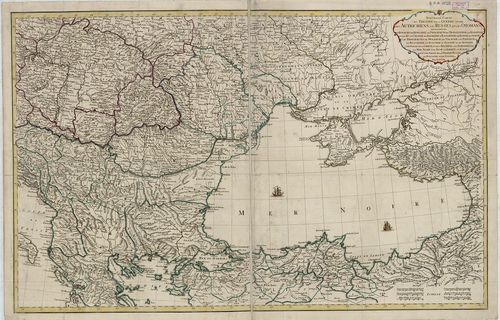
| Title | Nouvelle Carte di Theatre de la Guerre entre les Autrichiens, les Russes, et les Otomans… |
| Main title | Az Oszták, Orosz és a Török Birodalom országai (Magyarország-Fekete-tenger) a 18. század elején. |
4195. Charte von Ungarn, Siebenburgen, Slavonien, einem Theil von ... [B IX a 1030]
Institute and Museum of Military History •
B IX a
•
B IX Ausztria–Magyarország
•
B I–XV. Európa
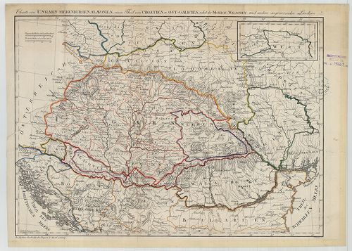
| Title | Charte von Ungarn, Siebenburgen, Slavonien, einem Theil von Croatien u. Ost-Galizien nebst der Moldau, Wallachey, und andern angrenzenden Ländern. |
| Main title | Magyarország, Erdély, Szlavónia-Horvátország, Kelet-Galícia, Moldva, Havasalföld térképe az 1770-es években. |
4196. Ungarn. In dieser Charten seyn zu seben die angränzende Länd... [B IX a 1031]
Institute and Museum of Military History •
B IX a
•
B IX Ausztria–Magyarország
•
B I–XV. Európa
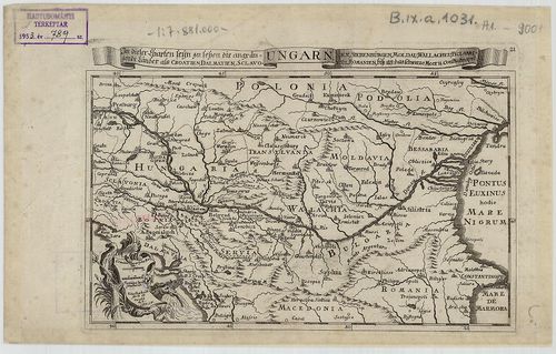
| Title | Ungarn. In dieser Charten seyn zu seben die angränzende Ländern als Croatien, Dalmatien, Sclavonien. Siebenbürgen, Moldau, Wallacheu Bulgarien, Romanien, bis an das schwarze Meer u. Constantinopel. |
| Main title | Magyarország, Erdély és a Balkán-félsziget államainak térképe a 18. század elején. |
4197. Das Reich der Ungern von 907. bis 1007. [B IX a 1032]
Institute and Museum of Military History •
B IX a
•
B IX Ausztria–Magyarország
•
B I–XV. Európa
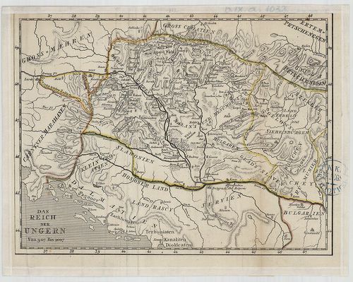
| Title | Das Reich der Ungern von 907. bis 1007. |
| Main title | Magyarország történelmi térképe a 10. század fordulóján. |
4198. Mappa Generalis Regni Hungariae partiumque adnexarum Croatia... [B IX a 1037]
Institute and Museum of Military History •
B IX a
•
B IX Ausztria–Magyarország
•
B I–XV. Európa
| Title | Mappa Generalis Regni Hungariae partiumque adnexarum Croatiae, Slavoniae, et Confiniorum Militarium Magni item Principatus Transylvaniae. |
| Main title | Magyarország, Horvát-Szlavónia és Erdély általános térképe 1806-ban. |
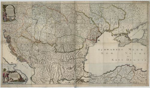
4199. Nova et accurata Tabula sedis belli in Regno Hungariae. Acce... [B IX a 1039]
Institute and Museum of Military History •
B IX a
•
B IX Ausztria–Magyarország
•
B I–XV. Európa
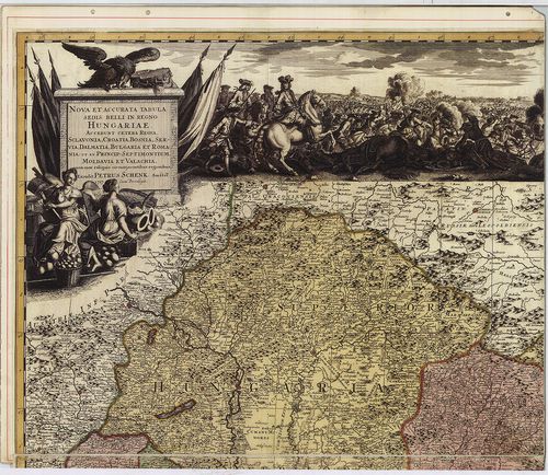
| Title | Nova et accurata Tabula sedis belli in Regno Hungariae. Accendunt cetera Regna Sclavonia, Croatia, Bosnia, Servia, Dalmatia, Bulgaria et Romania… |
| Main title | A Magyar Királyság , Horvát-Szlavónia, Bosznia, Szerbia, Dalmácia, Bulgária, Moldva, Erdély, Havasalföld térképe 1717-ben. |
4200. Magyarország, Horvát, Tót, Dalmát, Erdély országok, a’ tenge... [B IX a 1040]
Institute and Museum of Military History •
B IX a
•
B IX Ausztria–Magyarország
•
B I–XV. Európa
| Title | Magyarország, Horvát, Tót, Dalmát, Erdély országok, a’ tenger mellék, katonai Határőrvidék Földképe… – Karte des Königreiches Ungarn der Königreiche Croatien, Slavonien, Dalmatien, des Grossfürstenth. Siebenbürgen, des Küstenlandes und der Militair Grenze… |