4441. Sluin. [B IX a 1318]
Institute and Museum of Military History •
B IX a
•
B IX Ausztria–Magyarország
•
B I–XV. Európa
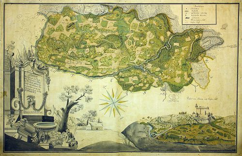
| Title | Sluin. |
| Main title | Sluin környékének térképe, jobb alsó sarokban a vár és a város látképével. |
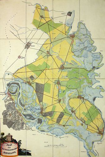
4442. Karte von dem Millitair District des Königreich Sclavonien u... [B IX a 1319]
Institute and Museum of Military History •
B IX a
•
B IX Ausztria–Magyarország
•
B I–XV. Európa
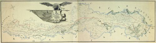
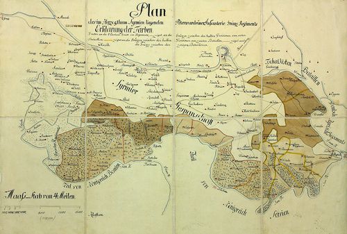
| Title | Karte von dem Millitair District des Königreich Sclavonien und Herzogthum Syrmien. |
| Main title | A Szlavón Határőrvidék és a Szerémség térképe. |
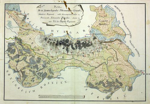
4443. Carte des Peterwardeiner Grenz Regiments und Tsaikisten Bat... [B IX a 1320]
Institute and Museum of Military History •
B IX a
•
B IX Ausztria–Magyarország
•
B I–XV. Európa
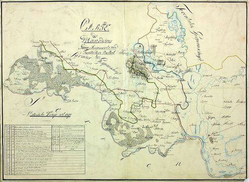
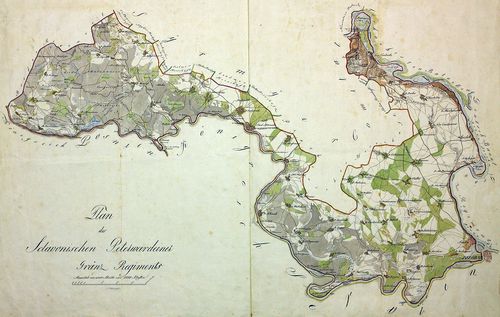
| Title | Carte des Peterwardeiner Grenz Regiments und Tsaikisten Battaillon. |
| Main title | A Péterváradi Határőrezred és a Csajkás ezred térképe. |
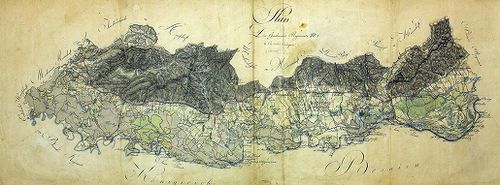
4444. Charte von der Lage des löbl. Broder Infanterie Grenz-Regime... [B IX a 1321]
Institute and Museum of Military History •
B IX a
•
B IX Ausztria–Magyarország
•
B I–XV. Európa
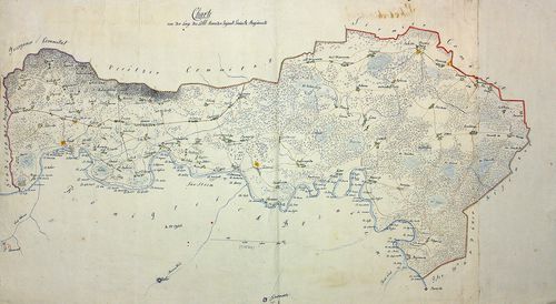
| Title | Charte von der Lage des löbl. Broder Infanterie Grenz-Regiments. |
| Main title | A Bródi határőr gyalogezred térképe. |
4445. Plan von der Laage des Kais. Königlichen Brooder Grenz Infan... [B IX a 1322]
Institute and Museum of Military History •
B IX a
•
B IX Ausztria–Magyarország
•
B I–XV. Európa
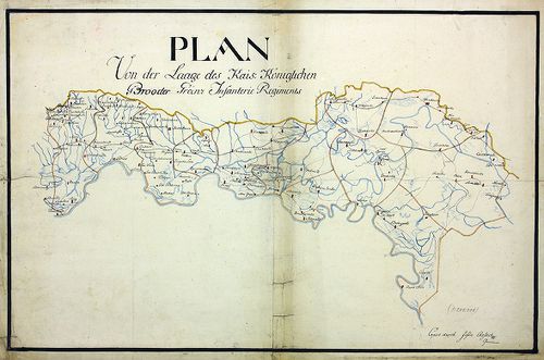
| Title | Plan von der Laage des Kais. Königlichen Brooder Grenz Infanterie Regiments. |
| Main title | A Bródi határőr gyalogezred térképe. |
4446. Mappa und Territorium des k. k. Broder Gräntz Regiments No. ... [B IX a 1323]
Institute and Museum of Military History •
B IX a
•
B IX Ausztria–Magyarország
•
B I–XV. Európa
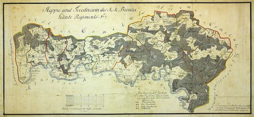
| Title | Mappa und Territorium des k. k. Broder Gräntz Regiments No. 7. |
| Main title | A Bródi 7. határőrezred térképe. |
4447. Charte des löb. Gradiscaner Regiments. [B IX a 1324]
Institute and Museum of Military History •
B IX a
•
B IX Ausztria–Magyarország
•
B I–XV. Európa
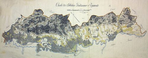
| Title | Charte des löb. Gradiscaner Regiments. |
| Main title | A Gradiscai ezred térképe. |
4448. Plan des Gradiscaner Regiments No. 8. [B IX a 1325]
Institute and Museum of Military History •
B IX a
•
B IX Ausztria–Magyarország
•
B I–XV. Európa
| Title | Plan des Gradiscaner Regiments No. 8. |
| Main title | A 8. Gradiscai ezred térképe. |
4449. Plan der Lage von K.K. Peterwardeiner Gränz Regiment. [B IX a 1326]
Institute and Museum of Military History •
B IX a
•
B IX Ausztria–Magyarország
•
B I–XV. Európa
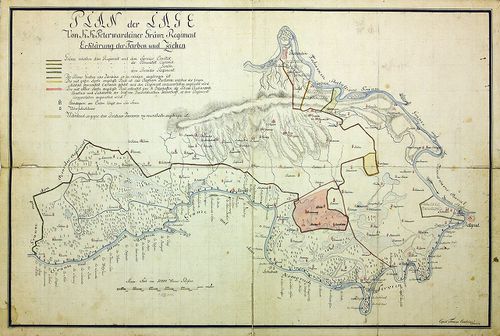
| Title | Plan der Lage von K.K. Peterwardeiner Gränz Regiment. |
| Main title | A Péterváradi határezred térképe. |
4450. Plan der in Syrmien liegenden Peterwardeiner Grenz-Infanteri... [B IX a 1327]
Institute and Museum of Military History •
B IX a
•
B IX Ausztria–Magyarország
•
B I–XV. Európa
| Title | Plan der in Syrmien liegenden Peterwardeiner Grenz-Infanterie Regiments. |
| Main title | A szerémségi Péterváradi határ-gyalogezred térképe. |
4451. Plan des in Syrmien liegenden Peterwardeiner Grenz-Infanteri... [B IX a 1328]
Institute and Museum of Military History •
B IX a
•
B IX Ausztria–Magyarország
•
B I–XV. Európa
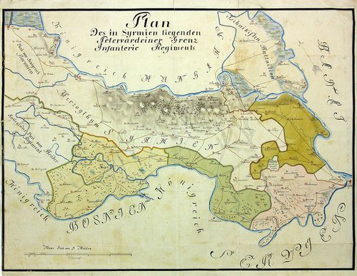
| Title | Plan des in Syrmien liegenden Peterwardeiner Grenz-Infanterie-Regiments. |
| Main title | A szerémségi Péterváradi határ-gyalogezred térképe. |
4452. Plan des in Herzogthum Syrmien liegenden Peterwardeiner -Inf... [B IX a 1329]
Institute and Museum of Military History •
B IX a
•
B IX Ausztria–Magyarország
•
B I–XV. Európa
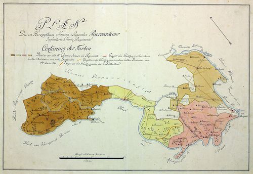
| Title | Plan des in Herzogthum Syrmien liegenden Peterwardeiner -Infanterie- Grenz -Regiments. |
| Main title | A szerémségi Péterváradi határ-gyalogezred térképe. |
4453. Plan des in Herzogthum Syrmien liegenden Peterwardeiner -Inf... [B IX a 1330]
Institute and Museum of Military History •
B IX a
•
B IX Ausztria–Magyarország
•
B I–XV. Európa
| Title | Plan des in Herzogthum Syrmien liegenden Peterwardeiner -Infanterie- Grenz -Regiments. |
| Main title | A szerémségi Péterváradi határ-gyalogezred térképe. |
4454. Plan des Slavonischen Peterwardeiner Gränz Regiments. [B IX a 1331]
Institute and Museum of Military History •
B IX a
•
B IX Ausztria–Magyarország
•
B I–XV. Európa
| Title | Plan des Slavonischen Peterwardeiner Gränz Regiments. |
| Main title | A szlavóniai Péterváradi határezred térképe. |
4455. Carte des Kais. König. Peterwardeiner Grenz-Regiments. [B IX a 1332]
Institute and Museum of Military History •
B IX a
•
B IX Ausztria–Magyarország
•
B I–XV. Európa
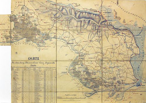
| Title | Carte des Kais. König. Peterwardeiner Grenz-Regiments. |
| Main title | A császári-királyi Péterváradi határezred térképe. |
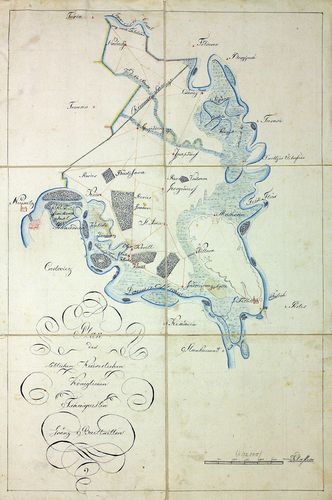
4456. Plan aller Gründe des k. k. Tschaikisten Bataillons-Cantons-... [B IX a 1333]
Institute and Museum of Military History •
B IX a
•
B IX Ausztria–Magyarország
•
B I–XV. Európa
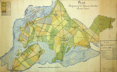
| Title | Plan aller Gründe des k. k. Tschaikisten Bataillons-Cantons-Bezirk. |
| Main title | A császári-királyi Csajkások térképe. |
4457. Plan des Tschaikisten Bataillons. [B IX a 1334]
Institute and Museum of Military History •
B IX a
•
B IX Ausztria–Magyarország
•
B I–XV. Európa
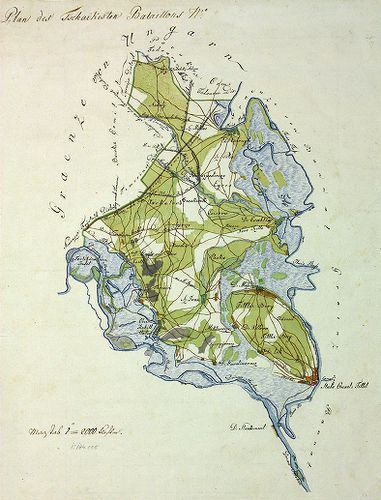
| Title | Plan des Tschaikisten Bataillons. |
| Main title | A Csajkás ezred térképe. |
4458. Plan des löblichen kaiserlichen königlichen Tschaikisten Gre... [B IX a 1335]
Institute and Museum of Military History •
B IX a
•
B IX Ausztria–Magyarország
•
B I–XV. Európa
| Title | Plan des löblichen kaiserlichen königlichen Tschaikisten Grenz-Bataillons. |
| Main title | A Csajkás határezred térképe. |
4459. Plan des k. k. Czaikisten Grenz-Bataillons. [B IX a 1336]
Institute and Museum of Military History •
B IX a
•
B IX Ausztria–Magyarország
•
B I–XV. Európa
| Title | Plan des k. k. Czaikisten Grenz-Bataillons. |
| Main title | A Csajkás határezred térképe. |
4460. Plan vom Syrmier Comitat. [B IX a 1337]
Institute and Museum of Military History •
B IX a
•
B IX Ausztria–Magyarország
•
B I–XV. Európa
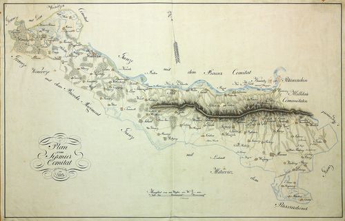
| Title | Plan vom Syrmier Comitat. |
| Main title | A Szerémség térképe. |