2601. Nordrhein-Westfalen. [B IV c 429]
Institute and Museum of Military History •
B IV c
•
B IV Német birodalom
•
B I–XV. Európa
| Title | Nordrhein-Westfalen. |
2602. Elsass Lothringen. [B IV c 430]
Institute and Museum of Military History •
B IV c
•
B IV Német birodalom
•
B I–XV. Európa
| Title | Elsass Lothringen. |
| Main title | Elzász-Lotaringia autótérképe (Németország). |
2603. Autokarte Südwestdeutschland [B IV c 431]
Institute and Museum of Military History •
B IV c
•
B IV Német birodalom
•
B I–XV. Európa
| Title | Autokarte Südwestdeutschland |
2604. Wanderkarte Saabach - Hinterglemm [B IV c 432]
Institute and Museum of Military History •
B IV c
•
B IV Német birodalom
•
B I–XV. Európa
| Title | Wanderkarte Saabach - Hinterglemm |
2605. Brandenburg Havel. [B IV c 433]
Institute and Museum of Military History •
B IV c
•
B IV Német birodalom
•
B I–XV. Európa
| Title | Brandenburg Havel. |
2606. Ostseeküste. [B IV c 434]
Institute and Museum of Military History •
B IV c
•
B IV Német birodalom
•
B I–XV. Európa
| Title | Ostseeküste. |
2607. Neuss mit Mönchengladbach. [B IV c 435]
Institute and Museum of Military History •
B IV c
•
B IV Német birodalom
•
B I–XV. Európa
| Title | Neuss mit Mönchengladbach. |
2608. Bersenbrücker Land. [B IV c 436]
Institute and Museum of Military History •
B IV c
•
B IV Német birodalom
•
B I–XV. Európa
| Title | Bersenbrücker Land. |
2609. Unteres Altmühltal - Regensburg. [B IV c 437]
Institute and Museum of Military History •
B IV c
•
B IV Német birodalom
•
B I–XV. Európa
| Title | Unteres Altmühltal - Regensburg. |
2610. Umgebung von Berlin. [B IV c 438]
Institute and Museum of Military History •
B IV c
•
B IV Német birodalom
•
B I–XV. Európa
| Title | Umgebung von Berlin. |
2611. Autokarte. [B IV c 439]
Institute and Museum of Military History •
B IV c
•
B IV Német birodalom
•
B I–XV. Európa
| Title | Autokarte. |
2612. Olex Autokarte Süddeutschland. [B IV c 440]
Institute and Museum of Military History •
B IV c
•
B IV Német birodalom
•
B I–XV. Európa
| Title | Olex Autokarte Süddeutschland. |
2613. Bundesrepublik Deutschland, Deutche Demokratische Republik. [B IV c 441]
Institute and Museum of Military History •
B IV c
•
B IV Német birodalom
•
B I–XV. Európa
| Title | Bundesrepublik Deutschland, Deutche Demokratische Republik. |
2614. Bundesrepublik Deutschland, Deutche Demokratische Republik. [B IV c 442]
Institute and Museum of Military History •
B IV c
•
B IV Német birodalom
•
B I–XV. Európa
| Title | Bundesrepublik Deutschland, Deutche Demokratische Republik. |
2615. Campingkarte der DDR. [B IV c 443]
Institute and Museum of Military History •
B IV c
•
B IV Német birodalom
•
B I–XV. Európa
| Title | Campingkarte der DDR. |
2616. Berchtesgaden. [B IV c 445]
Institute and Museum of Military History •
B IV c
•
B IV Német birodalom
•
B I–XV. Európa
| Title | Berchtesgaden. |
2617. Karte der Verkehrswege 1200 Meilen um Berlin für Rad- und Au... [B IV c 446]
Institute and Museum of Military History •
B IV c
•
B IV Német birodalom
•
B I–XV. Európa
| Title | Karte der Verkehrswege 1200 Meilen um Berlin für Rad- und Auto-Fahrer. |
2618. Gallia Benedictina seu Abbatiae et Prioratus tam Monachorum ... [B V a 2]
Institute and Museum of Military History •
B V a
•
B V Franciaország
•
B I–XV. Európa
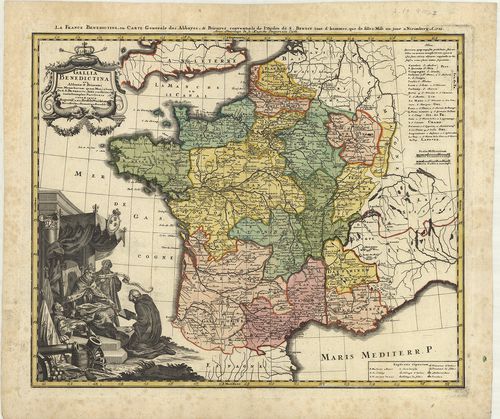
| Title | Gallia Benedictina seu Abbatiae et Prioratus tam Monachorum quam Monialium Ord. S. Benedicti ibide existetes iuxta Exemplar Parisiense. |
| Main title | Franciaország Szt. Benedek-rend apátságainak térképe 1738-ban. |
2619. Gallia. [B V a 3]
Institute and Museum of Military History •
B V a
•
B V Franciaország
•
B I–XV. Európa
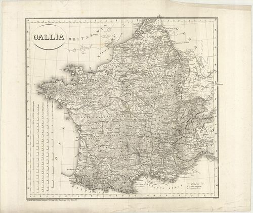
| Title | Gallia. |
| Main title | Franciaország térképe 1820-ban. |
2620. Gallia Augustiniana in suas Provinzias divisa… [B V a 4]
Institute and Museum of Military History •
B V a
•
B V Franciaország
•
B I–XV. Európa

| Title | Gallia Augustiniana in suas Provinzias divisa… |
| Main title | Franciaország Ágostonrendi szerzetesi rendtartományai a 18. században. |