2901. France, Carte routiére et touristique. [B V c 181]
Institute and Museum of Military History •
B V c
•
B V Franciaország
•
B I–XV. Európa
| Title | France, Carte routiére et touristique. |
2902. France routiére départementale. [B V c 182]
Institute and Museum of Military History •
B V c
•
B V Franciaország
•
B I–XV. Európa
| Title | France routiére départementale. |
| Main title | 2 mt.: Relief de la France. Sorties de Paris. (Franviaország domborzata. Párizs környéke. |
2903. Provence. [B V c 183]
Institute and Museum of Military History •
B V c
•
B V Franciaország
•
B I–XV. Európa
| Title | Provence. |
| Main title | Franciaország áttek. térképe. |
2904. Corse-du Sud, Haute Corse. [B V c 184]
Institute and Museum of Military History •
B V c
•
B V Franciaország
•
B I–XV. Európa
| Title | Corse-du Sud, Haute Corse. |
2905. France. [B V c 185]
Institute and Museum of Military History •
B V c
•
B V Franciaország
•
B I–XV. Európa
| Title | France. |
| Main title | Franciaország autótérképe |
2906. France Direct route map. [B V c 186]
Institute and Museum of Military History •
B V c
•
B V Franciaország
•
B I–XV. Európa
| Title | France Direct route map. |
2907. Carte Nautique & touristique de la vallée de l´Ardéche [B V c 187]
Institute and Museum of Military History •
B V c
•
B V Franciaország
•
B I–XV. Európa
| Title | Carte Nautique & touristique de la vallée de l´Ardéche |
2908. Territorial Eintheilungs u. Dislokations Karte. (+1 mellékté... [B V c 188]
Institute and Museum of Military History •
B V c
•
B V Franciaország
•
B I–XV. Európa
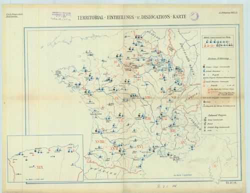
| Title | Territorial Eintheilungs u. Dislokations Karte. (+1 melléktérkép Algéria). |
| Main title | A francia hadsereg diszlokációs térképe. |
2909. Facies orbis septentrionalis ad mentem Ptolemaei. A. H. XXXI... [B VI a 2]
Institute and Museum of Military History •
B VI a
•
B VI Anglia, Skócia és Írország
•
B I–XV. Európa
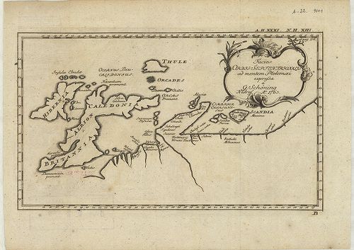
| Title | Facies orbis septentrionalis ad mentem Ptolemaei. A. H. XXXI. N. H. XIII. |
| Main title | Az északi földrész térképe: Nagybritannia és Írország Ptolemaiosz elképzelése szerint. |
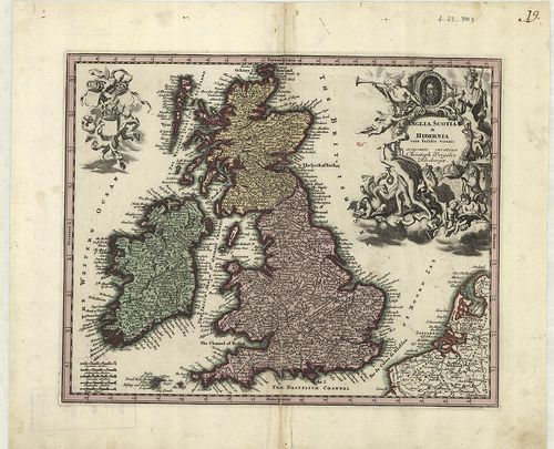
2910. Tabula novissima accuratissima Regnorum Angliae, Scoatiae, H... [B VI a 7]
Institute and Museum of Military History •
B VI a
•
B VI Anglia, Skócia és Írország
•
B I–XV. Európa
| Title | Tabula novissima accuratissima Regnorum Angliae, Scoatiae, Hibérniae. |
| Main title | Anglia, Skócia és Írország általános térképe a 18. században. |
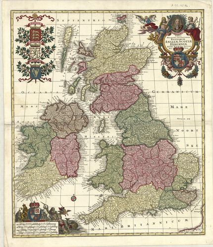
2911. Anglia, Scotia et Hibernia cum Insulis vicinis. [B VI a 8]
Institute and Museum of Military History •
B VI a
•
B VI Anglia, Skócia és Írország
•
B I–XV. Európa
| Title | Anglia, Scotia et Hibernia cum Insulis vicinis. |
| Main title | Anglia, Skócia és Írország általános térképe a 18. században. |
2912. Charte der vereinigten Königeriche Grossbritannien und Irlan... [B VI a 9]
Institute and Museum of Military History •
B VI a
•
B VI Anglia, Skócia és Írország
•
B I–XV. Európa
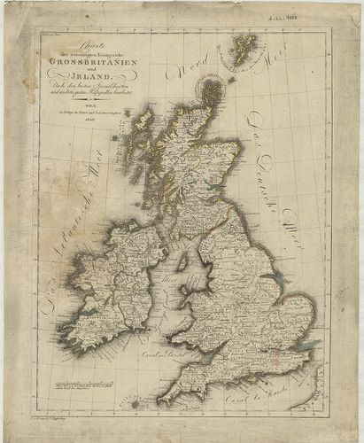
| Title | Charte der vereinigten Königeriche Grossbritannien und Irland. |
| Main title | Nagybritannia és Írország általános térképe 1806-ban. |
2913. Die Britischen Inseln und das umliegende Meer. [B VI a 10]
Institute and Museum of Military History •
B VI a
•
B VI Anglia, Skócia és Írország
•
B I–XV. Európa
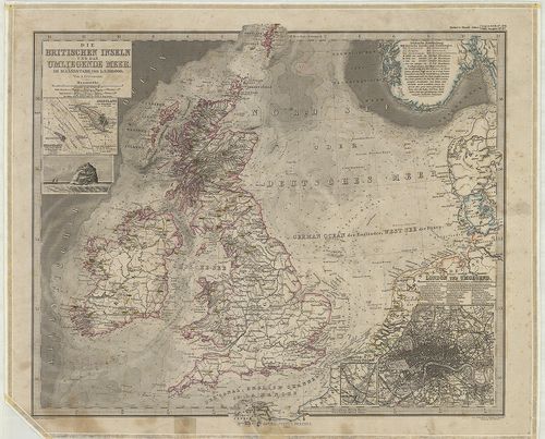
| Title | Die Britischen Inseln und das umliegende Meer. |
| Main title | 3 mt.: 1. Helgoland. |
| Subject | 2. Helgoland und die Düne. |
2914. Schlag nach über England. [B VI a 11]
Institute and Museum of Military History •
B VI a
•
B VI Anglia, Skócia és Írország
•
B I–XV. Európa
| Title | Schlag nach über England. |
| Main title | 2 térk.: 1. Grossbritannien und Irland. |
| Subject | (Nagybritannia és Írország.) 2. Politische Karte der Erde. (A világ politikai térképe.) |
2915. A General Map of Great Britain and Ireland… – Regnorum Magna... [B VI a 12]
Institute and Museum of Military History •
B VI a
•
B VI Anglia, Skócia és Írország
•
B I–XV. Európa
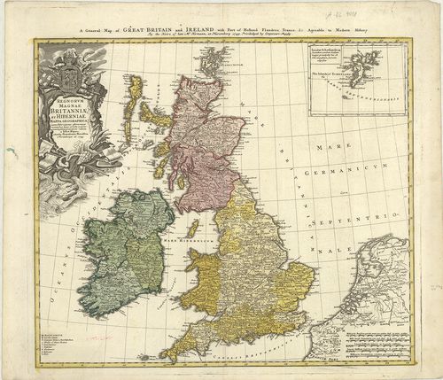
| Title | A General Map of Great Britain and Ireland… – Regnorum Magnae Britanniae et Hiberniae… |
| Main title | Mt.: Insulae Schetlandicae. (Shetland-szk.) |
| Subject | Nagy-Britannia és Írország általános térképe 1749-ben. |
2916. British Atlas, Comprising separate maps of every County in E... [B VI a 13/1]
Institute and Museum of Military History •
B VI a
•
B VI Anglia, Skócia és Írország
•
B I–XV. Európa
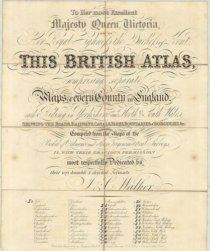
| Title | British Atlas, Comprising separate maps of every County in England… |
| Main title | 1. Northamptonshire. 2. Northumberland. 3. Nottinghamshire. 4. Oxfordshire. 5. Rutlandshire. 6. Shorpshire. 7. Somersetshire. 8. Staffordshire. 9. Suffolk. 10. Surrey. 11. Sussex. 12. Warwickshire. 13. Wiltshire. 14. Yorkshire, West Riding. 15. Yorkshire, North Riding. 16. Wales, North West. 17. Wales, North-East. 18. Wales, South-West. 19. Wales, South-East.Anglia grófságainak általános térképe 1837-ben. |
2917. Cary’s Traveller’s companion or, a Delineation of the Turnpi... [B VI a 13/2]
Institute and Museum of Military History •
B VI a
•
B VI Anglia, Skócia és Írország
•
B I–XV. Európa
| Title | Cary’s Traveller’s companion or, a Delineation of the Turnpike Roads of England and Wales … |
2918. Index shewing the progress of the ordnance survey of the Sou... [B VI a 14]
Institute and Museum of Military History •
B VI a
•
B VI Anglia, Skócia és Írország
•
B I–XV. Európa
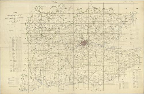
| Title | Index shewing the progress of the ordnance survey of the South Eastern Counties of England. |
| Main title | Anglia DK-i grófságainak katonai térképe. |
2919. Anglia Skotzia és Irlandia földképe. [B VI a 15]
Institute and Museum of Military History •
B VI a
•
B VI Anglia, Skócia és Írország
•
B I–XV. Európa
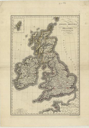
| Title | Anglia Skotzia és Irlandia földképe. |
| Main title | Anglia, Skócia és Írország térképe 1840 körül. |
2920. Karte von Grossbritannien und Ireland. X. [B VI a 16]
Institute and Museum of Military History •
B VI a
•
B VI Anglia, Skócia és Írország
•
B I–XV. Európa
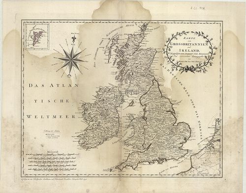
| Title | Karte von Grossbritannien und Ireland. X. |
| Main title | Nagy-Britannia és Írország általános térképe 1795-ben. |