6181. Theatre de la Guerre dans le Bannat de Temesvár. [B IX c 677]
Institute and Museum of Military History •
B IX c
•
B IX Ausztria–Magyarország
•
B I–XV. Európa
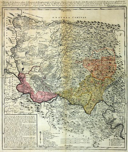
| Title | Theatre de la Guerre dans le Bannat de Temesvár. |
| Main title | A Temesi-Bánság hadszíntere 1738-ban. |
6182. Dislocations Carte von Ungarn de Anno 1781. [B IX c 685]
Institute and Museum of Military History •
B IX c
•
B IX Ausztria–Magyarország
•
B I–XV. Európa
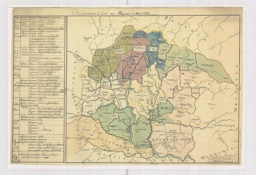
| Title | Dislocations Carte von Ungarn de Anno 1781. |
| Main title | Magyarország diszlokációs térképe 1781-ben. |
6183. Strassen-Karte des Königreiches Ungarn. [B IX c 690]
Institute and Museum of Military History •
B IX c
•
B IX Ausztria–Magyarország
•
B I–XV. Európa
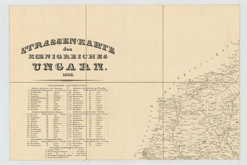
| Title | Strassen-Karte des Königreiches Ungarn. |
| Main title | Magyarország úttérképe 1832-ben. |
6184. [Magyarország.] Magyar-Ország és a hozzá kapcsolt Részek Had... [B IX c 691]
Institute and Museum of Military History •
B IX c
•
B IX Ausztria–Magyarország
•
B I–XV. Európa
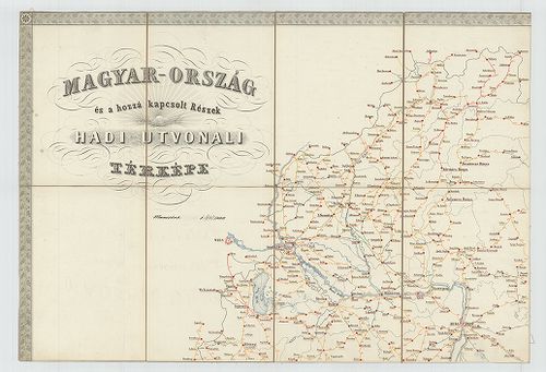
| Title | [Magyarország.] Magyar-Ország és a hozzá kapcsolt Részek Hadi-Útvonali térképe. |
6185. Marschrouten-Karte des Königreiches Ungarn nach den neuesten... [B IX c 696]
Institute and Museum of Military History •
B IX c
•
B IX Ausztria–Magyarország
•
B I–XV. Európa
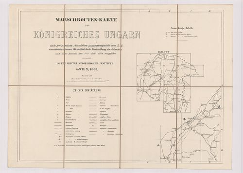
| Title | Marschrouten-Karte des Königreiches Ungarn nach den neuesten Materialien zusammengestellt… vom 1-ten Juli. 1868. |
| Main title | Magyarország menettérképe 1868-ban. |
6186. Marschrouten-Karte des Königreichs Ungarn nach den neuesten ... [B IX c 697]
Institute and Museum of Military History •
B IX c
•
B IX Ausztria–Magyarország
•
B I–XV. Európa
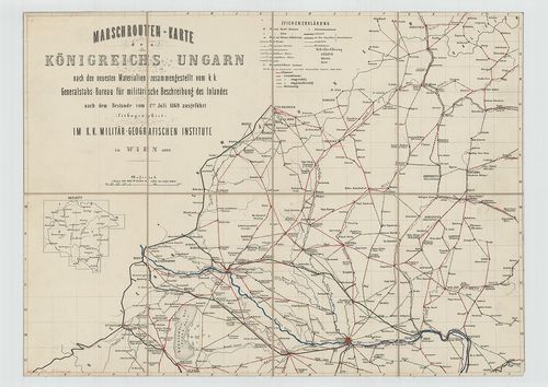
| Title | Marschrouten-Karte des Königreichs Ungarn nach den neuesten Materialien zusammengestellt… vom 1-ten Juli 1869. |
| Main title | Magyarország menettérképe 1869-ben. Az úttávolságok bejelölve. |
6187. [Magyarország.] A Magyar Korona államterületének honvédségi ... [B IX c 698]
Institute and Museum of Military History •
B IX c
•
B IX Ausztria–Magyarország
•
B I–XV. Európa
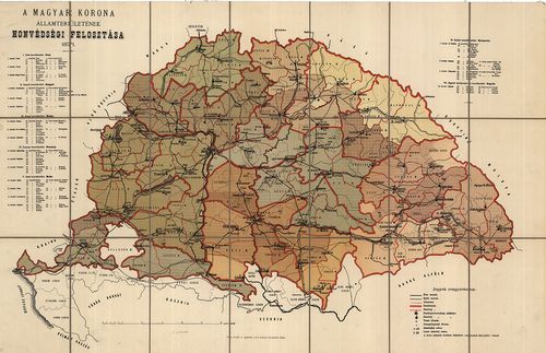
| Title | [Magyarország.] A Magyar Korona államterületének honvédségi felosztása. |
6188. [Magyarország.] A Magyar Korona Államterületének közigazgatá... [B IX c 698/1]
Institute and Museum of Military History •
B IX c
•
B IX Ausztria–Magyarország
•
B I–XV. Európa
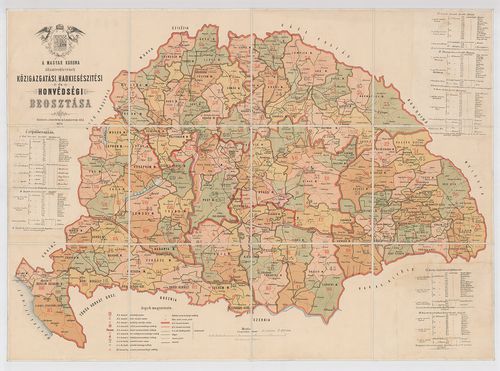
| Title | [Magyarország.] A Magyar Korona Államterületének közigazgatási Hadkiegészítési és Honvédségi beosztása. |
6189. [Magyarország.] A Magyar Korona Országainak Hadkiegészítési ... [B IX c 699]
Institute and Museum of Military History •
B IX c
•
B IX Ausztria–Magyarország
•
B I–XV. Európa
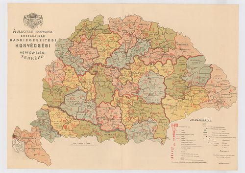
| Title | [Magyarország.] A Magyar Korona Országainak Hadkiegészítési és Honvédségi térképe. |
6190. Marsch und Reise Karte des Oesterreichishcen Kaiserstaates. [B IX c 700]
Institute and Museum of Military History •
B IX c
•
B IX Ausztria–Magyarország
•
B I–XV. Európa
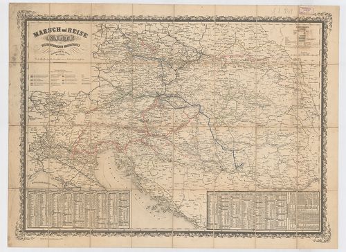
| Title | Marsch und Reise Karte des Oesterreichishcen Kaiserstaates. |
| Main title | Az Osztrák Császárság közlekedési térképe. |
6191. Episcopalis Dioecesis Jaurinensis In una Generali, et Sex Sp... [B IX c 704/2]
Institute and Museum of Military History •
B IX c
•
B IX Ausztria–Magyarország
•
B I–XV. Európa
| Title | Episcopalis Dioecesis Jaurinensis In una Generali, et Sex Specialibus Tabulis cum Repertorio exhibita. |
6192. Magyarország Egyházi közigazgatási térképe. [B IX c 704/3]
Institute and Museum of Military History •
B IX c
•
B IX Ausztria–Magyarország
•
B I–XV. Európa
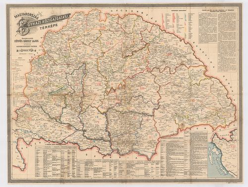
| Title | Magyarország Egyházi közigazgatási térképe. |
6193. Az Erdélyi ev.[angélikus] ref.[ormátus] egyházkerület térkép... [B IX c 704/4]
Institute and Museum of Military History •
B IX c
•
B IX Ausztria–Magyarország
•
B I–XV. Európa
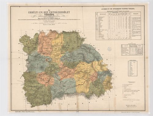
| Title | Az Erdélyi ev.[angélikus] ref.[ormátus] egyházkerület térképe. |
| Main title | Az „Erdélyi prot[estáns] Közlöny” 1877-i évi folyamának mell. |
6194. Magyarország Erdélyi részének turista térképe. [B IX c 704/5]
Institute and Museum of Military History •
B IX c
•
B IX Ausztria–Magyarország
•
B I–XV. Európa
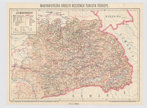
| Title | Magyarország Erdélyi részének turista térképe. |
| Main title | Homolka-féle „Magyarország Térképe” részlete. |
6195. Mappa Archi Dioecesis Strigoniensis, in Vicariatus. [B IX c 705]
Institute and Museum of Military History •
B IX c
•
B IX Ausztria–Magyarország
•
B I–XV. Európa
| Title | Mappa Archi Dioecesis Strigoniensis, in Vicariatus. |
| Main title | Mt. Az Esztergomi püspöki palota látképe. |
| Subject | Az Esztergomi egyházkerület térképe 1822-ben. |
6196. Mappa Geographica Almae Dioecesis Weszprimiensis per Inclyto... [B IX c 706/1]
Institute and Museum of Military History •
B IX c
•
B IX Ausztria–Magyarország
•
B I–XV. Európa
| Title | Mappa Geographica Almae Dioecesis Weszprimiensis per Inclytos Comitatus Weszprim, Simigh, et Zala… |
| Main title | A Veszprémi egyházmegye térképe 1841-ben. (Veszprém, Somogy-, Zala v. m. területe.) |
6197. [Ethnographische Karte der Comitat Marmaros.] [B IX c 709]
Institute and Museum of Military History •
B IX c
•
B IX Ausztria–Magyarország
•
B I–XV. Európa
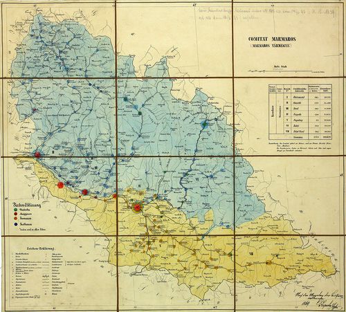
| Title | [Ethnographische Karte der Comitat Marmaros.] |
| Main title | Máramaros megye néprajzi térképe. |
6198. [Magyarország.] A magyar sz.[ent] korona országainak ethnogr... [B IX c 710]
Institute and Museum of Military History •
B IX c
•
B IX Ausztria–Magyarország
•
B I–XV. Európa

| Title | [Magyarország.] A magyar sz.[ent] korona országainak ethnographiai térképe az 1880-ik évi népszámlálás adatai alapján. |
6199. Magyarország néprajzi térképe. Az 1900. évi népszámlálás sze... [B IX c 710/1]
Institute and Museum of Military History •
B IX c
•
B IX Ausztria–Magyarország
•
B I–XV. Európa
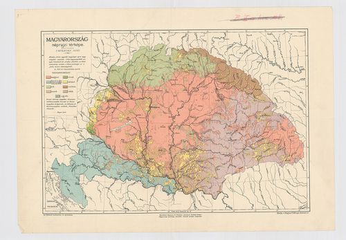
| Title | Magyarország néprajzi térképe. Az 1900. évi népszámlálás szerint. |
6200. Slovakien, Galizien, Bukowina, Siebenbürgen. [B IX c 710/2]
Institute and Museum of Military History •
B IX c
•
B IX Ausztria–Magyarország
•
B I–XV. Európa
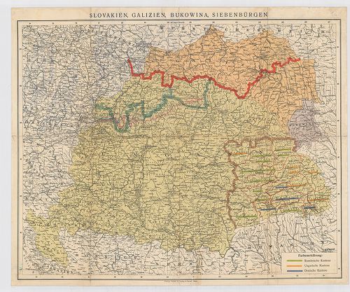
| Title | Slovakien, Galizien, Bukowina, Siebenbürgen. |
| Main title | Magyarország, Szlovákia, Galícia, Bukovina, Erdély néprajzi térképe 1920 körül, nemzetiségi többség alapján osztályozva. |