7201. Strassenzustand in Polen. 1939. [B XI c 153]
Institute and Museum of Military History •
B XI c
•
B XI Oroszország
•
B I–XV. Európa
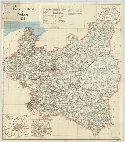
| Title | Strassenzustand in Polen. 1939. |
| Main title | 2 mt.: 1. Warschau und Umgebung. (Varsó és környéke.) 2. Industriegebiet. (Iparvidék.)Lengyelország úttérképe 1939-ben. |
7202. Republique Polonaise. – Republic of Poland. [B XI c 154]
Institute and Museum of Military History •
B XI c
•
B XI Oroszország
•
B I–XV. Európa
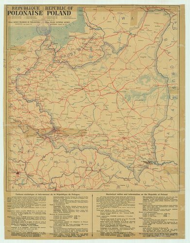
| Title | Republique Polonaise. – Republic of Poland. |
| Main title | A Lengyel Köztársaság közlekedési térképe 1930 körül. |
7203. Der Kriegsschauplatz in Polen. Flemmings Kriegskarte. Nr. 15... [B XI c 155]
Institute and Museum of Military History •
B XI c
•
B XI Oroszország
•
B I–XV. Európa
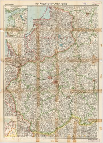
| Title | Der Kriegsschauplatz in Polen. Flemmings Kriegskarte. Nr. 15. |
| Main title | 3 mt.: 1. Die Russischen Ostseeprovinzen. (Az orosz Keleti-tenger tartományai.) 2. Nördlichster Teil der Provinz Ostpreussen. (Kreis Memel im Anschluss an die Hauptkarte.) Kelet-Poroszország északi tartománya (Memel kerület) csatlakozva a főtérképhez. 3. Früheres preuss und österreich, Gebiet in Polen. (Korábbi porosz és osztrák területek Lengyelországban.) hátl.: Umgebung der Festungen Warschau und Nowo-Georgiewsk. (Varsó és Nowo-Georgiewsk környéke a rövidítésekkel.)A lengyelországi hadszíntér az erődítések rajzával. |
7204. Tatry i Pieniny mapa turystyczna. [B XI c 156]
Institute and Museum of Military History •
B XI c
•
B XI Oroszország
•
B I–XV. Európa
| Title | Tatry i Pieniny mapa turystyczna. |
| Main title | Mt.: Zakopane |
7205. Beskid Sadecki. Mapa turystyczna. [B XI c 157]
Institute and Museum of Military History •
B XI c
•
B XI Oroszország
•
B I–XV. Európa
| Title | Beskid Sadecki. Mapa turystyczna. |
7206. Csernomorszkoe poberezse Kavkaza. Turisztszkaja szhema. [B XI c 158]
Institute and Museum of Military History •
B XI c
•
B XI Oroszország
•
B I–XV. Európa
| Title | Csernomorszkoe poberezse Kavkaza. Turisztszkaja szhema. |
7207. Centralnüj Kavkaz (Prielbrusze) Turisztszkaja szhema. [B XI c 159]
Institute and Museum of Military History •
B XI c
•
B XI Oroszország
•
B I–XV. Európa
| Title | Centralnüj Kavkaz (Prielbrusze) Turisztszkaja szhema. |
7208. Teberda–Dombaj. Turisztszkaja szhema. [B XI c 160]
Institute and Museum of Military History •
B XI c
•
B XI Oroszország
•
B I–XV. Európa
| Title | Teberda–Dombaj. Turisztszkaja szhema. |
| Main title | 1 kép: Panorama csaszti glavnogo Kavkazszkogo hrebta. (Rajon Teberda-Dombaj) (A Kaukázus madártávlatos képe.) |
| Subject | A Kaukázus, Teberda és Dombaj vidékének turistatérképe. |
7209. At the Map of the USSR. [B XI c 162]
Institute and Museum of Military History •
B XI c
•
B XI Oroszország
•
B I–XV. Európa
| Title | At the Map of the USSR. |
7210. Krim. Turisztszkaja szhema. [B XI c 163]
Institute and Museum of Military History •
B XI c
•
B XI Oroszország
•
B I–XV. Európa
| Title | Krim. Turisztszkaja szhema. |
7211. Krim. Turisztszkaja karta-szhema. [B XI c 163/1]
Institute and Museum of Military History •
B XI c
•
B XI Oroszország
•
B I–XV. Európa
| Title | Krim. Turisztszkaja karta-szhema. |
7212. Valdajszkaja vozvüsennoszt. Turisztszkaja szhema. [B XI c 164]
Institute and Museum of Military History •
B XI c
•
B XI Oroszország
•
B I–XV. Európa
| Title | Valdajszkaja vozvüsennoszt. Turisztszkaja szhema. |
7213. Architekturnüe pamjatniki Moszkovszkoj oblaszti. [B XI c 165]
Institute and Museum of Military History •
B XI c
•
B XI Oroszország
•
B I–XV. Európa
| Title | Architekturnüe pamjatniki Moszkovszkoj oblaszti. |
7214. Les nivellements de precision dans la Russie d’Europe et d’A... [B XI c 166]
Institute and Museum of Military History •
B XI c
•
B XI Oroszország
•
B I–XV. Európa
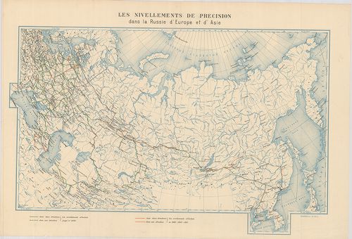
| Title | Les nivellements de precision dans la Russie d’Europe et d’Asie. |
| Main title | Az Európai és Ázsiai Oroszország pontos felmérés szerint. |
7215. Triangulation en Russie d’Europe. [B XI c 167]
Institute and Museum of Military History •
B XI c
•
B XI Oroszország
•
B I–XV. Európa
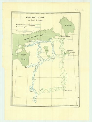
| Title | Triangulation en Russie d’Europe. |
| Main title | Északnyugat-Oroszország háromszögelési pontjai 1890 körül. |
7216. Triangulation le long de la Riviére Irtych. (Siberie Occiden... [B XI c 168]
Institute and Museum of Military History •
B XI c
•
B XI Oroszország
•
B I–XV. Európa
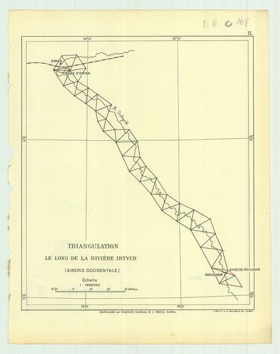
| Title | Triangulation le long de la Riviére Irtych. (Siberie Occidentale.) II. |
| Main title | Háromszögelési pontok az Irtis folyó mentén 1890 körül (Nyugat-Szibéria.) |
7217. Triangulation de la contrée Transbaicalienne. III. [B XI c 169]
Institute and Museum of Military History •
B XI c
•
B XI Oroszország
•
B I–XV. Európa
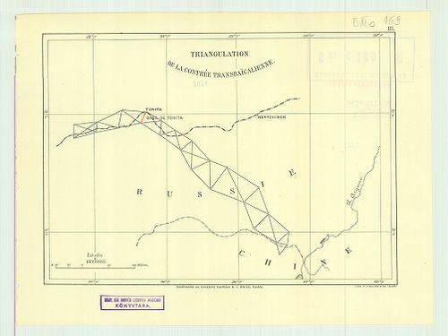
| Title | Triangulation de la contrée Transbaicalienne. III. |
| Main title | A Bajkálon túli terület háromszögelési pontjai 1890 körül. |
7218. Triangulation pour relier le réseau Russe de Turkestan avec ... [B XI c 170]
Institute and Museum of Military History •
B XI c
•
B XI Oroszország
•
B I–XV. Európa

| Title | Triangulation pour relier le réseau Russe de Turkestan avec le réseau des Indes. IV. |
| Main title | Oroszország és Turkesztán háromszögelési pontjai 1890 körül. |
7219. Carte des environs de la station astronomique de Tchardiui. [B XI c 171]
Institute and Museum of Military History •
B XI c
•
B XI Oroszország
•
B I–XV. Európa
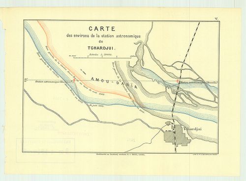
| Title | Carte des environs de la station astronomique de Tchardiui. |
| Main title | Csardzsou város környékén lévő csillagászati állomások térképe 1890 körül. |
7220. Carte des environs de la station astronomique de Tchardjui. ... [B XI c 172]
Institute and Museum of Military History •
B XI c
•
B XI Oroszország
•
B I–XV. Európa

| Title | Carte des environs de la station astronomique de Tchardjui. I. |
| Main title | Plan de la station astronomique de Tchardjui. II. |
| Subject | Csardzsou város környékén lévő csillagászati állomás és környéke 1890 körül. |