721. Usedom Haffküste mit Greifswald Anklam Ueckermünde. Touriste... [B IV c 263]
Institute and Museum of Military History •
B IV c
•
B IV Német birodalom
•
B I–XV. Európa
| Title | Usedom Haffküste mit Greifswald Anklam Ueckermünde. Touristenkarte mit Angaben für Motortouristik und Wassersport. |
722. Mulde–Zschopau mit Karl-Marx-Stadt, Grimma, Freiberg, Annabe... [B IV c 264]
Institute and Museum of Military History •
B IV c
•
B IV Német birodalom
•
B I–XV. Európa
| Title | Mulde–Zschopau mit Karl-Marx-Stadt, Grimma, Freiberg, Annaberg-Buchholz. Touristenkarten mit Angaben für Motortouristik und Wintersport. |
723. Die Gaswirtschaft der Bundesrepublik Deutschland. [B IV c 265]
Institute and Museum of Military History •
B IV c
•
B IV Német birodalom
•
B I–XV. Európa
| Title | Die Gaswirtschaft der Bundesrepublik Deutschland. |
724. Planung Deutsches Verbundnetz. Stand: Januar 1970. Pl. Nr. 1... [B IV c 266]
Institute and Museum of Military History •
B IV c
•
B IV Német birodalom
•
B I–XV. Európa
| Title | Planung Deutsches Verbundnetz. Stand: Januar 1970. Pl. Nr. 1-0191s. |
| Main title | 2 mt.: 1. Rheinisch-Westfälisches Industriegebiet. (Rajna-Vesztfália iparvidéke.) 2. Gebiet am Hochrhein. (Felső-Rajnavidék.) |
| Subject | Németország elektromoshálózata, 1970 januári állapot. |
725. Planung Deutsches Verbundnetz Stand: Januar 1972. Pl. Nr. 1-... [B IV c 266/1]
Institute and Museum of Military History •
B IV c
•
B IV Német birodalom
•
B I–XV. Európa
| Title | Planung Deutsches Verbundnetz Stand: Januar 1972. Pl. Nr. 1-0191u. |
| Main title | 2 mt.: 1. Rheinisch-Westfälisches Industriegebiet. (Rajna-Vesztfália iparvidéke.) 2. Gebiet am Hochrhein. (Felső-Rajna-vidék.) |
| Subject | Németország elektromoshálózata. 1972. januári állapot. |
726. Wanderkarte der Sächsischen Schweiz. – Schramstein-Gebiete. [B IV c 267]
Institute and Museum of Military History •
B IV c
•
B IV Német birodalom
•
B I–XV. Európa
| Title | Wanderkarte der Sächsischen Schweiz. – Schramstein-Gebiete. |
| Main title | 2 mt.: 1. Schrammstein. 2. Affensteine. |
727. Wanderkarte Sächsische Schweiz. [B IV c 268]
Institute and Museum of Military History •
B IV c
•
B IV Német birodalom
•
B I–XV. Európa
| Title | Wanderkarte Sächsische Schweiz. |
| Main title | 1 mt.: Zufahrtswege zur Sächsischen Schweiz |
728. Rheinsberger Landschaft mit Neuruppin, Fürstenberg, Lindow, ... [B IV c 269]
Institute and Museum of Military History •
B IV c
•
B IV Német birodalom
•
B I–XV. Európa
| Title | Rheinsberger Landschaft mit Neuruppin, Fürstenberg, Lindow, Gransee. |
| Main title | 1 mt.: Stadtübersieht von Neuruppin (Neuruppin áttekintő térk.). Rheinsberger és környéke, autótérkép. |
729. Funknavigationskarte. Nordblatt. – Radio Navigation Chart. [B IV c 270]
Institute and Museum of Military History •
B IV c
•
B IV Német birodalom
•
B I–XV. Európa
| Title | Funknavigationskarte. Nordblatt. – Radio Navigation Chart. |
730. Professor W. Liebenow’s Wander-Rad- und Autobomilkarte des O... [B IV c 271]
Institute and Museum of Military History •
B IV c
•
B IV Német birodalom
•
B I–XV. Európa
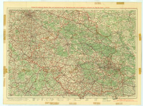
| Title | Professor W. Liebenow’s Wander-Rad- und Autobomilkarte des Oberschlesischen Industriegebietes umfassend den Regierungsbezirk Oppeln. |
| Main title | Felső-Szilézia Opole Kerület turista-út-vasúttérképe. |
731. Übersichtskarte des deutsch-französischen Kriegsschauplatzes... [B IV c 272]
Institute and Museum of Military History •
B IV c
•
B IV Német birodalom
•
B I–XV. Európa
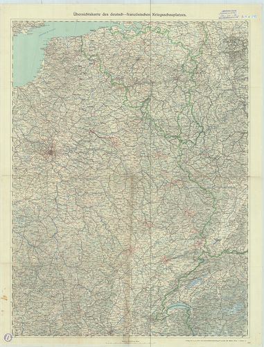
| Title | Übersichtskarte des deutsch-französischen Kriegsschauplatzes. |
| Main title | A német–francia hadszíntér áttekintő térképe úthálózattal. |
732. Reliefkarte der deutsch–russischen Grenzgebiete. Nr. 2. [B IV c 274]
Institute and Museum of Military History •
B IV c
•
B IV Német birodalom
•
B I–XV. Európa
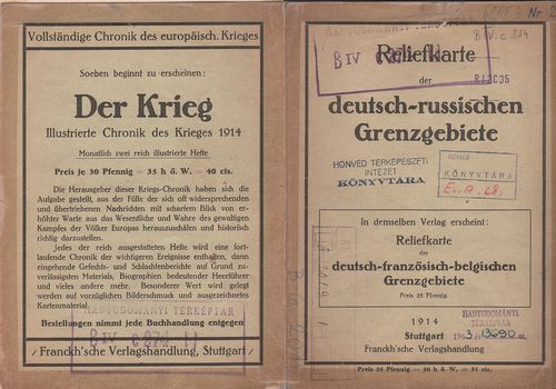
| Title | Reliefkarte der deutsch–russischen Grenzgebiete. Nr. 2. |
| Main title | A német–orosz határvidék madártávlatos térképe 1914-ben. |
733. Garnizon-Karte der Deutschen Armee. [B IV c 275]
Institute and Museum of Military History •
B IV c
•
B IV Német birodalom
•
B I–XV. Európa
| Title | Garnizon-Karte der Deutschen Armee. |
734. 1. Zusammendruck. A. O. K. Süd. [B IV c 276]
Institute and Museum of Military History •
B IV c
•
B IV Német birodalom
•
B I–XV. Európa
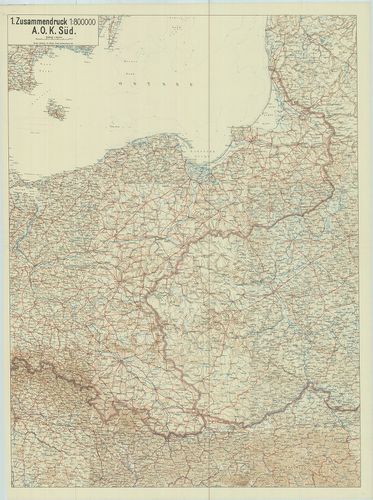
| Title | 1. Zusammendruck. A. O. K. Süd. |
| Main title | [Németország.] Stettin, – Prága (Praha) – Brünn (Brno) – Przemšl – Libau – (Liepäja) közötti terület térképe úthálózattal 1919-ben, össznyomat. |
735. Oberkommando Grenzschutz Nord. [B IV c 277]
Institute and Museum of Military History •
B IV c
•
B IV Német birodalom
•
B I–XV. Európa
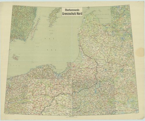
| Title | Oberkommando Grenzschutz Nord. |
| Main title | [Németország.] Stettin (Scecin) – Warszawa – Gotland sziget – Riga-Walk (Valka) közötti terület térképe 1919-ben, úthálózattal. össznyomat. |
736. Der Deutsch-Französische Grenzraum. [B IV c 282]
Institute and Museum of Military History •
B IV c
•
B IV Német birodalom
•
B I–XV. Európa
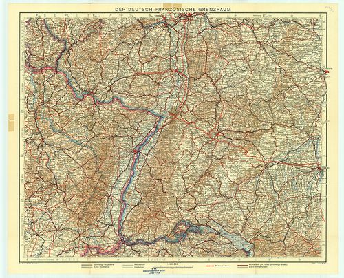
| Title | Der Deutsch-Französische Grenzraum. |
| Main title | A német–francia határvidék autó-vasút-hálózati térképe. |
737. Neue Übersichtskarte des deutsch-französischen Kriegsschaupl... [B IV c 285]
Institute and Museum of Military History •
B IV c
•
B IV Német birodalom
•
B I–XV. Európa
| Title | Neue Übersichtskarte des deutsch-französischen Kriegsschauplatzes. |
738. Neue Übersichtskarte des deutsch-französischen Kriegsschaupl... [B IV c 285/1]
Institute and Museum of Military History •
B IV c
•
B IV Német birodalom
•
B I–XV. Európa
| Title | Neue Übersichtskarte des deutsch-französischen Kriegsschauplatzes. – Hátl.: Übersichtskarte des südlichen Kriegsschauplatzes. |
739. Westlicher Thüringer Wald mit Eisenach, Friedrichroda, Bad S... [B IV c 286]
Institute and Museum of Military History •
B IV c
•
B IV Német birodalom
•
B I–XV. Európa
| Title | Westlicher Thüringer Wald mit Eisenach, Friedrichroda, Bad Salzungen, Schmalkalden. |
740. Wanderkarte Saaletalsperren mit Saalfeld, Pössneck, Schleiz,... [B IV c 287]
Institute and Museum of Military History •
B IV c
•
B IV Német birodalom
•
B I–XV. Európa
| Title | Wanderkarte Saaletalsperren mit Saalfeld, Pössneck, Schleiz, Ziegenrück, Lobenstein. |