741. Die Besatzungszonen in Deutschland u. Österreich. [B IV c 288]
Institute and Museum of Military History •
B IV c
•
B IV Német birodalom
•
B I–XV. Európa
| Title | Die Besatzungszonen in Deutschland u. Österreich. |
742. Besatzungszonen in Deutschland. [B IV c 289]
Institute and Museum of Military History •
B IV c
•
B IV Német birodalom
•
B I–XV. Európa
| Title | Besatzungszonen in Deutschland. |
| Main title | Mt.: Übersicht der Bezatzungszonen. (Megszállási zóna áttekintő térképe.) |
743. Carte des Zones D’Occupation de L’Allemagne et de L’Autriche... [B IV c 290]
Institute and Museum of Military History •
B IV c
•
B IV Német birodalom
•
B I–XV. Európa
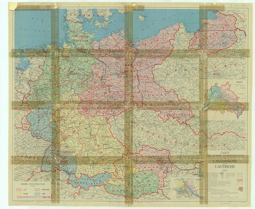
| Title | Carte des Zones D’Occupation de L’Allemagne et de L’Autriche. |
| Main title | 2 mt.: 1. Berlin. 2. Vienne (Bécs). |
| Subject | Németország és Ausztria megszállási zónái 1945-ben. |
744. Verkehrskarte der Deutschen Demokratischen Republik. [B IV c 291]
Institute and Museum of Military History •
B IV c
•
B IV Német birodalom
•
B I–XV. Európa
| Title | Verkehrskarte der Deutschen Demokratischen Republik. |
| Main title | Blatt 1. Rostock, Nr. 101. 1967. Hátl.: 3 térk. 1. Weimar, 2. Schwerin, 3. Rostock. |
| Subject | Blatt 2. Stralsund Nr. V/102. 1969. Hátl.: térk. 1. Stralsund, 2. Neubrandenburg. |
745. Osterzgebirge mit Altenberg, Geising, Frauenstein, Rechenber... [B IV c 292]
Institute and Museum of Military History •
B IV c
•
B IV Német birodalom
•
B I–XV. Európa
| Title | Osterzgebirge mit Altenberg, Geising, Frauenstein, Rechenberg-Bienenmühle, Glashütte, Bad Gottleuba. Wanderkarte mit Angaben für Wintersport. |
746. Westerzgebirge mit Annaberg-Buchholz, Oberwiesenthal, Aue, J... [B IV c 293]
Institute and Museum of Military History •
B IV c
•
B IV Német birodalom
•
B I–XV. Európa
| Title | Westerzgebirge mit Annaberg-Buchholz, Oberwiesenthal, Aue, Johanngeorgenstadt. Wanderkarte mit Angaben für Wintersport. |
747. Darss-Fischland mit Prerow, Ahrenshoop, Zingst, Wustrow, Gra... [B IV c 294]
Institute and Museum of Military History •
B IV c
•
B IV Német birodalom
•
B I–XV. Európa
| Title | Darss-Fischland mit Prerow, Ahrenshoop, Zingst, Wustrow, Graal-Müritz. Wanderkarte mit Angaben für Wassersport. |
| Main title | 3 mt. 1. Prerov. 2. Ostseebad-Ahrenshoop. 3. Zingst. |
748. Auto-Fernstrassen-Karte Deutschlands und Österreichs… Verkeh... [B IV c 295]
Institute and Museum of Military History •
B IV c
•
B IV Német birodalom
•
B I–XV. Európa
| Title | Auto-Fernstrassen-Karte Deutschlands und Österreichs… Verkehrskarte des Deutschen Reiches und Österreichs. |
| Main title | Mt.: Ruhrgebiet. (Ruhrvidék.) |
749. Die gute Verkehrskarte Sachsen–Thüringen–Harz. – Strassenver... [B IV c 296]
Institute and Museum of Military History •
B IV c
•
B IV Német birodalom
•
B I–XV. Európa
| Title | Die gute Verkehrskarte Sachsen–Thüringen–Harz. – Strassenverkehrskarte Sachsen-Thüringen. |
750. Verkehrs- u. Bürokarte Bezirke: Dresden, Leipzig, Karl-Marx-... [B IV c 297]
Institute and Museum of Military History •
B IV c
•
B IV Német birodalom
•
B I–XV. Európa
| Title | Verkehrs- u. Bürokarte Bezirke: Dresden, Leipzig, Karl-Marx-Stadt mit Bezirks und Kreisgrenzen. – Bezirkskarte Dresden, Leipzig, Karl-Marx-Stadt. |
751. Verkehrskarte der Deutsche Demokratische Republik. [B IV c 298]
Institute and Museum of Military History •
B IV c
•
B IV Német birodalom
•
B I–XV. Európa
| Title | Verkehrskarte der Deutsche Demokratische Republik. |
| Main title | Mt.: [Berlin-Európa légiközlekedési térképe.] |
752. Reise und Verkehrskarte. Deutsche Demokratische Republik. [B IV c 299]
Institute and Museum of Military History •
B IV c
•
B IV Német birodalom
•
B I–XV. Európa
| Title | Reise und Verkehrskarte. Deutsche Demokratische Republik. |
753. Verkehrs- und Bürokarte Bezirke Rostock–Schwerin, Neubranden... [B IV c 300]
Institute and Museum of Military History •
B IV c
•
B IV Német birodalom
•
B I–XV. Európa
| Title | Verkehrs- und Bürokarte Bezirke Rostock–Schwerin, Neubrandenburg. – Bezirkskarte Rostock, Schwerin, Neubrandenburg. |
754. Der Bezirk Frankfurt. Geographische Exkursionen. Geographisc... [B IV c 301]
Institute and Museum of Military History •
B IV c
•
B IV Német birodalom
•
B I–XV. Európa
| Title | Der Bezirk Frankfurt. Geographische Exkursionen. Geographische Baustein Neue Reihe, Heft. 9. |
| Main title | 1 térk. mell.: Geomorphologische Übersichtskarte der Bezirke Potsdam, Frankfurt (Oder) und Cottbus. |
| Subject | (Potsdam, Frankfurt (Oder) és Cottbus Geomorfológiai térképe.) |
755. La R. D. A., un pays touristique-Carte d’ensemble pour le to... [B IV c 302]
Institute and Museum of Military History •
B IV c
•
B IV Német birodalom
•
B I–XV. Európa
| Title | La R. D. A., un pays touristique-Carte d’ensemble pour le tourisme, les vacances et la détente. |
756. Jena und Umgebung. Wanderkarte. [B IV c 303]
Institute and Museum of Military History •
B IV c
•
B IV Német birodalom
•
B I–XV. Európa
| Title | Jena und Umgebung. Wanderkarte. |
757. Harz. Spezialkarte für Kraftfahrer. Wanderer und Wintersport... [B IV c 304]
Institute and Museum of Military History •
B IV c
•
B IV Német birodalom
•
B I–XV. Európa
| Title | Harz. Spezialkarte für Kraftfahrer. Wanderer und Wintersportler. |
| Main title | Mt.: Umgebung von Wernigerode (Wernigerode környéke) |
758. Dahlener Heide Wermsdorfer Forst mit Torgau Oschatz Wurzen. ... [B IV c 305]
Institute and Museum of Military History •
B IV c
•
B IV Német birodalom
•
B I–XV. Európa
| Title | Dahlener Heide Wermsdorfer Forst mit Torgau Oschatz Wurzen. Wanderkarte. |
759. Feldberg-Mecklenburg. Wanderkarte. – Die Feldberger Landscha... [B IV c 306]
Institute and Museum of Military History •
B IV c
•
B IV Német birodalom
•
B I–XV. Európa
| Title | Feldberg-Mecklenburg. Wanderkarte. – Die Feldberger Landschaft. |
| Main title | Mt.: [Berlin és északi környéke.] |
760. Neukloster (Mecklenburg) Wanderkarte. [B IV c 307]
Institute and Museum of Military History •
B IV c
•
B IV Német birodalom
•
B I–XV. Európa
| Title | Neukloster (Mecklenburg) Wanderkarte. |
| Main title | Mt.: [Neuklostertől vezető vasút és utak.] |