851. Verkehrskarte Deutsche Demokratische Republik. [B IV c 399]
Institute and Museum of Military History •
B IV c
•
B IV Német birodalom
•
B I–XV. Európa
| Title | Verkehrskarte Deutsche Demokratische Republik. |
852. Német Demokratikus Köztársaság. Német Szövetségi Köztársaság... [B IV c 400]
Institute and Museum of Military History •
B IV c
•
B IV Német birodalom
•
B I–XV. Európa
| Title | Német Demokratikus Köztársaság. Német Szövetségi Köztársaság, Nyugat-Berlin autótérképe. |
853. Német Demokratikus Köztársaság, Nyugat-Berlin autótérképe. [B IV c 401]
Institute and Museum of Military History •
B IV c
•
B IV Német birodalom
•
B I–XV. Európa
| Title | Német Demokratikus Köztársaság, Nyugat-Berlin autótérképe. |
| Main title | 1 mt.: Kishatárforgalom az NDK és NSZK között. |
854. Karte der Vogesen. Blatt XII. Odilienberg-Hohwald. [B IV c 402]
Institute and Museum of Military History •
B IV c
•
B IV Német birodalom
•
B I–XV. Európa
| Title | Karte der Vogesen. Blatt XII. Odilienberg-Hohwald. |
855. Eisenbahn Karte von Deutschland und Nachbarländern. [B IV c 403]
Institute and Museum of Military History •
B IV c
•
B IV Német birodalom
•
B I–XV. Európa
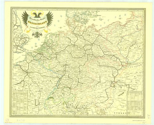
| Title | Eisenbahn Karte von Deutschland und Nachbarländern. |
| Main title | Németország és a környező területek vasúttérképe 1849-ből. |
856. Neuste-Reise-Karte von Deutschland und der angrenzenden Länd... [B IV c 404]
Institute and Museum of Military History •
B IV c
•
B IV Német birodalom
•
B I–XV. Európa
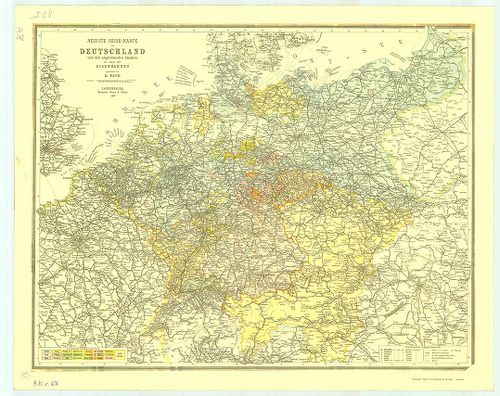
| Title | Neuste-Reise-Karte von Deutschland und der angrenzenden Ländern mit Angabe aller Eisenbahnen. |
| Main title | Németország és a környező országok útitérképe, valamennyi vasútvonal feltüntetésével 1899-ből. |
857. Die Verwaltungsbezirke des Deutschehn Reichs nach dem Stand ... [B IV c 405]
Institute and Museum of Military History •
B IV c
•
B IV Német birodalom
•
B I–XV. Európa
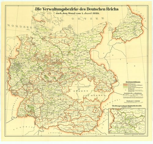
| Title | Die Verwaltungsbezirke des Deutschehn Reichs nach dem Stand vom 1. Juni 1939. |
| Main title | Németország közigazgatási beosztása 1939. jún. 1-jétől. |
858. Luftverkehrkarte des Deutschen Reiches. [B IV c 406]
Institute and Museum of Military History •
B IV c
•
B IV Német birodalom
•
B I–XV. Európa
| Title | Luftverkehrkarte des Deutschen Reiches. |
| Main title | A Német Birodalom légiforgalmi térképe. |
859. Deutschland-Karte. [B IV c 407]
Institute and Museum of Military History •
B IV c
•
B IV Német birodalom
•
B I–XV. Európa
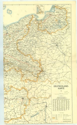
| Title | Deutschland-Karte. |
| Main title | 1 mt.: Memel vidéke. |
| Subject | Németország térképe 1939-ből. A kész és a tervezett autópályákkal. (Alaptérkép 1935. Helyesbítése 1939. január.) |
860. Németország. [B IV c 409]
Institute and Museum of Military History •
B IV c
•
B IV Német birodalom
•
B I–XV. Európa
| Title | Németország. |
861. Militair-Karte von Deutschland. [B IV c 410]
Institute and Museum of Military History •
B IV c
•
B IV Német birodalom
•
B I–XV. Európa
| Title | Militair-Karte von Deutschland. |
862. Militair Charte über den Schwartzwald. [B IV c 411]
Institute and Museum of Military History •
B IV c
•
B IV Német birodalom
•
B I–XV. Európa
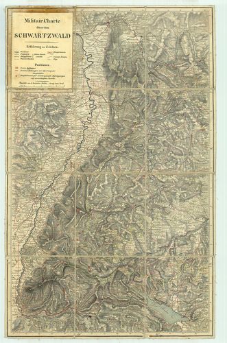
| Title | Militair Charte über den Schwartzwald. |
| Main title | A Fekete-erdő környékének katonai térképe. |
863. Németország (Keleti tartomány) – autótérkép. [B IV c 412]
Institute and Museum of Military History •
B IV c
•
B IV Német birodalom
•
B I–XV. Európa
| Title | Németország (Keleti tartomány) – autótérkép. |
864. Deutschland - Németország. [B IV c 413]
Institute and Museum of Military History •
B IV c
•
B IV Német birodalom
•
B I–XV. Európa
| Title | Deutschland - Németország. |
865. Topographische Karte 1:100 000. C 5914. Wiesbaden. [B IV c 414]
Institute and Museum of Military History •
B IV c
•
B IV Német birodalom
•
B I–XV. Európa
| Title | Topographische Karte 1:100 000. C 5914. Wiesbaden. |
| Main title | Németország topográfiai térképe 1:100 000 ma. C 5914. Wiesbaden szelvény. |
866. Németország autótérképe. [B IV c 415]
Institute and Museum of Military History •
B IV c
•
B IV Német birodalom
•
B I–XV. Európa
| Title | Németország autótérképe. |
867. Bundesrepublik. Der Grosse Autoatlas. 1980. [B IV c 416]
Institute and Museum of Military History •
B IV c
•
B IV Német birodalom
•
B I–XV. Európa
| Title | Bundesrepublik. Der Grosse Autoatlas. 1980. |
| Main title | 1 mt.: Autoreisezüge. |
868. Németország autótérképe. [B IV c 417]
Institute and Museum of Military History •
B IV c
•
B IV Német birodalom
•
B I–XV. Európa
| Title | Németország autótérképe. |
869. Bodensee. [B IV c 418]
Institute and Museum of Military History •
B IV c
•
B IV Német birodalom
•
B I–XV. Európa
| Title | Bodensee. |
870. Deutsche Detailkarte. (1.) Schleswieg-Holstein; Hamburg-Brem... [B IV c 419]
Institute and Museum of Military History •
B IV c
•
B IV Német birodalom
•
B I–XV. Európa
| Title | Deutsche Detailkarte. (1.) Schleswieg-Holstein; Hamburg-Bremen. (2.) Mecklenburg Vorpommen; Brandenburg-Nord. (3.) Niedersachsen nordwest. (4.) Niedersachsen südost. (7.) Nordrhein-Westfalen. (8.) Hessen. |
871. Deutschland. [B IV c 420]
Institute and Museum of Military History •
B IV c
•
B IV Német birodalom
•
B I–XV. Európa
| Title | Deutschland. |
872. WestlicheRhein-Main-Gebeit ca. 50 km um Frankfurt. Umgebungs... [B IV c 421]
Institute and Museum of Military History •
B IV c
•
B IV Német birodalom
•
B I–XV. Európa
| Title | WestlicheRhein-Main-Gebeit ca. 50 km um Frankfurt. Umgebungskarte. |
873. Rhön Wanderkarte. [B IV c 422]
Institute and Museum of Military History •
B IV c
•
B IV Német birodalom
•
B I–XV. Európa
| Title | Rhön Wanderkarte. |
874. [Németország megszállási zónáinak térképe] [B IV c 423]
Institute and Museum of Military History •
B IV c
•
B IV Német birodalom
•
B I–XV. Európa
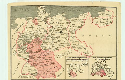
| Title | [Németország megszállási zónáinak térképe] |
875. Tegernsee-Schliersee. [B IV c 424]
Institute and Museum of Military History •
B IV c
•
B IV Német birodalom
•
B I–XV. Európa
| Title | Tegernsee-Schliersee. |
876. Bautzen und Umgebung. [B IV c 425]
Institute and Museum of Military History •
B IV c
•
B IV Német birodalom
•
B I–XV. Európa
| Title | Bautzen und Umgebung. |
| Main title | Bautzen és környéke turistatérkép (Németország). |
877. Hessen, Deutsche Strassenkarte. [B IV c 426]
Institute and Museum of Military History •
B IV c
•
B IV Német birodalom
•
B I–XV. Európa
| Title | Hessen, Deutsche Strassenkarte. |
878. Nord-Bayern, Deutsche Strassenkarte. [B IV c 427]
Institute and Museum of Military History •
B IV c
•
B IV Német birodalom
•
B I–XV. Európa
| Title | Nord-Bayern, Deutsche Strassenkarte. |
879. Weser-Ems Ostfriesland, Deutsche Strassenkarte. [B IV c 428]
Institute and Museum of Military History •
B IV c
•
B IV Német birodalom
•
B I–XV. Európa
| Title | Weser-Ems Ostfriesland, Deutsche Strassenkarte. |
880. Nordrhein-Westfalen. [B IV c 429]
Institute and Museum of Military History •
B IV c
•
B IV Német birodalom
•
B I–XV. Európa
| Title | Nordrhein-Westfalen. |
881. Elsass Lothringen. [B IV c 430]
Institute and Museum of Military History •
B IV c
•
B IV Német birodalom
•
B I–XV. Európa
| Title | Elsass Lothringen. |
| Main title | Elzász-Lotaringia autótérképe (Németország). |
882. Autokarte Südwestdeutschland [B IV c 431]
Institute and Museum of Military History •
B IV c
•
B IV Német birodalom
•
B I–XV. Európa
| Title | Autokarte Südwestdeutschland |
883. Wanderkarte Saabach - Hinterglemm [B IV c 432]
Institute and Museum of Military History •
B IV c
•
B IV Német birodalom
•
B I–XV. Európa
| Title | Wanderkarte Saabach - Hinterglemm |
884. Brandenburg Havel. [B IV c 433]
Institute and Museum of Military History •
B IV c
•
B IV Német birodalom
•
B I–XV. Európa
| Title | Brandenburg Havel. |
885. Ostseeküste. [B IV c 434]
Institute and Museum of Military History •
B IV c
•
B IV Német birodalom
•
B I–XV. Európa
| Title | Ostseeküste. |
886. Neuss mit Mönchengladbach. [B IV c 435]
Institute and Museum of Military History •
B IV c
•
B IV Német birodalom
•
B I–XV. Európa
| Title | Neuss mit Mönchengladbach. |
887. Bersenbrücker Land. [B IV c 436]
Institute and Museum of Military History •
B IV c
•
B IV Német birodalom
•
B I–XV. Európa
| Title | Bersenbrücker Land. |
888. Unteres Altmühltal - Regensburg. [B IV c 437]
Institute and Museum of Military History •
B IV c
•
B IV Német birodalom
•
B I–XV. Európa
| Title | Unteres Altmühltal - Regensburg. |
889. Umgebung von Berlin. [B IV c 438]
Institute and Museum of Military History •
B IV c
•
B IV Német birodalom
•
B I–XV. Európa
| Title | Umgebung von Berlin. |
890. Autokarte. [B IV c 439]
Institute and Museum of Military History •
B IV c
•
B IV Német birodalom
•
B I–XV. Európa
| Title | Autokarte. |
891. Olex Autokarte Süddeutschland. [B IV c 440]
Institute and Museum of Military History •
B IV c
•
B IV Német birodalom
•
B I–XV. Európa
| Title | Olex Autokarte Süddeutschland. |
892. Bundesrepublik Deutschland, Deutche Demokratische Republik. [B IV c 441]
Institute and Museum of Military History •
B IV c
•
B IV Német birodalom
•
B I–XV. Európa
| Title | Bundesrepublik Deutschland, Deutche Demokratische Republik. |
893. Bundesrepublik Deutschland, Deutche Demokratische Republik. [B IV c 442]
Institute and Museum of Military History •
B IV c
•
B IV Német birodalom
•
B I–XV. Európa
| Title | Bundesrepublik Deutschland, Deutche Demokratische Republik. |
894. Campingkarte der DDR. [B IV c 443]
Institute and Museum of Military History •
B IV c
•
B IV Német birodalom
•
B I–XV. Európa
| Title | Campingkarte der DDR. |
895. Berchtesgaden. [B IV c 445]
Institute and Museum of Military History •
B IV c
•
B IV Német birodalom
•
B I–XV. Európa
| Title | Berchtesgaden. |
896. Karte der Verkehrswege 1200 Meilen um Berlin für Rad- und Au... [B IV c 446]
Institute and Museum of Military History •
B IV c
•
B IV Német birodalom
•
B I–XV. Európa
| Title | Karte der Verkehrswege 1200 Meilen um Berlin für Rad- und Auto-Fahrer. |