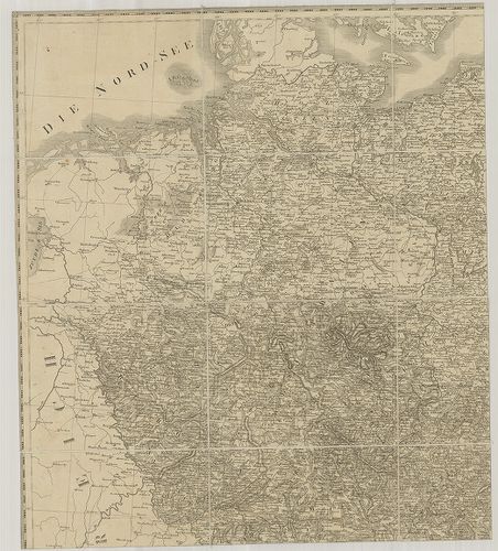
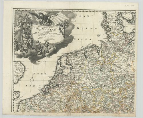
1. Novus et Accuratus Utriusque Germaniae Typus. [B IV a 2]
Institute and Museum of Military History •
B IV a
•
B IV Német birodalom
•
B I–XV. Európa
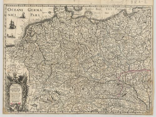
| Title | Novus et Accuratus Utriusque Germaniae Typus. |
| Main title | Németország általános térképe 1633-ban. |
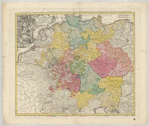
2. Carte Générale de l’Empire D’Allemagne. [B IV a 3/3]
Institute and Museum of Military History •
B IV a
•
B IV Német birodalom
•
B I–XV. Európa
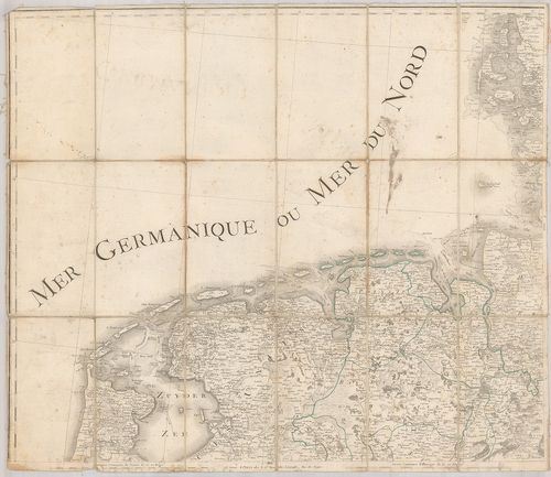
| Title | Carte Générale de l’Empire D’Allemagne. |
| Main title | A Német Birodalom áttekintő térképe 1801-ben. |
3. Special Karte von der Neumark und den angrenzenden Ländern. ... [B IV a 4]
Institute and Museum of Military History •
B IV a
•
B IV Német birodalom
•
B I–XV. Európa
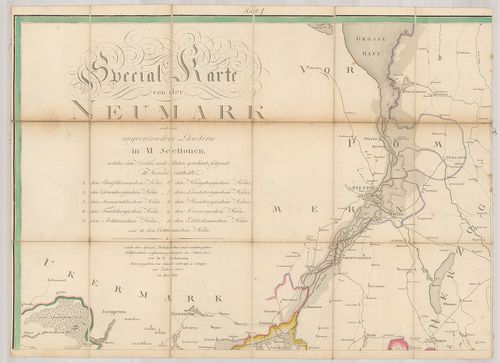
| Title | Special Karte von der Neumark und den angrenzenden Ländern. 1805. |
| Main title | Brandenburg őrgrófság, Odera jobbparti része (Neumark) részletes térkép az új kerületi határokkal, erdők, utak, települések, stb. megjelölésével 1805-ben. |
4. Charte von Deutschland. Nach den letzten Friedens Schlüssen ... [B IV a 5]
Institute and Museum of Military History •
B IV a
•
B IV Német birodalom
•
B I–XV. Európa
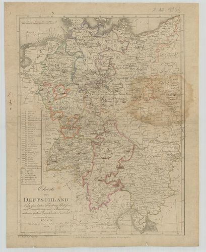
| Title | Charte von Deutschland. Nach den letzten Friedens Schlüssen und Conwentionen mit Benützung mehrerer guten Specialkarten beabeitet. |
| Main title | Németország általános térképe 1808-ban a tartományhatárok megjelölésével. |
5. General Charte von Teutschland in vier Blättern… [B IV a 23/1]
Institute and Museum of Military History •
B IV a
•
B IV Német birodalom
•
B I–XV. Európa
| Title | General Charte von Teutschland in vier Blättern… |
| Main title | Németország általános térképe 1810-ben. |
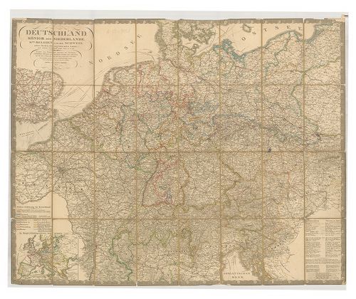
6. Deutschland, Königr. der Niederlande, Königr. Belgium und di... [B IV a 23/3]
Institute and Museum of Military History •
B IV a
•
B IV Német birodalom
•
B I–XV. Európa
| Title | Deutschland, Königr. der Niederlande, Königr. Belgium und die Schweiz nebst Theilen der angränzenden Länder. |
| Main title | 2 mt.: 1. Die Hauptverbindungsstrassen durch Europa. (Európa szárazföldi és tengeri összekötő főútvonalainak térképe.) 2. Regirungs-Bezirk Gumbinnen in Ost-Preussen. (Kelet-Poroszország kormányzósági kerülete.)Németország, Hollandia, Belgium, Svájc általános és úthálózati térképe a szomszédos országok egy részével 1850-ben. |
7. Duetschland, Königr. der Niederlande, Kgr. Belgium und die S... [B IV a 23/3/a]
Institute and Museum of Military History •
B IV a
•
B IV Német birodalom
•
B I–XV. Európa
| Title | Duetschland, Königr. der Niederlande, Kgr. Belgium und die Schweiz, nebst Theilen der angränzenden Länder. |
| Main title | 2 mt.: 1. Die Hauptverbindungsstrassen durch Europa. (Euróa szárazföldi és tengeri összekötő főútvonalainak térképe.) 2. Regigungs-Bezirk Gumbinnen in Ostpreussen. (Kelet-Poroszország kormányzósági kerülete.)Németország, Hollandia, Belgium, Svájc úthálózati térképe a szomszédos országok egy-egy részével 1860-ben. |
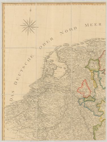
8. Karte von West Deutschland, Nord-Ost Frankreich, Süd Holland... [B IV a 23/3/b]
Institute and Museum of Military History •
B IV a
•
B IV Német birodalom
•
B I–XV. Európa
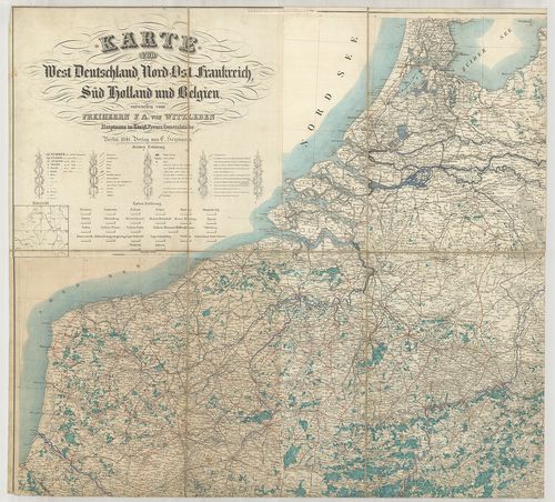
| Title | Karte von West Deutschland, Nord-Ost Frankreich, Süd Holland und Belgien. |
| Main title | Nyugat-Németország, Északkelet-Franciaország, Dél-Hollandia és Belgium áttekintő térképe 1841-ben. |
9. Mappa Geographica summo labore accurate et novissime exarata... [B IV a 25]
Institute and Museum of Military History •
B IV a
•
B IV Német birodalom
•
B I–XV. Európa
| Title | Mappa Geographica summo labore accurate et novissime exarata, exhibens Circulus Aliquot Germaniae, Praesertim illos ubi Bellum nunc Geritur. |
| Main title | Németország általános térképe a környező államokkal 1759-ben. |
10. Karte von Deutschland. [B IV a 26]
Institute and Museum of Military History •
B IV a
•
B IV Német birodalom
•
B I–XV. Európa
| Title | Karte von Deutschland. |
| Main title | Németország térképe 1796-ban. |
11. Tabula Novissima Totius Germaniae. [B IV a 27]
Institute and Museum of Military History •
B IV a
•
B IV Német birodalom
•
B I–XV. Európa
| Title | Tabula Novissima Totius Germaniae. |
| Main title | Németország térképe. |
12. Karte von Deutschland dem Koenigr. der Niederlande dem Kgr. ... [B IV a 30]
Institute and Museum of Military History •
B IV a
•
B IV Német birodalom
•
B I–XV. Európa
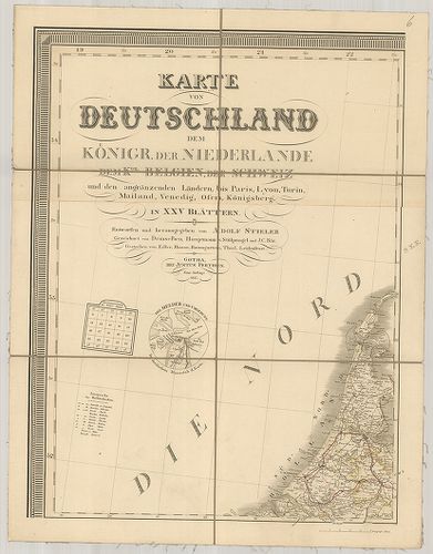
| Title | Karte von Deutschland dem Koenigr. der Niederlande dem Kgr. Belgien, der Schweiz und den angränzenden Ländern, bis Paris, Lyon, Turin, Mailand, Vendig, Ofen, Königsberg, in XXV Blättern. |
| Main title | Németország, Hollandia, Belgium, Svájc és a szomszédos országok térképe. |
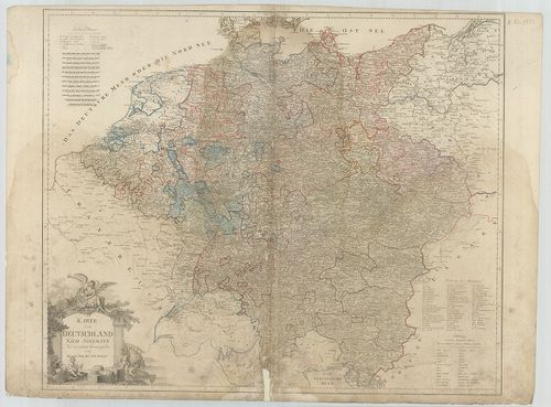
13. Karte von Deutschland dem Koenigr. der Niederlande und der S... [B IV a 30/1]
Institute and Museum of Military History •
B IV a
•
B IV Német birodalom
•
B I–XV. Európa
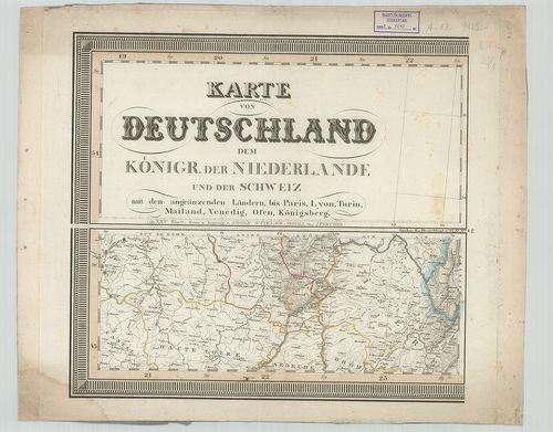
| Title | Karte von Deutschland dem Koenigr. der Niederlande und der Schweiz mit angränzenden Ländern, bis Paris, Lyon, Turin, Mailand, Vendig, Ofen, Königsberg. |
| Main title | Németország, Hollandia, Belgium, Svájc és a szomszédos országok térképe. |
14. Neueste Carte von Deutschland. – L’Allemagne suivant les der... [B IV a 30/2]
Institute and Museum of Military History •
B IV a
•
B IV Német birodalom
•
B I–XV. Európa
| Title | Neueste Carte von Deutschland. – L’Allemagne suivant les derniers traités de paix de Luneville. |
| Main title | Németország térképe a lunevillei békekötés (1801) után. |
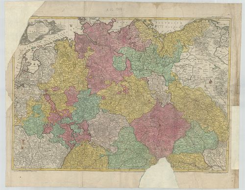
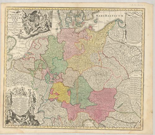
15. Imperium Romano-Germanicum in suos Circulos Electorat. [B IV a 31]
Institute and Museum of Military History •
B IV a
•
B IV Német birodalom
•
B I–XV. Európa
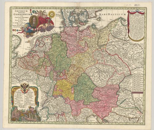
| Title | Imperium Romano-Germanicum in suos Circulos Electorat. |
| Main title | A Német-Római Birodalom tartományainak és választófejedelemségeinek általános térképe 1726-ban. |
16. Germania Magna. [B IV a 32]
Institute and Museum of Military History •
B IV a
•
B IV Német birodalom
•
B I–XV. Európa
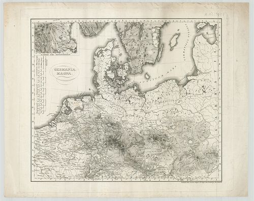
| Title | Germania Magna. |
| Main title | Németország térképe. |
17. Germania Ecclesiastica seu Imperium Romano Germanicum. [B IV a 33]
Institute and Museum of Military History •
B IV a
•
B IV Német birodalom
•
B I–XV. Európa
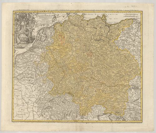
| Title | Germania Ecclesiastica seu Imperium Romano Germanicum. |
| Main title | A Német-Római Birodalom egyházi beosztású térképe 1741-ben. |
18. Germania Benedictina. [B IV a 34]
Institute and Museum of Military History •
B IV a
•
B IV Német birodalom
•
B I–XV. Európa
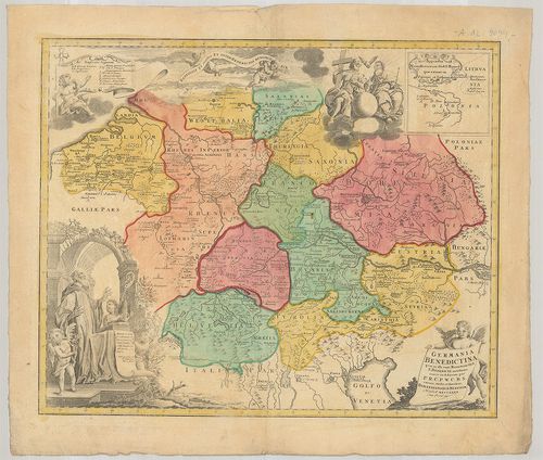
| Title | Germania Benedictina. |
| Main title | Mt.: Appendix Monasteriorum Ord. S. Bened. que extant in Polonia et Lithvania. (A Szent Benedek-rend kolostorai Lengyelországban és Litvániában.)Németország térképe a Szent Benedek-rend helyeivel, 1732-ben. |
19. Imperii Romano-Germanici in suos Status et Circulos Divisi T... [B IV a 35]
Institute and Museum of Military History •
B IV a
•
B IV Német birodalom
•
B I–XV. Európa
| Title | Imperii Romano-Germanici in suos Status et Circulos Divisi Tabula Generalis in Usus Iuventutis erudiendae accommodata. |
| Main title | A Német-Római Birodalom tartományainak általános térképe 1741-ben. |
20. Imperium Romano-Germanicum in suos Circulos Elektorat. [B IV a 36]
Institute and Museum of Military History •
B IV a
•
B IV Német birodalom
•
B I–XV. Európa
| Title | Imperium Romano-Germanicum in suos Circulos Elektorat. |
| Main title | A Német-Római Birodalom térképe. |