61. Topographische Übersichtskarte des Deutschen Reiches. [B IV a 64]
Institute and Museum of Military History •
B IV a
•
B IV Német birodalom
•
B I–XV. Európa
| Title | Topographische Übersichtskarte des Deutschen Reiches. |
62. Das Nördliche Deutschland oder die Länder zwischen der Oder ... [B IV a 66]
Institute and Museum of Military History •
B IV a
•
B IV Német birodalom
•
B I–XV. Európa

| Title | Das Nördliche Deutschland oder die Länder zwischen der Oder und dem Rheine. |
| Main title | Észak-Németország térképe az Odera és a Rajna közötti tartományokkal 1815-ben. |
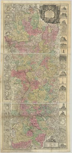
63. Bayern, Württemberg und Baden nebst betraechtlichen Theilen ... [B IV a 68]
Institute and Museum of Military History •
B IV a
•
B IV Német birodalom
•
B I–XV. Európa
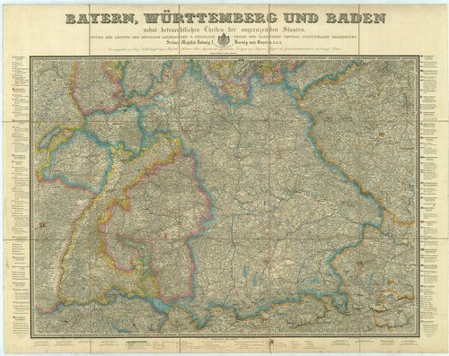
| Title | Bayern, Württemberg und Baden nebst betraechtlichen Theilen der angrenzenden Staaten. |
| Main title | Bajorország, Württemberg és Baden térképe 1847-ben. Tartományi és kerületi beosztással. |
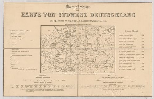
64. [Karte] von Südwest-Deutschland und dem Alpenlande. [B IV a 69]
Institute and Museum of Military History •
B IV a
•
B IV Német birodalom
•
B I–XV. Európa
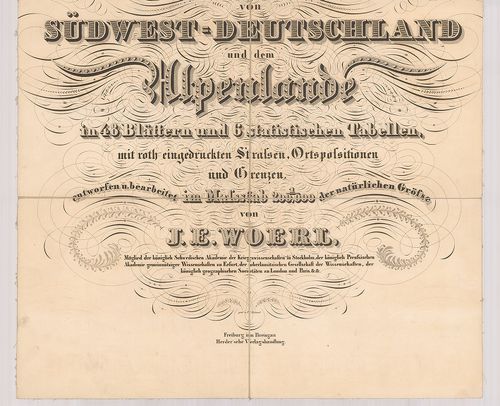
| Title | [Karte] von Südwest-Deutschland und dem Alpenlande. |
| Main title | Délnyugat-Németország általános térképe. |
65. Alsatia Superior una cum Suntgovia. [B IV a 70]
Institute and Museum of Military History •
B IV a
•
B IV Német birodalom
•
B I–XV. Európa
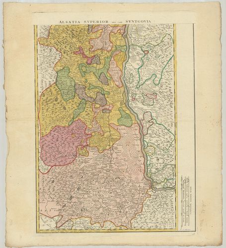
| Title | Alsatia Superior una cum Suntgovia. |
| Main title | Felső-Elzász és Sundgau térképe. |
66. General-Karte vom Süd Westlichen Deutschland. [B IV a 71]
Institute and Museum of Military History •
B IV a
•
B IV Német birodalom
•
B I–XV. Európa
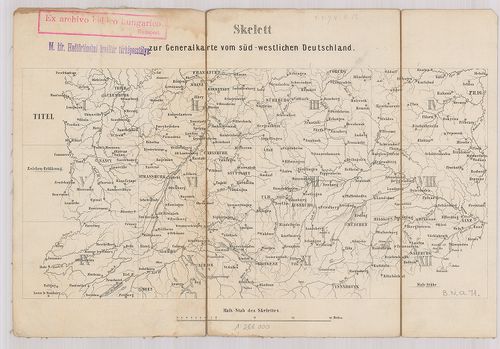
| Title | General-Karte vom Süd Westlichen Deutschland. |
| Main title | Dél-Nyugat Németország általános térképe 1865-ben. |
67. Carte Topographique de L’Ancienne Souabe et D’Une Portion de... [B IV a 72]
Institute and Museum of Military History •
B IV a
•
B IV Német birodalom
•
B I–XV. Európa
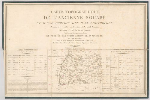
| Title | Carte Topographique de L’Ancienne Souabe et D’Une Portion de Pays Limitrophes. |
| Main title | Svábföld térképe 1818-ban. |
68. Südwest-Deutschland bis zu den Alpen mit Theilen angrenzende... [B IV a 72/1]
Institute and Museum of Military History •
B IV a
•
B IV Német birodalom
•
B I–XV. Európa
| Title | Südwest-Deutschland bis zu den Alpen mit Theilen angrenzenden Länder in 25 Blättern und einem Übersichtsblatt. |
| Main title | Délnyugat-Németország térképe 1867-ben. |
69. Der Preussische Staat und das Deutsche Reich. [B IV a 73]
Institute and Museum of Military History •
B IV a
•
B IV Német birodalom
•
B I–XV. Európa
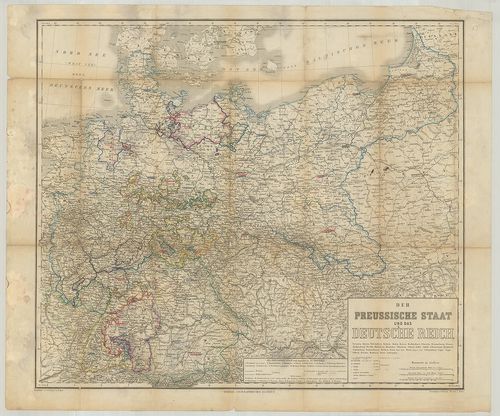
| Title | Der Preussische Staat und das Deutsche Reich. |
| Main title | A Porosz Állam és a Német Birodalom térképe a tartományok kiemelésével. |
70. Synopsis Circuli Rhenani Inferioris, Sive Electoratum Rheni ... [B IV a 77]
Institute and Museum of Military History •
B IV a
•
B IV Német birodalom
•
B I–XV. Európa
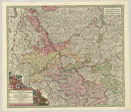
| Title | Synopsis Circuli Rhenani Inferioris, Sive Electoratum Rheni exhibens Archi-Episcopatum Moguntinum, Coloniensem, Trevirensem et Palatinatum Rheni. |
| Main title | Németország: Mainz-i, Köln-i, Trier-i Érsekség, Rajna-Pfalz és a környékbeli grófságok térképe. |
71. Carte Nouvelle de L’Archevesché et Eslectorat de Cologne. – ... [B IV a 77/1]
Institute and Museum of Military History •
B IV a
•
B IV Német birodalom
•
B I–XV. Európa
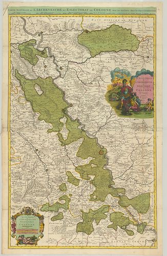
| Title | Carte Nouvelle de L’Archevesché et Eslectorat de Cologne. – Haute Partie de l’Archevesché et Eslectorat de Cologne. – La Basse Partie de L’Archevesché et Eslectorat de Cologne. |
| Main title | A Köln-i Érsekség és választófejedelemség általános térképe. |
72. Post und Reise Charte von Deutschland. [B IV a 78]
Institute and Museum of Military History •
B IV a
•
B IV Német birodalom
•
B I–XV. Európa
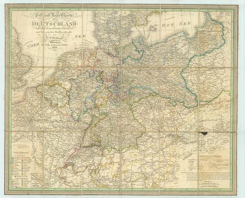
| Title | Post und Reise Charte von Deutschland. |
| Main title | Németország posta és útvonal-hálózat térképe 1838-ban. |
73. Rhenus per tres Tabellas delineatus cum finitintis fortifica... [B IV a 79]
Institute and Museum of Military History •
B IV a
•
B IV Német birodalom
•
B I–XV. Európa
| Title | Rhenus per tres Tabellas delineatus cum finitintis fortificatis Urbibus, Arcibus In Forma et aliis Territoriis ad Rhenum adjacentibus, cumq variis utilissimis Annotationibus. |
| Main title | A Rajna vidék tartományainak térképe. |
74. Theatrum Belli Serenissimae Domus Austriae, Contra Gallos, C... [B IV a 80]
Institute and Museum of Military History •
B IV a
•
B IV Német birodalom
•
B I–XV. Európa
| Title | Theatrum Belli Serenissimae Domus Austriae, Contra Gallos, Confine Limitibus Sacri Romani Imperii et Belgii. Seu Tabula Geographica Cursus Rheni… – Neuester Schauplatz des Krieges an dem Ober Rhein und in denen Niederlanden… |
75. Theatre de la Guerra sur le Rhin, sur la Meuse, sur la Mosel... [B IV a 81]
Institute and Museum of Military History •
B IV a
•
B IV Német birodalom
•
B I–XV. Európa

| Title | Theatre de la Guerra sur le Rhin, sur la Meuse, sur la Moselle, et sur le Neckre. – Le Cours du Rhin. |
| Main title | A Rajnavidék: Rajna–Maas–Moselle és a Neckar vidék térképe 1744-ben. |
76. Carte des Cercles de Haut et du Bas Rhin. [B IV a 81/1]
Institute and Museum of Military History •
B IV a
•
B IV Német birodalom
•
B I–XV. Európa
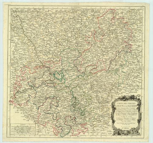
| Title | Carte des Cercles de Haut et du Bas Rhin. |
| Main title | Rajnavidék általános térképe 1753-ban. |
77. Comitatus Meursensis et Annexarum Dinastiarum. [B IV a 81/2]
Institute and Museum of Military History •
B IV a
•
B IV Német birodalom
•
B I–XV. Európa
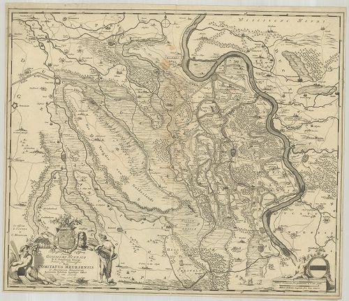
| Title | Comitatus Meursensis et Annexarum Dinastiarum. |
| Main title | A Moers-i grófság térképe. |
78. Comitatus Meursensis et Annexarum Dinastiarum. [B IV a 81/3]
Institute and Museum of Military History •
B IV a
•
B IV Német birodalom
•
B I–XV. Európa
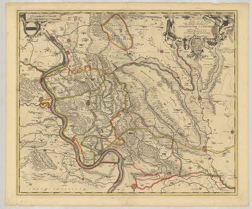
| Title | Comitatus Meursensis et Annexarum Dinastiarum. |
| Main title | A Moers-i grófság térképe. |
79. Theatre de la Guerra sur le Rhin, Moeselle, Mayn le Necker, ... [B IV a 81/4]
Institute and Museum of Military History •
B IV a
•
B IV Német birodalom
•
B I–XV. Európa
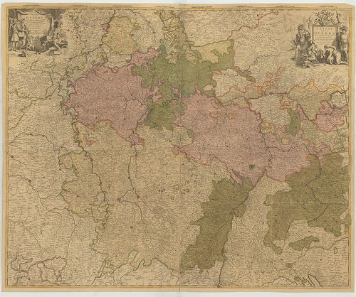
| Title | Theatre de la Guerra sur le Rhin, Moeselle, Mayn le Necker, Meuse. |
| Main title | A Rajnavidék: Rajna–Moselle–Maina–Neckar–Maas közti terület áttekintő térképe. |
80. Partie Orientale du Palatinat et Eslectorat du Rhein. Les Ev... [B IV a 81/5]
Institute and Museum of Military History •
B IV a
•
B IV Német birodalom
•
B I–XV. Európa
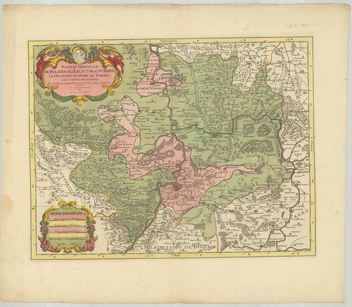
| Title | Partie Orientale du Palatinat et Eslectorat du Rhein. Les Evesches de Spire, de Wormes et le Comte de Linange. |
| Main title | A Pfalz-i választófejedelemség keleti része, valamint a Speyer–Worms-püspökség Leiningen grófság térképe. |