41. Ammersee, Würmsee und Isartal. [B IV b 139]
Institute and Museum of Military History •
B IV b
•
B IV Német birodalom
•
B I–XV. Európa
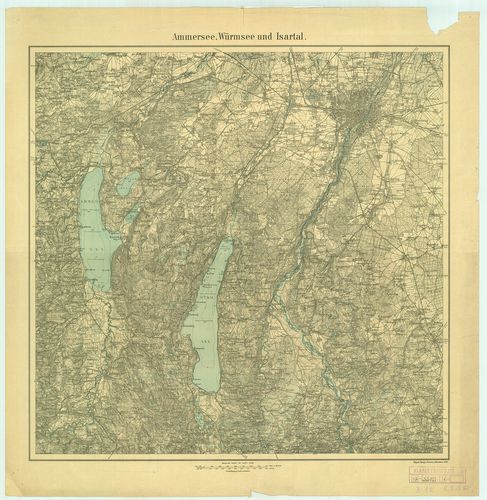
| Title | Ammersee, Würmsee und Isartal. |
| Main title | Az Ammer-tó, Würm-tó és az Isarvölgy topográfiai térképe 1923-ban. |
42. Der Königssee und Umgebung. [B IV b 140]
Institute and Museum of Military History •
B IV b
•
B IV Német birodalom
•
B I–XV. Európa
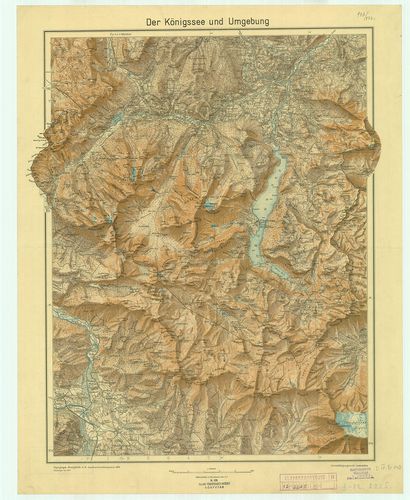
| Title | Der Königssee und Umgebung. |
| Main title | A Königs-tó és vidékének topográfiai térképe 1935-ben. |
43. Tegernsee, Schliersee. [B IV b 141]
Institute and Museum of Military History •
B IV b
•
B IV Német birodalom
•
B I–XV. Európa
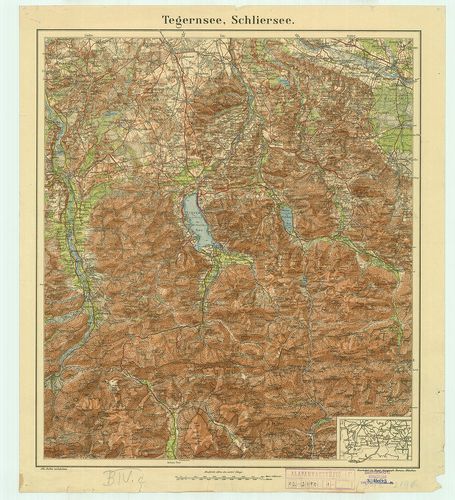
| Title | Tegernsee, Schliersee. |
| Main title | Mt.: [München és Salzburg környéke.] |
| Subject | A Tegern-tó és Schlier-tó vidékének topográfiai térképe. |
44. Topographische Karte des Rheinstromes und seiner beiderseiti... [B IV b 142/2]
Institute and Museum of Military History •
B IV b
•
B IV Német birodalom
•
B I–XV. Európa
| Title | Topographische Karte des Rheinstromes und seiner beiderseitigen Ufer von Hueningen bis Lauterburg… 1814–1815. |
45. Topographische Karte der Gegend zwischen der Donau, Abens un... [B IV b 143]
Institute and Museum of Military History •
B IV b
•
B IV Német birodalom
•
B I–XV. Európa
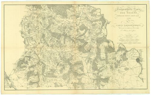
| Title | Topographische Karte der Gegend zwischen der Donau, Abens und Iser. – Carte Topographique du Pays Entre le Danube, l’Abens et l’Iser. |
| Main title | A Duna, Abens és Isar közötti terület topográfiai térképe 1811-ben. |
46. Übersichtskarte des Mecklenburgischen Seeengebietes und sein... [B IV b 146]
Institute and Museum of Military History •
B IV b
•
B IV Német birodalom
•
B I–XV. Európa
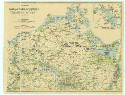
| Title | Übersichtskarte des Mecklenburgischen Seeengebietes und seiner Verbindungen mit Ostsee, Elbe, Havel, Oder für Schiffahrt und Wassersport. |
| Main title | Mt.: Karte vom Müritz-See. (A Müritz-tó térképe.) |
| Subject | A Mecklenburg-i-tóvidék áttekintő térképe. |
47. Bayerisches Hochland und Nordtirol, westlicher Teil. [B IV b 147]
Institute and Museum of Military History •
B IV b
•
B IV Német birodalom
•
B I–XV. Európa
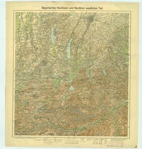
| Title | Bayerisches Hochland und Nordtirol, westlicher Teil. |
| Main title | A Bajor Felvidék és Észak-Tirol térképe, 1922-ben. (Nyugati rész.) |
48. Karte von dem Grossherzogthume Hessen und den angränzenden L... [B IV b 148]
Institute and Museum of Military History •
B IV b
•
B IV Német birodalom
•
B I–XV. Európa
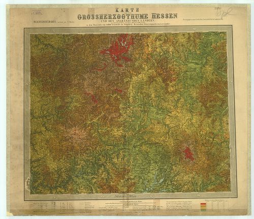
| Title | Karte von dem Grossherzogthume Hessen und den angränzenden Ländern. Hoehenschichten-Karte. |
| Main title | A Hessen-i Nagyhercegség hipszometrikus térképe. |
49. Höhenschichten-Karte v. Byern. Bl. 7, 8, 9. [B IV b 155]
Institute and Museum of Military History •
B IV b
•
B IV Német birodalom
•
B I–XV. Európa
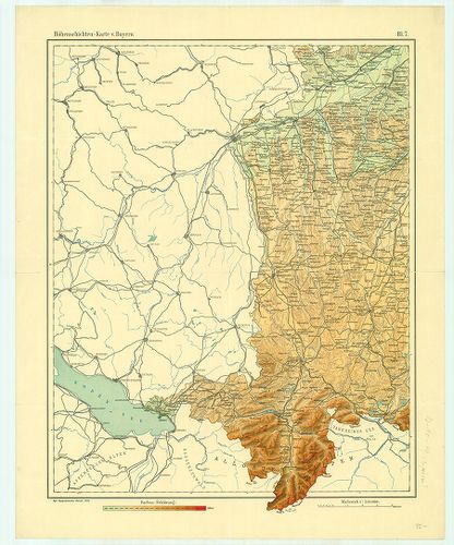
| Title | Höhenschichten-Karte v. Byern. Bl. 7, 8, 9. |
| Main title | Bajorország hipszometrikus térképe 1906–1923-ban. |
50. Deutschland. [B IV b 156]
Institute and Museum of Military History •
B IV b
•
B IV Német birodalom
•
B I–XV. Európa

| Title | Deutschland. |
| Main title | Németország. |
51. Geologische Karte von Deutschland. [B IV b 157]
Institute and Museum of Military History •
B IV b
•
B IV Német birodalom
•
B I–XV. Európa
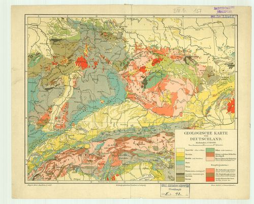
| Title | Geologische Karte von Deutschland. |
| Main title | Németország geológiai térképe. |
52. DDR und Westdeutschland. [B IV b 162]
Institute and Museum of Military History •
B IV b
•
B IV Német birodalom
•
B I–XV. Európa
| Title | DDR und Westdeutschland. |
53. Die Nordfroesischen Inseln mit Helgoland. [B IV b 163]
Institute and Museum of Military History •
B IV b
•
B IV Német birodalom
•
B I–XV. Európa
| Title | Die Nordfroesischen Inseln mit Helgoland. |
54. Bundesrepublik Deutschland. [B IV b 164]
Institute and Museum of Military History •
B IV b
•
B IV Német birodalom
•
B I–XV. Európa
| Title | Bundesrepublik Deutschland. |
55. Mulde Fluss von Eulenburg… bis Rochlitz… [B IV b 165]
Institute and Museum of Military History •
B IV b
•
B IV Német birodalom
•
B I–XV. Európa
| Title | Mulde Fluss von Eulenburg… bis Rochlitz… |
56. Perszpektivnaja Karta Reki Rejn. [B IV b 166]
Institute and Museum of Military History •
B IV b
•
B IV Német birodalom
•
B I–XV. Európa
| Title | Perszpektivnaja Karta Reki Rejn. |
57. Perszpektivnaja Karta Reki Vezer. [B IV b 167]
Institute and Museum of Military History •
B IV b
•
B IV Német birodalom
•
B I–XV. Európa
| Title | Perszpektivnaja Karta Reki Vezer. |
| Main title | A Weser folyó egy szakaszának perspektívikus térképe. |
58. [A Rajna folyó - M.1:25 000-es cseh kiadású, Gauss szelvény... [B IV b 168]
Institute and Museum of Military History •
B IV b
•
B IV Német birodalom
•
B I–XV. Európa
| Title | [A Rajna folyó - M.1:25 000-es cseh kiadású, Gauss szelvényezésű térképe.] |