261. Naumburg mit Bad Kösen und Freyburg. Wanderkarte. Nr. 522. [B IV c 380]
Institute and Museum of Military History •
B IV c
•
B IV Német birodalom
•
B I–XV. Európa
| Title | Naumburg mit Bad Kösen und Freyburg. Wanderkarte. Nr. 522. |
262. Tambach-Dietharz mit Oberhof, Zella-Mehlis. Wanderkarte. Nr.... [B IV c 381]
Institute and Museum of Military History •
B IV c
•
B IV Német birodalom
•
B I–XV. Európa
| Title | Tambach-Dietharz mit Oberhof, Zella-Mehlis. Wanderkarte. Nr. 532 |
263. Auersberg-Gebiet. Johann-Georgenstadt Eibenstock Schneeberg,... [B IV c 382]
Institute and Museum of Military History •
B IV c
•
B IV Német birodalom
•
B I–XV. Európa
| Title | Auersberg-Gebiet. Johann-Georgenstadt Eibenstock Schneeberg, Aue. Wander- und Wintersportkarte Nr. 652. |
264. Fichtelberggebiet Annaberg-Buchholz Oberwiesenthal Schwarzen... [B IV c 383]
Institute and Museum of Military History •
B IV c
•
B IV Német birodalom
•
B I–XV. Európa
| Title | Fichtelberggebiet Annaberg-Buchholz Oberwiesenthal Schwarzenberg Greifenstein, Wander- und Wintersportkarte. Nr. 654. |
265. Dresden und Umgebung. Wanderkarte Nr. 703. [B IV c 384]
Institute and Museum of Military History •
B IV c
•
B IV Német birodalom
•
B I–XV. Európa
| Title | Dresden und Umgebung. Wanderkarte Nr. 703. |
266. Weissenfels und Umgebung mit Merseburg, Naumburg, Zeitz, Ger... [B IV c 385]
Institute and Museum of Military History •
B IV c
•
B IV Német birodalom
•
B I–XV. Európa
| Title | Weissenfels und Umgebung mit Merseburg, Naumburg, Zeitz, Gera, Jena. Wanderkarte. Nr. 806. |
267. Bad Frankenhausen und Umgebung. Wanderkarte. Nr. 851. [B IV c 386]
Institute and Museum of Military History •
B IV c
•
B IV Német birodalom
•
B I–XV. Európa
| Title | Bad Frankenhausen und Umgebung. Wanderkarte. Nr. 851. |
268. Mecklenburger Seenplatte mit Neubrandenburg, Neustrelitz, Wa... [B IV c 389]
Institute and Museum of Military History •
B IV c
•
B IV Német birodalom
•
B I–XV. Európa
| Title | Mecklenburger Seenplatte mit Neubrandenburg, Neustrelitz, Waren. |
269. Bezirkskarte. Deutsche Demorkatische Republik. [B IV c 390]
Institute and Museum of Military History •
B IV c
•
B IV Német birodalom
•
B I–XV. Európa
| Title | Bezirkskarte. Deutsche Demorkatische Republik. |
270. Wegekarte des Deutsch-Französischen Grenzgebietes. [B IV c 391]
Institute and Museum of Military History •
B IV c
•
B IV Német birodalom
•
B I–XV. Európa
| Title | Wegekarte des Deutsch-Französischen Grenzgebietes. |
271. C. Opitz, Reise- und Eisenbahnkarte von Deutschland [B IV c 392]
Institute and Museum of Military History •
B IV c
•
B IV Német birodalom
•
B I–XV. Európa

| Title | C. Opitz, Reise- und Eisenbahnkarte von Deutschland |
| Main title | Németország vasútvonalai. |
272. Karte des deutsch-französisch-belgischen Krieges. [B IV c 393]
Institute and Museum of Military History •
B IV c
•
B IV Német birodalom
•
B I–XV. Európa
| Title | Karte des deutsch-französisch-belgischen Krieges. |
| Main title | 2 mt.: 1. Észak-Franciaország. 2. Párizs és körny. |
273. Öffentliche Gasversorgung – Public Gas Supply. [B IV c 394]
Institute and Museum of Military History •
B IV c
•
B IV Német birodalom
•
B I–XV. Európa
| Title | Öffentliche Gasversorgung – Public Gas Supply. |
274. Postcurs von, Deutschland und einigen angränzenden Ländern. [B IV c 395]
Institute and Museum of Military History •
B IV c
•
B IV Német birodalom
•
B I–XV. Európa
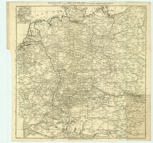
| Title | Postcurs von, Deutschland und einigen angränzenden Ländern. |
| Main title | 1 mt.: Route und Environs von Paris (Párizs környéke és útjai).. |
| Subject | Németország és a környező országok postaútjai. |
275. Post und Strassen Karte von Deutschland und dep Nachbar Staa... [B IV c 396]
Institute and Museum of Military History •
B IV c
•
B IV Német birodalom
•
B I–XV. Európa
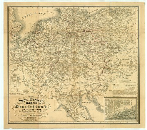
| Title | Post und Strassen Karte von Deutschland und dep Nachbar Staaten bis London Warschau und Rom. |
| Main title | Németország posta és úttérképe a környező országokkal London, Varsó és Róma vonalában. |
276. Flemmings Spezialkarte für den Deutsch–Russischen Krieg. [B IV c 397]
Institute and Museum of Military History •
B IV c
•
B IV Német birodalom
•
B I–XV. Európa
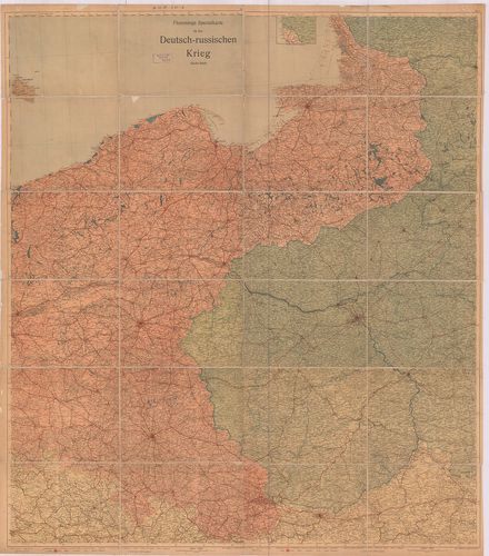
| Title | Flemmings Spezialkarte für den Deutsch–Russischen Krieg. |
| Main title | A német–orosz háború térképe. |
277. Freytags Übersichtskarte des Deutsch–Russischen Kriegsschaup... [B IV c 398]
Institute and Museum of Military History •
B IV c
•
B IV Német birodalom
•
B I–XV. Európa
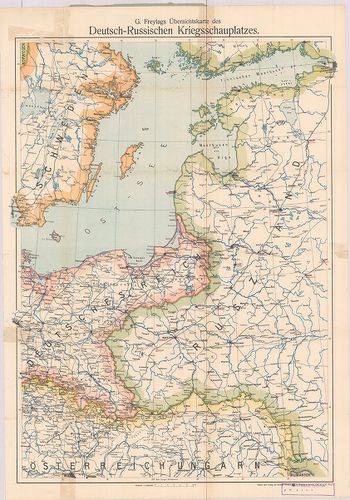
| Title | Freytags Übersichtskarte des Deutsch–Russischen Kriegsschauplatzes. |
| Main title | A német–orosz hadszíntér áttekintő térképe. |
278. Verkehrskarte Deutsche Demokratische Republik. [B IV c 399]
Institute and Museum of Military History •
B IV c
•
B IV Német birodalom
•
B I–XV. Európa
| Title | Verkehrskarte Deutsche Demokratische Republik. |
279. Német Demokratikus Köztársaság. Német Szövetségi Köztársaság... [B IV c 400]
Institute and Museum of Military History •
B IV c
•
B IV Német birodalom
•
B I–XV. Európa
| Title | Német Demokratikus Köztársaság. Német Szövetségi Köztársaság, Nyugat-Berlin autótérképe. |
280. Német Demokratikus Köztársaság, Nyugat-Berlin autótérképe. [B IV c 401]
Institute and Museum of Military History •
B IV c
•
B IV Német birodalom
•
B I–XV. Európa
| Title | Német Demokratikus Köztársaság, Nyugat-Berlin autótérképe. |
| Main title | 1 mt.: Kishatárforgalom az NDK és NSZK között. |