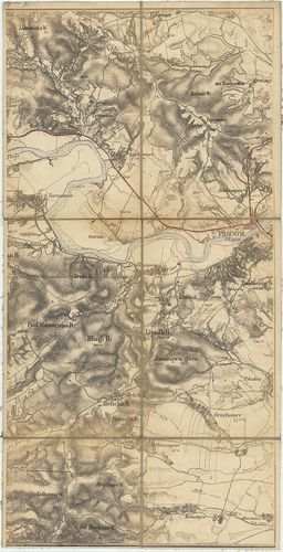
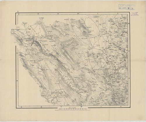
301. Az Osztrák-Magyar Monarchia III. felméréséből származó szelv... [B IX a 397]
Institute and Museum of Military History •
B IX a
•
B IX Ausztria–Magyarország
•
B I–XV. Európa
| Title | Az Osztrák-Magyar Monarchia III. felméréséből származó szelvények (104 eredeti kéziratos szelvény, a többi fekete-fehér másolatban) 1869-1885. |
302. A III. katonai felmérés alapján a két háború között készítet... [B IX a 397/1]
Institute and Museum of Military History •
B IX a
•
B IX Ausztria–Magyarország
•
B I–XV. Európa
| Title | A III. katonai felmérés alapján a két háború között készített felmérési szelvénynegyedek, (terepmunkák és gépnyomatok). 1928-1938. |
303. Mapa Komunikacyjna Galicyi i Bukowiny. [B IX a 400]
Institute and Museum of Military History •
B IX a
•
B IX Ausztria–Magyarország
•
B I–XV. Európa
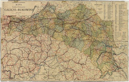
| Title | Mapa Komunikacyjna Galicyi i Bukowiny. |
| Main title | Galícia és Bukovina közlekedési térképe 1911 körül. |
304. Krakó Köz-Társaság. [B IX a 401]
Institute and Museum of Military History •
B IX a
•
B IX Ausztria–Magyarország
•
B I–XV. Európa
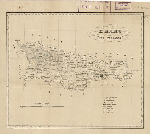
| Title | Krakó Köz-Társaság. |
305. Karte Okregu Wolnego Miasta Krakowa. – Carte du territoire d... [B IX a 402]
Institute and Museum of Military History •
B IX a
•
B IX Ausztria–Magyarország
•
B I–XV. Európa
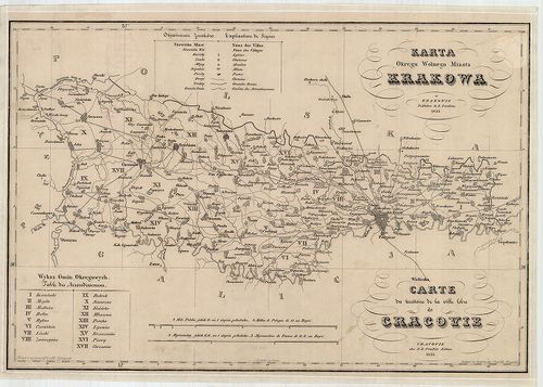
| Title | Karte Okregu Wolnego Miasta Krakowa. – Carte du territoire de la ville libre de Cracivie. |
| Main title | Krakkó szabad terület térképe 1833-ban. |
306. Karte des Krakauer Kreisesim Königreiche Galizien. – Mapa Ob... [B IX a 403]
Institute and Museum of Military History •
B IX a
•
B IX Ausztria–Magyarország
•
B I–XV. Európa
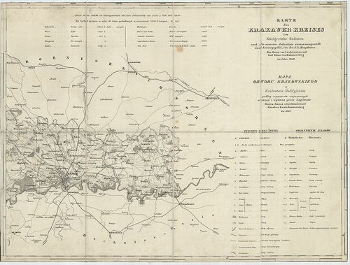
| Title | Karte des Krakauer Kreisesim Königreiche Galizien. – Mapa Obwodu Krakowskiego w Królestwie Galicyjskim… |
| Main title | A Krakkói kerület térképe 1849-ben. |
307. Karte des Krakauer Verwaltungsgebietes. [B IX a 404]
Institute and Museum of Military History •
B IX a
•
B IX Ausztria–Magyarország
•
B I–XV. Európa
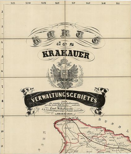
| Title | Karte des Krakauer Verwaltungsgebietes. |
| Main title | A Krakkói kerület közigazgatási térképe 1856-ban. |
308. Königreich Galicien. Kreis Przemyśl. [B IX a 405]
Institute and Museum of Military History •
B IX a
•
B IX Ausztria–Magyarország
•
B I–XV. Európa
| Title | Königreich Galicien. Kreis Przemyśl. |
| Main title | A Galíciai Királyság Przemyśli kerületének néhány szelvénye a II. katonai felmérésből: W. VI. 8., VII. 8., VIII. 7, 8. szelvények. |
309. Übersichtskarte des nördlichen Kriegsschauplatzes. [B IX a 406]
Institute and Museum of Military History •
B IX a
•
B IX Ausztria–Magyarország
•
B I–XV. Európa
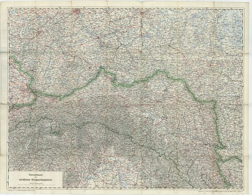
| Title | Übersichtskarte des nördlichen Kriegsschauplatzes. |
| Main title | Az orosz hadszíntér áttekintő térképe 1914-ben. (Łódž, – Warscho, Varsó, Warszava – Rowno, Rovno – Schemnitz, Selmecbánya, Banska Stiavnica – Botoşani kivágat.) |
310. Karte des Wadowicer Kreises im Königreiche Galizien… – Mapa ... [B IX a 409]
Institute and Museum of Military History •
B IX a
•
B IX Ausztria–Magyarország
•
B I–XV. Európa
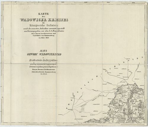
| Title | Karte des Wadowicer Kreises im Königreiche Galizien… – Mapa Obwodu Wadowiekiego w Królestwie Galicyjskim. |
| Main title | A Wadowicei kerület topográfiai térképe 1849-ben. |
311. West Galizien. I.-tes Blatt enthaltend den Krakauer, Slomnik... [B IX a 414]
Institute and Museum of Military History •
B IX a
•
B IX Ausztria–Magyarország
•
B I–XV. Európa
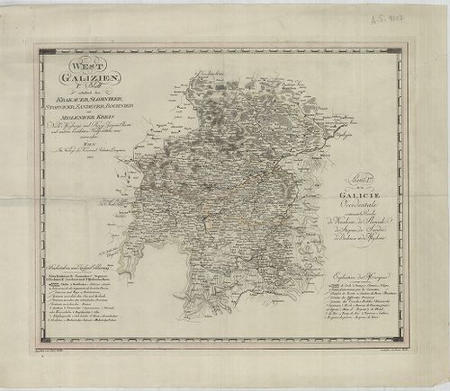
| Title | West Galizien. I.-tes Blatt enthaltend den Krakauer, Slomniker, Stopnicer, Sandecer, Bochnier und Myslenicer Kreis. – Partie I.-re de la Galicie Occidentale contenant les Cercles de Krakovie, de Slomnik de Stopnic, de Sandec, de Bochnia et de Myslenic. |
| Main title | Nyugat-Galícia térképe 1803-ban, 6 kerület megjelölésével. |
312. Ost-Galizien, Erstes Blatt enthaltend den Tarnower, Rzeszowe... [B IX a 415]
Institute and Museum of Military History •
B IX a
•
B IX Ausztria–Magyarország
•
B I–XV. Európa
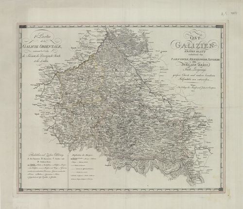
| Title | Ost-Galizien, Erstes Blatt enthaltend den Tarnower, Rzeszower, Sanoker, und Duklaer Kreis. – I. re Partie de la Galicie Orientale: Contenant les Cercles de Tarnow, de Rzeszow, de Sanok et de Dukla. |
| Main title | Kelet-Galícia térképe 1803-ban, 4 ker. megjelölésével. |
313. Ost Galizien. Zweites Blatt enthaltend den Zamoscer, Zolkiew... [B IX a 416]
Institute and Museum of Military History •
B IX a
•
B IX Ausztria–Magyarország
•
B I–XV. Európa
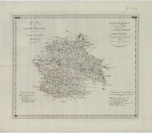
| Title | Ost Galizien. Zweites Blatt enthaltend den Zamoscer, Zolkiewer und Przemysler Kreis. – II. de Partie de la Galicie Orientale contenant les Cercles de Zamosc, de Zolkiev, et de Przemysl. |
| Main title | Kelet-Galícia térképe 1803-ban, 3 ker. megjelölésével. |
314. West Galizien. II-tes Blatt enthaltend den Konskier, Radomer... [B IX a 417]
Institute and Museum of Military History •
B IX a
•
B IX Ausztria–Magyarország
•
B I–XV. Európa
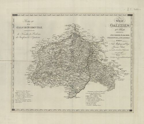
| Title | West Galizien. II-tes Blatt enthaltend den Konskier, Radomer, Jozefower und Opatower Kreis. – Partie II.-me de la Galicie Occidentale, contenant les Cercles de Konskie, de Radome, de Jozefowe et d’Opatowe. |
| Main title | Nyugat-Galícia térképe 1803-ban, 4 kerület megjelölésével. |
315. West Galizien. III.-tes Blatt enthaltend den Wiazowner, Sied... [B IX a 418]
Institute and Museum of Military History •
B IX a
•
B IX Ausztria–Magyarország
•
B I–XV. Európa
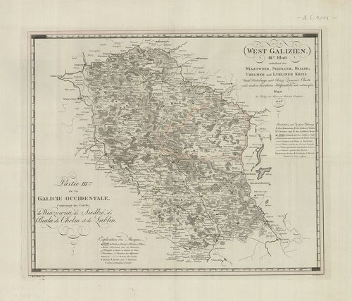
| Title | West Galizien. III.-tes Blatt enthaltend den Wiazowner, Siedlcer, Bialer, Chelmer und Lubliner Kreis. – Partie III.-me de la Galicie Occidentale, contenant les Cercles de Wiazowna, de Siedlze, de Biala, de Chelm, et de Lublin. |
| Main title | Nyugat-Galícia térképe 1803-ban, 5 kerület megjelölésével. |
316. Ost-Galizien. IV.-es Blatt enthaltend den Sanislawoner, Zale... [B IX a 419]
Institute and Museum of Military History •
B IX a
•
B IX Ausztria–Magyarország
•
B I–XV. Európa
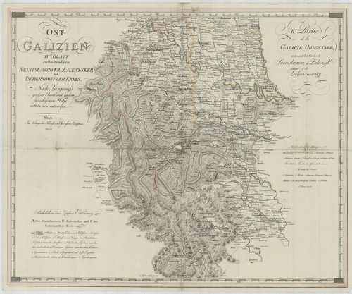
| Title | Ost-Galizien. IV.-es Blatt enthaltend den Sanislawoner, Zaleszyker und Tschernowitzer Kreis. – IV.-eme Partie de la Galicie Orientale, contenant les Cercles de Stanislawow, de Zaleszyk, et de Tschernowitz. |
| Main title | Kelet-Galícia térképe 1803-ban, 3 kerület megjelölésével. |
317. Galícia és Bukovina. [B IX a 420]
Institute and Museum of Military History •
B IX a
•
B IX Ausztria–Magyarország
•
B I–XV. Európa
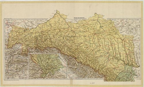
| Title | Galícia és Bukovina. |
318. Galícia és Bukovina. [B IX a 421]
Institute and Museum of Military History •
B IX a
•
B IX Ausztria–Magyarország
•
B I–XV. Európa
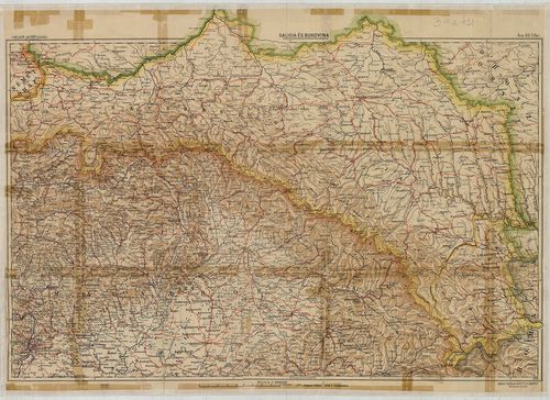
| Title | Galícia és Bukovina. |
319. Galizien und Nordost–Ungarn. [B IX a 422]
Institute and Museum of Military History •
B IX a
•
B IX Ausztria–Magyarország
•
B I–XV. Európa
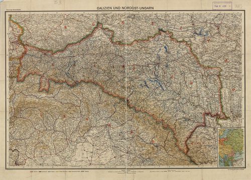
| Title | Galizien und Nordost–Ungarn. |
| Main title | Mt. Übersichtskarte von Osteuropa. (K-Európa áttekintő térk.) |
| Subject | Galícia és Magyarország ÉK-i részének térképe 1910 körül. |
320. G. Freytags Karte der Bukowina. [B IX a 423]
Institute and Museum of Military History •
B IX a
•
B IX Ausztria–Magyarország
•
B I–XV. Európa
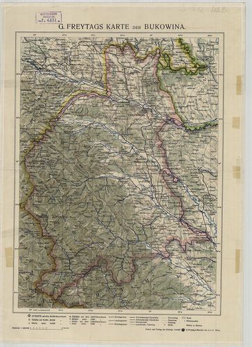
| Title | G. Freytags Karte der Bukowina. |
| Main title | Bukovina térképe 1910 körül. |
321. Handkarte des Herzogthumes Bukowina. [B IX a 424]
Institute and Museum of Military History •
B IX a
•
B IX Ausztria–Magyarország
•
B I–XV. Európa
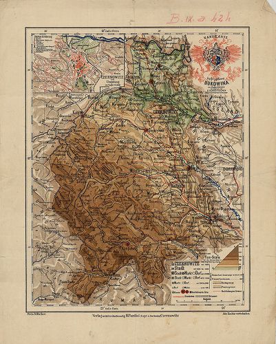
| Title | Handkarte des Herzogthumes Bukowina. |
| Main title | Mt. Czernowitz und Umgebung. (Csernovitz, Csernovci és körny.) |
| Subject | A Bukovina Hercegség, térképe 1890 körül. |
322. [Galícia és Bukovina topográfiai térképe a 19. században.] [B IX a 425]
Institute and Museum of Military History •
B IX a
•
B IX Ausztria–Magyarország
•
B I–XV. Európa
| Title | [Galícia és Bukovina topográfiai térképe a 19. században.] |
323. Carte Bucowiner District. [B IX a 426]
Institute and Museum of Military History •
B IX a
•
B IX Ausztria–Magyarország
•
B I–XV. Európa
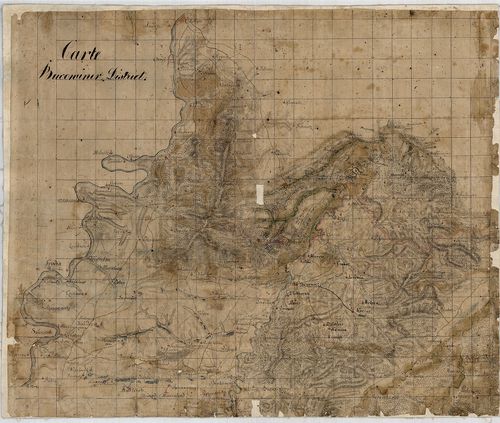
| Title | Carte Bucowiner District. |
| Main title | Bukovina térképe a 18. században. |
324. Verkehrskarte des Herzogtumes Bukowina. [B IX a 429]
Institute and Museum of Military History •
B IX a
•
B IX Ausztria–Magyarország
•
B I–XV. Európa
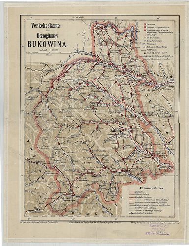
| Title | Verkehrskarte des Herzogtumes Bukowina. |
| Main title | A Bukovina Hercegség közlekedési térképe 1907-ben. |
325. Carta dell’Istria Riveduta et aumentata dol Ceasaero Reggio. [B IX a 440]
Institute and Museum of Military History •
B IX a
•
B IX Ausztria–Magyarország
•
B I–XV. Európa
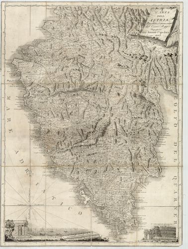
| Title | Carta dell’Istria Riveduta et aumentata dol Ceasaero Reggio. |
| Main title | Az Isztriai-félsziget térképe 1803-ban. |
326. I. Charte des Nordwestlichen Theiles von Dalmatien. – Partie... [B IX a 441]
Institute and Museum of Military History •
B IX a
•
B IX Ausztria–Magyarország
•
B I–XV. Európa
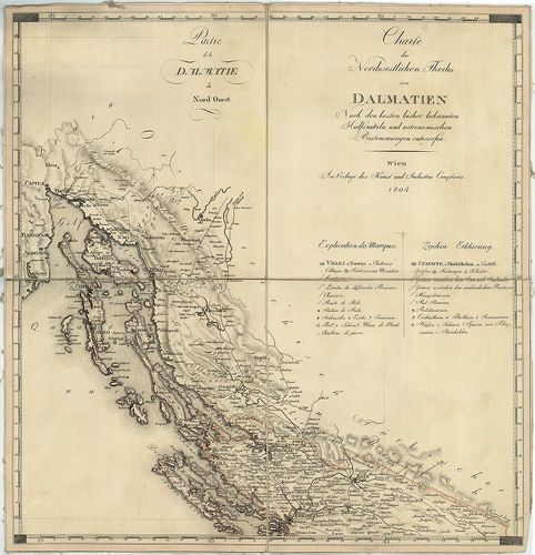
| Title | I. Charte des Nordwestlichen Theiles von Dalmatien. – Partie de la Dalmatie du Nord Quest. II. Charte des Südöstlichen Theiles von Dalmatien mit dem Oesterreichischen Antheile von Albanien. – Partie de la Dalmatie du Sud Est avec l’Albanie. |
| Main title | ÉNY- és DK-Dalmácia térképe Albánia osztrák fennhatóság alatt álló részével 1804-ben. |
327. Carta Novissima della Dalmazia, Albania, Croazia, Bosnia [B IX a 442]
Institute and Museum of Military History •
B IX a
•
B IX Ausztria–Magyarország
•
B I–XV. Európa
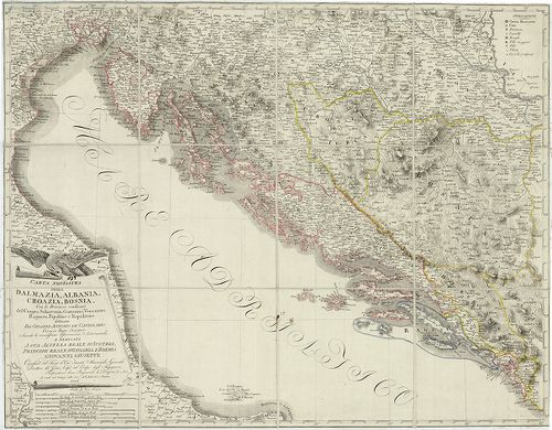
| Title | Carta Novissima della Dalmazia, Albania, Croazia, Bosnia |
| Main title | Dalmácia, Albánia, Horvátország, Bosznia "új" térképe 1806-ban, határjelöléssel. |
328. Carte des Provinces Illyriennes Comprenant La Bosnie, L’Herz... [B IX a 443]
Institute and Museum of Military History •
B IX a
•
B IX Ausztria–Magyarország
•
B I–XV. Európa
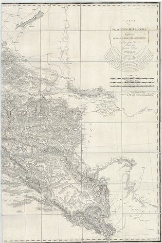
| Title | Carte des Provinces Illyriennes Comprenant La Bosnie, L’Herzegovine, Le Monténero… |
| Main title | Illiria, Bosznia–Hercegovina, Montenegro térképe 1812-ben. |
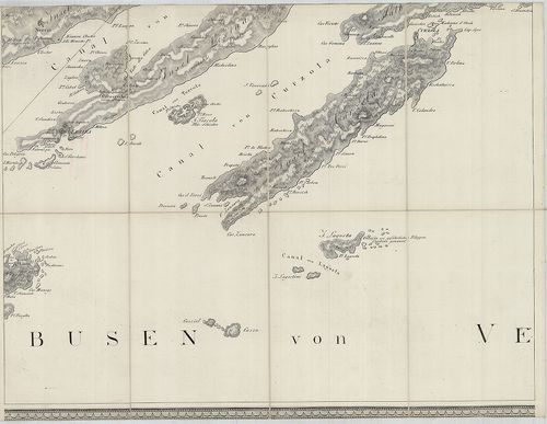
329. 1. Nouvelle Carte de la Partie Occidentale de Dalmatie. – II... [B IX a 446]
Institute and Museum of Military History •
B IX a
•
B IX Ausztria–Magyarország
•
B I–XV. Európa
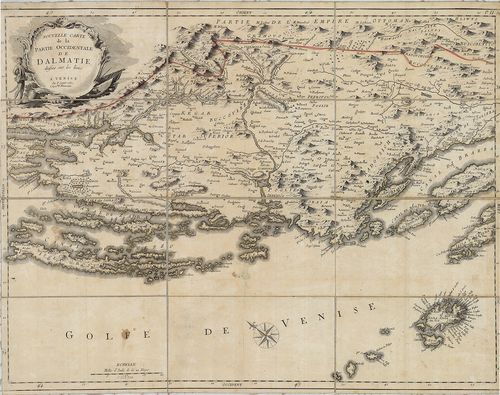
| Title | 1. Nouvelle Carte de la Partie Occidentale de Dalmatie. – II. Nouvelle Carte de la Orientale de Dalmatie. |
| Main title | Mt. Baye ou Bocche di Cattaro. (Kotori-ö.) |
| Subject | Dalmácia NY-i és K-i részének "új" térképe 1780-ban. |
330. Carta prospettiva delle Comuni Censuarie della Dalmazia. [B IX a 450]
Institute and Museum of Military History •
B IX a
•
B IX Ausztria–Magyarország
•
B I–XV. Európa
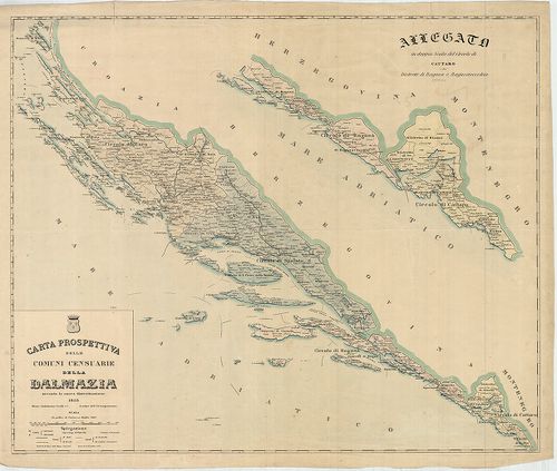
| Title | Carta prospettiva delle Comuni Censuarie della Dalmazia. |
| Main title | Mt. Allegato in doppia Scala del Circolo di Cattaro e dei Distretti di Raguza e Ragusavecchia. (Kataro, Kotor, – Ragusa, Dubrovnik, – Ragusavecchia, Ragusa-Óváros, Cavtat, ker.). |
| Subject | Dalmácia közigazgatási térképe 1853-ban, kerületi beosztással. |
331. G. Freytags Karte der Oesterreichisch–Ungarischen Küstenländ... [B IX a 451]
Institute and Museum of Military History •
B IX a
•
B IX Ausztria–Magyarország
•
B I–XV. Európa
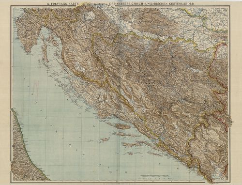
| Title | G. Freytags Karte der Oesterreichisch–Ungarischen Küstenländer. |
| Main title | Az Osztrák-Magyar Monarchia Tengermellék tartományának térképe 1915 körül. |
332. Carte von Dalmatien und dem Gebieth von Ragusa. [B IX a 455]
Institute and Museum of Military History •
B IX a
•
B IX Ausztria–Magyarország
•
B I–XV. Európa
| Title | Carte von Dalmatien und dem Gebieth von Ragusa. |
| Main title | Dalmácia és Raguza (Dubrovnik) térképe 1829-ben. |
333. Special-Karte des Koenigreiches Dalmatien. [B IX a 458]
Institute and Museum of Military History •
B IX a
•
B IX Ausztria–Magyarország
•
B I–XV. Európa
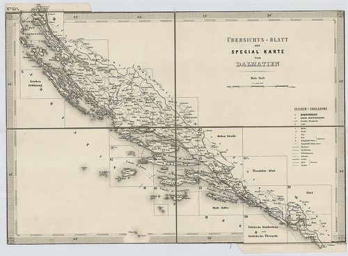
| Title | Special-Karte des Koenigreiches Dalmatien. |
| Main title | Dalmácia részletes térképe 1863-ban, a II. katonai felmérés alapján. |
334. Special-Karte des Koenigreiches Dalmatien. [B IX a 458]
Institute and Museum of Military History •
B IX a
•
B IX Ausztria–Magyarország
•
B I–XV. Európa
| Title | Special-Karte des Koenigreiches Dalmatien. |
335. Carte von dem venetianischen Antheil in Albanien Bocche die ... [B IX a 464]
Institute and Museum of Military History •
B IX a
•
B IX Ausztria–Magyarország
•
B I–XV. Európa
| Title | Carte von dem venetianischen Antheil in Albanien Bocche die Cattaro genannt. |
| Main title | A Cattaroi-öböl (Kotori-öböl) környéke 1720-ban. |
336. Carte des Bouches de Cattaro et du Montenegro. [B IX a 471]
Institute and Museum of Military History •
B IX a
•
B IX Ausztria–Magyarország
•
B I–XV. Európa
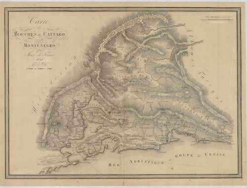
| Title | Carte des Bouches de Cattaro et du Montenegro. |
| Main title | A Cattaroi-öböl (Kotori-öböl) és Montenegró térképe 1830-ban. |
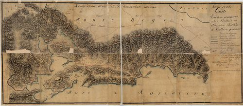
337. Süd-Dalmatien mit den angrenzenden Theilen der Herzegovina u... [B IX a 475]
Institute and Museum of Military History •
B IX a
•
B IX Ausztria–Magyarország
•
B I–XV. Európa
| Title | Süd-Dalmatien mit den angrenzenden Theilen der Herzegovina und Montenegro’s. |
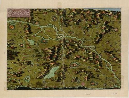
| Main title | Dalmácia D-i részének és a csatlakozó hercegovinai és montenegrói területek topográfiai térképe 1870 körül, Dalmácia 1:144 000 méretarányú részletes térképének felnagyításával. |
338. Karte von dem Königreiche Ungarn mit den Königreichen Kroati... [B IX a 480]
Institute and Museum of Military History •
B IX a
•
B IX Ausztria–Magyarország
•
B I–XV. Európa
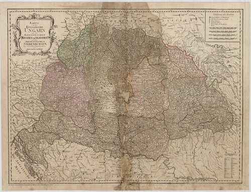
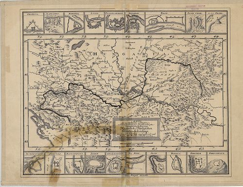
| Title | Karte von dem Königreiche Ungarn mit den Königreichen Kroatien und Sklavonien und dem Grossfürstenthum Siebenbürgen. |
| Main title | A Magyar Királyság, a Horvát-Szlavón Királyság és az Erdélyi Nagyfejedelemség térképe 1796-ban. |
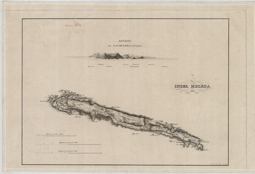
339. Insel Meleda. [B IX a 481]
Institute and Museum of Military History •
B IX a
•
B IX Ausztria–Magyarország
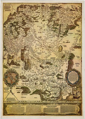
•
B I–XV. Európa
| Title | Insel Meleda. |
| Main title | Mt. Ansicht der Insel Meleda von Nordost. (Meleda, Mljet sziget látképe ÉK-ről) |
| Subject | Meleda-sziget térképe 1825-ben. |
340. A Descript. of Hungary. [B IX a 482/1]
Institute and Museum of Military History •
B IX a
•
B IX Ausztria–Magyarország
•
B I–XV. Európa
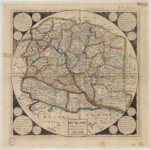
| Title | A Descript. of Hungary. |
| Main title | Magyarország térképe 1700 körül. |
341. La Hongrie avec les Provinces adjacentes: formant tout ensem... [B IX a 482/2]
Institute and Museum of Military History •
B IX a
•
B IX Ausztria–Magyarország
•
B I–XV. Európa
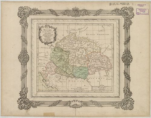
| Title | La Hongrie avec les Provinces adjacentes: formant tout ensemble 2. Grandes Provinces Eclésiastiques. |
| Main title | Magyarország és a szomszédos országok térképe 1766-ban, hivatkozással az esztergomi és a kalocsai püspökségre.. |
342. Hungariae ampliori significatu et veteris vel Methodicae, co... [B IX a 482/3]
Institute and Museum of Military History •
B IX a
•
B IX Ausztria–Magyarország
•
B I–XV. Európa
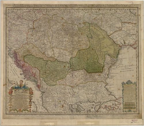
| Title | Hungariae ampliori significatu et veteris vel Methodicae, complexae Regna Hungariae, Propriae, Croatiae, Dalmatiae, Bosniae, Serviae, Bulgariae, Cumaniae, Principatum Transylvaniae… |
| Main title | Magyarország (Magyar Királyság, Horvát-Szlavónia, Dalmácia, Bosznia, Szerbia, Bulgária, Erdély stb.) térképe 1744-ben. |
343. Vetustissimi Potentissimique Hungariae Regni Transsylvaniaeq... [B IX a 482/5]
Institute and Museum of Military History •
B IX a
•
B IX Ausztria–Magyarország
•
B I–XV. Európa
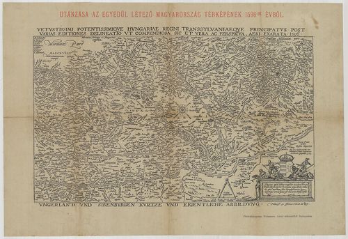
| Title | Vetustissimi Potentissimique Hungariae Regni Transsylvaniaeque Principatus Post Varias Editiones Denineatio ut Compendiasa sic et vera ac Perspicua, aeri exarata 1596. – Utánzása az egyedül létező Magyarország térképének 1596-ik évből. |
344. Tabula Hungarie ad quatour latera per Lazarum quondam Thomae... [B IX a 482/6]
Institute and Museum of Military History •
B IX a
•
B IX Ausztria–Magyarország
•
B I–XV. Európa
| Title | Tabula Hungarie ad quatour latera per Lazarum quondam Thomae Strigonien Cardin. Secretariu viru, exptuz congesta, á Georgio Tanstetter Collimitio reuisa auctiorqz reddita atque iamprimu á Io. Cuspiniano edita Serenissimo Hungarie et Bohemiae Regi Ferdinando principi et infanti. Hispaniarum Archiduci Austriae ec. Sacra, auspitio maiestatis suae ob reip Christiane vsum, opera Petri Apiani de Leyssnigk Mathematici Ingolstadiani inuulgata Anno Dni 1528. |
| Main title | Lázár Magyarország térképének (1528) fakszimile kiadása 1972-ben. |
345. Warhafftige Situation aller Städt u. Vestungen, So’ von der ... [B IX a 482/7]
Institute and Museum of Military History •
B IX a
•
B IX Ausztria–Magyarország
•
B I–XV. Európa
| Title | Warhafftige Situation aller Städt u. Vestungen, So’ von der Käyserl. Residenz Stadt Wien bis an die Essecke Brücken, so wol an der Donau als ander Flüssen, theils noch in der Türcken Gewalt sich befinden, theils aber von den Christen eine zeithero erobert worden. |
| Main title | Magyarország Ny-i részének térképe a 17. században. Bécs és az eszéki híd között elterülő várak és városok részben alaprajzos, részben oldalnézetes ábrázolása. A császári kézben levő helységeket kereszt, a török kézben levőket félhold jelöli. |
346. Tabula Hungarie ad quatuor latera per Lazarum quondam Thomae... [B IX a 482/8]
Institute and Museum of Military History •
B IX a
•
B IX Ausztria–Magyarország
•
B I–XV. Európa
| Title | Tabula Hungarie ad quatuor latera per Lazarum quondam Thomae Strigonien, Cardin. Secretariu viru exptuz congesta á Georgio Tanstetter Collimitio reuisa auctiorqz reddita, atque iamprimu á Io. Cuspiniano edita Serenissimo Hungarie et Bohemiae Regi Ferdinando principi et infanti. Hispaniarum Archiduci Austriae ec. Sacra auspitio maiestatis suae. ob Leyssnigk Mathematici Ingolstadi ani inuulgata Anno Dni 1528. véste: Collimitius Tanstetter György. |
| Main title | Lázár Magyarország térképének (1528) fakszimile kiadása 1972-ben. |
347. Mappa der zu Carlovitz geschlossenen und hernach durch zwey ... [B IX a 482/10]
Institute and Museum of Military History •
B IX a
•
B IX Ausztria–Magyarország
•
B I–XV. Európa
| Title | Mappa der zu Carlovitz geschlossenen und hernach durch zwey gevollmäehtigte Commissarios vollzogenen Kaiserlich-Türkischen Gräntz-Scheidung… |
| Main title | Magyarország déli határa a karlócai béke szerint 1699-ben. |
348. Nova Descriptio Totius Hungariae. [B IX a 482/11]
Institute and Museum of Military History •
B IX a
•
B IX Ausztria–Magyarország
•
B I–XV. Európa
| Title | Nova Descriptio Totius Hungariae. |
| Main title | Lázár Magyarország térképének 1558-as római kiadásának fakszimiléje 1972-ben. |
349. Nova Descriptio Totius Hungariae. [B IX a 482/12]
Institute and Museum of Military History •
B IX a
•
B IX Ausztria–Magyarország
•
B I–XV. Európa
| Title | Nova Descriptio Totius Hungariae. |
| Main title | Lázár Magyarország térképének 1559-es római kiadásának fakszimiléje 1972-ben. |
350. Ungariae Tanst. Descriptio nunc correcta, et aucta Maximil I... [B IX a 482/13]
Institute and Museum of Military History •
B IX a
•
B IX Ausztria–Magyarország
•
B I–XV. Európa
| Title | Ungariae Tanst. Descriptio nunc correcta, et aucta Maximil II. Aug. Opt. PR. PP. Dicata Per I. Samb. MDL XVI. Faciebat DH. |
| Main title | Magyarország térképének 1566-os bécsi kiadásának fakszimiléje 1972-ben. |