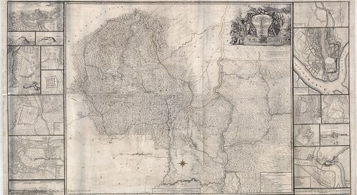
351. Nova Descriptio Totius Ungariae. – Tabula Hungariae ad quatu... [B IX a 482/14]
Institute and Museum of Military History •
B IX a
•
B IX Ausztria–Magyarország
•
B I–XV. Európa
| Title | Nova Descriptio Totius Ungariae. – Tabula Hungariae ad quatuor Latera per Lazarum… a Georgio Tanster ex Collimitio… opa Petri Apiani de Leyssigk… Anno 1553. |
| Main title | Lázár Magyarország térképének 1553-as velencei kiadásának fakszimiléje 1972-ben. |
352. [A királyi Magyarország térképe a 17. században.]. [B IX a 483/1]
Institute and Museum of Military History •
B IX a
•
B IX Ausztria–Magyarország
•
B I–XV. Európa
| Title | [A királyi Magyarország térképe a 17. században.]. |
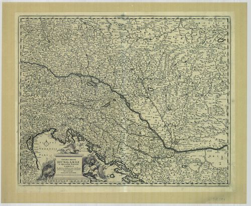
353. Praecipiorum Superioris ac Inferioris Hungariae Munitiorum t... [B IX a 483/2]
Institute and Museum of Military History •
B IX a
•
B IX Ausztria–Magyarország
•
B I–XV. Európa
| Title | Praecipiorum Superioris ac Inferioris Hungariae Munitiorum tum suae Maiestatis Caesariae, tum Turcarum Subiectorum Descriptio… |
| Main title | A királyi Magyarország térképe 1653-ban. |
354. Montanae Civitates. [B IX a 483/3]
Institute and Museum of Military History •
B IX a
•
B IX Ausztria–Magyarország
•
B I–XV. Európa
| Title | Montanae Civitates. |
| Main title | Magyarország ÉNy-i részének - a Felvidék térképe a 17. században. (A Duna–Vág–Rimaszombat, Rimavská Sobota–Zólyom, Zvolen között.) |
355. Superior Ungaria. [B IX a 483/4]
Institute and Museum of Military History •
B IX a
•
B IX Ausztria–Magyarország
•
B I–XV. Európa
| Title | Superior Ungaria. |
| Main title | Felső-Magyarország térképe a 17. században. Szolnoktól a határokig. (Lőcse, Levoča–Vác–Visk, Viskovo között.) |
356. Ditio inter Mura et Danubium. [B IX a 483/5]
Institute and Museum of Military History •
B IX a
•
B IX Ausztria–Magyarország
•
B I–XV. Európa
| Title | Ditio inter Mura et Danubium. |
| Main title | A Dunántúl általános térképe a 17. században. (Győr–Fehérvár–Sághegy–Kanizsa között.) |
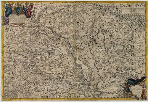
357. Nova et accurata totius Hungariae descriptio, cum adiacentib... [B IX a 483/6]
Institute and Museum of Military History •
B IX a
•
B IX Ausztria–Magyarország
•
B I–XV. Európa
| Title | Nova et accurata totius Hungariae descriptio, cum adiacentibus Regionibus videlicet Transylvania Sclavonia et Croatia. |
| Main title | Magyarország, Erdély, Szlavónia és Horvátország térképe 1664-ben. |
358. Carta topographica ciuitatis fortalityque Varadini (Oradea) ... [B IX a 483/9]
Institute and Museum of Military History •
B IX a
•
B IX Ausztria–Magyarország
•
B I–XV. Európa
| Title | Carta topographica ciuitatis fortalityque Varadini (Oradea) magni eorumque circumiacentium. |
| Main title | Bihar megye (Erdély) nagy részének térképe a 17. században. |
359. a) Tiszántúl D-i részének térképe. (Debrecen–Szeged–Temesvár... [B IX a 483/10]
Institute and Museum of Military History •
B IX a
•
B IX Ausztria–Magyarország
•
B I–XV. Európa
| Title | a) Tiszántúl D-i részének térképe. (Debrecen–Szeged–Temesvár, Timisoara, között. |
| Main title | b) Nagyvárad környéke. |
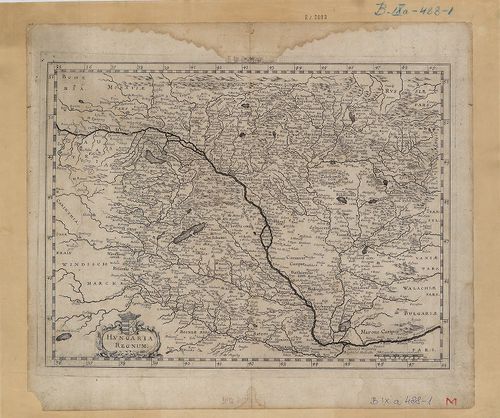
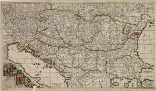
360. Hungaria Regnum. [B IX a 484]
Institute and Museum of Military History •
B IX a
•
B IX Ausztria–Magyarország
•
B I–XV. Európa
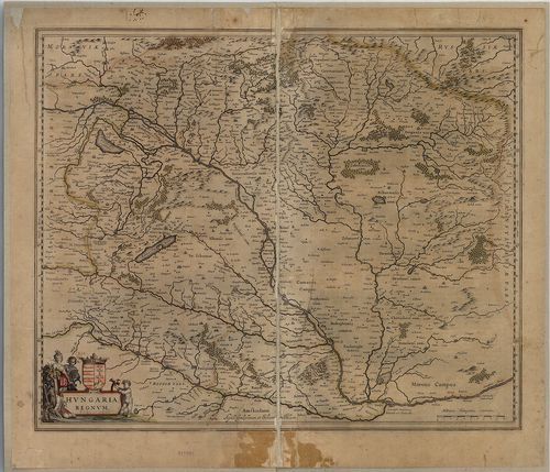
| Title | Hungaria Regnum. |
| Main title | Magyarország térképe 1640 körül. |
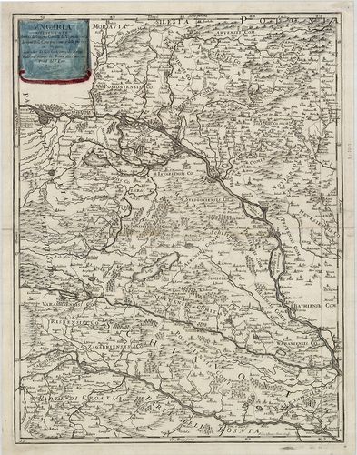
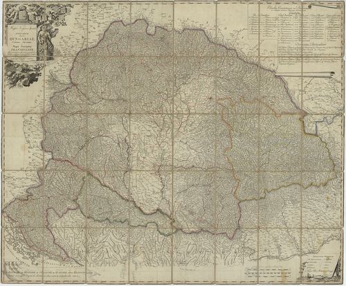
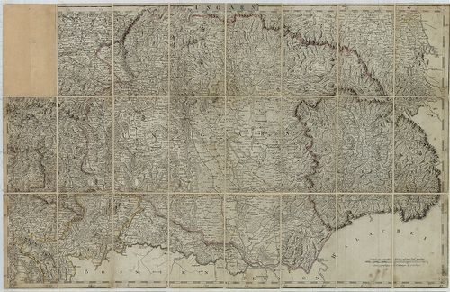
361. Totius Regni Hungariae et adjacentium Regionum Tabula / A[nn... [B IX a 485]
Institute and Museum of Military History •
B IX a
•
B IX Ausztria–Magyarország
•
B I–XV. Európa
| Title | Totius Regni Hungariae et adjacentium Regionum Tabula / A[nno] 1687 ob res bellicas inter Christianos et Turcas exacte correcta ac innumeris locis aucta per… |
| Main title | A Magyar Királyság és a szomszédos területek térképe 1687 körül. |
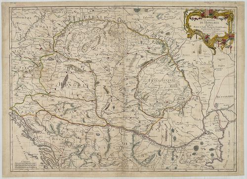
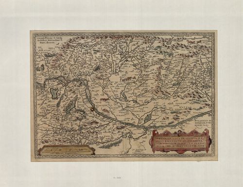
362. Transylvania / Sibenburgen. [B IX a 486]
Institute and Museum of Military History •
B IX a
•
B IX Ausztria–Magyarország
•
B I–XV. Európa
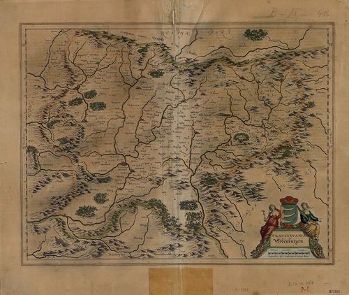
| Title | Transylvania / Sibenburgen. |
| Main title | Erdély térképe Mercator nyomán 1635 körül. |
363. Austria Archiducatus. [B IX a 487]
Institute and Museum of Military History •
B IX a
•
B IX Ausztria–Magyarország
•
B I–XV. Európa

| Title | Austria Archiducatus. |
| Main title | Ausztria térképe Lazius 16. századi térképe alapján. |
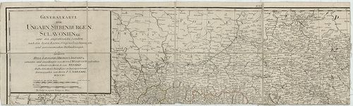
364. Vermehrte und verbesserte Landkarten des Königreichs Ungarn ... [B IX a 487/1]
Institute and Museum of Military History •
B IX a
•
B IX Ausztria–Magyarország
•
B I–XV. Európa
| Title | Vermehrte und verbesserte Landkarten des Königreichs Ungarn und deren andern angrentzenden Königreiche Fürstenthumen und Landschafften samt denen Grentz, Posten, … Ertzhaus Oesterreich von dem Adriatischen Meer an bis in Siebenbürgen vor Verstungen und Plätze gegen dem Erbfeind zu Nutz der gantzen Christenheit… |
| Main title | A Magyar Királyság,, Ausztria, Horvátország és Erdély, térképe 1684-ben. |
365. Hungariae Descriptio. Wolfgango Lazio auct. [B IX a 487/1-1]
Institute and Museum of Military History •
B IX a
•
B IX Ausztria–Magyarország
•
B I–XV. Európa
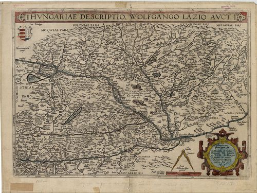
| Title | Hungariae Descriptio. Wolfgango Lazio auct. |
| Main title | Magyarország térképe 1575 körül. |
366. Mappa della, Transilvania, e Provintie contique nella quales... [B IX a 487/15]
Institute and Museum of Military History •
B IX a
•
B IX Ausztria–Magyarország
•
B I–XV. Európa
| Title | Mappa della, Transilvania, e Provintie contique nella qualesivedano li Consini dell’ Ongaria eli Campam fatti dall; Arpate Cesaree in quelte ultime guere. |
| Main title | A térk. Ny-i és K-i szélén 16 város, ill. vár alapr. és látképe. 1. Veduta d’Oriente de Schesburg. [Segesvár, Sighişoara látképe K-ről.] 2. Veduta da mezzo giorno di Deva. [Déva, Deva) látképe dél felöl.] 3. Veduta da Ponente di G˙rg˙n˙. [Görgény vár látképe Ny-ról.] 4. Pianta di Kronstadt. [Brassó-i vár, Braşow) alapr.] 5. Pianta di Udvarhell. [Székelyudvarhely, Odorheiu, alapr.] 6. Pianta di Fogaras. [Făgăras, vár alapr.] 7. Pianta di Klausemburg. [Kolozsvár, Cluj, alapr.] 8. Hermannstadt Citta Capitale della Transilvania. [Nagyszeben, Sibiu, Erdély fővárosa, alapr.] 9. Veduta da ponente della Citta di Hermannstadt. [Nagyszeben, Sibiu,) látképe Ny-ról.] 10. Disegno di Nissa. [Niš vár) alapr.] 11. Pianta di Belgrado. [Beograd, alapr.] 12. Pianta di Bistrizza. [Besztercei vár, Bistriţa alapr.] 13. Pianta di Medies. [Medgyesi vár, Medias alapr.] 14. Pianta di Samoshuyvar. [Szamosújvár, Gherla alapr.] 15. Veduta damezo giorno Samoshuyvar. [Szamosujvár, Gherla) látképe.] 16. Peter Varadino… [Pétervárad, Petrovaradin alapr.] |
| Subject | Erdély és a vele határos tartományok térképe 1699-ben. |
367. Tabula Nova Inclyti Regni Hungariae juxta nonnullas Observat... [B IX a 487/29]
Institute and Museum of Military History •
B IX a
•
B IX Ausztria–Magyarország
•
B I–XV. Európa
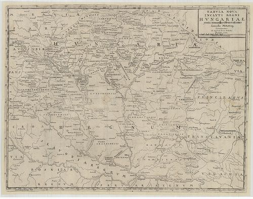
| Title | Tabula Nova Inclyti Regni Hungariae juxta nonnullas Observationes. |
| Main title | Magyarország térképe 1753-ban. |
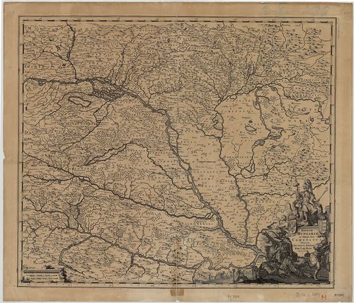
368. Hungaria Regnum. [B IX a 488/1]
Institute and Museum of Military History •
B IX a
•
B IX Ausztria–Magyarország
•
B I–XV. Európa
| Title | Hungaria Regnum. |
| Main title | Magyarország térképe a 17. században. |
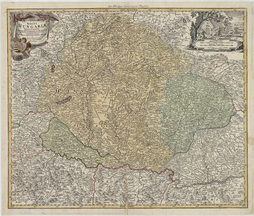
369. Regnum Hungariae in Omnes suos Comitatus Accurate Divisum… [B IX a 489]
Institute and Museum of Military History •
B IX a
•
B IX Ausztria–Magyarország
•
B I–XV. Európa
| Title | Regnum Hungariae in Omnes suos Comitatus Accurate Divisum… |
| Main title | A Magyar Királyság általános térképe a XVII. század végén. |
370. [A Duna–Tisza–Maros közének térképe.] [B IX a 489/1]
Institute and Museum of Military History •
B IX a
•
B IX Ausztria–Magyarország
•
B I–XV. Európa
| Title | [A Duna–Tisza–Maros közének térképe.] |
371. Regni Hungariae et Regionum, quae ei quondam fuere unitae, u... [B IX a 490]
Institute and Museum of Military History •
B IX a
•
B IX Ausztria–Magyarország
•
B I–XV. Európa
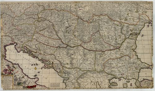
| Title | Regni Hungariae et Regionum, quae ei quondam fuere unitae, ut Transilvaniae, Valachiae, Moldaviae, Serviae, Romaniae, Bulgariae, Bessarábiae, Croatiae, Bosniae, Dalmatiae, Sclavoniae, Morlachiae, Ragusanae Republicae Maximaequ Partis Danubii Fluminis. |
| Main title | A Magyar Királyság és a környező államok (Duna menti országok) térképe 1688-ban. |
372. Le Royaume de Hongrie Diuisé en Haute et Basse Hongrie auec ... [B IX a 490/1]
Institute and Museum of Military History •
B IX a
•
B IX Ausztria–Magyarország
•
B I–XV. Európa
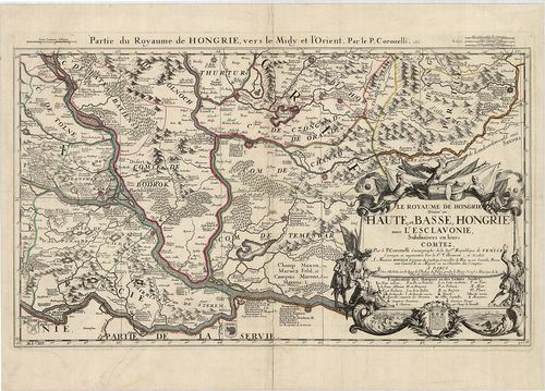
| Title | Le Royaume de Hongrie Diuisé en Haute et Basse Hongrie auec l’Esclavonie, Subdiuisees en leurs Comitez. Partie du Royaume de Hongrie, vers le Midy et l’Orient. |
| Main title | A Magyar Királyság D-i részének térképe 1688-ban, megyebeosztással és megnevezéssel. |
373. Le Royaume de Hongrie divisé en Haute et Basse Hongrie, Tran... [B IX a 490/2]
Institute and Museum of Military History •
B IX a
•
B IX Ausztria–Magyarország
•
B I–XV. Európa
| Title | Le Royaume de Hongrie divisé en Haute et Basse Hongrie, Transilvanie, Esclavonie et Croatie. |
| Main title | A Magyar Királyság, Erdély és Horvát-Szlavónia térképe 1759-ben. |
374. Il Regno d’Ungaria, Transilvania, Schiavonia, Bosnia, Croati... [B IX a 490/3]
Institute and Museum of Military History •
B IX a
•
B IX Ausztria–Magyarország
•
B I–XV. Európa
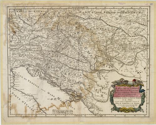
| Title | Il Regno d’Ungaria, Transilvania, Schiavonia, Bosnia, Croatia, Dalmatia… |
| Main title | A Magyar Királyság, Erdély, Szlavónia, Bosznia, Horvátország és Dalmácia térképe 1683-ban. |
375. Ungaria Occidentale. [B IX a 490/4]
Institute and Museum of Military History •
B IX a
•
B IX Ausztria–Magyarország
•
B I–XV. Európa
| Title | Ungaria Occidentale. |
| Main title | Magyarország nyugati részének térképe 1683-ban. |
376. Ungariae loca praecipua recens emendata atque edita… [B IX a 490/5]
Institute and Museum of Military History •
B IX a
•
B IX Ausztria–Magyarország
•
B I–XV. Európa
| Title | Ungariae loca praecipua recens emendata atque edita… |
| Main title | Magyarország térképe 1579-ben. |
377. Landtafel des Ungerlands, Polands, Reussen, Littaw, Wallache... [B IX a 490/6]
Institute and Museum of Military History •
B IX a
•
B IX Ausztria–Magyarország
•
B I–XV. Európa
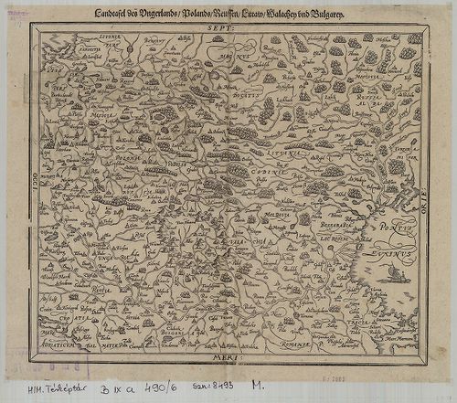
| Title | Landtafel des Ungerlands, Polands, Reussen, Littaw, Wallachey und Bulgarey. |
| Main title | Magyarország, Lengyelország, Oroszország, Litvánia, Havasalföld, Bulgária térképe a 16. században. |
378. Regni Hungariae, et Regionum, quae ei quondem fuere unitae. ... [B IX a 490/7]
Institute and Museum of Military History •
B IX a
•
B IX Ausztria–Magyarország
•
B I–XV. Európa
| Title | Regni Hungariae, et Regionum, quae ei quondem fuere unitae. ut Transilvaniae, Valachiae, Moldaviae, Serviae, Romaniae, Bulgariae, Bessarabiae, Croatiae, Bosniae, Dalmatiae, Sclavoniae, Morlachiae, Ragusanae, Republicae… |
| Main title | A Magyar Királyság és a Balkán-félsziget térképe 1688-ban. |
379. Augustissimo Romanor Imperatori Iosepho I. Hungariae Regni i... [B IX a 491]
Institute and Museum of Military History •
B IX a
•
B IX Ausztria–Magyarország
•
B I–XV. Európa
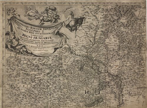
| Title | Augustissimo Romanor Imperatori Iosepho I. Hungariae Regni invictissimo Mappam Hanc Regni Hungariae propitiis elementis fertilissimi cum adjacentibus regnis et Provinciis nova et accuratiori forma ex optimis schedis collectam D. D. D. … |
| Main title | A Magyar Királyság, Horvátország, Szlavónia, Erdély, Ausztria, Karintia, Stájerország térképe 1709-ben. |
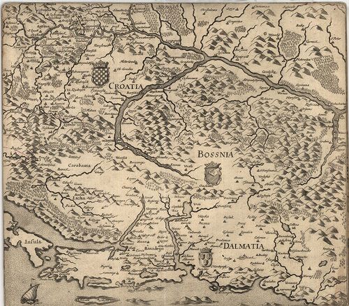
380. Regnorum Hungariae Dalmatiae, Croatiae, Sclavoniae, Bosniae,... [B IX a 493]
Institute and Museum of Military History •
B IX a
•
B IX Ausztria–Magyarország
•
B I–XV. Európa
| Title | Regnorum Hungariae Dalmatiae, Croatiae, Sclavoniae, Bosniae, et Serviae cum Principatu Transylvaniae, maximaque Partte Walachiae nova et exacta tabula… |
| Main title | A Magyar Királyság, Dalmácia, Horvát-Szlavónia, Bosznia, Szerbia, Erdély térképe 1720 körül. |
381. Regni Hungariae Tabula Generalis. [B IX a 493/2]
Institute and Museum of Military History •
B IX a
•
B IX Ausztria–Magyarország
•
B I–XV. Európa
| Title | Regni Hungariae Tabula Generalis. |
| Main title | A Magyar Királyság 1718 -ban. |
382. L’Impero d’Austria. [B IX a 494]
Institute and Museum of Military History •
B IX a
•
B IX Ausztria–Magyarország
•
B I–XV. Európa
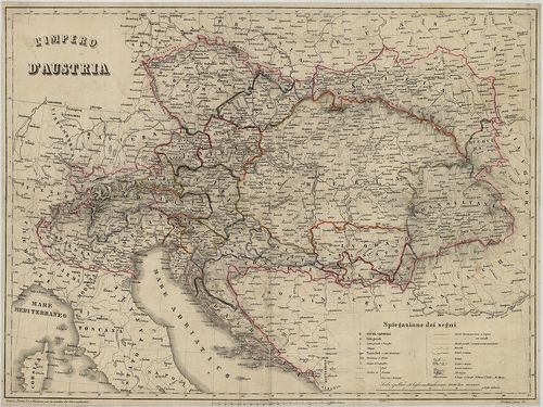
| Title | L’Impero d’Austria. |
| Main title | Az Osztrák Birodalom térképe 1855 körül. A tartományok jelölése és megnevezése. |
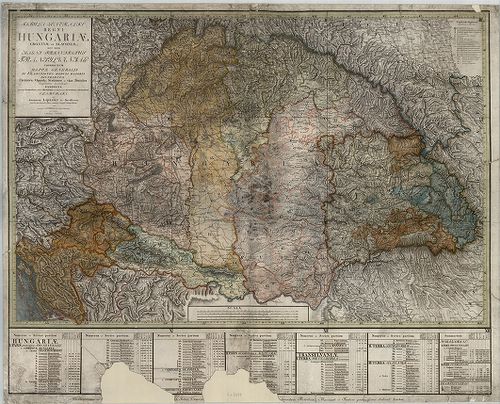
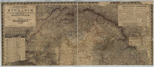
383. Generalkarte von Ungarn, Siebenbürgen, Sclavonien etc. Samt ... [B IX a 495]
Institute and Museum of Military History •
B IX a
•
B IX Ausztria–Magyarország
•
B I–XV. Európa
| Title | Generalkarte von Ungarn, Siebenbürgen, Sclavonien etc. Samt den angraenzenden Laendern nach den besten Karten, Original Zeichnungen und Astronomischen Beobachtungen… |
| Main title | Magyarország, Erdély, Szlavónia általános térképe a XVIII. század végén. |
384. Acurata delineatio Iasigiae, et utriusque Cumaniae. [B IX a 496]
Institute and Museum of Military History •
B IX a
•
B IX Ausztria–Magyarország
•
B I–XV. Európa
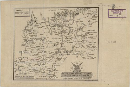
| Title | Acurata delineatio Iasigiae, et utriusque Cumaniae. |
| Main title | A Jászság, Kiskunság és a Nagykunság területének térképe 1802-ben. |
385. L’Ungaria nuouamente descritta, et accresciuta di Varie Noti... [B IX a 496/2]
Institute and Museum of Military History •
B IX a
•
B IX Ausztria–Magyarország
•
B I–XV. Európa
| Title | L’Ungaria nuouamente descritta, et accresciuta di Varie Notizie… |
| Main title | Magyarország térképe 1686-ban. |
386. Mappa Novissima Regnorum Hungariae, Croatiae, Slavoniae nec ... [B IX a 497]
Institute and Museum of Military History •
B IX a
•
B IX Ausztria–Magyarország
•
B I–XV. Európa
| Title | Mappa Novissima Regnorum Hungariae, Croatiae, Slavoniae nec non Magni Principatus Transilvaniae… – Novelle Carte du Royaume de Hongrie de Croatie de Slavonie et de Transylvanie… |
| Main title | A Magyar Királyság, Horvát-Szlavónia és Erdély térképe a 19. század elején. |
387. Mappa Novissima Specialis et Postarum Regnorum Hungariae Cro... [B IX a 497/1]
Institute and Museum of Military History •
B IX a
•
B IX Ausztria–Magyarország
•
B I–XV. Európa
| Title | Mappa Novissima Specialis et Postarum Regnorum Hungariae Croatiae, Slavoniae et Magni Principatus Transylvaniae… – Nouvelle Carte du Royaume de Hongrie de Croatie de Slavonie et de Transylvanie… |
| Main title | A Magyar Királyság, Horvát-Szlavónia és Erdély térképe a 19. század elején. |
388. Karte vom Koenigreiche Ungarn mit Einschluss der Königreiche... [B IX a 498]
Institute and Museum of Military History •
B IX a
•
B IX Ausztria–Magyarország
•
B I–XV. Európa
| Title | Karte vom Koenigreiche Ungarn mit Einschluss der Königreiche Kroazien und Slavonien dann von dem Grossfürstenthume Siebenbürgen. |
| Main title | A Magyar Királyság, Horvát-Szlavónia és Erdély térképe 1809-ben |
389. Allgemeine Charte vom Königreiche Ungarn mit Einschluss der ... [B IX a 498/a]
Institute and Museum of Military History •
B IX a
•
B IX Ausztria–Magyarország
•
B I–XV. Európa
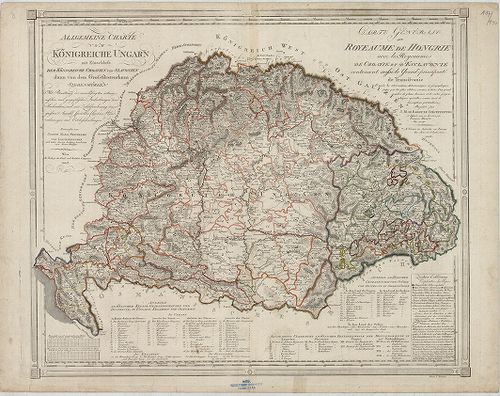
| Title | Allgemeine Charte vom Königreiche Ungarn mit Einschluss der Königreiche Croatien und Slavonien dann von dem Grossfürstenthum Siebenbürgen… – Carte Générale du Royeaume de Hongrie avec les Royaeumes de Croatie et d’Esclavonie contenant aussi le Grand – principauté de Transilvanie… |
| Main title | A Magyar Királyság, Horvátország, Szlavónia, és Erdély térképe 1805-ben, kerületi beosztással. |
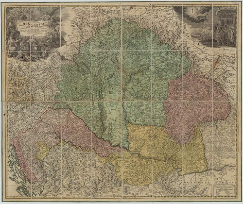
390. Tabula generalis Regni Hungariae, Croatiae et Slavoniae nec ... [B IX a 500]
Institute and Museum of Military History •
B IX a
•
B IX Ausztria–Magyarország
•
B I–XV. Európa
| Title | Tabula generalis Regni Hungariae, Croatiae et Slavoniae nec non Magni Principatus Transylvaniae… |
| Main title | A Magyar Királyság, Horvát-Szlavónia és Erdély általános térképe 1810-ben. Tartományi színezés. |
391. Magyarország térképe Lipsky nagy térképe után jav. [B IX a 500/1]
Institute and Museum of Military History •
B IX a
•
B IX Ausztria–Magyarország
•
B I–XV. Európa
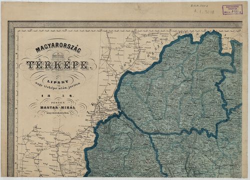
| Title | Magyarország térképe Lipsky nagy térképe után jav. |
392. Königreich Ungarn nach Lipsky. [B IX a 500/2]
Institute and Museum of Military History •
B IX a
•
B IX Ausztria–Magyarország
•
B I–XV. Európa
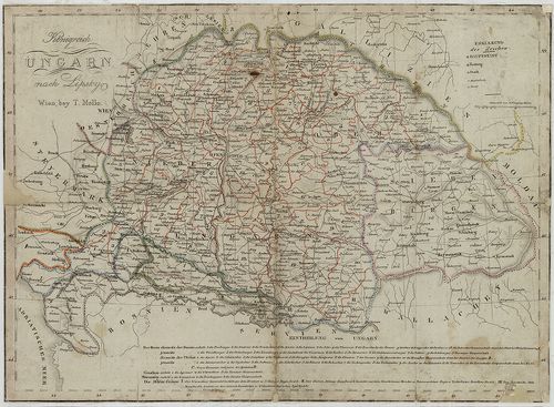
| Title | Königreich Ungarn nach Lipsky. |
| Main title | A Magyar Királyság térképe Lipszky térképe nyomán 1825 körül. |
393. Magyar Országnak és a hozzá kaptsoltatott Horváth, és Tóth O... [B IX a 502]
Institute and Museum of Military History •
B IX a
•
B IX Ausztria–Magyarország
•
B I–XV. Európa
| Title | Magyar Országnak és a hozzá kaptsoltatott Horváth, és Tóth Országoknak, ’s Határőrző katonai vidékeknek ’nem különben az Erdélyi Nagy Fejedelemségnek vármegyékre és Szabad Kerületekre Osztatott ’s a’ leg jobb Mappák szerént készíttetett közönséges táblája… |
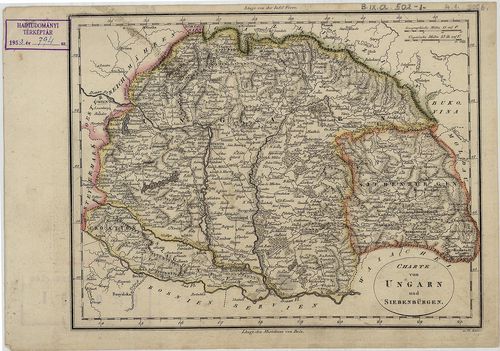
394. Charte von Ungarn und Siebenbürgen. [B IX a 502/1]
Institute and Museum of Military History •
B IX a
•
B IX Ausztria–Magyarország
•
B I–XV. Európa
| Title | Charte von Ungarn und Siebenbürgen. |
| Main title | Magyarország és Erdély térképe a 19. század elején. |
395. Postcharte des Königreiches Ungarn. [B IX a 502/2]
Institute and Museum of Military History •
B IX a
•
B IX Ausztria–Magyarország
•
B I–XV. Európa
| Title | Postcharte des Königreiches Ungarn. |
| Main title | A Magyar Királyság térképe 1808-ban, posta és úthálózattal. |
396. Magyar és Erdélyország Földképe. [B IX a 502/3]
Institute and Museum of Military History •
B IX a
•
B IX Ausztria–Magyarország
•
B I–XV. Európa
| Title | Magyar és Erdélyország Földképe. |
397. Mappa Generalis Topographico-Ecclesiastico-Ethnographico-Sta... [B IX a 506]
Institute and Museum of Military History •
B IX a
•
B IX Ausztria–Magyarország
•
B I–XV. Európa
| Title | Mappa Generalis Topographico-Ecclesiastico-Ethnographico-Statistica Regni Hungariae partiumque adnexarum Croatieae Slavoniae et Confiniorum Militarium Magni item Principatus Transylvaniae. |
| Main title | A Magyar Királyság, Horvát-Szlavónia , a Katonai Határőrvidékek és Erdély általános topográfiai, egyházmegyei, néprajzi, statisztikai térképe 1830–1840-ben. |
398. Mappa Generalis Topographico-Ecclesiastico-Ethnographico-Sta... [B IX a 506/1]
Institute and Museum of Military History •
B IX a
•
B IX Ausztria–Magyarország
•
B I–XV. Európa
| Title | Mappa Generalis Topographico-Ecclesiastico-Ethnographico-Statistica Regni Hungariae partiumque adnexarum Croatiae Slavoniae et Confiniarum Militarium Magni item Principatus Transylvaniae. |
| Main title | A Magyar Királyság, Horvát-Szlavónia , a katőnai Határőrvidékek és Erdély általános topográfiai, egyházmegyei, néprajzi, statisztikai térképe 1830–1840-ben, 1844-es kiadás. |
399. Mappa Generalis Topographico-Ecclesiastico-Ethnographico-Sta... [B IX a 506/2]
Institute and Museum of Military History •
B IX a
•
B IX Ausztria–Magyarország
•
B I–XV. Európa
| Title | Mappa Generalis Topographico-Ecclesiastico-Ethnographico-Statistica Regni Hungariae partiumque adnexarum Croatiae Slavoniae et Confiniarum Militarium Magni item Principatus Transylvaniae. |
| Main title | A Magyar Királyság, Horvát-Szlavónia , a katőnai Határőrvidékek és Erdély általános topográfiai, egyházmegyei, néprajzi, statisztikai térképe 1830–1840-ben, 1844-es kiadás. |
400. Mappa Generalis Topographico-Ecclesiastico-Ethnographico-Sta... [B IX a 506/3]
Institute and Museum of Military History •
B IX a
•
B IX Ausztria–Magyarország
•
B I–XV. Európa
| Title | Mappa Generalis Topographico-Ecclesiastico-Ethnographico-Statistica Regni Hungariae partiumque adnexarum Croatiae Slavoniae et Confiniorum Militarium Magni item Principatus Transylvaniae. |
| Main title | A Magyar Királyság, Horvát-Szlavónia , a katőnai Határőrvidékek és Erdély általános topográfiai, egyházmegyei, néprajzi, statisztikai térképe 1830–1838 között. |