241. Carte vom Kreise Klagenfurthim Herzogthume Kaernshen. [B IX a 304]
Institute and Museum of Military History •
B IX a
•
B IX Ausztria–Magyarország
•
B I–XV. Európa
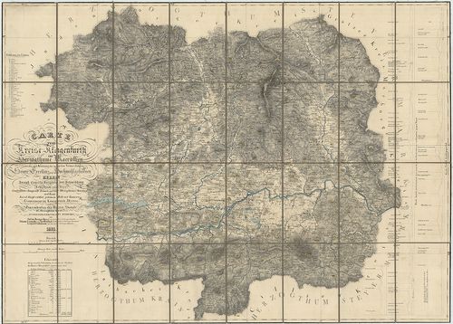
| Title | Carte vom Kreise Klagenfurthim Herzogthume Kaernshen. |
| Main title | A Klagentfurti Körzet térképe a Karintiai Hercegségben 1835-ben. |
242. Übersichtskarte von Kärnten mit den angrenzenden Ländern. [B IX a 305]
Institute and Museum of Military History •
B IX a
•
B IX Ausztria–Magyarország
•
B I–XV. Európa
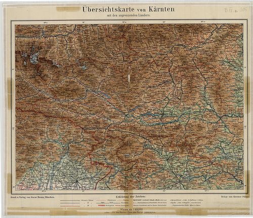
| Title | Übersichtskarte von Kärnten mit den angrenzenden Ländern. |
| Main title | Karintia áttekintő térképe 1910 körül. |
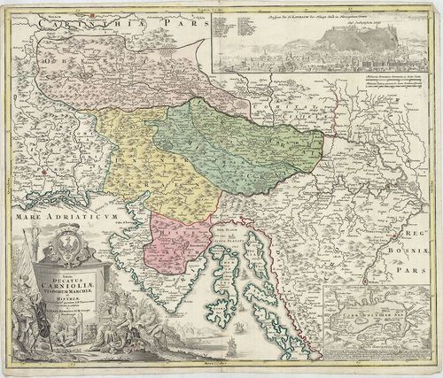
243. Exactissima Ducatus Carniolae Vindorum Marchiä et Historiae… [B IX a 307]
Institute and Museum of Military History •
B IX a
•
B IX Ausztria–Magyarország
•
B I–XV. Európa
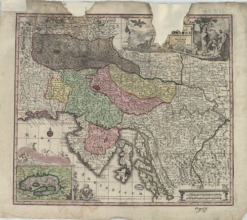
| Title | Exactissima Ducatus Carniolae Vindorum Marchiä et Historiae… |
| Main title | Mt. Czirnitzer See. (Cerknicai tó.) |
| Subject | A Krajnai Hercegség és az Isztriai-félsziget térképe 1730. körül. |
244. Exactissima Ducatus Carniolae Vindorum Marchiä et Historiae… [B IX a 308]
Institute and Museum of Military History •
B IX a
•
B IX Ausztria–Magyarország
•
B I–XV. Európa
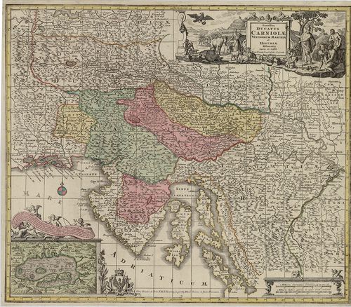
| Title | Exactissima Ducatus Carniolae Vindorum Marchiä et Historiae… |
| Main title | Mt. Czirnitzer See. (Cerknicai-tó.) |
| Subject | A Krajnai Hercegség és az Isztriai-félsziget térképe 1760 körül. |
245. Karte vom Herzogthume Krain. [B IX a 311]
Institute and Museum of Military History •
B IX a
•
B IX Ausztria–Magyarország
•
B I–XV. Európa
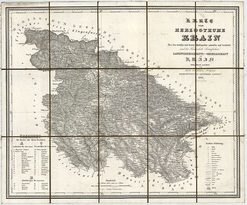
| Title | Karte vom Herzogthume Krain. |
| Main title | A Krajnai Hercegség térképe 1832-ben. |
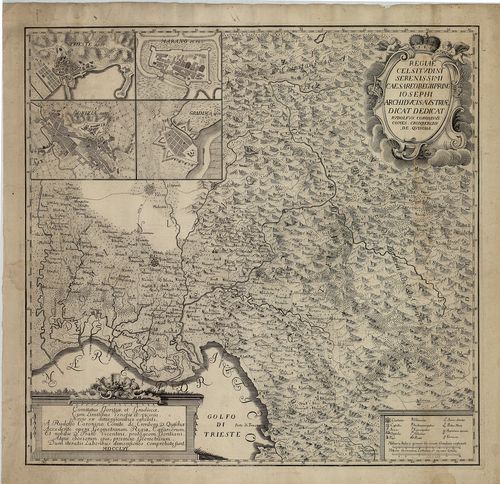
246. Ducatus Carnioliae Tabula Chorographica, jussu sumptuque inc... [B IX a 313]
Institute and Museum of Military History •
B IX a
•
B IX Ausztria–Magyarország
•
B I–XV. Európa
| Title | Ducatus Carnioliae Tabula Chorographica, jussu sumptuque inclytorum Provinciae Statuum geometrice exhibita… |
| Main title | Mt. [Ljubljana város látképe és térk.] |
| Subject | A Krajnai Hercegség térképe 1744-ben. |
247. Tabula Ducatus Carnioliae Vindorum Marchiae et Historiae… [B IX a 314]
Institute and Museum of Military History •
B IX a
•
B IX Ausztria–Magyarország
•
B I–XV. Európa
| Title | Tabula Ducatus Carnioliae Vindorum Marchiae et Historiae… |
| Main title | 2 mt. 1. Cirkhnitzer See. (Cerknicai-tó.) 2. Laybach. (Ljubljana látképe.) |
| Subject | A Krajnai Hercegség és az Isztriai-félsziget térképe 1740 körül. |
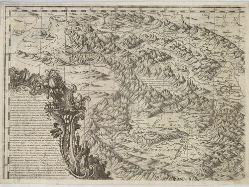
248. Comitatus Goritia, et Gradisca, cum Limitibus Venetis et vic... [B IX a 318]
Institute and Museum of Military History •
B IX a
•
B IX Ausztria–Magyarország
•
B I–XV. Európa
| Title | Comitatus Goritia, et Gradisca, cum Limitibus Venetis et vicinia… |
| Main title | 4 mt. 1. Trieste. 2. Gorizia. 3. Marano (Di Nogaro). 4. Gradisca városok térk. |
| Subject | Krajna: Gorozia, Gradisca és Velence környékének térképe 1756-ban. |
249. Neue topographische Carte von Istrien der Insel Cherso und V... [B IX a 325/1]
Institute and Museum of Military History •
B IX a
•
B IX Ausztria–Magyarország
•
B I–XV. Európa
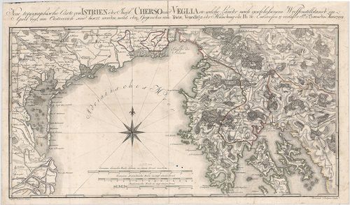
| Title | Neue topographische Carte von Istrien der Insel Cherso und Veglia etc. |
| Main title | Az Isztriai-félsziget, Cherso (Cres) és Veglia (Krk) szigetek térképe 1797-ben. |
250. Nouvelle Carte de l’Istrie. [B IX a 327]
Institute and Museum of Military History •
B IX a
•
B IX Ausztria–Magyarország
•
B I–XV. Európa
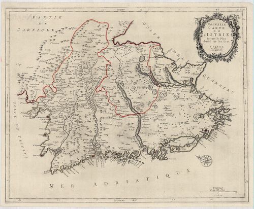
| Title | Nouvelle Carte de l’Istrie. |
| Main title | Az Isztriai-félsziget "új" térképe 1780-ban. |
251. Spezial-Karte des Lombardo – Venezianischen Königreichs. [B IX a 328]
Institute and Museum of Military History •
B IX a
•
B IX Ausztria–Magyarország
•
B I–XV. Európa
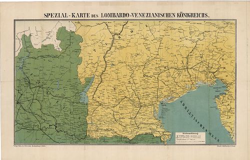
| Title | Spezial-Karte des Lombardo – Venezianischen Königreichs. |
| Main title | A Lombard-Velencei Királyság térképe 1866-ban. |
252. Carte dell Istria. [B IX a 330]
Institute and Museum of Military History •
B IX a
•
B IX Ausztria–Magyarország
•
B I–XV. Európa
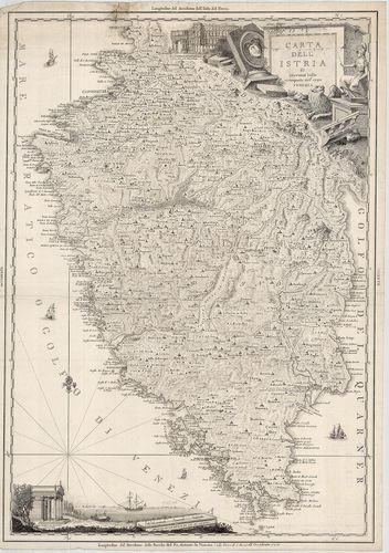
| Title | Carte dell Istria. |
| Main title | Az Isztriai-félsziget térképe 1792-ben. |
253. Tyrolis Comitatus. [B IX a 336]
Institute and Museum of Military History •
B IX a
•
B IX Ausztria–Magyarország
•
B I–XV. Európa
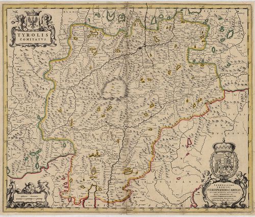
| Title | Tyrolis Comitatus. |
| Main title | A Tirol Grófság térképe a 17. században. |
254. Karte von Tirol, Steyermark und Illyrien. [B IX a 337]
Institute and Museum of Military History •
B IX a
•
B IX Ausztria–Magyarország
•
B I–XV. Európa
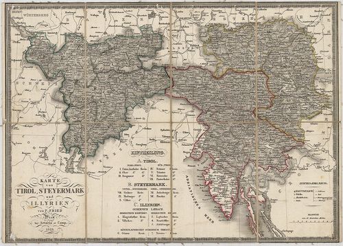
| Title | Karte von Tirol, Steyermark und Illyrien. |
| Main title | Tirol, Stájerország és Illíria térképe 1828-ban. |
255. Tyrol gegen Norden. [B IX a 338]
Institute and Museum of Military History •
B IX a
•
B IX Ausztria–Magyarország
•
B I–XV. Európa
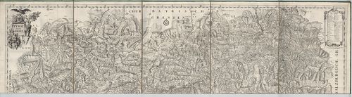
| Title | Tyrol gegen Norden. |
| Main title | Tirol É-i részének térképe a 18. században. |
256. Tyrol gegen Süden. [B IX a 339]
Institute and Museum of Military History •
B IX a
•
B IX Ausztria–Magyarország
•
B I–XV. Európa
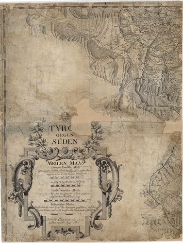
| Title | Tyrol gegen Süden. |
| Main title | Tirol D-i részének térképe a 18. században. |
257. Comitatus Principalis Tirolis in quo Episc. Tribentin et Bri... [B IX a 340]
Institute and Museum of Military History •
B IX a
•
B IX Ausztria–Magyarország
•
B I–XV. Európa
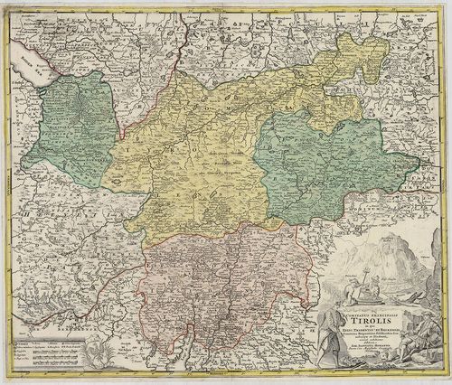
| Title | Comitatus Principalis Tirolis in quo Episc. Tribentin et Brixensis, Comitatus Brigantinus, Feldkirchiae Sonnebergae et Pludentii… |
| Main title | A Tiroli Grófság: Bregenz, Feldkircheni Grófság, Brixen, (Bressanone), Trentoi, Püspökségek térképe 1716-ban. |
258. Karte des Gefürsteten Grafschaft Tyrol. Carte der Tyrol. [B IX a 341]
Institute and Museum of Military History •
B IX a
•
B IX Ausztria–Magyarország
•
B I–XV. Európa
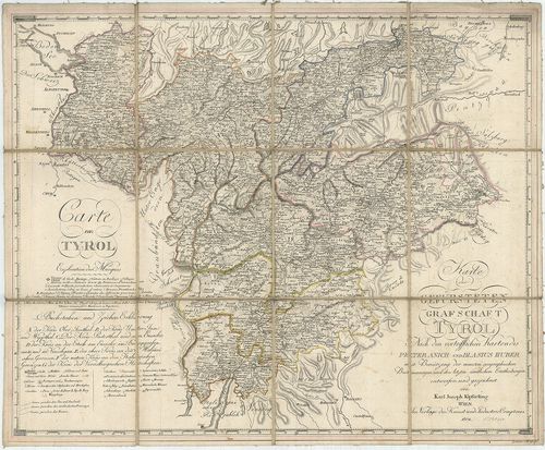
| Title | Karte des Gefürsteten Grafschaft Tyrol. Carte der Tyrol. |
| Main title | A Tiroli Grófság térképe 1804-ben. |
259. Karte der Gefürsteten Grafschaft Tyrol mit Vorarlberg. [B IX a 342]
Institute and Museum of Military History •
B IX a
•
B IX Ausztria–Magyarország
•
B I–XV. Európa
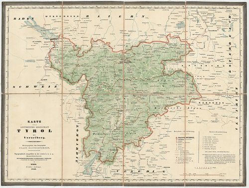
| Title | Karte der Gefürsteten Grafschaft Tyrol mit Vorarlberg. |
| Main title | A Tiroli Grófság és Vorarlberg térképe 1846-ban. |
260. Kreis, – Gerichts, – Völker, – Telegrafen. – und Post-Karte ... [B IX a 343]
Institute and Museum of Military History •
B IX a
•
B IX Ausztria–Magyarország
•
B I–XV. Európa
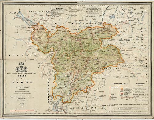
| Title | Kreis, – Gerichts, – Völker, – Telegrafen. – und Post-Karte der Gefürsteten Grafschaft Tyrol mit Vorarlberg. |
| Main title | A Tiroli Grófság és Vorarlberg kerületi, törvénykezési, népességi, távirda és postahálózat térképe 1850-ben. |