321. Handkarte des Herzogthumes Bukowina. [B IX a 424]
Institute and Museum of Military History •
B IX a
•
B IX Ausztria–Magyarország
•
B I–XV. Európa
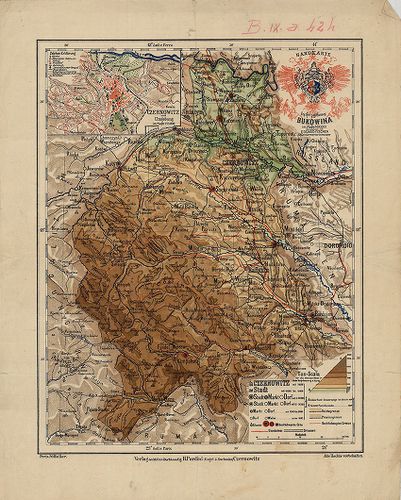
| Title | Handkarte des Herzogthumes Bukowina. |
| Main title | Mt. Czernowitz und Umgebung. (Csernovitz, Csernovci és körny.) |
| Subject | A Bukovina Hercegség, térképe 1890 körül. |
322. [Galícia és Bukovina topográfiai térképe a 19. században.] [B IX a 425]
Institute and Museum of Military History •
B IX a
•
B IX Ausztria–Magyarország
•
B I–XV. Európa
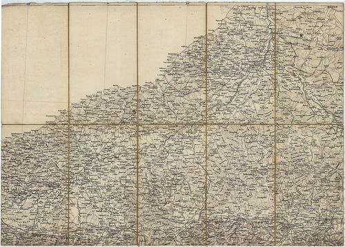
| Title | [Galícia és Bukovina topográfiai térképe a 19. században.] |
323. Carte Bucowiner District. [B IX a 426]
Institute and Museum of Military History •
B IX a
•
B IX Ausztria–Magyarország
•
B I–XV. Európa
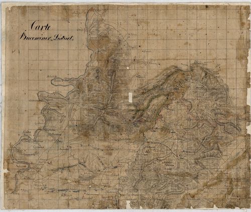
| Title | Carte Bucowiner District. |
| Main title | Bukovina térképe a 18. században. |
324. Verkehrskarte des Herzogtumes Bukowina. [B IX a 429]
Institute and Museum of Military History •
B IX a
•
B IX Ausztria–Magyarország
•
B I–XV. Európa
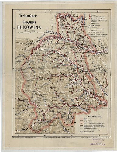
| Title | Verkehrskarte des Herzogtumes Bukowina. |
| Main title | A Bukovina Hercegség közlekedési térképe 1907-ben. |
325. Carta dell’Istria Riveduta et aumentata dol Ceasaero Reggio. [B IX a 440]
Institute and Museum of Military History •
B IX a
•
B IX Ausztria–Magyarország
•
B I–XV. Európa
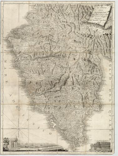
| Title | Carta dell’Istria Riveduta et aumentata dol Ceasaero Reggio. |
| Main title | Az Isztriai-félsziget térképe 1803-ban. |
326. I. Charte des Nordwestlichen Theiles von Dalmatien. – Partie... [B IX a 441]
Institute and Museum of Military History •
B IX a
•
B IX Ausztria–Magyarország
•
B I–XV. Európa
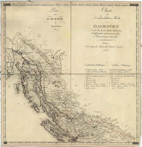
| Title | I. Charte des Nordwestlichen Theiles von Dalmatien. – Partie de la Dalmatie du Nord Quest. II. Charte des Südöstlichen Theiles von Dalmatien mit dem Oesterreichischen Antheile von Albanien. – Partie de la Dalmatie du Sud Est avec l’Albanie. |
| Main title | ÉNY- és DK-Dalmácia térképe Albánia osztrák fennhatóság alatt álló részével 1804-ben. |
327. Carta Novissima della Dalmazia, Albania, Croazia, Bosnia [B IX a 442]
Institute and Museum of Military History •
B IX a
•
B IX Ausztria–Magyarország
•
B I–XV. Európa
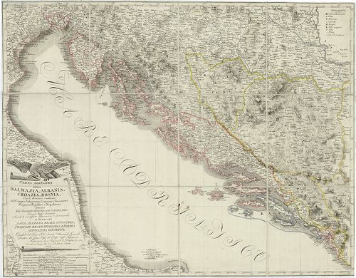
| Title | Carta Novissima della Dalmazia, Albania, Croazia, Bosnia |
| Main title | Dalmácia, Albánia, Horvátország, Bosznia "új" térképe 1806-ban, határjelöléssel. |
328. Carte des Provinces Illyriennes Comprenant La Bosnie, L’Herz... [B IX a 443]
Institute and Museum of Military History •
B IX a
•
B IX Ausztria–Magyarország
•
B I–XV. Európa
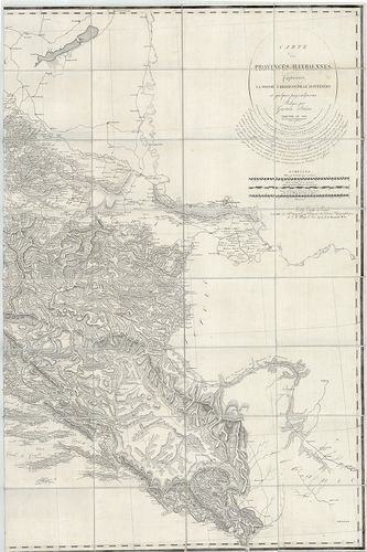
| Title | Carte des Provinces Illyriennes Comprenant La Bosnie, L’Herzegovine, Le Monténero… |
| Main title | Illiria, Bosznia–Hercegovina, Montenegro térképe 1812-ben. |
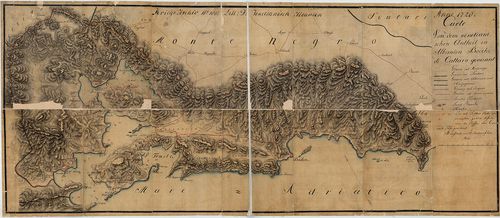
329. 1. Nouvelle Carte de la Partie Occidentale de Dalmatie. – II... [B IX a 446]
Institute and Museum of Military History •
B IX a
•
B IX Ausztria–Magyarország
•
B I–XV. Európa
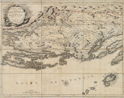
| Title | 1. Nouvelle Carte de la Partie Occidentale de Dalmatie. – II. Nouvelle Carte de la Orientale de Dalmatie. |
| Main title | Mt. Baye ou Bocche di Cattaro. (Kotori-ö.) |
| Subject | Dalmácia NY-i és K-i részének "új" térképe 1780-ban. |
330. Carta prospettiva delle Comuni Censuarie della Dalmazia. [B IX a 450]
Institute and Museum of Military History •
B IX a
•
B IX Ausztria–Magyarország
•
B I–XV. Európa
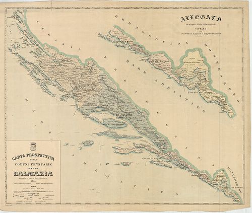
| Title | Carta prospettiva delle Comuni Censuarie della Dalmazia. |
| Main title | Mt. Allegato in doppia Scala del Circolo di Cattaro e dei Distretti di Raguza e Ragusavecchia. (Kataro, Kotor, – Ragusa, Dubrovnik, – Ragusavecchia, Ragusa-Óváros, Cavtat, ker.). |
| Subject | Dalmácia közigazgatási térképe 1853-ban, kerületi beosztással. |
331. G. Freytags Karte der Oesterreichisch–Ungarischen Küstenländ... [B IX a 451]
Institute and Museum of Military History •
B IX a
•
B IX Ausztria–Magyarország
•
B I–XV. Európa
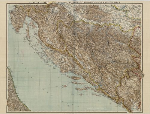
| Title | G. Freytags Karte der Oesterreichisch–Ungarischen Küstenländer. |
| Main title | Az Osztrák-Magyar Monarchia Tengermellék tartományának térképe 1915 körül. |
332. Carte von Dalmatien und dem Gebieth von Ragusa. [B IX a 455]
Institute and Museum of Military History •
B IX a
•
B IX Ausztria–Magyarország
•
B I–XV. Európa
| Title | Carte von Dalmatien und dem Gebieth von Ragusa. |
| Main title | Dalmácia és Raguza (Dubrovnik) térképe 1829-ben. |
333. Special-Karte des Koenigreiches Dalmatien. [B IX a 458]
Institute and Museum of Military History •
B IX a
•
B IX Ausztria–Magyarország
•
B I–XV. Európa
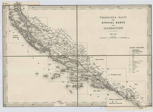
| Title | Special-Karte des Koenigreiches Dalmatien. |
| Main title | Dalmácia részletes térképe 1863-ban, a II. katonai felmérés alapján. |
334. Special-Karte des Koenigreiches Dalmatien. [B IX a 458]
Institute and Museum of Military History •
B IX a
•
B IX Ausztria–Magyarország
•
B I–XV. Európa
| Title | Special-Karte des Koenigreiches Dalmatien. |
335. Carte von dem venetianischen Antheil in Albanien Bocche die ... [B IX a 464]
Institute and Museum of Military History •
B IX a
•
B IX Ausztria–Magyarország
•
B I–XV. Európa
| Title | Carte von dem venetianischen Antheil in Albanien Bocche die Cattaro genannt. |
| Main title | A Cattaroi-öböl (Kotori-öböl) környéke 1720-ban. |
336. Carte des Bouches de Cattaro et du Montenegro. [B IX a 471]
Institute and Museum of Military History •
B IX a
•
B IX Ausztria–Magyarország
•
B I–XV. Európa
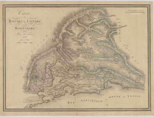
| Title | Carte des Bouches de Cattaro et du Montenegro. |
| Main title | A Cattaroi-öböl (Kotori-öböl) és Montenegró térképe 1830-ban. |
337. Süd-Dalmatien mit den angrenzenden Theilen der Herzegovina u... [B IX a 475]
Institute and Museum of Military History •
B IX a
•
B IX Ausztria–Magyarország
•
B I–XV. Európa
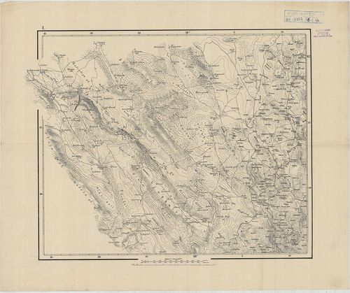
| Title | Süd-Dalmatien mit den angrenzenden Theilen der Herzegovina und Montenegro’s. |
| Main title | Dalmácia D-i részének és a csatlakozó hercegovinai és montenegrói területek topográfiai térképe 1870 körül, Dalmácia 1:144 000 méretarányú részletes térképének felnagyításával. |
338. Karte von dem Königreiche Ungarn mit den Königreichen Kroati... [B IX a 480]
Institute and Museum of Military History •
B IX a
•
B IX Ausztria–Magyarország
•
B I–XV. Európa
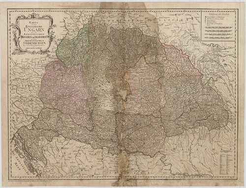
| Title | Karte von dem Königreiche Ungarn mit den Königreichen Kroatien und Sklavonien und dem Grossfürstenthum Siebenbürgen. |
| Main title | A Magyar Királyság, a Horvát-Szlavón Királyság és az Erdélyi Nagyfejedelemség térképe 1796-ban. |
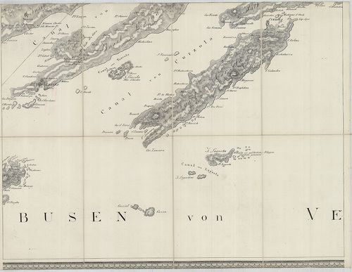
339. Insel Meleda. [B IX a 481]
Institute and Museum of Military History •
B IX a
•
B IX Ausztria–Magyarország
•
B I–XV. Európa
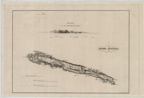
| Title | Insel Meleda. |
| Main title | Mt. Ansicht der Insel Meleda von Nordost. (Meleda, Mljet sziget látképe ÉK-ről) |
| Subject | Meleda-sziget térképe 1825-ben. |
340. A Descript. of Hungary. [B IX a 482/1]
Institute and Museum of Military History •
B IX a
•
B IX Ausztria–Magyarország
•
B I–XV. Európa
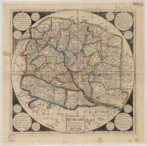
| Title | A Descript. of Hungary. |
| Main title | Magyarország térképe 1700 körül. |