441. Orts und Strassenkarte des Königreiches Ungarn (Mit Inbegrif... [B IX a 525/7]
Institute and Museum of Military History •
B IX a
•
B IX Ausztria–Magyarország
•
B I–XV. Európa
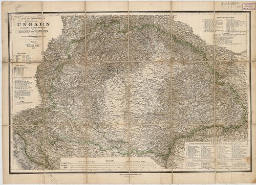
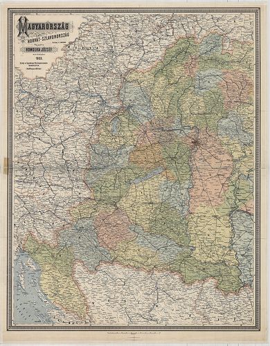
| Title | Orts und Strassenkarte des Königreiches Ungarn (Mit Inbegriff des Ehehmaligen Siebenbürgen) nebst Kroatien und Slavonien. |
| Main title | A Magyar Királyság, Horvát-Szlavónia, Erdély és a katonai határőrvidék térképe 1882-ben, úthálózattal. |
442. General Karte von Königreiche Ungarn und Königreich Kroatien... [B IX a 525/8]
Institute and Museum of Military History •
B IX a
•
B IX Ausztria–Magyarország
•
B I–XV. Európa
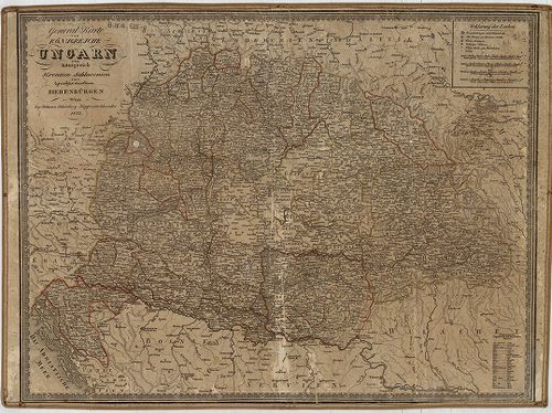
| Title | General Karte von Königreiche Ungarn und Königreich Kroatien Sclavonien samt Grossfürstenthum Sibenbürgen. |
| Main title | A Magyar Királyság, Horvát-Szlavónia, Erdély térképe 1833-ban. |
443. Magyar Állam földképe. [B IX a 525/9]
Institute and Museum of Military History •
B IX a
•
B IX Ausztria–Magyarország
•
B I–XV. Európa
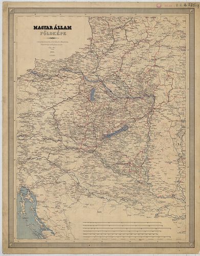
| Title | Magyar Állam földképe. |
444. A Magyar Állam Közigazgatási Térképe. [B IX a 525]
Institute and Museum of Military History •
B IX a
•
B IX Ausztria–Magyarország
•
B I–XV. Európa
| Title | A Magyar Állam Közigazgatási Térképe. |
| Main title | Mt. Budapest, |
445. Magyar Birodalom iskolai faltérképe. Schulwandkarte des Unga... [B IX a 525/10]
Institute and Museum of Military History •
B IX a
•
B IX Ausztria–Magyarország
•
B I–XV. Európa
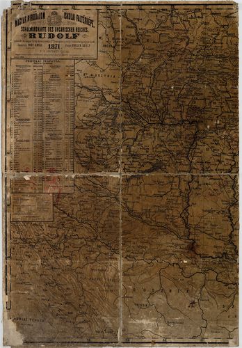
| Title | Magyar Birodalom iskolai faltérképe. Schulwandkarte des Ungarischen Reiches. |
| Main title | Mt. Dalmácia déli része. |
446. Magyarország és Horvát-Szlavonország. [B IX a 525/11]
Institute and Museum of Military History •
B IX a
•
B IX Ausztria–Magyarország
•
B I–XV. Európa
| Title | Magyarország és Horvát-Szlavonország. |
447. Magyarország politikai térképe. [B IX a 525/12]
Institute and Museum of Military History •
B IX a
•
B IX Ausztria–Magyarország
•
B I–XV. Európa
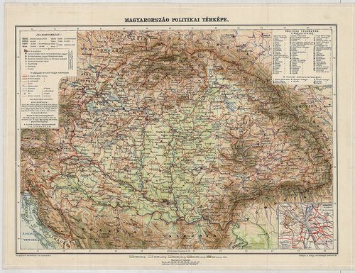
| Title | Magyarország politikai térképe. |
| Main title | Mt. Budapest pályaudvarai. |
448. Sorozat: [B IX a 527]
Institute and Museum of Military History •
B IX a
•
B IX Ausztria–Magyarország
•
B I–XV. Európa
| Title | Sorozat: |
| Main title | Fekete-fehér,eredeti méretű (63x42 cm) fénykép reprodukciók az Osztrák Birodalom I. katonai felméréséből, eredeti változat. 1782-1785. |
449. Kleine Charte des Königreiches Hungarn. [B IX a 528/1a]
Institute and Museum of Military History •
B IX a
•
B IX Ausztria–Magyarország
•
B I–XV. Európa
| Title | Kleine Charte des Königreiches Hungarn. |
| Main title | A Magyar Királyság részletes térképe 1785-ben, az I. katonai felmérés alapján. |
450. „Alapvonal mérései.” Carte von der bey Peterwardein zwischen... [B IX a 529]
Institute and Museum of Military History •
B IX a
•
B IX Ausztria–Magyarország
•
B I–XV. Európa
| Title | „Alapvonal mérései.” Carte von der bey Peterwardein zwischen der Donau, und Theiss befindlichen. Rőmer Schanz, Samt einigen nahe gelegenen Ortschafften, so bey gelegenheit der Anno 1769 in dieser gegend vorgenommen Messung eines Grads der Erde auf der Meridian Linie Trigonometrisch ist aufgenommen worden. |
| Main title | Magyarország: Pétervárad, Petrovaradin, – Csurog, Čurug, – Szeged–Kistelek környékének geodéziai felmérése 1769-ben. (Ott találhatók a római kori sáncok.) |
451. Aufnahmskarte des Königreiches Ungarn. [B IX a 530]
Institute and Museum of Military History •
B IX a
•
B IX Ausztria–Magyarország
•
B I–XV. Európa
| Title | Aufnahmskarte des Königreiches Ungarn. |
| Main title | A II. katonai felmérés szelvényei egyszínű másolatban. |
452. Spezialkarte des Königreiches Ungarn. [B IX a 531]
Institute and Museum of Military History •
B IX a
•
B IX Ausztria–Magyarország
•
B I–XV. Európa
| Title | Spezialkarte des Königreiches Ungarn. |
| Main title | Magyarország részletes térképe a II. katonai felmérés alapján. |
453. Specialkarte des Königreiches Ungarn. [B IX a 531/1]
Institute and Museum of Military History •
B IX a
•
B IX Ausztria–Magyarország
•
B I–XV. Európa
| Title | Specialkarte des Königreiches Ungarn. |
| Main title | Magyarország részletes térképe a II. katonai felmérés alapján.. |
454. Specialkarte des Königreiches Ungarn. [B IX a 531/2]
Institute and Museum of Military History •
B IX a
•
B IX Ausztria–Magyarország
•
B I–XV. Európa
| Title | Specialkarte des Königreiches Ungarn. |
| Main title | Magyarország részletes térképe a II. katonai felmérés alapján.. |
455. Specialkarte des Königreiches Ungarn. 3 album. [B IX a 531/4]
Institute and Museum of Military History •
B IX a
•
B IX Ausztria–Magyarország
•
B I–XV. Európa
| Title | Specialkarte des Königreiches Ungarn. 3 album. |
| Main title | Magyarország részletes térképe a II. katonai felmérés alapján.. |
456. [Magyarország megyéinek (20 vármegye) átnézeti (részletes) t... [B IX a 532]
Institute and Museum of Military History •
B IX a
•
B IX Ausztria–Magyarország
•
B I–XV. Európa
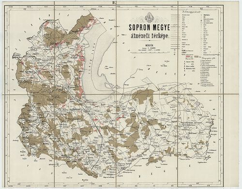
| Title | [Magyarország megyéinek (20 vármegye) átnézeti (részletes) térképe: Sopron, Győr, Veszprém, Vas, Zala, Somogy, Tolna, Baranya, Nógrád, Zólyom, Liptó, Gömör és Kishont, Torna, Abauj, Zemplén, Ung, Beregh (Bereg), Máramaros, Ugocsa, Moson.] |
457. Comitats-Karte von Ungarn. [Magyarország megyéi.] [B IX a 533]
Institute and Museum of Military History •
B IX a
•
B IX Ausztria–Magyarország
•
B I–XV. Európa
| Title | Comitats-Karte von Ungarn. [Magyarország megyéi.] |
| Main title | 1. Bars-vm. 2. Borsod-vm. 3. Esztergom-vm. 4. Hont-vm. 5. Turocz-vm. 6. Neograd-vm. 7. Zólyom-vm. 8. Liptó-vm. 9. A. Abaújvár-vm. B. Torna-vm. 10. Árva-vm. 11. Záránd-vm. 12. A. Közép Szolnok-vm. B. Kraszna-vm. C. Kővár vidéke. |
458. Das Pacshalik von Ofen im Jahre 1650 nach Hadschi Chalfa. [B IX a 535]
Institute and Museum of Military History •
B IX a
•
B IX Ausztria–Magyarország
•
B I–XV. Európa
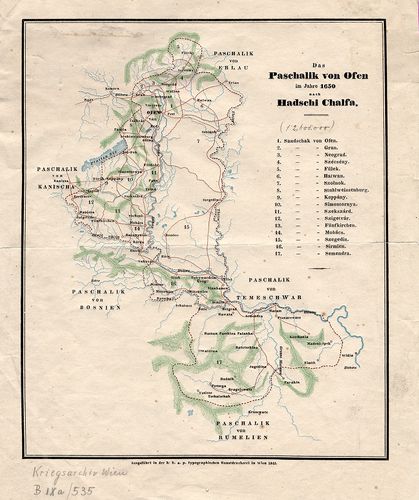
| Title | Das Pacshalik von Ofen im Jahre 1650 nach Hadschi Chalfa. |
| Main title | Magyarország: A budai Ejalet pontos határa, szandzsákok határai és neveik felsorolása 1650-ben. |
459. Tabula Geographica Ungariae Veteris ex Historia Anonym Belae... [B IX a 536]
Institute and Museum of Military History •
B IX a
•
B IX Ausztria–Magyarország
•
B I–XV. Európa
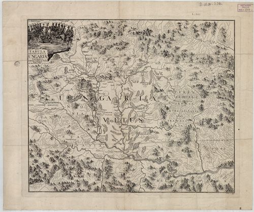
| Title | Tabula Geographica Ungariae Veteris ex Historia Anonym Belae Regis Notarii, 1772. |
| Main title | Magyarország térképe a honfoglalás idején Anonymus leírása alapján. |
460. Mappa Hungariae Inferioris Districtus Cisdanubiani… [B IX a 537]
Institute and Museum of Military History •
B IX a
•
B IX Ausztria–Magyarország
•
B I–XV. Európa
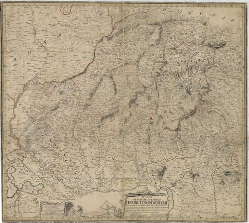
| Title | Mappa Hungariae Inferioris Districtus Cisdanubiani… |
| Main title | É-Magyarország Ny-i részének térképe 1739-ben (pestisjárvány térkép). (Littau, Litovel – Késmárk, Kežmarok – Kapuvár – Jászberény kivágat.) |