801. Mappa Geographica Facta in Ufum Commerciorum „Buda et Baja”. [B IX a 1175]
Institute and Museum of Military History •
B IX a
•
B IX Ausztria–Magyarország
•
B I–XV. Európa
| Title | Mappa Geographica Facta in Ufum Commerciorum „Buda et Baja”. |
| Main title | „Kereskedelmi útvonalak térképe” |
802. A Tabula Hubgariae és változatai. [B IX a 1176]
Institute and Museum of Military History •
B IX a
•
B IX Ausztria–Magyarország
•
B I–XV. Európa
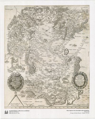
| Title | A Tabula Hubgariae és változatai. |
| Main title | A Lázár és Zsámboky térképek (XVI. sz.) faximile kiadása. |
803. Illyricum. [B IX a 1178]
Institute and Museum of Military History •
B IX a
•
B IX Ausztria–Magyarország
•
B I–XV. Európa
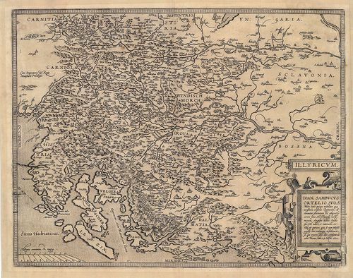
| Title | Illyricum. |
| Main title | Illíria térképe. |
804. Squellette der Aufnahms Carte des Carstadter Generalats in 6... [B IX a 1181]
Institute and Museum of Military History •
B IX a
•
B IX Ausztria–Magyarország
•
B I–XV. Európa
| Title | Squellette der Aufnahms Carte des Carstadter Generalats in 64 Sectionen. |
| Main title | A Károlyvárosi Határőrvidék felmérési szelvényeinek áttekintője az I. katonai felmérés idején. |
805. A Szent Korona országai (1886). [B IX a 1182]
Institute and Museum of Military History •
B IX a
•
B IX Ausztria–Magyarország
•
B I–XV. Európa
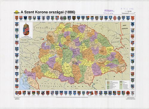
| Title | A Szent Korona országai (1886). |
806. The mape of Hungari....1626. [B IX a 1183]
Institute and Museum of Military History •
B IX a
•
B IX Ausztria–Magyarország
•
B I–XV. Európa
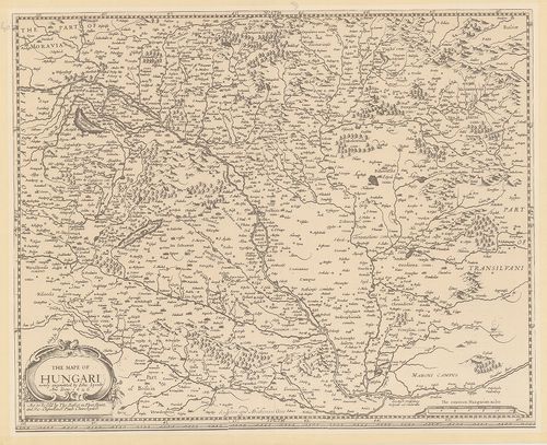
| Title | The mape of Hungari....1626. |
| Main title | Magyarország térképe, 1626. |
807. Regni Hungariae, et Regionum, quae ei quondem fuere unitae. ... [B IX a 1187]
Institute and Museum of Military History •
B IX a
•
B IX Ausztria–Magyarország
•
B I–XV. Európa
| Title | Regni Hungariae, et Regionum, quae ei quondem fuere unitae. ut Transilvaniae, Valachiae, Moldaviae, Serviae, Romaniae, Bulgariae, Bessarabiae, Croatiae, Bosniae, Dalmatiae, Sclavoniae, Morlachiae, Ragusanae, Republicae… |
| Main title | A Magyar Királyság és a Balkán-félsziget térképe 1688-ban. |
808. La Transilvania Diuisa su L’Esemplare delle Carte … [B IX a 1188]
Institute and Museum of Military History •
B IX a
•
B IX Ausztria–Magyarország
•
B I–XV. Európa
| Title | La Transilvania Diuisa su L’Esemplare delle Carte … |
| Main title | Erdély térképe 1686-ban, a nemzetiségi területek megnevezésével. |
809. Ungariae loca praecipua recens emendata atque edita… [B IX a 1189]
Institute and Museum of Military History •
B IX a
•
B IX Ausztria–Magyarország
•
B I–XV. Európa
| Title | Ungariae loca praecipua recens emendata atque edita… |
| Main title | Magyarország térképe 1579-ben. |
810. Carte de la Hongrie a l’Autriche… [B IX a 1190]
Institute and Museum of Military History •
B IX a
•
B IX Ausztria–Magyarország
•
B I–XV. Európa
| Title | Carte de la Hongrie a l’Autriche… |
811. L’Ungaria nuouamente descritta, et accresciuta di Varie Noti... [B IX a 1191]
Institute and Museum of Military History •
B IX a
•
B IX Ausztria–Magyarország
•
B I–XV. Európa
| Title | L’Ungaria nuouamente descritta, et accresciuta di Varie Notizie… |
| Main title | Magyarország térképe 1686-ban. |
812. The mape of Hungari....1626. [B IX a 1192]
Institute and Museum of Military History •
B IX a
•
B IX Ausztria–Magyarország
•
B I–XV. Európa
| Title | The mape of Hungari....1626. |
813. Tabula Hungarie ad quatour latera per Lazarum quondam Thomae... [B IX a 1193]
Institute and Museum of Military History •
B IX a
•
B IX Ausztria–Magyarország
•
B I–XV. Európa
| Title | Tabula Hungarie ad quatour latera per Lazarum quondam Thomae Strigonien Cardin. Secretariu viru, exptuz congesta, á Georgio Tanstetter Collimitio reuisa auctiorqz reddita atque iamprimu á Io. Cuspiniano edita Serenissimo Hungarie et Bohemiae Regi Ferdinando principi et infanti. Hispaniarum Archiduci Austriae ec. Sacra, auspitio maiestatis suae ob reip Christiane vsum, opera Petri Apiani de Leyssnigk Mathematici Ingolstadiani inuulgata Anno Dni 1528. Véste: Collimitius Tanstetter György. |
| Main title | Lázár Magyarország térképének (1528) fakszimile kiadása 2002-ben. |
814. Regni Hungariae et Regionum, quae ei quondam fuere unitae, u... [B IX a 1194]
Institute and Museum of Military History •
B IX a
•
B IX Ausztria–Magyarország
•
B I–XV. Európa
| Title | Regni Hungariae et Regionum, quae ei quondam fuere unitae, ut Transilvaniae, Valachiae, Moldaviae, Serviae, Romaniae, Bulgariae, Bessarábiae, Croatiae, Bosniae, Dalmatiae, Sclavoniae, Morlachiae, Ragusanae Republicae Maximaequ Partis Danubii Fluminis. |
| Main title | A Magyar Királyság és a környező államok (Duna menti országok) térképe 1688-ban. |
815. Regnum Hungaria in Omnes suos Comitatus Accurate... [B IX a 1195]
Institute and Museum of Military History •
B IX a
•
B IX Ausztria–Magyarország
•
B I–XV. Európa
| Title | Regnum Hungaria in Omnes suos Comitatus Accurate... |
| Main title | A Magyar Királyság térképe a XVII. sz. végén, megyebeosztással. |
816. Danubius, Fluvius Europae maximus. A Fontibus ad Ostia. [B IX a 1196]
Institute and Museum of Military History •
B IX a
•
B IX Ausztria–Magyarország
•
B I–XV. Európa
| Title | Danubius, Fluvius Europae maximus. A Fontibus ad Ostia. |
| Main title | A Duna, Európa nagy folyójának térképe. Az eredettől a torkolatig. |
817. A Magyar Szent Korona országainak települései és közigazgatá... [B IX a 1198]
Institute and Museum of Military History •
B IX a
•
B IX Ausztria–Magyarország
•
B I–XV. Európa
| Title | A Magyar Szent Korona országainak települései és közigazgatása. Hátoldalán: Magyarország az Osztrák-Magyar Monarchiában. |
818. Das Khynigreich Hungern... [B IX a 1199]
Institute and Museum of Military History •
B IX a
•
B IX Ausztria–Magyarország
•
B I–XV. Európa
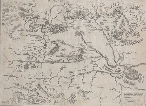
| Title | Das Khynigreich Hungern... |
| Main title | A Magyar Királyság. Az 1566-os török hadjárat főbb várostromainak bemutatása. |
819. Regni Hungariae cum adiuncta Transylvania... [B IX a 1200]
Institute and Museum of Military History •
B IX a
•
B IX Ausztria–Magyarország
•
B I–XV. Európa
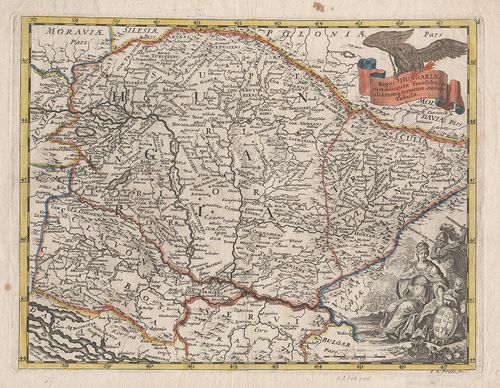
| Title | Regni Hungariae cum adiuncta Transylvania... |
| Main title | A Magyar Királyság és Erdély térképe. |
820. Carte von Ungarn und Siebenbürgen. [B IX a 1201]
Institute and Museum of Military History •
B IX a
•
B IX Ausztria–Magyarország
•
B I–XV. Európa
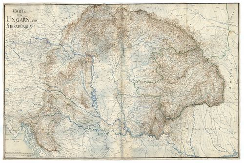
| Title | Carte von Ungarn und Siebenbürgen. |
| Main title | A Magyar Királyság és Erdély térképe. |