781. Tractus Unnae fl. inter Novi et Asperkanova Kula, Burgar, Tu... [B IX a 1152]
Institute and Museum of Military History •
B IX a
•
B IX Ausztria–Magyarország
•
B I–XV. Európa
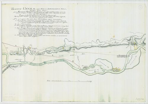
| Title | Tractus Unnae fl. inter Novi et Asperkanova Kula, Burgar, Turcis, dictam... |
| Main title | Az Una folyó Novi és a törökök által Burgar-nak nevezett Asperkanova Kula között. |
782. [Az Una folyó egy szakasza, Novi és környéke.] [B IX a 1153]
Institute and Museum of Military History •
B IX a
•
B IX Ausztria–Magyarország
•
B I–XV. Európa
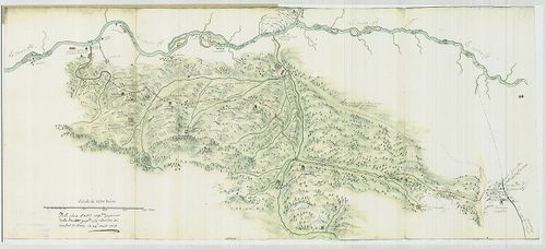
| Title | [Az Una folyó egy szakasza, Novi és környéke.] |
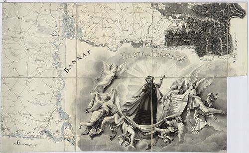
783. Le Grand Royaume de Hongrie… [B IX a 1154]
Institute and Museum of Military History •
B IX a
•
B IX Ausztria–Magyarország
•
B I–XV. Európa
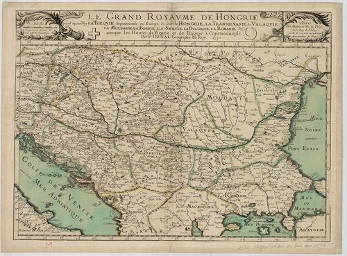
| Title | Le Grand Royaume de Hongrie… |
| Main title | A Magyar Királyság térképe. |
784. Regnum Hungariae cum consignis regionibus. [B IX a 1156]
Institute and Museum of Military History •
B IX a
•
B IX Ausztria–Magyarország
•
B I–XV. Európa
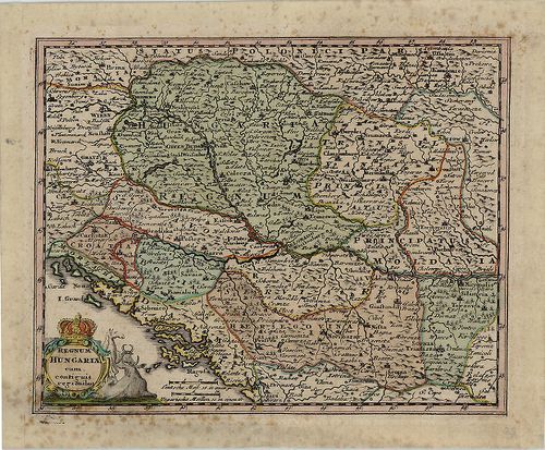
| Title | Regnum Hungariae cum consignis regionibus. |
| Main title | A Magyar Királyság a szomszédos területekkel. |
785. Nejtarsi mapy Moravy. The oldest map of Moravia. 5 kül. térk... [B IX a 1157]
Institute and Museum of Military History •
B IX a
•
B IX Ausztria–Magyarország
•
B I–XV. Európa
| Title | Nejtarsi mapy Moravy. The oldest map of Moravia. 5 kül. térkép. 1–2. Fabricus. Marchionatus Moraviae. 1569. Ua. újrakiadása: 1573. 3. Comenius. Moraviae 1645. 4. Vischer: Moravia… 1692. 5. Müller: Tabula Generalis Marchionatus Moraviae. 1716. |
| Main title | Morvaország régi térképeken. Hasonmás kiadás. |
786. Reinzeichnung einzeiner Blätter des nörlichen Teiles von Sie... [B IX a 1158]
Institute and Museum of Military History •
B IX a
•
B IX Ausztria–Magyarország
•
B I–XV. Európa
| Title | Reinzeichnung einzeiner Blätter des nörlichen Teiles von Siebenbürgen. |
| Main title | Erdély északi részének II. katonai felméréséből származó szelvények. |
787. Karte von Hungarn. [B IX a 1159]
Institute and Museum of Military History •
B IX a
•
B IX Ausztria–Magyarország
•
B I–XV. Európa
| Title | Karte von Hungarn. |
| Main title | Magyarország térképe az I. katonai felmérés alapján, a Neu térképhez hasonló. |
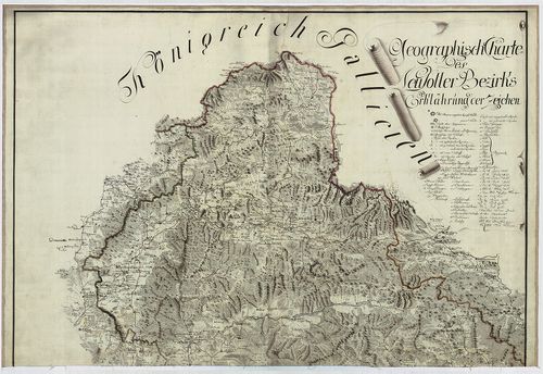
788. Karte des Königreiches Galizien. [B IX a 1160]
Institute and Museum of Military History •
B IX a
•
B IX Ausztria–Magyarország
•
B I–XV. Európa
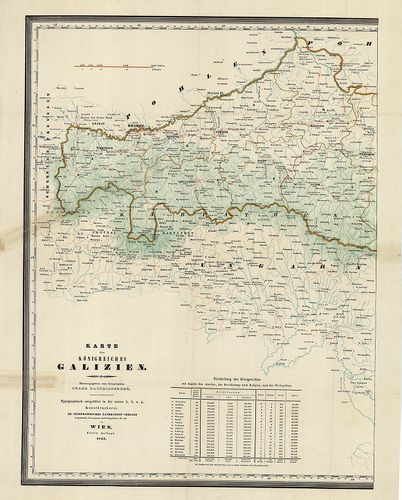
| Title | Karte des Königreiches Galizien. |
| Main title | A Galíciai Királyság térképe. |
789. [A Magyar Királyság és a határoló országok térképe. Az I. ka... [B IX a 1161]
Institute and Museum of Military History •
B IX a
•
B IX Ausztria–Magyarország
•
B I–XV. Európa
| Title | [A Magyar Királyság és a határoló országok térképe. Az I. kat. felm. alapján készült térkép, befejezetlen.] |
790. [Photographische Kopien der Militar-Aufnahms-Sectionen von S... [B IX a 1163]
Institute and Museum of Military History •
B IX a
•
B IX Ausztria–Magyarország
•
B I–XV. Európa
| Title | [Photographische Kopien der Militar-Aufnahms-Sectionen von Siebenbürgen.] |
| Main title | Erdély II. katonai felmérésének másolatai. Sorozat. |
791. Slovénija na vojaskem zemljevidu 1763-1787. I-VII. kötet. [B IX a 1164]
Institute and Museum of Military History •
B IX a
•
B IX Ausztria–Magyarország
•
B I–XV. Európa
| Title | Slovénija na vojaskem zemljevidu 1763-1787. I-VII. kötet. |
| Main title | Szlovénia mai területére eső I. katonai felmérés szelvényei, a hozzátartozó országleírásokkal. |
792. Der Temesvarer Bannat. [B IX a 1166]
Institute and Museum of Military History •
B IX a
•
B IX Ausztria–Magyarország
•
B I–XV. Európa
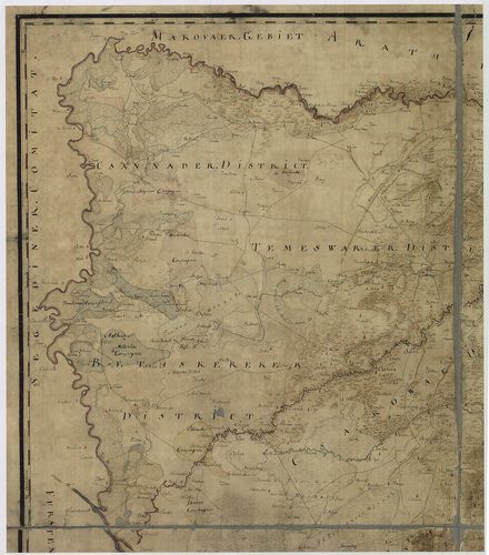
| Title | Der Temesvarer Bannat. |
| Main title | A Temesi Bánság térképe, melynek felmérését Szavoyai Jenő irányította. |
793. Österreich–Ungarn, Übersicht. [B IX a 1167]
Institute and Museum of Military History •
B IX a
•
B IX Ausztria–Magyarország
•
B I–XV. Európa
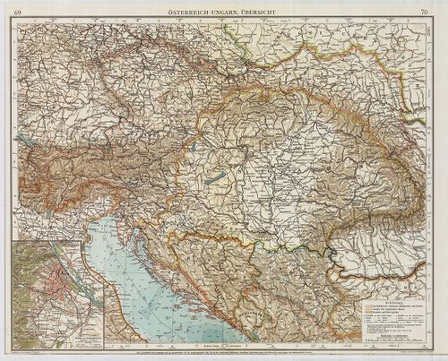
| Title | Österreich–Ungarn, Übersicht. |
| Main title | Az Osztrák–Magyar Monarchia áttekintő térképe. Az „Andrees Allgemeines Handatlas” 69–70. o. nagyítva. |
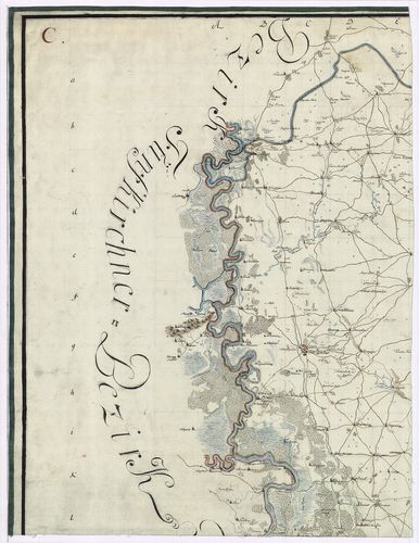
794. Geographische Charte des Neutraer Bezirkes. [B IX a 1168]
Institute and Museum of Military History •
B IX a
•
B IX Ausztria–Magyarország
•
B I–XV. Európa
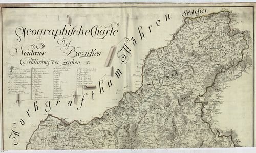
| Title | Geographische Charte des Neutraer Bezirkes. |
| Main title | A Nyitrai kerület földrajzi térképe az I. katonai felmérés alapján. |
795. Charten des Warasdiner Generalats. [B IX a 1169]
Institute and Museum of Military History •
B IX a
•
B IX Ausztria–Magyarország
•
B I–XV. Európa
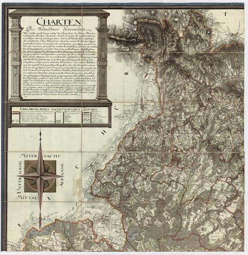
| Title | Charten des Warasdiner Generalats. |
| Main title | A Varasdi Határőrvidék levezetett térképe az I. katonai felmérés alapján. |
796. Geographische Charte des Neusoller Bezirks. [B IX a 1170]
Institute and Museum of Military History •
B IX a
•
B IX Ausztria–Magyarország
•
B I–XV. Európa
| Title | Geographische Charte des Neusoller Bezirks. |
| Main title | A Besztercebányai kerület földrajzi térképe az I. katonai felmérés alapján. |
797. Militair Charte der Banal Grenze… [B IX a 1171]
Institute and Museum of Military History •
B IX a
•
B IX Ausztria–Magyarország
•
B I–XV. Európa

| Title | Militair Charte der Banal Grenze… |
| Main title | A Báni Határőrvidék katonai térképe az I. kat. felm. alapján. |
798. Charte des Carlstaedter Generalats … [B IX a 1172]
Institute and Museum of Military History •
B IX a
•
B IX Ausztria–Magyarország
•
B I–XV. Európa

| Title | Charte des Carlstaedter Generalats … |
| Main title | A Károlyvárosi katonai térképe az I. kat. felm. alapján. |
799. Mappa von Provincial Croatien. [B IX a 1173]
Institute and Museum of Military History •
B IX a
•
B IX Ausztria–Magyarország
•
B I–XV. Európa
| Title | Mappa von Provincial Croatien. |
| Main title | Horvátország térképe az I. kat. felm. alapján. |
800. Geographische Charte des Temeswarer Bezirks … [B IX a 1174]
Institute and Museum of Military History •
B IX a
•
B IX Ausztria–Magyarország
•
B I–XV. Európa
| Title | Geographische Charte des Temeswarer Bezirks … |
| Main title | A Temesvári kerület földrajzi térképe az I. kat. felm. alapján. |