301. [Európa rádióállomásai.] [B I c 102/a]
Institute and Museum of Military History •
B I c
•
B I Európa
•
B I–XV. Európa
| Title | [Európa rádióállomásai.] |
302. [A világ rádióállomásai] [B I c 102/b]
Institute and Museum of Military History •
B I c
•
B I Európa
•
B I–XV. Európa

| Title | [A világ rádióállomásai] |
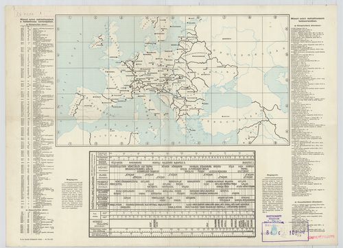
303. Európa rádióadó-állomásainak hullámhossz, kilowatt- és távol... [B I c 103]
Institute and Museum of Military History •
B I c
•
B I Európa
•
B I–XV. Európa
| Title | Európa rádióadó-állomásainak hullámhossz, kilowatt- és távolsági térképe. |
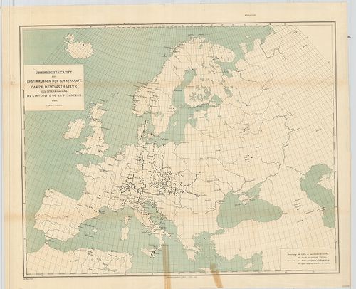
304. Übersichtskarte der Breiten- und Azimutbestimmungen. Carte d... [B I c 120]
Institute and Museum of Military History •
B I c
•
B I Európa
•
B I–XV. Európa
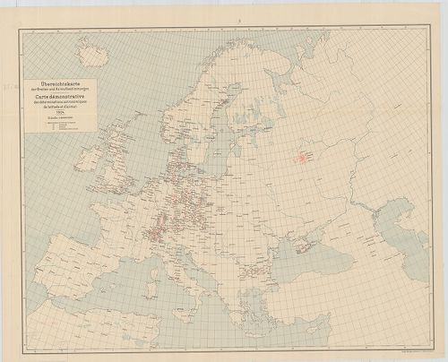
| Title | Übersichtskarte der Breiten- und Azimutbestimmungen. Carte demonstrative des déterminations astronomiques de latitude et d’azimut. 1904. |
| Main title | Európa térképe a földr. szélesség és azimut meghatározásokkal 1904-ben. |
305. Übersichtskarte der telegraphischen Längenbestimmungen. Cart... [B I c 121]
Institute and Museum of Military History •
B I c
•
B I Európa
•
B I–XV. Európa
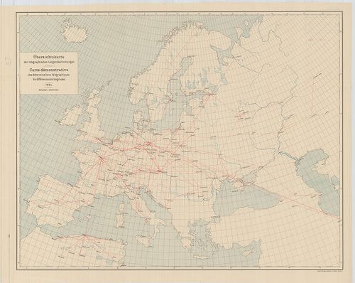
| Title | Übersichtskarte der telegraphischen Längenbestimmungen. Carte démonstrative des déterminations télégraphiques dex différences de longitudes. 1904. |
| Main title | Európa távíró vonalai 1904-ben. |
306. Übersichtskarte der Bestimmungen der Schwerkraft. Carte demo... [B I c 122]
Institute and Museum of Military History •
B I c
•
B I Európa
•
B I–XV. Európa
| Title | Übersichtskarte der Bestimmungen der Schwerkraft. Carte demonstrative des déterminations de lintensité de la pesanteur. |
| Main title | Európa térképe a meghatározott nehézségi erővel 1900-ban. |
307. Übersichtskarte für den Stand der Trigonometrischen Arbeiten... [B I c 123]
Institute and Museum of Military History •
B I c
•
B I Európa
•
B I–XV. Európa
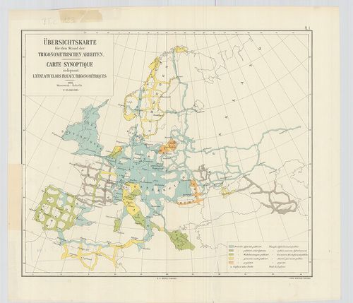
| Title | Übersichtskarte für den Stand der Trigonometrischen Arbeiten. Carte synoptique indiquant l’état actuel des travaux trigonométriques. |
| Main title | Európa térképe a háromszögelési munkák állásáról 1904-ben. |
308. Europe. Europa Mobil. [B I c 125]
Institute and Museum of Military History •
B I c
•
B I Európa
•
B I–XV. Európa
| Title | Europe. Europa Mobil. |
| Main title | Európa autóúttérképe. |
309. Grandes routes de trafic international. Routes de trafic nat... [B I c 126]
Institute and Museum of Military History •
B I c
•
B I Európa
•
B I–XV. Európa
| Title | Grandes routes de trafic international. Routes de trafic national. [Európa.] |
| Main title | Európa autóúttérképe. |
310. Klimaticseszkaja karta Evropü. Ucsebnaja karta. [B I c 127]
Institute and Museum of Military History •
B I c
•
B I Európa
•
B I–XV. Európa
| Title | Klimaticseszkaja karta Evropü. Ucsebnaja karta. |
| Main title | Európa éghajlati térképe. |
311. Prirodnüe zonü Evropü. Ucsebnaja karta. [B I c 128]
Institute and Museum of Military History •
B I c
•
B I Európa
•
B I–XV. Európa
| Title | Prirodnüe zonü Evropü. Ucsebnaja karta. |
| Main title | Európa természeti zónái. |
312. [Európa állatföldrajzi térképe.] [B I c 133]
Institute and Museum of Military History •
B I c
•
B I Európa
•
B I–XV. Európa
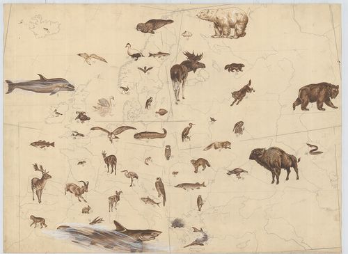
| Title | [Európa állatföldrajzi térképe.] |
313. Europa. Strassenatlas. [B I c 134]
Institute and Museum of Military History •
B I c
•
B I Európa
•
B I–XV. Európa
| Title | Europa. Strassenatlas. |
| Main title | Európa autóatlasza 1969-ben. |
314. Europa, mapa samochodowa. [B I c 135]
Institute and Museum of Military History •
B I c
•
B I Európa
•
B I–XV. Európa
| Title | Europa, mapa samochodowa. |
| Main title | 26 mt.: városáthajtási térképek. |
| Subject | Európa autóúttérképe 1965-ben. |
315. Evropa glavni avtomobilni putisa. [B I c 136]
Institute and Museum of Military History •
B I c
•
B I Európa
•
B I–XV. Európa
| Title | Evropa glavni avtomobilni putisa. |
| Main title | Európa autóúttérképe 1967-ben. |
316. Europa. Hospodařská mapa. [B I c 137]
Institute and Museum of Military History •
B I c
•
B I Európa
•
B I–XV. Európa
| Title | Europa. Hospodařská mapa. |
| Main title | 5 mt.: 1. Donecká panev. (A Dón-medence) 2. Ludnatost (Népsűrűség.) 3. Porúři, (Düsseldorf és környéke.) 4. Štředni Anglie. (Közép-Anglia) 5. Ostravsko-Karvinska a Hornoslezská panev. (Ostrava-Karviná és Hornoslezská-medence.) |
| Subject | Európa gazdaségi térképe 1961-ben. |
317. Europa carta stradale igda-turist. [B I c 138]
Institute and Museum of Military History •
B I c
•
B I Európa
•
B I–XV. Európa
| Title | Europa carta stradale igda-turist. |
| Main title | Európa autóúttérképe. |
318. Carta automobilistica d’Europa – Touring Club Haliano. [B I c 139]
Institute and Museum of Military History •
B I c
•
B I Európa
•
B I–XV. Európa
| Title | Carta automobilistica d’Europa – Touring Club Haliano. |
| Main title | Európa autóúttérképe 1965-ből. |
319. Imperium Romanum. [B I c 140]
Institute and Museum of Military History •
B I c
•
B I Európa
•
B I–XV. Európa
| Title | Imperium Romanum. |
| Main title | 1 mt.: Naše Krajiny |
| Subject | Csehország tartományi része a Római Birodalom idején. |
320. Übersichtskarte der Eisenbahnen in Europa. [B I c 141]
Institute and Museum of Military History •
B I c
•
B I Európa
•
B I–XV. Európa
| Title | Übersichtskarte der Eisenbahnen in Europa. |
| Main title | Mt.: Európa-Asien. |
| Subject | Európa vasúthálózati áttekintő térképe. |
321. Politisch-Geographische Grundlagen Europas-Flemming Friedens... [B I c 142]
Institute and Museum of Military History •
B I c
•
B I Európa
•
B I–XV. Európa
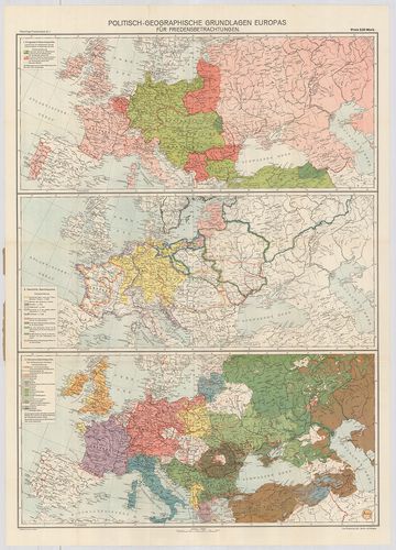
| Title | Politisch-Geographische Grundlagen Europas-Flemming Friedenskarten |
| Main title | 3 térk. 1. Európa háborús térkép 2. Európa történelmi térkép 3. Európa népességi térkép. |
| Subject | Európa politikai-földrajzi térképe 1917-ben. |
322. Európai háború kis térképe. [B I c 143]
Institute and Museum of Military History •
B I c
•
B I Európa
•
B I–XV. Európa
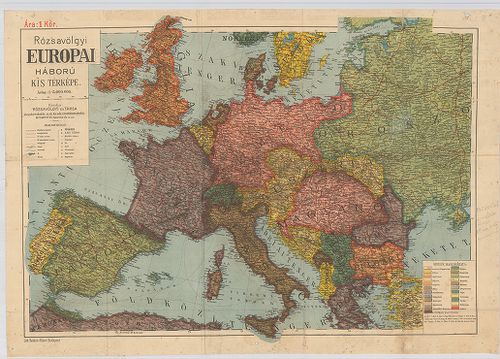
| Title | Európai háború kis térképe. |
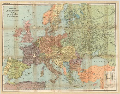
323. Flemmings Übersichtskarte für den europäischen Kriegsschaupa... [B I c 144]
Institute and Museum of Military History •
B I c
•
B I Európa
•
B I–XV. Európa
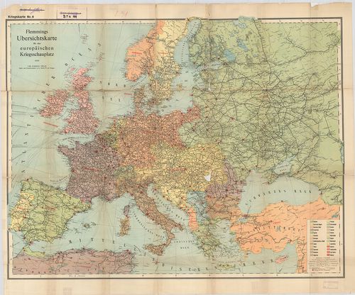
| Title | Flemmings Übersichtskarte für den europäischen Kriegsschaupaltz. |
| Main title | Az európai hadszíntér áttekintő térképe az első világháborúban. |
324. Ravensteins Karte des Deutschen Sperrgebietes für den uneing... [B I c 145]
Institute and Museum of Military History •
B I c
•
B I Európa
•
B I–XV. Európa
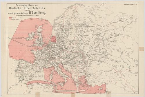
| Title | Ravensteins Karte des Deutschen Sperrgebietes für den uneingeschkränkten „U” Boot-Krieg. Ravensteins Kriegskarte. |
| Main title | Európa térképe. Tengeralattjáró háború a németek által korlátlanul lezárt Európa NY-i és D-i területein. |
325. Europa világháború térképe. [B I c 146]
Institute and Museum of Military History •
B I c
•
B I Európa
•
B I–XV. Európa
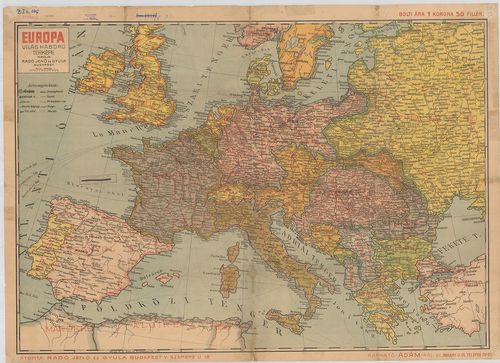
| Title | Europa világháború térképe. |
326. Mittelbach’s Billige Kriegskarte von Europa mit den angrenze... [B I c 147]
Institute and Museum of Military History •
B I c
•
B I Európa
•
B I–XV. Európa
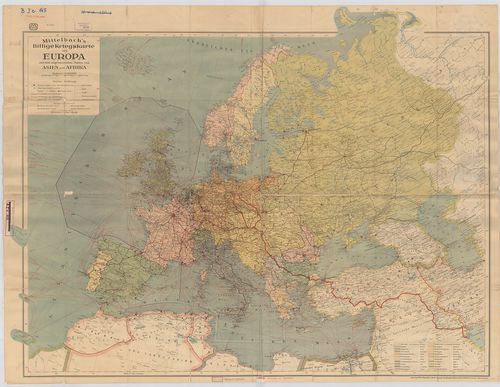
| Title | Mittelbach’s Billige Kriegskarte von Europa mit den angrenzenden Teilen von Asien und Afrika. |
| Main title | Európa háború tárképe Ázsia és Afrika határterületeivel. |
327. Staaten und Verkehrskarte von Europa. [B I c 148]
Institute and Museum of Military History •
B I c
•
B I Európa
•
B I–XV. Európa
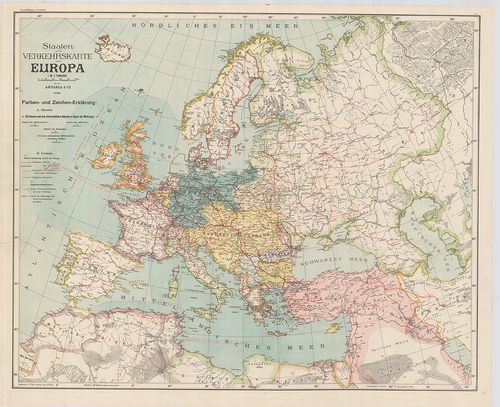
| Title | Staaten und Verkehrskarte von Europa. |
| Main title | Az európai államok közlekedési térképe. |
328. Osnovni projekt buduce Evrope prema politickom stanju i naci... [B I c 149]
Institute and Museum of Military History •
B I c
•
B I Európa
•
B I–XV. Európa
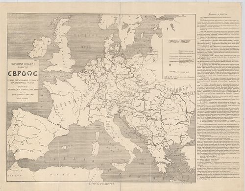
| Title | Osnovni projekt buduce Evrope prema politickom stanju i nacionalnoj teznji. |
| Main title | Tervezet Európa jövőjéről, politikai helyzet és nemzetiségi megosztás. |
329. Karte des Weltkrieges. Europäischer Kriegsschauplatz. [B I c 150]
Institute and Museum of Military History •
B I c
•
B I Európa
•
B I–XV. Európa
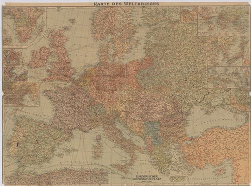
| Title | Karte des Weltkrieges. Europäischer Kriegsschauplatz. |
| Main title | 9 mt.: 1.) Die Deutschen Kolonien in Afrika, and ihre Umwelt. (Német gyarmatok Afrikában.) |
| Subject | 2.) Paris mit seinen Festungswerken. (Páris és erődítései.) |
330. Flemmongs Übersichtskarte für den europäischen Kriegsschaupl... [B I c 151]
Institute and Museum of Military History •
B I c
•
B I Európa
•
B I–XV. Európa
| Title | Flemmongs Übersichtskarte für den europäischen Kriegsschauplatz. No. 9. |
| Main title | Az európai hadszíntér átnézeti térképe. |
331. Navigationskarte für Luftfahrzenge. [B I c 152]
Institute and Museum of Military History •
B I c
•
B I Európa
•
B I–XV. Európa
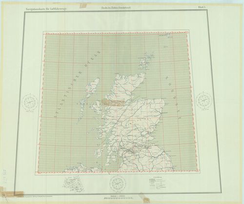
| Title | Navigationskarte für Luftfahrzenge. |
| Main title | Fokhálózatos navigációs térkép légi járművek számára Európa fölött Angliától a Közel-Keletig terjedő térségben. |
332. Humorist. Darstellung der Wappen unserer Feinde 1914. [B I c 153]
Institute and Museum of Military History •
B I c
•
B I Európa
•
B I–XV. Európa

| Title | Humorist. Darstellung der Wappen unserer Feinde 1914. |
| Main title | Az ellenséges hatalmak arcképcímereinek karikatúra-vázlatai. |
333. A háborús európa térkép-karikatúrája. [B I c 154]
Institute and Museum of Military History •
B I c
•
B I Európa
•
B I–XV. Európa
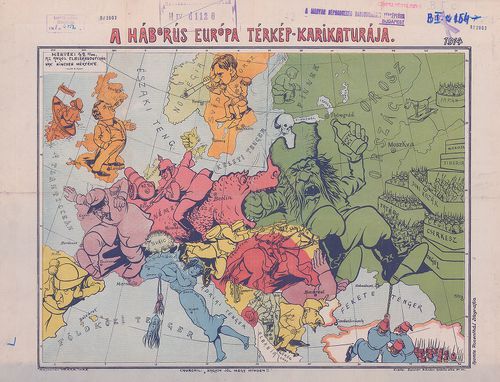
| Title | A háborús európa térkép-karikatúrája. |
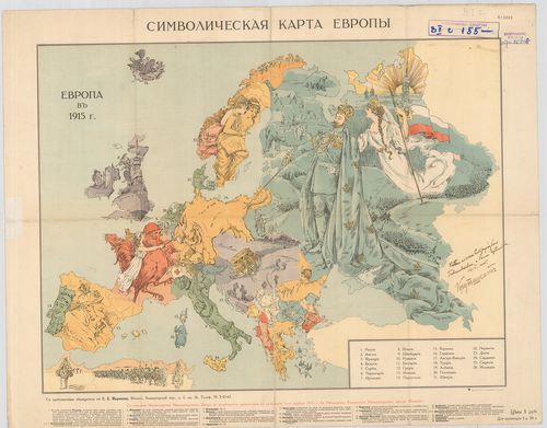
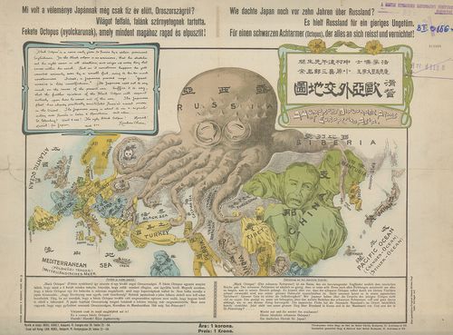
334. Szimbolicseszkaja karta Evropi. [B I c 155]
Institute and Museum of Military History •
B I c
•
B I Európa
•
B I–XV. Európa
| Title | Szimbolicseszkaja karta Evropi. |
| Main title | Jelképes karikatúra-térképe a háborús Európáról. |
335. A Humorous Diplomatic Atlas of Europe and Asia. [B I c 156]
Institute and Museum of Military History •
B I c
•
B I Európa
•
B I–XV. Európa
| Title | A Humorous Diplomatic Atlas of Europe and Asia. |
| Main title | Politikai karikatúra térkép Európáról és Ázsiáról. |
336. Von grossem Sammelwert’. – „Hark! Hark! The dogs do bark.” [B I c 157]
Institute and Museum of Military History •
B I c
•
B I Európa
•
B I–XV. Európa
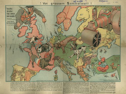
| Title | Von grossem Sammelwert’. – „Hark! Hark! The dogs do bark.” |
| Main title | Európai gúnytérkép. |
337. Die Militärischen Operationen in Europa. 1939–1945. – Les Op... [B I c 158]
Institute and Museum of Military History •
B I c
•
B I Európa
•
B I–XV. Európa
| Title | Die Militärischen Operationen in Europa. 1939–1945. – Les Operations militaries en Europe. The military operations in Europe. 1939–1945. |
| Main title | Hadmozdulatok Európában 1939–1945-ig. |
338. Europa Auto-Atlas. Mit Ortsverzeichnos. 24. kiad. [B I c 159]
Institute and Museum of Military History •
B I c
•
B I Európa
•
B I–XV. Európa
| Title | Europa Auto-Atlas. Mit Ortsverzeichnos. 24. kiad. |
| Main title | Európa autóatlasza. |
339. Az Európai fokmérésnél alapul szolgáló Astronomiai és Geodet... [B I c 160]
Institute and Museum of Military History •
B I c
•
B I Európa
•
B I–XV. Európa
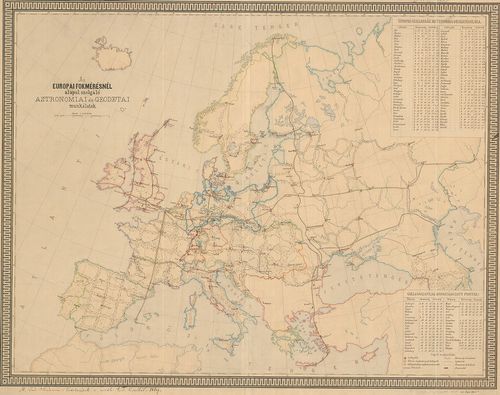
| Title | Az Európai fokmérésnél alapul szolgáló Astronomiai és Geodetai munkálatok. |
340. Európa a XVIII. század végén. [B I c 161]
Institute and Museum of Military History •
B I c
•
B I Európa
•
B I–XV. Európa
| Title | Európa a XVIII. század végén. |
| Main title | Mt.: Népsűrűség az ipari forradalom előtt (a XVIII. század közepén) |
| Subject | Európa ipara, gazdasága, országhatárjelöléssel a XVIII. században. |
341. Európa a XIX. század végén. [B I c 162]
Institute and Museum of Military History •
B I c
•
B I Európa
•
B I–XV. Európa
| Title | Európa a XIX. század végén. |
| Main title | Mt.: Népsűrűség a XIX. század végén. |
| Subject | Európa ipara, gazdasága országhatár jelöléssel a XIX. sz.-ban. |
342. Európa mezőgazdasága. [B I c 163]
Institute and Museum of Military History •
B I c
•
B I Európa
•
B I–XV. Európa
| Title | Európa mezőgazdasága. |
| Main title | 2 mt.: 1.) Európa állattenyésztése. |
| Subject | 2.) Európa mezőgazdaságának fejlettsége. |
343. A Római Birodalom gazdasága és kultúrája. [B I c 164]
Institute and Museum of Military History •
B I c
•
B I Európa
•
B I–XV. Európa
| Title | A Római Birodalom gazdasága és kultúrája. |
| Main title | 2 mt.: 1.) Róma. |
| Subject | 2. Pannónia a II. sz. elején. |
344. Európa a XI. sz. végén. [B I c 165]
Institute and Museum of Military History •
B I c
•
B I Európa
•
B I–XV. Európa
| Title | Európa a XI. sz. végén. |
345. Európa ipara. [B I c 166]
Institute and Museum of Military History •
B I c
•
B I Európa
•
B I–XV. Európa
| Title | Európa ipara. |
| Main title | 2 mt.: 1.) Európa bányászata |
| Subject | 2.) Európa közlekedése |
346. Európa a népvándorlás korában (357–568). [B I c 167]
Institute and Museum of Military History •
B I c
•
B I Európa
•
B I–XV. Európa
| Title | Európa a népvándorlás korában (357–568). |
347. Európa 1000 körül. [B I c 168]
Institute and Museum of Military History •
B I c
•
B I Európa
•
B I–XV. Európa
| Title | Európa 1000 körül. |
348. QTH-Locator-Karte Európa. [B I c 170]
Institute and Museum of Military History •
B I c
•
B I Európa
•
B I–XV. Európa
| Title | QTH-Locator-Karte Európa. |
| Main title | Európa rádiólokátor beosztásának térképe. |
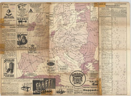
349. Radis – Carte D’Europe. [B I c 171]
Institute and Museum of Military History •
B I c
•
B I Európa
•
B I–XV. Európa
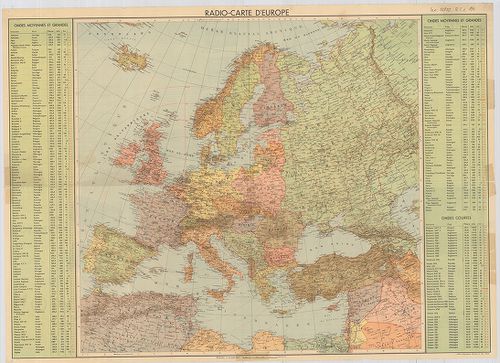
| Title | Radis – Carte D’Europe. |
| Main title | Európa rádió-adóállomásainak hullámhossz, Kilowatt – és távolsági térképe. A Berni rádióadó hatósugarának feltüntetésével. Hátl.: Az Európán kívüli földrészek főbb rádióadóinak hullámhossza, és teljesítménye. Különböző rádiók reklámai (francia nyelven). |
350. Európa 1000 körül. [B I c 172]
Institute and Museum of Military History •
B I c
•
B I Európa
•
B I–XV. Európa
| Title | Európa 1000 körül. |
351. Európa (XII–XIII. sz.) [B I c 173]
Institute and Museum of Military History •
B I c
•
B I Európa
•
B I–XV. Európa
| Title | Európa (XII–XIII. sz.) |
352. Európa (1945–89) [B I c 174]
Institute and Museum of Military History •
B I c
•
B I Európa
•
B I–XV. Európa
| Title | Európa (1945–89) |
| Main title | 1 mt. Berlin (1945–1990) |
353. Az uráli nyelvcsalád földrajzi elhelyezkedése. [B I c 175]
Institute and Museum of Military History •
B I c
•
B I Európa
•
B I–XV. Európa
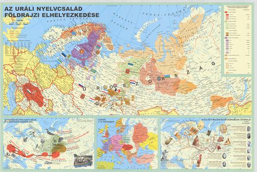
| Title | Az uráli nyelvcsalád földrajzi elhelyezkedése. |
| Main title | 3 melléktérkép: 1. Az őshaza feltételezett helye és a magyarok vándorlása |
| Subject | 2. Európa a 10. században |
354. New Rail Map of Europe. [B I c 176]
Institute and Museum of Military History •
B I c
•
B I Európa
•
B I–XV. Európa
| Title | New Rail Map of Europe. |
355. Europa w okresie wedrówek ludów (375-500) oprakowal Józef Wo... [B I c 177]
Institute and Museum of Military History •
B I c
•
B I Európa
•
B I–XV. Európa
| Title | Europa w okresie wedrówek ludów (375-500) oprakowal Józef Wolski. |
356. Carte des Chemins de Fer de L'Europe. Union Internationale ... [B I c 178]
Institute and Museum of Military History •
B I c
•
B I Európa
•
B I–XV. Európa
| Title | Carte des Chemins de Fer de L'Europe. Union Internationale des Chemins de Fer. |
357. Triolni Boje V 15-18. Stoleti. [B I c 179]
Institute and Museum of Military History •
B I c
•
B I Európa
•
B I–XV. Európa
| Title | Triolni Boje V 15-18. Stoleti. |
358. Europa po Videnském Kongresu (1815-1847). [B I c 180]
Institute and Museum of Military History •
B I c
•
B I Európa
•
B I–XV. Európa
| Title | Europa po Videnském Kongresu (1815-1847). |
359. Humoristische Karte von Europa im Jahre 1914. [B I c 181]
Institute and Museum of Military History •
B I c
•
B I Európa
•
B I–XV. Európa
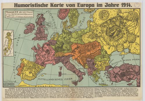
| Title | Humoristische Karte von Europa im Jahre 1914. |
| Main title | Európa karikatúra-térképe 1914-ben. |
360. Európa Térképe. [B I c 182]
Institute and Museum of Military History •
B I c
•
B I Európa
•
B I–XV. Európa
| Title | Európa Térképe. |