51. Ostalpen. [B IX b 64]
Institute and Museum of Military History •
B IX b
•
B IX Ausztria–Magyarország
•
B I–XV. Európa
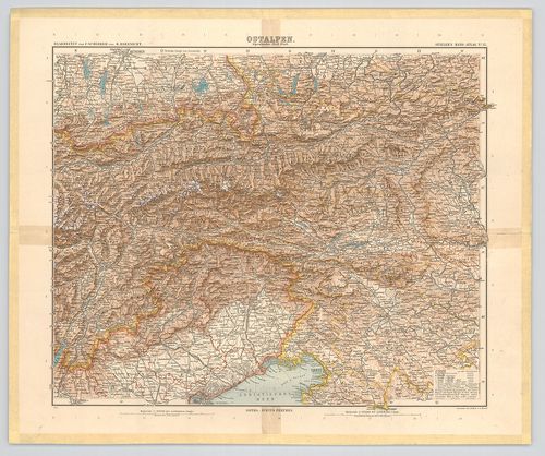
| Title | Ostalpen. |
| Main title | A Keleti-Alpok térképe 1901-ben. |
52. Uebersichts-Karte der Ostalpen, westliches Blatt. [B IX b 65]
Institute and Museum of Military History •
B IX b
•
B IX Ausztria–Magyarország
•
B I–XV. Európa
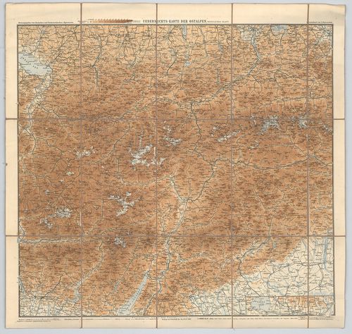
| Title | Uebersichts-Karte der Ostalpen, westliches Blatt. |
| Main title | A Keleti-Alpok nyugati részének áttekintő térképe 1892-ben. |
53. Uebersichts-Karte der Ostalpen, westliches Blatt. (Neue-Ausg... [B IX b 65/1]
Institute and Museum of Military History •
B IX b
•
B IX Ausztria–Magyarország
•
B I–XV. Európa
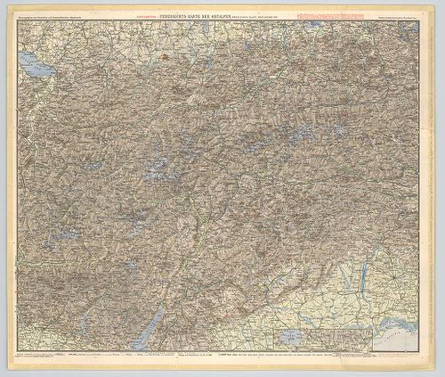
| Title | Uebersichts-Karte der Ostalpen, westliches Blatt. (Neue-Ausgabe 1900) |
| Main title | A Keleti-Alpok nyugati részének áttekintő térképe 1900-ban. |
54. Karte der Adamello – und Presanella – Gruppe. [B IX b 69/1]
Institute and Museum of Military History •
B IX b
•
B IX Ausztria–Magyarország
•
B I–XV. Európa
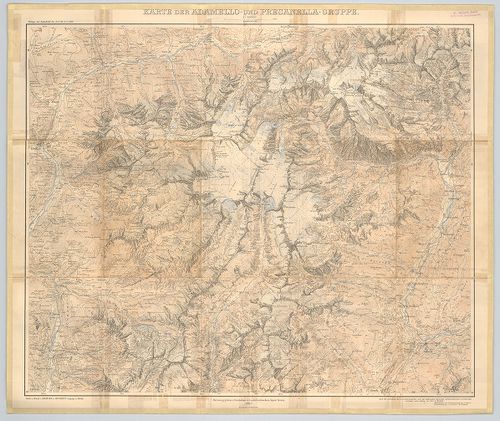
| Title | Karte der Adamello – und Presanella – Gruppe. |
| Main title | Az Adamello és Presanella hegycsoportok (Ol.) térképe 1903-ban. |
55. Karte der Langkofel- und Sellagruppe. [B IX b 70/5]
Institute and Museum of Military History •
B IX b
•
B IX Ausztria–Magyarország
•
B I–XV. Európa
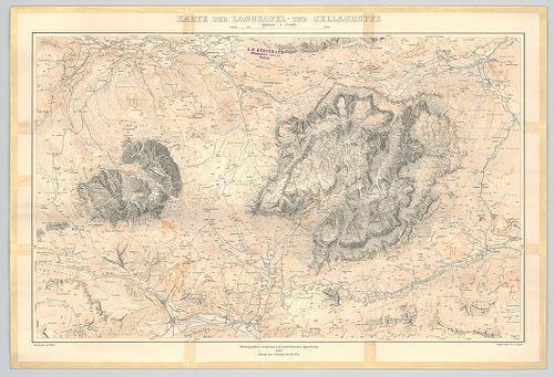
| Title | Karte der Langkofel- und Sellagruppe. |
| Main title | A Langkofel és a Sella hegycsoport (Ol.) térképe 1904-ben. |
56. Panorama vom Rittner-Horn nächst Bozen-Tirol. [B IX b 71]
Institute and Museum of Military History •
B IX b
•
B IX Ausztria–Magyarország
•
B I–XV. Európa
| Title | Panorama vom Rittner-Horn nächst Bozen-Tirol. |
| Main title | A Rittner-Horn hegység (Au.–Ol.) panoráma képe 1920 körül. |
57. Das Semmeringgebiet mit Rax und Schneeberg. [B IX b 72/2]
Institute and Museum of Military History •
B IX b
•
B IX Ausztria–Magyarország
•
B I–XV. Európa
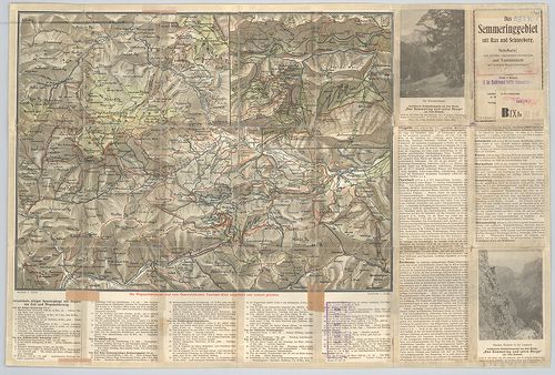
| Title | Das Semmeringgebiet mit Rax und Schneeberg. |
| Main title | Hátlapon: [A Semmering és a Schneeberg hegységek turistaútjai.] |
| Subject | Mt. [A Semmering turistaútjai.] |
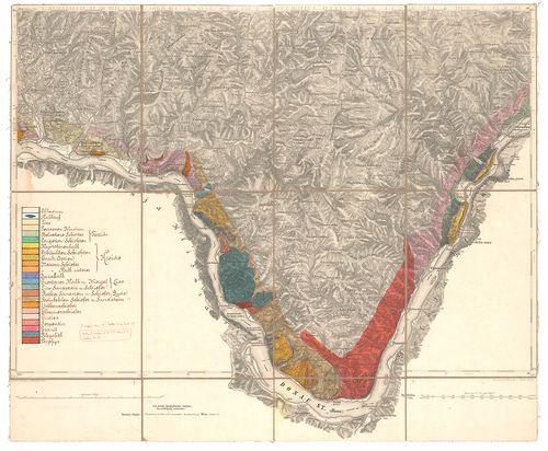
58. Übersichtskarte der Dolomiten. [B IX b 72/7]
Institute and Museum of Military History •
B IX b
•
B IX Ausztria–Magyarország
•
B I–XV. Európa
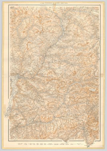
| Title | Übersichtskarte der Dolomiten. |
| Main title | A Dolomitok hegyrajzi áttekintő térképe 1903-ban. |
59. Karte des Riesen-Gebirgs. [B IX b 77]
Institute and Museum of Military History •
B IX b
•
B IX Ausztria–Magyarország
•
B I–XV. Európa
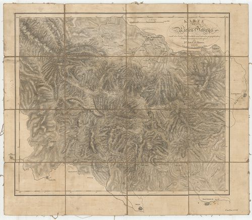
| Title | Karte des Riesen-Gebirgs. |
| Main title | A Karkonosze (Riesen-Gebirgs) hegység térképe 1806-ban. |
60. Situation und Längenprofil der dammherstellung im Laibacher ... [B IX b 78]
Institute and Museum of Military History •
B IX b
•
B IX Ausztria–Magyarország
•
B I–XV. Európa
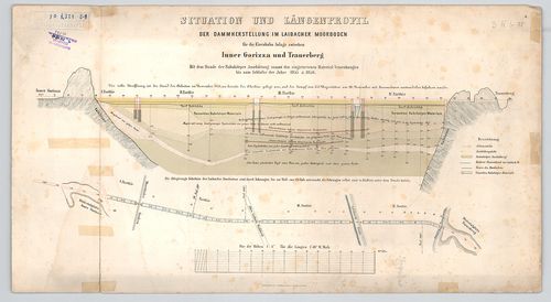
| Title | Situation und Längenprofil der dammherstellung im Laibacher Moorboden. |
| Main title | A ljubljanai lápos talaj gáthelyreállítási helyzetképe és hosszanti keresztmetszete 1855–1856-ban. (Vasútépítési munkálatokhoz.) |
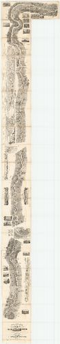
61. Karte der Ost-Alpen. [B IX b 79]
Institute and Museum of Military History •
B IX b
•
B IX Ausztria–Magyarország
•
B I–XV. Európa
| Title | Karte der Ost-Alpen. |
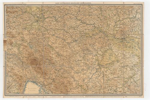
| Main title | Blatt: 1. Karte der Bayerischen u. Algäuer-Alpen. 2. Karte der Salzburger Alpen u. des Salzkammergutes. 3. Karte des Oesterreichischen Alpen u. des Winer-Waldes. 4. Karte der West-Tiroler u. Engadiner-Alpen. 5. Karte der Ost-Tiroler Alpen, Tauern- u. Dolomiten. 6. Karte der Steierischen Alpen u. der Karawanken. 7. Karte der Lombardischen u. Süd-Tiroler Alpen. 8. Karte der Südvenetianischen Alpen u. Karst. 9. Karte des Krainisch-Kroatischen Gebirgs Landes. |
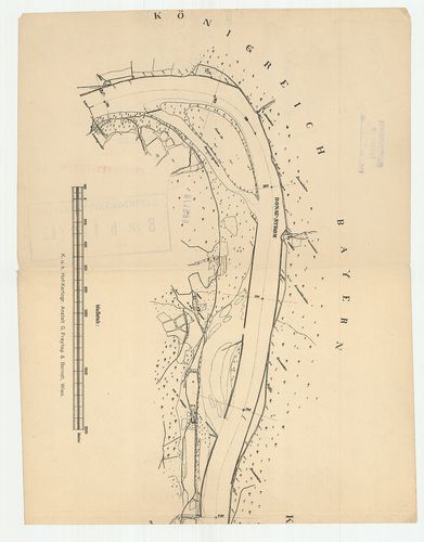
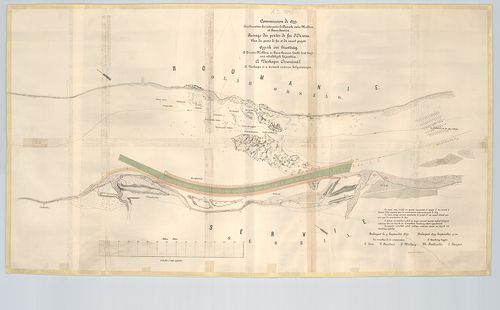
| Subject | Az Alpok keleti részének hipszometrikus térképe 1880–1893-ban. |
62. Karte Boszne i Hercegovine. [B IX b 80/1]
Institute and Museum of Military History •
B IX b
•
B IX Ausztria–Magyarország
•
B I–XV. Európa
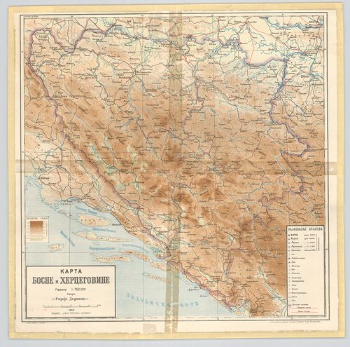
| Title | Karte Boszne i Hercegovine. |
| Main title | Bosznia és Hercegovina hegyvízrajzi térképe 1909-ben. |
63. Hydrographische Karte der oestereichischen Erbstaaten diesse... [B IX b 81]
Institute and Museum of Military History •
B IX b
•
B IX Ausztria–Magyarország
•
B I–XV. Európa
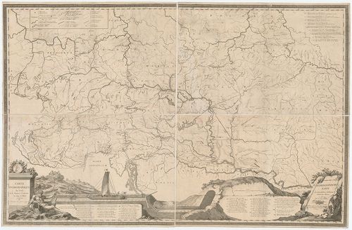
| Title | Hydrographische Karte der oestereichischen Erbstaaten diesseits des Rheins. – Carte hydrographique des Etats de la Maison d’Autriche en deca du Rhin. |
| Main title | Csatornatervek. I. Jonction de la mer Adriatique á la Culpa-Verbindung des Adriatischen Meeres mit der Kulpa. (Az Adriai-tenger összeköttetése a Kulpa folyóval.) |
| Subject | II. Jonction de la Drave a la Save-Verbindung der Drau mit der Sau. (A Dráva és Száva összeköttetése.) |
64. Hydrographische Uibersichtskarte der Flüsse, Bäche und sonst... [B IX b 83]
Institute and Museum of Military History •
B IX b
•
B IX Ausztria–Magyarország
•
B I–XV. Európa
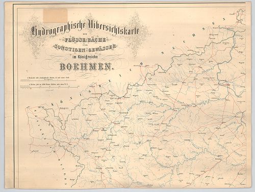
| Title | Hydrographische Uibersichtskarte der Flüsse, Bäche und sonstigen gewässer im Königreiche Boehmen. |
| Main title | Csehország áttekintő vízrajzi térképe. |
65. A verseczi hegység magassági rétegeinek térképe. [B IX b 85]
Institute and Museum of Military History •
B IX b
•
B IX Ausztria–Magyarország
•
B I–XV. Európa
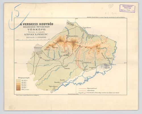
| Title | A verseczi hegység magassági rétegeinek térképe. |
66. A Gömör megyei Hradek és környékének geológiai térképe. [B IX b 87]
Institute and Museum of Military History •
B IX b
•
B IX Ausztria–Magyarország
•
B I–XV. Európa
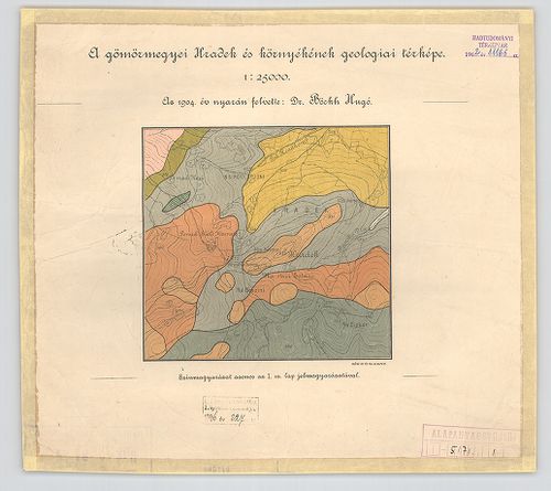
| Title | A Gömör megyei Hradek és környékének geológiai térképe. |
67. Karte der Slawonischen Drau Donak Ebene mit dem Canalisation... [B IX b 91]
Institute and Museum of Military History •
B IX b
•
B IX Ausztria–Magyarország
•
B I–XV. Európa
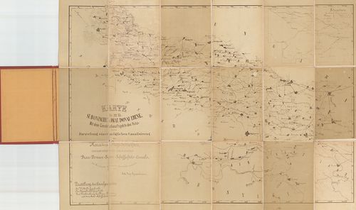
| Title | Karte der Slawonischen Drau Donak Ebene mit dem Canalisations Projekte des Vuka- und der Darstellung einer möglichen Canalisirung des Karasica-Fluss Gebiethes. |
| Main title | Mt.: Situation der Canal Projecte. (A csatornatervezet helyzete.) |
| Subject | A szlavóniai Dráva térképe a 19. században, csatornázási tervek. |
68. [A Duna vízgyűjtője a német-osztrák határtól a torkolatig. M... [B IX b 93]
Institute and Museum of Military History •
B IX b
•
B IX Ausztria–Magyarország
•
B I–XV. Európa
| Title | [A Duna vízgyűjtője a német-osztrák határtól a torkolatig. Magassági pontok, egyéb megírás nélkül.] |
69. Carta idrografica del golfo di Trieste. … [B IX b 94]
Institute and Museum of Military History •
B IX b
•
B IX Ausztria–Magyarország
•
B I–XV. Európa
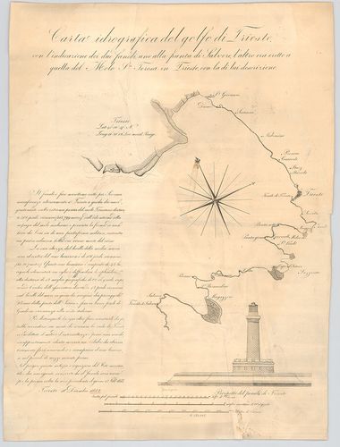
| Title | Carta idrografica del golfo di Trieste. … |
| Main title | A Trieszti-öböl vízrajzi térképe 1832 körül. |
70. Piano della rada di Trieste. [B IX b 94/1]
Institute and Museum of Military History •
B IX b
•
B IX Ausztria–Magyarország
•
B I–XV. Európa
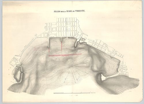
| Title | Piano della rada di Trieste. |
| Main title | Az új trieszti kikötő tervrajza 1867 körül. |
71. Golf von Fiume. [B IX b 95]
Institute and Museum of Military History •
B IX b
•
B IX Ausztria–Magyarország
•
B I–XV. Európa
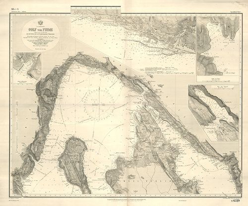
| Title | Golf von Fiume. |
| Main title | 4 mt. 1 Hafen von Martinšćica. (Martinšćici-öböl.) 2. Hafen von Fiume. (Fiumei-öböl.) 3. Hafen von Rabaz. (Rabazi-öböl.) 4. Bai von Buccari. (Buccari-öböl.) |
| Subject | A Fiumei-öböl térképe az 1867-es állapotoknak megfelelően. |
72. Adriatisches Meer general- und Kurskarte. [B IX b 95/1]
Institute and Museum of Military History •
B IX b
•
B IX Ausztria–Magyarország
•
B I–XV. Európa
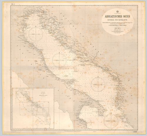
| Title | Adriatisches Meer general- und Kurskarte. |
| Main title | Mt. Einteilung der Karten des Adriatischen Meeres. (Az Adriai-tenger térképeinek szelvényezése.) |
| Subject | Az Adriai-tenger útvonalainak általános térképe az 1873. évi állapotok szerint. |
73. Mündung der Bocche di Cattaro. [B IX b 103]
Institute and Museum of Military History •
B IX b
•
B IX Ausztria–Magyarország
•
B I–XV. Európa
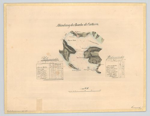
| Title | Mündung der Bocche di Cattaro. |
| Main title | A Kotori-öböl 1860 körül. |
74. Cursus Danubii abui Pala[n]ka usque vetislan, et Severinum. [B IX b 107]
Institute and Museum of Military History •
B IX b
•
B IX Ausztria–Magyarország
•
B I–XV. Európa
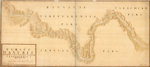
| Title | Cursus Danubii abui Pala[n]ka usque vetislan, et Severinum. |
| Main title | Az Al-Duna Palánkától Turnu Severinig. |
75. Die Tonau von Wienn bis auff Griegises Weissenburg. [B IX b 107/1]
Institute and Museum of Military History •
B IX b
•
B IX Ausztria–Magyarország
•
B I–XV. Európa
| Title | Die Tonau von Wienn bis auff Griegises Weissenburg. |
| Main title | A Duna Bécstől Belgrádig a 16. században. |
76. Karte des Canals welcher in drey Hauptabtheilungan, A.) von ... [B IX b 108]
Institute and Museum of Military History •
B IX b
•
B IX Ausztria–Magyarország
•
B I–XV. Európa
| Title | Karte des Canals welcher in drey Hauptabtheilungan, A.) von Wien bis an die Leitha bey Neustadt, B.) von der Leitha bis Oedenburg, C.) von Oedenburg bis Raab unter dem unmittelbaren Schutze. |
| Main title | A Bécs–Sopron–Győri csatornatervezet térképe 1820 körül. |
77. Plan des Donau-Stroms zwischen Bellegrat und Orsova Worauf d... [B IX b 109]
Institute and Museum of Military History •
B IX b
•
B IX Ausztria–Magyarország
•
B I–XV. Európa
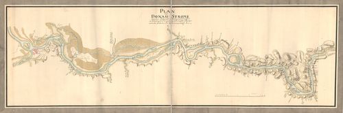
| Title | Plan des Donau-Stroms zwischen Bellegrat und Orsova Worauf die an Selbe Liegende dermaliche Wehrhaffte Vestungen auch alle Schlöscher und Rudera angemerket Sein. |
| Main title | A Duna Belgrád és Orsova közötti szakasza várak és erődök feltüntetésével 1737 körül. |
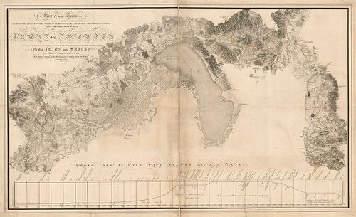
78. A Duna és mellékfolyóinak ártere Alsó-Magyarországban. – Ter... [B IX b 110]
Institute and Museum of Military History •
B IX b
•
B IX Ausztria–Magyarország
•
B I–XV. Európa
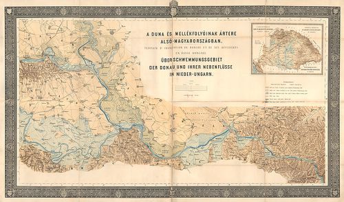
| Title | A Duna és mellékfolyóinak ártere Alsó-Magyarországban. – Terrain d’inondation du Danube et de ses affluents en basse Hongrie. – Ueber-schwemmungsgebiet der Donau und ihrer nebenflüsse in Nieder-Ungarn. |
| Main title | Mt. A magyarországi Duna és mellékfolyói árterének átnézeti térképe. – Terrain d’inondation du Danube et de ses affluents en Hongrie. – Überschwemmungsgebiet der Donau und deren nebenflüsse in Ungarn. |
79. [A Duna Bécs és Giorgio közti szakaszának térképe.] [B IX b 112]
Institute and Museum of Military History •
B IX b
•
B IX Ausztria–Magyarország
•
B I–XV. Európa
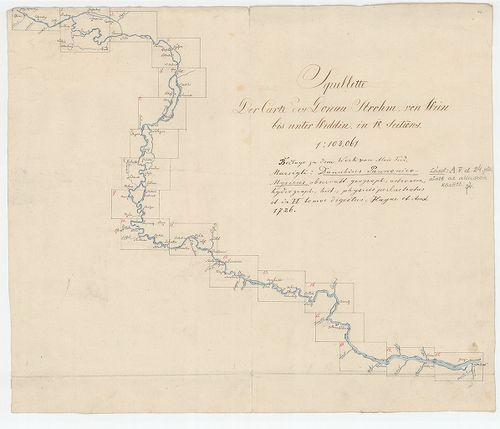
| Title | [A Duna Bécs és Giorgio közti szakaszának térképe.] |
80. Plan von dem Laufe des Donau Stroms von Ofen bis Baja. [B IX b 115]
Institute and Museum of Military History •
B IX b
•
B IX Ausztria–Magyarország
•
B I–XV. Európa
| Title | Plan von dem Laufe des Donau Stroms von Ofen bis Baja. |
| Main title | A Duna Buda és Baja között 1740 körül. |
81. A’ Ferencz csatorna Pestig hosszabbításának eszméje. [B IX b 115/2]
Institute and Museum of Military History •
B IX b
•
B IX Ausztria–Magyarország
•
B I–XV. Európa

| Title | A’ Ferencz csatorna Pestig hosszabbításának eszméje. |
82. Die Donau vom Ursprung bis Ulm. Der schiffbare Donau-Strom v... [B IX b 116]
Institute and Museum of Military History •
B IX b
•
B IX Ausztria–Magyarország
•
B I–XV. Európa

| Title | Die Donau vom Ursprung bis Ulm. Der schiffbare Donau-Strom von Ulm bis Pressburg. |
| Main title | A Duna eredetétől Ulmig, valamint a hajózható szakasz Ulmtól Pozsonyig. |
83. Karte der Donau von ihrem Ursprunge bis an die Mündung. [B IX b 117]
Institute and Museum of Military History •
B IX b
•
B IX Ausztria–Magyarország
•
B I–XV. Európa
| Title | Karte der Donau von ihrem Ursprunge bis an die Mündung. |
| Main title | A Duna térképe eredetétől a torkolatig 1850 körül. |
84. Carte du cours du Danube depuis Ulm jusqua son embouchure da... [B IX b 118]
Institute and Museum of Military History •
B IX b
•
B IX Ausztria–Magyarország
•
B I–XV. Európa
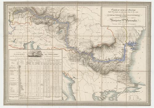
| Title | Carte du cours du Danube depuis Ulm jusqua son embouchure dans la Mer noire ou guide de voyage a Constantinople… |
| Main title | A Duna Ulmtól a Fekete-tengerig 1839 körül a folyómenti települések feltüntetésével. |
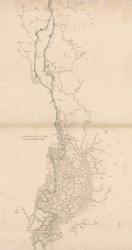
85. A Duna Orsova-Szulina-i szakasza. [B IX b 119]
Institute and Museum of Military History •
B IX b
•
B IX Ausztria–Magyarország
•
B I–XV. Európa
| Title | A Duna Orsova-Szulina-i szakasza. |
86. Panorama der Donau von Linz bis Wien. [B IX b 120]
Institute and Museum of Military History •
B IX b
•
B IX Ausztria–Magyarország
•
B I–XV. Európa
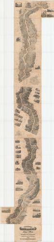
| Title | Panorama der Donau von Linz bis Wien. |
| Main title | A Duna madártávlati képe Linz és Bécs között 1839-ben. |
87. Panorama der Donau von Regensburg bis Linz in Vogelperspecti... [B IX b 121]
Institute and Museum of Military History •
B IX b
•
B IX Ausztria–Magyarország
•
B I–XV. Európa
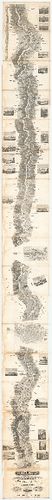
| Title | Panorama der Donau von Regensburg bis Linz in Vogelperspective. |
| Main title | A Duna madártávlati képe Regensburg és Linz között 1840-ben. |
88. Panorama der Donau von Wien bis Pesth. [B IX b 122]
Institute and Museum of Military History •
B IX b
•
B IX Ausztria–Magyarország
•
B I–XV. Európa
| Title | Panorama der Donau von Wien bis Pesth. |
| Main title | A Duna madártávlati képe Bécs és Pest között 1842-ben. |
89. A Duna Ulmtól a torkolatig. – Die Donau von Ulm bis zur Münd... [B IX b 122/1]
Institute and Museum of Military History •
B IX b
•
B IX Ausztria–Magyarország
•
B I–XV. Európa
| Title | A Duna Ulmtól a torkolatig. – Die Donau von Ulm bis zur Mündung átnézeti térképe |
90. Topographisch hydrometrischen Donau Strom Karte von Petronel... [B IX b 122/2]
Institute and Museum of Military History •
B IX b
•
B IX Ausztria–Magyarország
•
B I–XV. Európa
| Title | Topographisch hydrometrischen Donau Strom Karte von Petronell… |
| Main title | A Duna topográfiai térképe Petronelltől (Alsó-Ausztria) Csernetzig (Vaskapu-szoros). |
91. [Topographisch hydrometrischen Donau Strom Karte von Petrone... [B IX b 122/3]
Institute and Museum of Military History •
B IX b
•
B IX Ausztria–Magyarország
•
B I–XV. Európa
| Title | [Topographisch hydrometrischen Donau Strom Karte von Petronell… |
| Main title | A Duna topográfiai térképe 1890 körül. |
92. Die Donau von ihrem Ursprung bis an die Mündung. Eine Schild... [B IX b 122/8]
Institute and Museum of Military History •
B IX b
•
B IX Ausztria–Magyarország
•
B I–XV. Európa
| Title | Die Donau von ihrem Ursprung bis an die Mündung. Eine Schilderung von Land und Leuten des Donaugebietes. |
| Main title | A Duna eredetétől a torkolatig, valamint a Duna menti népek és vidékek leírása 1881-ben. |
93. Karte der Donau von ihrem Ursprunge bis an die Mündung. [B IX b 122/10]
Institute and Museum of Military History •
B IX b
•
B IX Ausztria–Magyarország
•
B I–XV. Európa
| Title | Karte der Donau von ihrem Ursprunge bis an die Mündung. |
| Main title | A Duna térképe eredetétől a torkolatig 1900 körül. |
94. Duna helyszínrajz Schlägen-Linz és Linz-Ybbs között. [B IX b 122/11]
Institute and Museum of Military History •
B IX b
•
B IX Ausztria–Magyarország
•
B I–XV. Európa
| Title | Duna helyszínrajz Schlägen-Linz és Linz-Ybbs között. |
95. [A Duna térképe Lindentől-Kaltenbachig.] [B IX b 122/12]
Institute and Museum of Military History •
B IX b
•
B IX Ausztria–Magyarország
•
B I–XV. Európa
| Title | [A Duna térképe Lindentől-Kaltenbachig.] |
96. Preliminaire Donau Karte. [B IX b 123]
Institute and Museum of Military History •
B IX b
•
B IX Ausztria–Magyarország
•
B I–XV. Európa
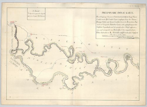
| Title | Preliminaire Donau Karte. |
| Main title | A Duna térképe Bajától Péterváradig 1788 szeptemberben. |
97. A Soroksári Dunaág helyszínrajza a Tassi zsiliptől a Gubacsi... [B IX b 124]
Institute and Museum of Military History •
B IX b
•
B IX Ausztria–Magyarország
•
B I–XV. Európa
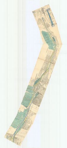
| Title | A Soroksári Dunaág helyszínrajza a Tassi zsiliptől a Gubacsi hídig. |
98. [A Kazán-szoros és környékének szintvonalas kéziratos térkép... [B IX b 125]
Institute and Museum of Military History •
B IX b
•
B IX Ausztria–Magyarország
•
B I–XV. Európa
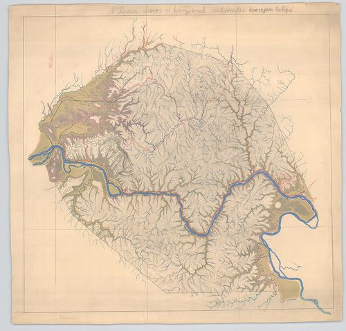
| Title | [A Kazán-szoros és környékének szintvonalas kéziratos térképe. |
99. Berzaszka und Ó-Ogradina. [B IX b 125/1]
Institute and Museum of Military History •
B IX b
•
B IX Ausztria–Magyarország
•
B I–XV. Európa
| Title | Berzaszka und Ó-Ogradina. |
| Main title | Az Al-Duna partvidékének 1:75 000 ma. alaptérképére (6168 sz.) rajzolt geológiai térképe Berzaszka (Berzasca) és Ó-Ogradina (Ogradena-Veche) között. |
100. [Vaskapu] 1879-ik évi bizottság. A Dunán Moldova és Turn[u]-... [B IX b 125/2]
Institute and Museum of Military History •
B IX b
•
B IX Ausztria–Magyarország
•
B I–XV. Európa
| Title | [Vaskapu] 1879-ik évi bizottság. A Dunán Moldova és Turn[u]-Severin között levő hajózási akadályok kijavítása. A Vaskapu Orsovánál. A Vaskapu és a tervezett csatorna helyszínrajza. – Commission de 1879. Amélioration des cataractes du Danube entre Moldova et Turn[u]-Severin. Panoge des portes de fer et du canal projeté. |