251. Nagy-Bánya vidéke. – Umgebung von Nagy-Bánya. 15. Zóna XXIX.... [B IX b 383]
Institute and Museum of Military History •
B IX b
•
B IX Ausztria–Magyarország
•
B I–XV. Európa
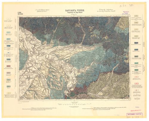
| Title | Nagy-Bánya vidéke. – Umgebung von Nagy-Bánya. 15. Zóna XXIX. Rovat (4971-es szelvény). Geológiai térkép. |
252. Nagyszombat vidéke. 12. Zóna XVII. Rovat (4659-es szelvény). [B IX b 384]
Institute and Museum of Military History •
B IX b
•
B IX Ausztria–Magyarország
•
B I–XV. Európa
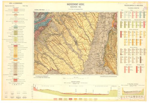
| Title | Nagyszombat vidéke. 12. Zóna XVII. Rovat (4659-es szelvény). |
| Main title | Geológiai térkép. |
253. Nagyvárad. 17. Zóna XVI. Rovat. Geológiai térkép. (5158-as ... [B IX b 385]
Institute and Museum of Military History •
B IX b
•
B IX Ausztria–Magyarország
•
B I–XV. Európa
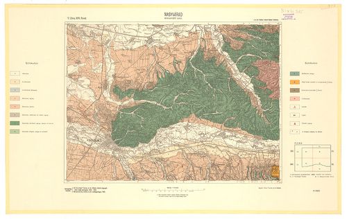
| Title | Nagyvárad. 17. Zóna XVI. Rovat. Geológiai térkép. (5158-as szelvény). |
254. Ökrös. 19. Zóna XXVI. Rovat (5368-as szelvény). Geológiai té... [B IX b 386]
Institute and Museum of Military History •
B IX b
•
B IX Ausztria–Magyarország
•
B I–XV. Európa
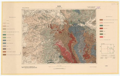
| Title | Ökrös. 19. Zóna XXVI. Rovat (5368-as szelvény). Geológiai térkép. |
255. Ökörmező és Tuchla. 10, 11, öv. XXIX. 4471, 4571. oszlop. [B IX b 387]
Institute and Museum of Military History •
B IX b
•
B IX Ausztria–Magyarország
•
B I–XV. Európa
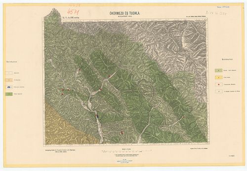
| Title | Ökörmező és Tuchla. 10, 11, öv. XXIX. 4471, 4571. oszlop. |
| Main title | Geológiai térkép. |
256. Petrozsény vidéke. Zone 24. col. XXIX. (5871-es szelvény.) G... [B IX b 388]
Institute and Museum of Military History •
B IX b
•
B IX Ausztria–Magyarország
•
B I–XV. Európa
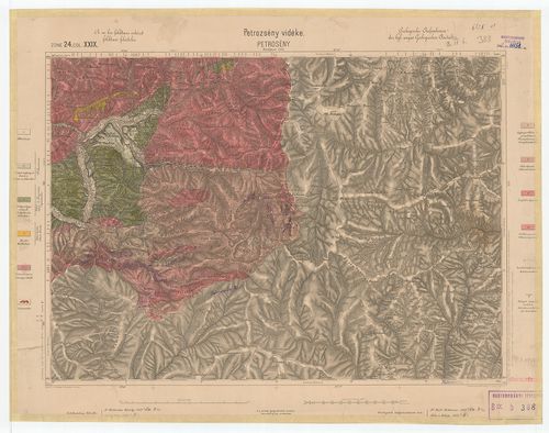
| Title | Petrozsény vidéke. Zone 24. col. XXIX. (5871-es szelvény.) Geológiai térkép. |
257. Resicabánya és Karánsebes. 24. Zóna XXVI. Rovat (5868-as sze... [B IX b 389]
Institute and Museum of Military History •
B IX b
•
B IX Ausztria–Magyarország
•
B I–XV. Európa
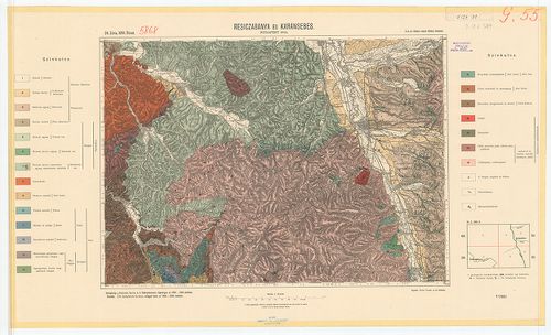
| Title | Resicabánya és Karánsebes. 24. Zóna XXVI. Rovat (5868-as szelvény). Geológiai térkép. |
258. Szászsebes. 22. Zóna XXIX. Rovat (5671-es szelvény). [B IX b 390]
Institute and Museum of Military History •
B IX b
•
B IX Ausztria–Magyarország
•
B I–XV. Európa

| Title | Szászsebes. 22. Zóna XXIX. Rovat (5671-es szelvény). |
| Main title | Geológiai térkép. |
259. Szempcz és Tallós vidéke. 13. Zóna XVII. Rovat (4759-es szel... [B IX b 391]
Institute and Museum of Military History •
B IX b
•
B IX Ausztria–Magyarország
•
B I–XV. Európa
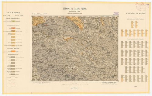
| Title | Szempcz és Tallós vidéke. 13. Zóna XVII. Rovat (4759-es szelvény). |
| Main title | Geológiai térkép. |
260. Temeskutas és Oraviczabánya. 25. Zóna XXV. Rovat (5967-es sz... [B IX b 392]
Institute and Museum of Military History •
B IX b
•
B IX Ausztria–Magyarország
•
B I–XV. Európa
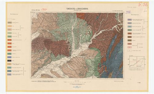
| Title | Temeskutas és Oraviczabánya. 25. Zóna XXV. Rovat (5967-es szelvény). |
| Main title | Geológiai térkép. |
261. Vágsellye és Nagysurány vidéke. 13. Zóna XVIII. Rovat (4760-... [B IX b 393]
Institute and Museum of Military History •
B IX b
•
B IX Ausztria–Magyarország
•
B I–XV. Európa

| Title | Vágsellye és Nagysurány vidéke. 13. Zóna XVIII. Rovat (4760-as szelvény). |
| Main title | Geológiai térkép. |
262. Nagy-Vázsony vidéke. – Umgebungen von Nagy Vázsony. Geológia... [B IX b 394]
Institute and Museum of Military History •
B IX b
•
B IX Ausztria–Magyarország
•
B I–XV. Európa
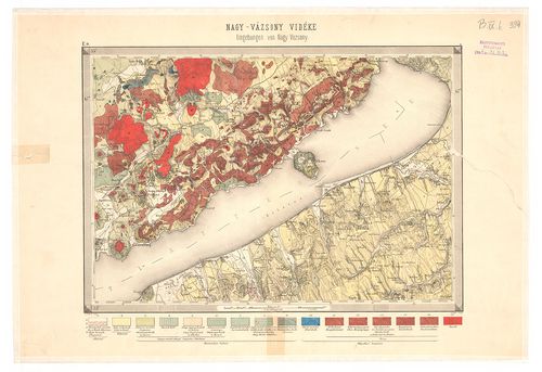
| Title | Nagy-Vázsony vidéke. – Umgebungen von Nagy Vázsony. Geológiai térkép. |
263. Puszta Sz.[ent] Lőrincz vidékének földtani talajtérképe. Ráh... [B IX b 395]
Institute and Museum of Military History •
B IX b
•
B IX Ausztria–Magyarország
•
B I–XV. Európa
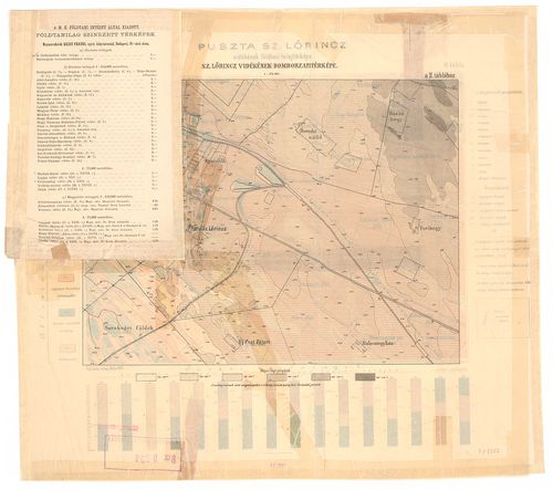
| Title | Puszta Sz.[ent] Lőrincz vidékének földtani talajtérképe. Ráhelyezett oleátán Szentlőrinc vidékének domborzati térképe, hipsz., magassági adatok. |
| Main title | Geológiai térkép. |
264. Az Aranyidai keleti bányamező. – Das oestliche Bergrevier vo... [B IX b 396]
Institute and Museum of Military History •
B IX b
•
B IX Ausztria–Magyarország
•
B I–XV. Európa
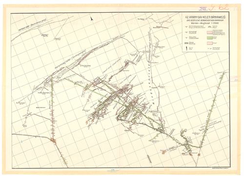
| Title | Az Aranyidai keleti bányamező. – Das oestliche Bergrevier von Aranyida. |
265. Aranyida környékének földtani térképe. – Geologsiche Karte d... [B IX b 397]
Institute and Museum of Military History •
B IX b
•
B IX Ausztria–Magyarország
•
B I–XV. Európa
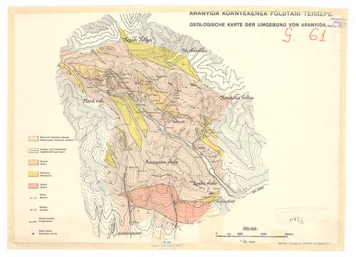
| Title | Aranyida környékének földtani térképe. – Geologsiche Karte der Umgebung von Aranyida. |
266. A Baradla, az Aggteleki cseppkőbarlang alaprajza. [B IX b 398]
Institute and Museum of Military History •
B IX b
•
B IX Ausztria–Magyarország
•
B I–XV. Európa
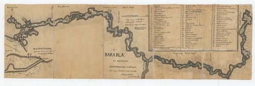
| Title | A Baradla, az Aggteleki cseppkőbarlang alaprajza. |
267. Plan von Tappe ober Szegedin bis zur Donau bei Slankamen. [B IX b 399]
Institute and Museum of Military History •
B IX b
•
B IX Ausztria–Magyarország
•
B I–XV. Európa
| Title | Plan von Tappe ober Szegedin bis zur Donau bei Slankamen. |
| Main title | 2 mt.: 1. Plan von der Festung Segedin. (A szegedi erődítmény kétféle alaprajza.) 2. A Tisza Tápétól Szegeden át a Dunáig Slankamenig. |
268. Carte géologique de la Hongrie et de la Trynsylvanie ... [B IX b 400]
Institute and Museum of Military History •
B IX b
•
B IX Ausztria–Magyarország
•
B I–XV. Európa
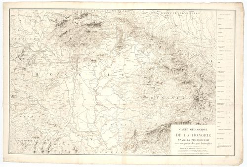
| Title | Carte géologique de la Hongrie et de la Trynsylvanie ... |
| Main title | Magyarország és Erdély geológiai térképe. |
269. A la vui Aufnahme der Donau von Presburg bis Komorn. [B IX b 401]
Institute and Museum of Military History •
B IX b
•
B IX Ausztria–Magyarország
•
B I–XV. Európa
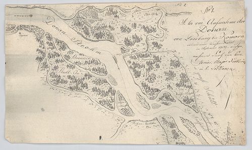
| Title | A la vui Aufnahme der Donau von Presburg bis Komorn. |
| Main title | A Duna Pozsony és Komárom között. |
270. A la vui Aufnahme des Blatten-See. [B IX b 402]
Institute and Museum of Military History •
B IX b
•
B IX Ausztria–Magyarország
•
B I–XV. Európa
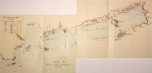
| Title | A la vui Aufnahme des Blatten-See. |
| Main title | A Balaton „a la vue” felmérési térképe 1809-ből. |
271. Plan der Donau Strecke von Semlin bis zu der Passage Eiserne... [B IX b 403]
Institute and Museum of Military History •
B IX b
•
B IX Ausztria–Magyarország
•
B I–XV. Európa
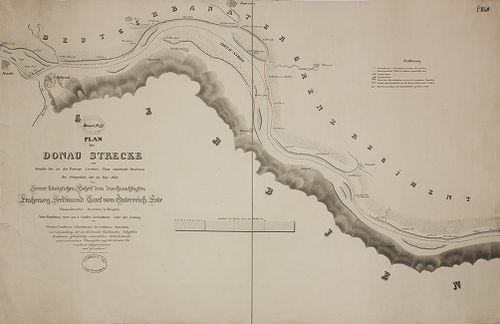
| Title | Plan der Donau Strecke von Semlin bis zu der Passage Eisernes Thor unterhalb Orschowa... |
| Main title | A Duna Zemlintől Orsováig a Vaskapu-szoroson át. |
272. Plan der Donau Passage Kazan oberhalb der veteranischen Höhl... [B IX b 404]
Institute and Museum of Military History •
B IX b
•
B IX Ausztria–Magyarország
•
B I–XV. Európa
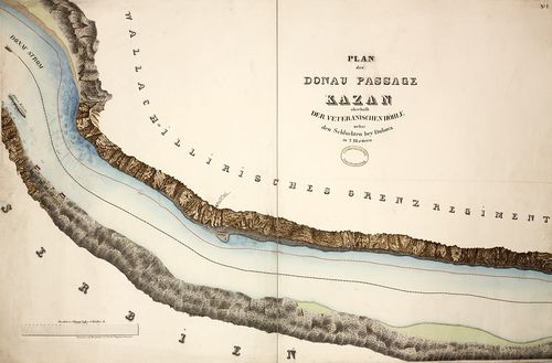
| Title | Plan der Donau Passage Kazan oberhalb der veteranischen Höhle nebst den Schluchten bey Dubova... |
| Main title | A Duna a Kazán-szorosnál. |
273. Plan der Donau Passage Babakay unterhalb Moldawa... [B IX b 405]
Institute and Museum of Military History •
B IX b
•
B IX Ausztria–Magyarország
•
B I–XV. Európa
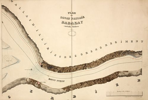
| Title | Plan der Donau Passage Babakay unterhalb Moldawa... |
| Main title | A Duna a Babakay -szorosnál. |
274. Plan der Donau Passage Izlaz oberhalb Swinitza... [B IX b 406]
Institute and Museum of Military History •
B IX b
•
B IX Ausztria–Magyarország
•
B I–XV. Európa
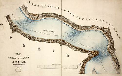
| Title | Plan der Donau Passage Izlaz oberhalb Swinitza... |
| Main title | A Duna az Izlaz-i-szorosnál. |
275. Plan der Donau Passage Eisernes Thor unterhalb Orschowa... [B IX b 407]
Institute and Museum of Military History •
B IX b
•
B IX Ausztria–Magyarország
•
B I–XV. Európa
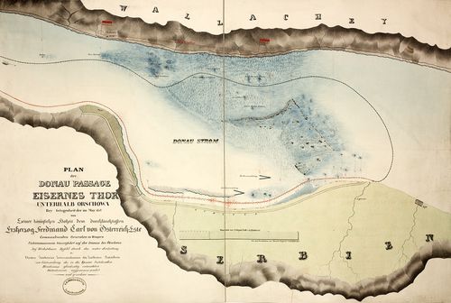
| Title | Plan der Donau Passage Eisernes Thor unterhalb Orschowa... |
| Main title | A Duna a Vaskapu-szorosnál. |
276. Magyarország domborzata és vizei [B IX b 409]
Institute and Museum of Military History •
B IX b
•
B IX Ausztria–Magyarország
•
B I–XV. Európa
| Title | Magyarország domborzata és vizei |
| Main title | 2 melléktk.: 1. Kárpát-medence. |
| Subject | 2. Magyarország közigazgatása. |
277. A Magyar Korona országainak hegy- és vízrajzi térképe. [B IX b 410]
Institute and Museum of Military History •
B IX b
•
B IX Ausztria–Magyarország
•
B I–XV. Európa
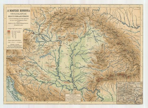
| Title | A Magyar Korona országainak hegy- és vízrajzi térképe. |
| Main title | 1 mt. A Magas-Tátra. |
278. Plann eines theiles des Donau Stromes, beiderseitigen Ufern ... [B IX b 411]
Institute and Museum of Military History •
B IX b
•
B IX Ausztria–Magyarország
•
B I–XV. Európa
| Title | Plann eines theiles des Donau Stromes, beiderseitigen Ufern und zwischen liegenden Insuln, oberhalb der k. k. Fudaker (Futtak) Feld-Proviant Magazin bis Peterwardein. |
| Main title | A Duna egyes részeinek térképe mindkét partján, a szigetekkel együtt, Futtak és Pétervárad között. |
279. Carte géologique des bords du Lac Balaton [B IX b 413]
Institute and Museum of Military History •
B IX b
•
B IX Ausztria–Magyarország
•
B I–XV. Európa
| Title | Carte géologique des bords du Lac Balaton |
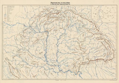
280. Magyarország hegy- és vízrajzi térképe. [B IX b 414]
Institute and Museum of Military History •
B IX b
•
B IX Ausztria–Magyarország
•
B I–XV. Európa
| Title | Magyarország hegy- és vízrajzi térképe. |
281. Geometrische Aufnahme...Maros-Flusses... [B IX b 415]
Institute and Museum of Military History •
B IX b
•
B IX Ausztria–Magyarország
•
B I–XV. Európa
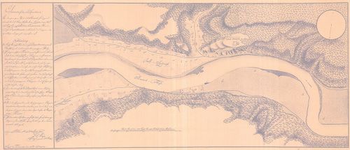
| Title | Geometrische Aufnahme...Maros-Flusses... |
| Main title | A Maros folyó részletes térképe Solymos falu környékén. |
282. Magyarország hegyrajzi és vízrajzi térképe. (2013-as naptár)... [B IX b 417]
Institute and Museum of Military History •
B IX b
•
B IX Ausztria–Magyarország
•
B I–XV. Európa
| Title | Magyarország hegyrajzi és vízrajzi térképe. (2013-as naptár) Dombortérkép. |