421. A Királymezői m. Kir. erdőgondnokság A és B gazdasági osztál... [B IX c 956]
Institute and Museum of Military History •
B IX c
•
B IX Ausztria–Magyarország
•
B I–XV. Európa
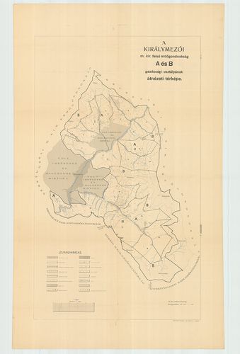
| Title | A Királymezői m. Kir. erdőgondnokság A és B gazdasági osztályának átnézeti térképe. |
422. A Németmokrai m. Kir. erdőgondnokság „A”„B”és „C” gazdasági ... [B IX c 957]
Institute and Museum of Military History •
B IX c
•
B IX Ausztria–Magyarország
•
B I–XV. Európa
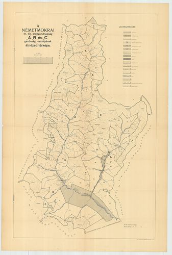
| Title | A Németmokrai m. Kir. erdőgondnokság „A”„B”és „C” gazdasági osztályának átnézeti térképe. |
423. A Técsői m. Kir. erdőgondnokság „A” gazdasági osztályának át... [B IX c 958]
Institute and Museum of Military History •
B IX c
•
B IX Ausztria–Magyarország
•
B I–XV. Európa
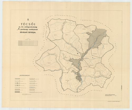
| Title | A Técsői m. Kir. erdőgondnokság „A” gazdasági osztályának átnézeti térképe. |
424. A Técsői m. Kir. erdőgondnokság „B”és „C” gazdasági osztályá... [B IX c 959]
Institute and Museum of Military History •
B IX c
•
B IX Ausztria–Magyarország
•
B I–XV. Európa
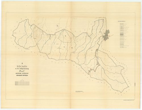
| Title | A Técsői m. Kir. erdőgondnokság „B”és „C” gazdasági osztályának átnézeti térképe. |
425. Likavai kincstári uradalom átnézeti térképe. [B IX c 960]
Institute and Museum of Military History •
B IX c
•
B IX Ausztria–Magyarország
•
B I–XV. Európa
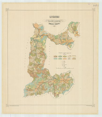
| Title | Likavai kincstári uradalom átnézeti térképe. |
426. Carte du Diocese de Breslau, avec ses IV. Archidiaconats, su... [B IX c 1008]
Institute and Museum of Military History •
B IX c
•
B IX Ausztria–Magyarország
•
B I–XV. Európa
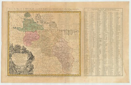
| Title | Carte du Diocese de Breslau, avec ses IV. Archidiaconats, subdivisés en ses Cercles Archipresbyteriales. |
| Main title | Breslau (Wročław) egyházmegye négy kerületének térképe 1751-ben. |
427. Mappa Dioecesium Bosnensis seu Diakovariensis et Syrmiensis. [B IX c 1009]
Institute and Museum of Military History •
B IX c
•
B IX Ausztria–Magyarország
•
B I–XV. Európa
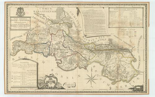
| Title | Mappa Dioecesium Bosnensis seu Diakovariensis et Syrmiensis. |
| Main title | A Diakovári és Szerémség egyházmegye térképe 1826-ban. |
428. Automobil- und Radfahrer-Karten G. Freytags. – Blatt 44. [Bu... [B IX c 1011]
Institute and Museum of Military History •
B IX c
•
B IX Ausztria–Magyarország
•
B I–XV. Európa
| Title | Automobil- und Radfahrer-Karten G. Freytags. – Blatt 44. [Budapest–Pécs. (Fünfkirchen.)] |
| Main title | A Dunántúl D-i részének autó- és úttérképe 1910 körül. |
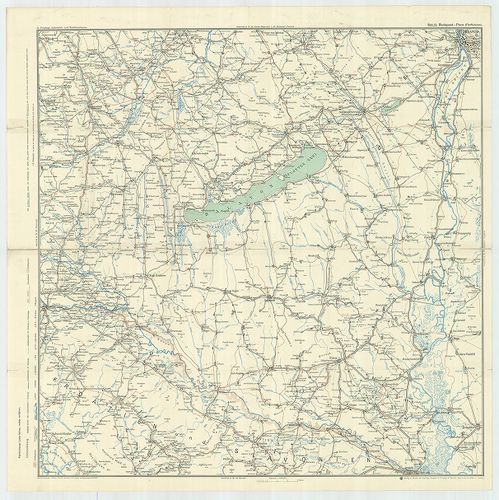
429. Neue Verkehrskarte von Österreich–Ungarn. G. Freytag’s [B IX c 1012]
Institute and Museum of Military History •
B IX c
•
B IX Ausztria–Magyarország
•
B I–XV. Európa
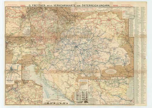
| Title | Neue Verkehrskarte von Österreich–Ungarn. G. Freytag’s |
| Main title | 5 mt. 1. Wiener Lokalverkehr. (Bécsi helyi közlekedés.) 2. Wiener Stadtbahn. (Bécsi városi vasút.) 3. Budapest. 4. Nord-Böhmen. (É-Csehország.) 5. Mittel-Europa. (Közép-Európa–Románia–Bulgária és Törökország.) |
| Subject | Ausztria–Magyarország közlekedési térképe 1900-ban. |
430. Croquis der Strasse von Brčka nach Tuzla. [B IX c 1035]
Institute and Museum of Military History •
B IX c
•
B IX Ausztria–Magyarország
•
B I–XV. Európa
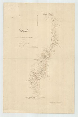
| Title | Croquis der Strasse von Brčka nach Tuzla. |
| Main title | Brčka és Tuzla közötti út terepábrázolása 1878-ban. |
431. Das Abstimmungsgebiet in Kärnten. [B IX c 1040]
Institute and Museum of Military History •
B IX c
•
B IX Ausztria–Magyarország
•
B I–XV. Európa
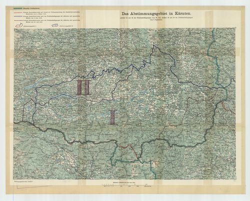
| Title | Das Abstimmungsgebiet in Kärnten. |
| Main title | Karintia népszavazás alá eső területének térképe 1919-ben. |
432. Die Gegend von Gmünd. [B IX c 1040/1]
Institute and Museum of Military History •
B IX c
•
B IX Ausztria–Magyarország
•
B I–XV. Európa
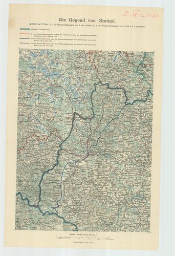
| Title | Die Gegend von Gmünd. |
| Main title | Gmünd környéke 1919-ben. A népszavazás alá eső terület. |
433. Magyarország néprajzi térképe az 1910. évi népszámlálás adat... [B IX c 1041]
Institute and Museum of Military History •
B IX c
•
B IX Ausztria–Magyarország
•
B I–XV. Európa
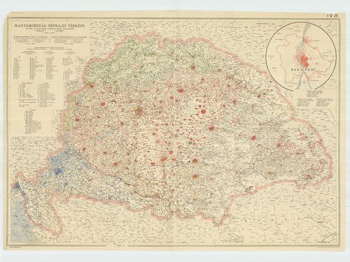
| Title | Magyarország néprajzi térképe az 1910. évi népszámlálás adatainak alapján. – Ethnographical Map of Hungary. – Carte Ethnographique de la Hongrie. |
| Main title | Mt. [Budapest néprajzi térképe.] |
434. Magyarország néprajzi térképe. Az 1910. évi népszámlálás ada... [B IX c 1041/1]
Institute and Museum of Military History •
B IX c
•
B IX Ausztria–Magyarország
•
B I–XV. Európa
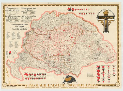
| Title | Magyarország néprajzi térképe. Az 1910. évi népszámlálás adatainak alapján. – Ethnographical Map of Hungary. – Carte Ethnographique de la Hongrie. |
435. Touristenkarte der Section „Hermannstadt” des Siebenbürgisch... [B IX c 1042]
Institute and Museum of Military History •
B IX c
•
B IX Ausztria–Magyarország
•
B I–XV. Európa
| Title | Touristenkarte der Section „Hermannstadt” des Siebenbürgischen Karpathen-Vereines. |
| Main title | Nagyszeben (Sibiu) környékének turistatérképe 1912-ben. |
436. A magyarul tudók száma és aránya járásonként Magyarországon.... [B IX c 1044/1]
Institute and Museum of Military History •
B IX c
•
B IX Ausztria–Magyarország
•
B I–XV. Európa
| Title | A magyarul tudók száma és aránya járásonként Magyarországon. – Nombre et proportion des personnes parlant Hongrois, par districts de la Hongrie. – Number and proportion of persons speaking Hungarian by circuits in Hungary. |
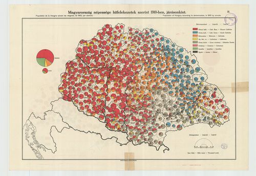
| Main title | Magyarország népessége hitfelekezetek szerint 1910-ben járásonként. – Population de la Hongrie suivant les religions en 1910. par district. – Population of Hungary according to denomination in 1910 by circuits. |
437. [Magyarország.] A Magyar nyelvjárások. [B IX c 1044/2]
Institute and Museum of Military History •
B IX c
•
B IX Ausztria–Magyarország
•
B I–XV. Európa
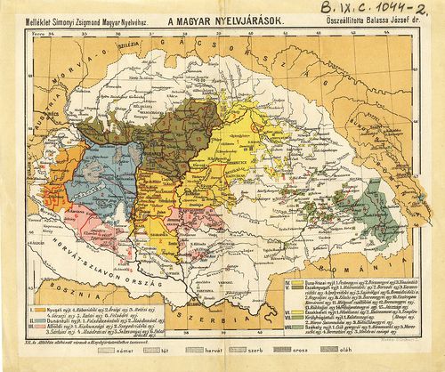
| Title | [Magyarország.] A Magyar nyelvjárások. |
| Main title | Simonyi Zsigmond „Magyar Nyelv.” c. művének mell. |
438. [Magyarország.] A 6 [hat] évesnél idősebb írni-olvasni tudók... [B IX c 1044/3]
Institute and Museum of Military History •
B IX c
•
B IX Ausztria–Magyarország
•
B I–XV. Európa
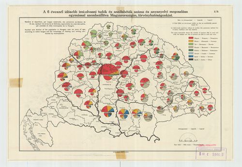
| Title | [Magyarország.] A 6 [hat] évesnél idősebb írni-olvasni tudók és analfabéták száma és anyanyelvi megoszlása egymással szembeállítva Magyarországon, törvényhatóságonként. – Nombre et répartition, par Iangue maternelle, des personnes au – dessus de 6 ans, sachant lire et écrire et illetrées, rapprochées les unes des autres par comitats et villes municipales de la Hongrie. – Number and division of the population in Hungary over six years of age, according to native tongue and the knowledge of reading and writing, confronted by municipalities. |
| Main title | Az Írni-olvasni tudók száma és aránya járásonként Magyarországon a 6 éven aluliak beszámításával. – Nombre et proportion des personnes sachant lire et ecrire, au-dessus de 6 ans y compris, celles comptées par districts de la Hongrie. – Number and proportion of persons able to read and write in Hungary, by circuits, including persons under 6 year of age. |
439. Magyarország Fő- és Középfokú iskolái Mária Terézia korában.... [B IX c 1045]
Institute and Museum of Military History •
B IX c
•
B IX Ausztria–Magyarország
•
B I–XV. Európa
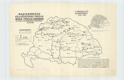
| Title | Magyarország Fő- és Középfokú iskolái Mária Terézia korában. Az 1766-ik évi országos összeírás alapján. |
| Main title | Mt. A tankerületi főigazgatóságok 1776–1784. |
440. Magyarország fő- és középfokú iskolái 1846-ban. [B IX c 1045/1]
Institute and Museum of Military History •
B IX c
•
B IX Ausztria–Magyarország
•
B I–XV. Európa
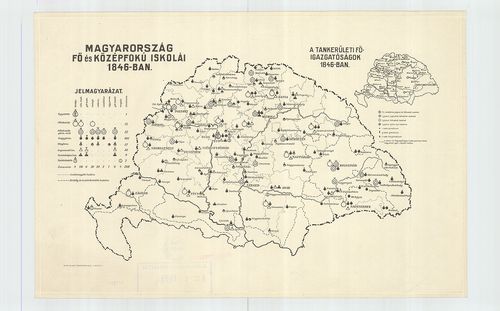
| Title | Magyarország fő- és középfokú iskolái 1846-ban. |
| Main title | Mt. A tankerületi főigazgatóságok 1846-ban. |