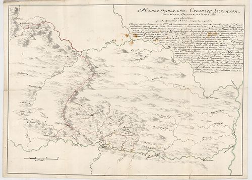
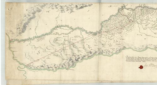
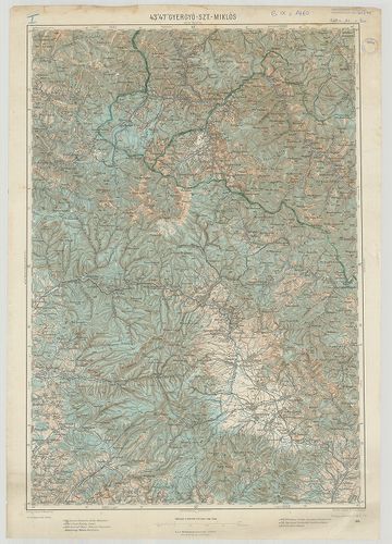
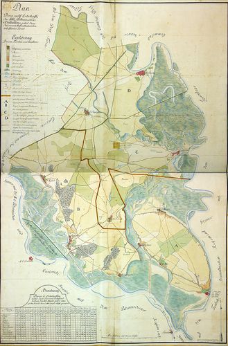
601. Háromszögelési alaplapvázlat. Esztergom, Tolna, Pest-Pilis-S... [B IX c 1378/22]
Institute and Museum of Military History •
B IX c
•
B IX Ausztria–Magyarország
•
B I–XV. Európa
| Title | Háromszögelési alaplapvázlat. Esztergom, Tolna, Pest-Pilis-Solt-Kiskun, Bács-Bodrog, Hont, Fejér, Nógrád megye. |
602. Szabolcs, Hajdú, Zemplén, Bihar megye. [B IX c 1378/23]
Institute and Museum of Military History •
B IX c
•
B IX Ausztria–Magyarország
•
B I–XV. Európa
| Title | Szabolcs, Hajdú, Zemplén, Bihar megye. |
603. Háromszögelési alaplapvázlat. Pest-Pilis-Solt-Kiskun, Nógrád... [B IX c 1378/24]
Institute and Museum of Military History •
B IX c
•
B IX Ausztria–Magyarország
•
B I–XV. Európa
| Title | Háromszögelési alaplapvázlat. Pest-Pilis-Solt-Kiskun, Nógrád, Bács-Bodrog megye. |
604. Háromszögelési alaplapvázlat. Szabolcs-Szatmár, Bereg, Ung, ... [B IX c 1378/25]
Institute and Museum of Military History •
B IX c
•
B IX Ausztria–Magyarország
•
B I–XV. Európa
| Title | Háromszögelési alaplapvázlat. Szabolcs-Szatmár, Bereg, Ung, Bohar, Zemplén megye. |
605. Háromszögelési alaplapvázlat. Győr, Pozsony, Komárom, Fejér,... [B IX c 1378/26]
Institute and Museum of Military History •
B IX c
•
B IX Ausztria–Magyarország
•
B I–XV. Európa
| Title | Háromszögelési alaplapvázlat. Győr, Pozsony, Komárom, Fejér, Sopron, Moson, Veszprém megye. |
606. Háromszögelési alaplapvázlat. Veszprém, Vas, Zala, Somogy me... [B IX c 1378/27]
Institute and Museum of Military History •
B IX c
•
B IX Ausztria–Magyarország
•
B I–XV. Európa
| Title | Háromszögelési alaplapvázlat. Veszprém, Vas, Zala, Somogy megye. |
607. Háromszögelési alaplapvázlat. Gömör, Borsod, Csongrád, Toron... [B IX c 1378/28]
Institute and Museum of Military History •
B IX c
•
B IX Ausztria–Magyarország
•
B I–XV. Európa
| Title | Háromszögelési alaplapvázlat. Gömör, Borsod, Csongrád, Torontál, Heves, Jász-Nagykun, Szolnok, Pest-Pilis-Solt-Kiskun megye. |
608. Háromszögelési alaplapvázlat. Békés, Csanád, Abaúj, Torna, B... [B IX c 1378/29]
Institute and Museum of Military History •
B IX c
•
B IX Ausztria–Magyarország
•
B I–XV. Európa
| Title | Háromszögelési alaplapvázlat. Békés, Csanád, Abaúj, Torna, Borsod, Hajdú, Jász-Nagykun, Szolnok, Szabolcs, Arad megye. |
609. Az Osztrák–Magyar Monarchia gazdasága és kultúrája. [B IX c 1379]
Institute and Museum of Military History •
B IX c
•
B IX Ausztria–Magyarország
•
B I–XV. Európa
| Title | Az Osztrák–Magyar Monarchia gazdasága és kultúrája. |
| Main title | 2 mt.: 1. Az írni-olvasni tudók a XX. század elején. |
| Subject | 2. Az Osztrák–Magyar Monarchia nemzetiségei 1910-ben. |
610. Postkarte von Ungarn und Siebenbürgen. [B IX c 1380]
Institute and Museum of Military History •
B IX c
•
B IX Ausztria–Magyarország
•
B I–XV. Európa
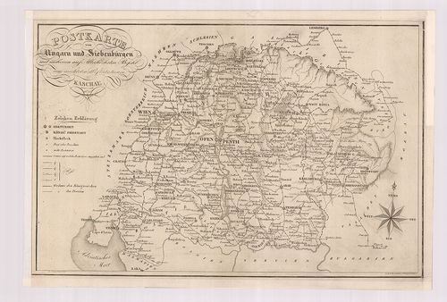
| Title | Postkarte von Ungarn und Siebenbürgen. |
| Main title | Magyarország és Erdély postatérképe 1826-ban. |
611. Planum exhibens postali districtui Cassoviensi incorportarum... [B IX c 1381]
Institute and Museum of Military History •
B IX c
•
B IX Ausztria–Magyarország
•
B I–XV. Európa
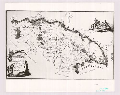
| Title | Planum exhibens postali districtui Cassoviensi incorportarum, incorporandarum, item et projectatarum stationum situm. |
| Main title | A kassai postakerület áttekintő térképe. |
612. Delinatio ductum neo-st ruendae commercialis viae in Gallici... [B IX c 1382]
Institute and Museum of Military History •
B IX c
•
B IX Ausztria–Magyarország
•
B I–XV. Európa
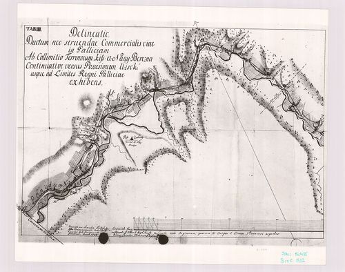
| Title | Delinatio ductum neo-st ruendae commercialis viae in Galliciam ab regiocamreli oppido Unghvar usque ad collimititum terrenorum Kis et Nagy Berezna re monstrans. Tab III. |
| Main title | A Galliciába vezető kereskedelmi út Ungvár és Nagybrezna közti szakaszának térképének a harmadik szelvénye. |
613. Galizien (Karpathen), Bukowina nebst anschiesendem Ungarn, R... [B IX c 1383]
Institute and Museum of Military History •
B IX c
•
B IX Ausztria–Magyarország
•
B I–XV. Európa
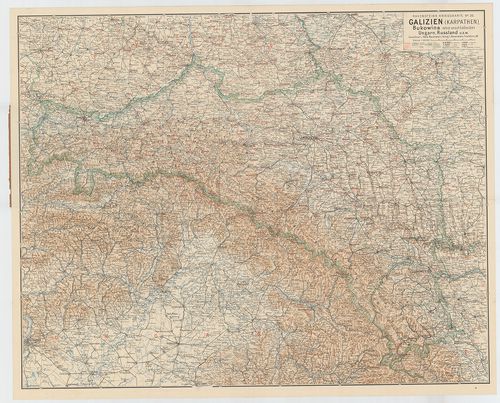
| Title | Galizien (Karpathen), Bukowina nebst anschiesendem Ungarn, Russland U. s. w. (Ludwig Ravensteins Kriegskarte N. 26.) |
| Main title | Galícia, Bukovina, Magyarország, Oroszország csatlakozó részeinek térképe az I. Világháborús frontvonalak, csaták, erődök jelölésével. |
614. Übersichtskarte der Grandmessungs-Arbeiten in der Oesterreic... [B IX c 1384]
Institute and Museum of Military History •
B IX c
•
B IX Ausztria–Magyarország
•
B I–XV. Európa
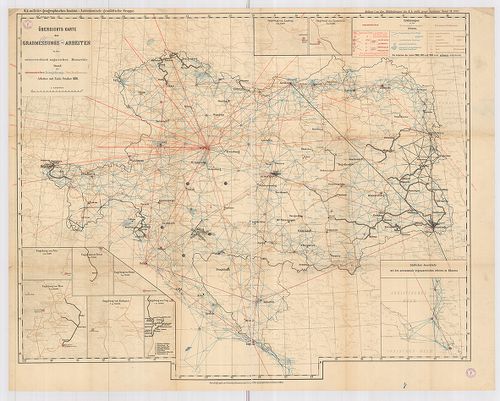
| Title | Übersichtskarte der Grandmessungs-Arbeiten in der Oesterreichisch–Ungarischen Monarchie. Stau der astronomischen, Triangularungs-Präc. Nivellements. |
| Main title | 9 mt.: 1–8.: Umgebung von Lemberg; Czernowitz; Pola; Triest; Fiume; Wien; Budapest; Prag. 9.) Südlicher Anscluss mit den astronomisch-trigonometrischen Arbeiten in Albenien. (Csillagászati-trigonometriai munkák Albániában.) Az Osztrák–Magyar Monarchia fokmérési-munkálatainak áttekintő térképe. Csillagászati, háromszögelési, szabatos szintezési munkálatok. |
615. Magyarország az Anjouk és Zsigmond korában (1301–1437.) [B IX c 1385]
Institute and Museum of Military History •
B IX c
•
B IX Ausztria–Magyarország
•
B I–XV. Európa
| Title | Magyarország az Anjouk és Zsigmond korában (1301–1437.) |
616. Postkarte Samtlicher K. K. teutsch und hungarischen Erblaend... [B IX c 1386]
Institute and Museum of Military History •
B IX c
•
B IX Ausztria–Magyarország
•
B I–XV. Európa
| Title | Postkarte Samtlicher K. K. teutsch und hungarischen Erblaender. |
| Main title | Az Osztrák Császárság postatérképe 1788-ból. faximile kiadásban. |
617. Militärterritorial Ergänzungsbezirkseinteilung. [B IX c 1388]
Institute and Museum of Military History •
B IX c
•
B IX Ausztria–Magyarország
•
B I–XV. Európa
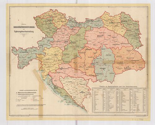
| Title | Militärterritorial Ergänzungsbezirkseinteilung. |
| Main title | Az Osztrák–Magyar Monarchia katonai területi és hadkiegészítő kerület beosztási térképe. |
618. Eisenbahn-Karte der Österreichisch–Ungarischen Monarchie. [B IX c 1389]
Institute and Museum of Military History •
B IX c
•
B IX Ausztria–Magyarország
•
B I–XV. Európa
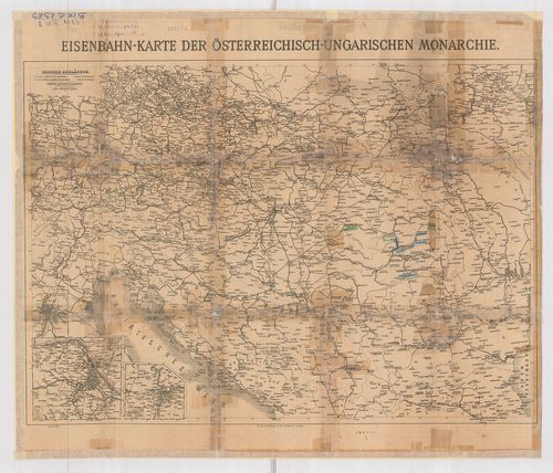
| Title | Eisenbahn-Karte der Österreichisch–Ungarischen Monarchie. |
| Main title | 2 mt.: 1.) Bezirke de Stadt Wien. 2.) Prager Stadtviertel. A hátoldalon: Eisenbahn-Karte von Mittel-Europa. |
| Subject | Az Osztrák–Magyar Monarchia és Közép-Európa vasúti térképe. |
619. Eisenbahnkarte der Österreichisch–Ungarischen Monarchie. [B IX c 1390]
Institute and Museum of Military History •
B IX c
•
B IX Ausztria–Magyarország
•
B I–XV. Európa
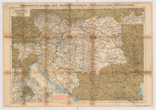
| Title | Eisenbahnkarte der Österreichisch–Ungarischen Monarchie. |
| Main title | 2 mt.: 1.) Bezirke der Stadt Wien. 2.) Prager Stadtviertel. A hátoldalon: Eisenbahn-routen-karte von Mittel-Europa. |
| Subject | Az Osztrák–Magyar Monarchia és Közép-Európa vasúti térképe. |
620. Hrvatska u doba narodnik uladara. Hrvatcka u kasnom srednjem... [B IX c 1391]
Institute and Museum of Military History •
B IX c
•
B IX Ausztria–Magyarország
•
B I–XV. Európa
| Title | Hrvatska u doba narodnik uladara. Hrvatcka u kasnom srednjem vijeku. |
| Main title | Horvátország történeti térképvázlatai VII–XVI. sz.-ig. |
621. Mappa Lineae Limitaneae Utriusq Imperiy Caesarei et Ottomani... [B IX c 1392]
Institute and Museum of Military History •
B IX c
•
B IX Ausztria–Magyarország
•
B I–XV. Európa
| Title | Mappa Lineae Limitaneae Utriusq Imperiy Caesarei et Ottomanici juxta Instrumentum Pacis Statuum in Conventu Carlovitzensi, Valachis et Venetis. |
| Main title | A karlócai békeszerződés határvonala a Császári Birodalom és a Török Birodalom között. |
622. Festungs Sections Plan: 1.) von Raibl. [B IX c 1393]
Institute and Museum of Military History •
B IX c
•
B IX Ausztria–Magyarország
•
B I–XV. Európa
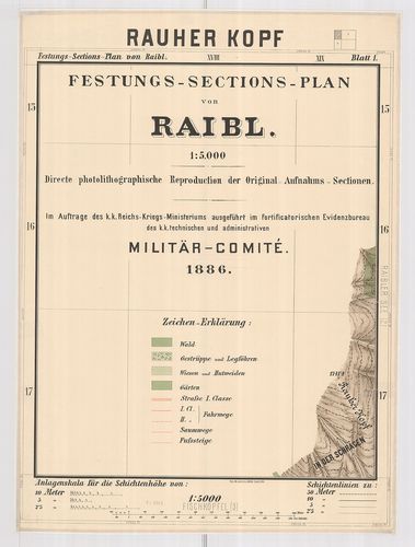
| Title | Festungs Sections Plan: 1.) von Raibl. |
| Main title | 2.) der Sperre Flitsch |
| Subject | 3.) von Predil. |
623. Neueste Uibersichts-Karte der Bezirk-Eintheilung, Eisenbahne... [B IX c 1394]
Institute and Museum of Military History •
B IX c
•
B IX Ausztria–Magyarország
•
B I–XV. Európa
| Title | Neueste Uibersichts-Karte der Bezirk-Eintheilung, Eisenbahnen, Strassen, Post- und Telegrafenstationen Galizien s. u. der Bukovina 1867. |
624. Tabula Generalis Universa Regni Hungariae, Slavoniae ac S˙rm... [B IX c 1395]
Institute and Museum of Military History •
B IX c
•
B IX Ausztria–Magyarország
•
B I–XV. Európa
| Title | Tabula Generalis Universa Regni Hungariae, Slavoniae ac S˙rmü Salis Officia… |
| Main title | A Magyar Királyság, Szlavónia általános térképe, jelölve a sószállító útvonalakat. |
625. Exhibeus partem Fluvy Tübisci ... [B IX c 1396]
Institute and Museum of Military History •
B IX c
•
B IX Ausztria–Magyarország
•
B I–XV. Európa
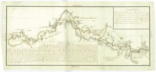
| Title | Exhibeus partem Fluvy Tübisci ... |
| Main title | A Tisza Bocskó és Tiszaújlak közötti szakasza a folyó menti betelepülések jelölésével. A sószállítóútvonalak átrakodóhelyek jelölve. (eredeti térkép OL) |
626. Dislocations Karte der im Königreich Hungarn bequartirten K.... [B IX c 1397]
Institute and Museum of Military History •
B IX c
•
B IX Ausztria–Magyarország
•
B I–XV. Európa
| Title | Dislocations Karte der im Königreich Hungarn bequartirten K. Königleichen Truppen. |
| Main title | A Magyar Királyság diszlokációs térképe a királyi csapatok szálláshelyeivel. |
627. General-Charte des Königreich Hungarn min Einbegriß des Teme... [B IX c 1398]
Institute and Museum of Military History •
B IX c
•
B IX Ausztria–Magyarország
•
B I–XV. Európa
| Title | General-Charte des Königreich Hungarn min Einbegriß des Temeswarer Banat, des Königreich Slavonien und Croatien in 54 Comitate ... |
| Main title | A Magyar Királyság általános térképe a Temesi-Bánsággal, Szlavóniával és Horvátországgal, 54 megyére osztva. A területek mozgósítási táblázata. |
628. Militär-Territorial-Benörden und Dislokation des Heeresim Fe... [B IX c 1399]
Institute and Museum of Military History •
B IX c
•
B IX Ausztria–Magyarország
•
B I–XV. Európa
| Title | Militär-Territorial-Benörden und Dislokation des Heeresim Februar 1848. |
| Main title | A csapatok diszlokációja és az elhelyezési körzetek. |
629. Ergänzungsbezirks-Eintheilung der Jäger-Truppen. [B IX c 1400]
Institute and Museum of Military History •
B IX c
•
B IX Ausztria–Magyarország
•
B I–XV. Európa
| Title | Ergänzungsbezirks-Eintheilung der Jäger-Truppen. |
| Main title | A vadász-csapatok területi elhelyezkedése. |
630. A magyar királyság vármegyéinek címeres pecsétei XVII–XIX. s... [B IX c 1401]
Institute and Museum of Military History •
B IX c
•
B IX Ausztria–Magyarország
•
B I–XV. Európa
| Title | A magyar királyság vármegyéinek címeres pecsétei XVII–XIX. sz. |
631. Aufnahmskarte der wirklichen Grenzen zwischen dem Königreic... [B IX c 1402]
Institute and Museum of Military History •
B IX c
•
B IX Ausztria–Magyarország
•
B I–XV. Európa
| Title | Aufnahmskarte der wirklichen Grenzen zwischen dem Königreich Ungarn u. dem Erzherzoghtum Österreich unter der Ens.... |
| Main title | A Magyar Királyság határtérképe Alsó-Ausztria felé. |
632. Carte von dem in Ungarn zwischen Peterwardein und Szegedin s... [B IX c 1403]
Institute and Museum of Military History •
B IX c
•
B IX Ausztria–Magyarország
•
B I–XV. Európa
| Title | Carte von dem in Ungarn zwischen Peterwardein und Szegedin so wohl Astronomisch als Trigonometrisch gemessenen. |
633. Mappa Geographica Transylvaniam a Banatu Temisvariensi Separ... [B IX c 1404]
Institute and Museum of Military History •
B IX c
•
B IX Ausztria–Magyarország
•
B I–XV. Európa
| Title | Mappa Geographica Transylvaniam a Banatu Temisvariensi Separantes Limites... |
| Main title | Erdély és a Temesi Bánság földrajzi térképe a határok feltüntetésével. Határtérkép. |
634. A magyar királyság szabad királyi városainak címerei és pecs... [B IX c 1405]
Institute and Museum of Military History •
B IX c
•
B IX Ausztria–Magyarország
•
B I–XV. Európa
| Title | A magyar királyság szabad királyi városainak címerei és pecsétjei a XVIII–XIX. sz.-ban. |
635. Erdély és a kiváltságos területi-közigazgatási egységek címe... [B IX c 1406]
Institute and Museum of Military History •
B IX c
•
B IX Ausztria–Magyarország
•
B I–XV. Európa
| Title | Erdély és a kiváltságos területi-közigazgatási egységek címerei és „petsétjei” a történeti Magyarországon. |
636. [A törökellenes magyarországi határvédelem térképe.] [B IX c 1407]
Institute and Museum of Military History •
B IX c
•
B IX Ausztria–Magyarország
•
B I–XV. Európa
| Title | [A törökellenes magyarországi határvédelem térképe.] |
637. [Mappa Mercantilis] - Mappa Geographica facta in usum Commer... [B IX c 1408]
Institute and Museum of Military History •
B IX c
•
B IX Ausztria–Magyarország
•
B I–XV. Európa
| Title | [Mappa Mercantilis] - Mappa Geographica facta in usum Commerciorum. |
| Main title | Földrajzi térkép, amely kereskedők használatára készült.[Kereskedelmi térkép]. |
638. A Fekete-Körös menti táj 1822. [B IX c 1410]
Institute and Museum of Military History •
B IX c
•
B IX Ausztria–Magyarország
•
B I–XV. Európa
| Title | A Fekete-Körös menti táj 1822. |
639. A Duna–Tisza köze élőhelytérképe a 19. sz. végén. [B IX c 1411]
Institute and Museum of Military History •
B IX c
•
B IX Ausztria–Magyarország
•
B I–XV. Európa
| Title | A Duna–Tisza köze élőhelytérképe a 19. sz. végén. |
640. Magyarország vízierői 1897–1903. évi fölvételének körébe von... [B IX c 1412]
Institute and Museum of Military History •
B IX c
•
B IX Ausztria–Magyarország
•
B I–XV. Európa
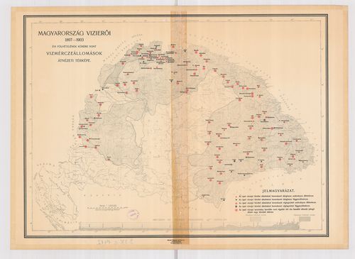
| Title | Magyarország vízierői 1897–1903. évi fölvételének körébe vont vízmérceállomások átnézeti térképe. |
641. Magyarország (X–XI. sz.) [B IX c 1413]
Institute and Museum of Military History •
B IX c
•
B IX Ausztria–Magyarország
•
B I–XV. Európa
| Title | Magyarország (X–XI. sz.) |
| Main title | 1 mt: Egyházmegyék 1038-ban |
642. Magyarország a Hunyadiak és Jagellók korában (1437×1526.) [B IX c 1414]
Institute and Museum of Military History •
B IX c
•
B IX Ausztria–Magyarország
•
B I–XV. Európa
| Title | Magyarország a Hunyadiak és Jagellók korában (1437×1526.) |
| Main title | 4 Mt.: 1. Várnai csata |
| Subject | 2. A nándorfehérvári csata |
643. A függetlenségi harcok (Magyarország a XVII. században) [B IX c 1415]
Institute and Museum of Military History •
B IX c
•
B IX Ausztria–Magyarország
•
B I–XV. Európa
| Title | A függetlenségi harcok (Magyarország a XVII. században) |
644. Az Osztrák–Magyar Monarchia (1867–1918.) [B IX c 1416]
Institute and Museum of Military History •
B IX c
•
B IX Ausztria–Magyarország
•
B I–XV. Európa
| Title | Az Osztrák–Magyar Monarchia (1867–1918.) |
| Main title | 2 mt. 1. O.–M nemzetiségei 1910. |
| Subject | 2. A vasúthálózat fejlődése Mo. |
645. A Pilis és Dobogókő környéke [B IX c 1418]
Institute and Museum of Military History •
B IX c
•
B IX Ausztria–Magyarország
•
B I–XV. Európa
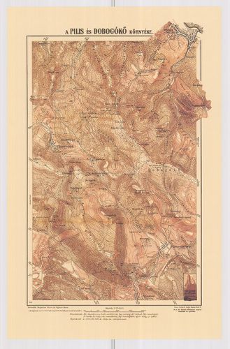
| Title | A Pilis és Dobogókő környéke |
646. A gazdaságok területének megoszlása nagyságkategóriák szerin... [B IX c 1419]
Institute and Museum of Military History •
B IX c
•
B IX Ausztria–Magyarország
•
B I–XV. Európa
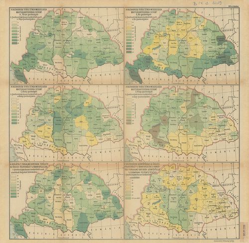
| Title | A gazdaságok területének megoszlása nagyságkategóriák szerint. 6 térkép, statisztikai adatokkal. |
647. Magyarország gazdaságföldrajzi térképe. [B IX c 1420]
Institute and Museum of Military History •
B IX c
•
B IX Ausztria–Magyarország
•
B I–XV. Európa
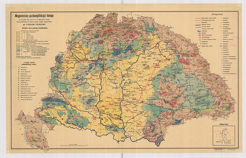
| Title | Magyarország gazdaságföldrajzi térképe. |
648. Limitum post Pacem Carlovitcensem A MDCXCVIII. Mappa Geograp... [B IX c 1421]
Institute and Museum of Military History •
B IX c
•
B IX Ausztria–Magyarország
•
B I–XV. Európa
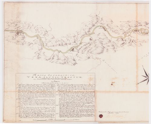
| Title | Limitum post Pacem Carlovitcensem A MDCXCVIII. Mappa Geographica, Tractus Unnae fl. Limitanei inter duo Imperia. |
| Main title | Az 1698. (sic!) évi Karlócai békeszerződés utáni határok földrajzi térképe, amely az Una folyónak a két birodalom közötti határszakaszát ábrázolja. Határtérkép. |
649. Mappa Geographica Unnae Fluvii Tractum, a Kastanovitz, usque... [B IX c 1422]
Institute and Museum of Military History •
B IX c
•
B IX Ausztria–Magyarország
•
B I–XV. Európa
| Title | Mappa Geographica Unnae Fluvii Tractum, a Kastanovitz, usque ad Monasterii rudera, item, Controversum adhuc Territorium Novense, exhibens. |
| Main title | Geográfiai térkép, amely az Una folyót Kastanovitztól a kolostor romjaiig, valamint a még vitatott novi-i területet ábrázolja. Határtérkép. |
650. Mappa Geographica; Lineam, inter utrumque Imperium, Limitane... [B IX c 1423]
Institute and Museum of Military History •
B IX c
•
B IX Ausztria–Magyarország
•
B I–XV. Európa
| Title | Mappa Geographica; Lineam, inter utrumque Imperium, Limitaneam, a Confluxu Savi et Unae ffl., ad montem usque Popinam, ad Mare usque Adriaticum; Compendiose exhibens |
| Main title | Földrajzi térkép, amely a két birodalom határvonalát a Száva és az Una folyók torkolatától a Popina hegyig, és innen a velencei fennhatóságú területekig, egészen az Adriai tengerig, vázlatosan bemutatja. Határtérkép. |
651. Mappa Geographica Tractus Unae fl. Limitanei inter Duo imper... [B IX c 1424]
Institute and Museum of Military History •
B IX c
•
B IX Ausztria–Magyarország
•
B I–XV. Európa
| Title | Mappa Geographica Tractus Unae fl. Limitanei inter Duo imperia... |
| Main title | Földrajzi térkép, amely az Una folyónak a két birodalom közötti szakaszát ábrázolja. Határtérkép. |
652. Mappa Geographica Tractus Limitanei a Sluin, usque ad, Tripl... [B IX c 1425]
Institute and Museum of Military History •
B IX c
•
B IX Ausztria–Magyarország
•
B I–XV. Európa
| Title | Mappa Geographica Tractus Limitanei a Sluin, usque ad, Triplicis Confinii, Punctum... |
| Main title | Szluintól a hármas határ pontjáig terjedő határszakasz geográfiai térképe... Határtérkép. |
653. Mappa Geographica, qua Praecautio contra Pestem instituenda ... [B IX c 1426]
Institute and Museum of Military History •
B IX c
•
B IX Ausztria–Magyarország
•
B I–XV. Európa
| Title | Mappa Geographica, qua Praecautio contra Pestem instituenda [...] ostenditur... |
| Main title | Földrajzi térkép, amelyen a pestis terjedésének megelőzésére hozandó intézkedéseket mutatjuk meg. Határtérkép. |
654. Mappa Geograph. Croatiae Inferior. Inter Unam, Colapim, et S... [B IX c 1427]
Institute and Museum of Military History •
B IX c
•
B IX Ausztria–Magyarország
•
B I–XV. Európa
| Title | Mappa Geograph. Croatiae Inferior. Inter Unam, Colapim, et Savum, sitt., qua ostenditur, quid demolitio Novi, importare possit... |
655. Mappa Geographica Lineae, ad Coranam, fl. Limitaneae, usque ... [B IX c 1428]
Institute and Museum of Military History •
B IX c
•
B IX Ausztria–Magyarország
•
B I–XV. Európa
| Title | Mappa Geographica Lineae, ad Coranam, fl. Limitaneae, usque ad Jeszera [sic], stabilitae, tractum exhibens... |
| Main title | Földrajzi térkép, amely a Corana folyó mentén Jeszeraig futó végleges határszakaszt ábrázolja. Határtérkép. |
656. Mappa Limitanea Regni Croatiae... [B IX c 1429]
Institute and Museum of Military History •
B IX c
•
B IX Ausztria–Magyarország
•
B I–XV. Európa
| Title | Mappa Limitanea Regni Croatiae... |
| Main title | Horvátország határtérképe... |
657. Mappa Generalis Regni Croatiae Totius. [B IX c 1430]
Institute and Museum of Military History •
B IX c
•
B IX Ausztria–Magyarország
•
B I–XV. Európa
| Title | Mappa Generalis Regni Croatiae Totius. |
| Main title | Horvátország térképe..Határtérkép. |
658. Mappa, qua ostenduntur difficultates communicationis Sclavon... [B IX c 1431]
Institute and Museum of Military History •
B IX c
•
B IX Ausztria–Magyarország
•
B I–XV. Európa
| Title | Mappa, qua ostenduntur difficultates communicationis Sclavoniae et Croatiae evacuatis Jeszenovitz et Dubitza |
| Main title | Azon térkép, amelyen bemutatjuk, milyen közlekedési nehézségekkel kell szembenézni Jeszenovitz és Dubitza kiürítése után.Határtérkép. |
659. Mappa Geographica Unnae Fluvii Tractum, a Kastanovitz...Terr... [B IX c 1433]
Institute and Museum of Military History •
B IX c
•
B IX Ausztria–Magyarország
•
B I–XV. Európa
| Title | Mappa Geographica Unnae Fluvii Tractum, a Kastanovitz...Territorium Novense... |
| Main title | Az Una folyó térképe Kastanovitz-től Novi-ig. Határtérkép. |
660. Mappa Geographica Lineae inter utrumque Imperium, Limitaneae... [B IX c 1434]
Institute and Museum of Military History •
B IX c
•
B IX Ausztria–Magyarország
•
B I–XV. Európa
| Title | Mappa Geographica Lineae inter utrumque Imperium, Limitaneae [...] a Confinio Triplici, usque ad Szluin [...] exhibens |
| Main title | Földrajzi térkép, amely a két birodalom között húzódó [...] határokat a hármas határtól Szluinig... mutatja. Határtérkép. |
661. Situations Karte der Kaiser Königlich und Türkisch Croatisch... [B IX c 1435]
Institute and Museum of Military History •
B IX c
•
B IX Ausztria–Magyarország
•
B I–XV. Európa
| Title | Situations Karte der Kaiser Königlich und Türkisch Croatischen Grenze im Karlstaedter Warasdiner Generalat ... |
| Main title | A császári-királyi és török Horvátország határa a Károlyvárosi és a Varasdi Határőrvidékek területén az I. katonai felmérés alapján. Határtérkép. |
662. Mappa Geographica Lineae Limitaneae Particularis utriusque S... [B IX c 1436]
Institute and Museum of Military History •
B IX c
•
B IX Ausztria–Magyarország
•
B I–XV. Európa
| Title | Mappa Geographica Lineae Limitaneae Particularis utriusque Sirmiensis a Salankemen usque ad Confluxum Bozut fl.; et Savensis, inde ad Confluxum Unnae fl. |
| Main title | Földrajzi térkép, amely részletesen ábrázolja egyrészt Salankementől a Bozut folyó torkolatáig a szerémségi, másrészt innen az Una torkolatáig a szávai határvonalat. Határtérkép. |
663. Etnographische Landkarte von Ungarn im Jahre 1910. [B IX c 1438]
Institute and Museum of Military History •
B IX c
•
B IX Ausztria–Magyarország
•
B I–XV. Európa

| Title | Etnographische Landkarte von Ungarn im Jahre 1910. |
| Main title | Magyarország néprajzi térképe 1910-ből. 1940-es kiadás. |
664. Die in Ausssicht genommene Dislokation der ung. Landwehr gle... [B IX c 1439]
Institute and Museum of Military History •
B IX c
•
B IX Ausztria–Magyarország
•
B I–XV. Európa
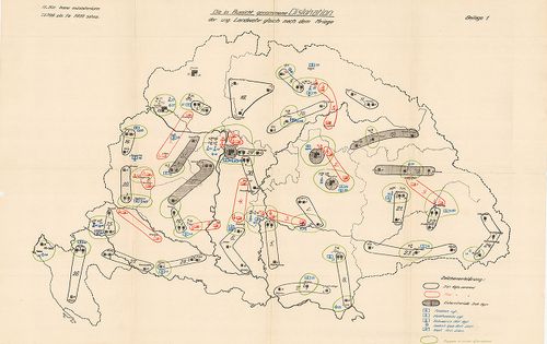
| Title | Die in Ausssicht genommene Dislokation der ung. Landwehr gleich nach dem Kriege. |
| Main title | A Magyar fegyveres erők diszlokációs térképe. |
665. A magyar szent korona állam-területének honvédségi tekintetb... [B IX c 1440]
Institute and Museum of Military History •
B IX c
•
B IX Ausztria–Magyarország
•
B I–XV. Európa
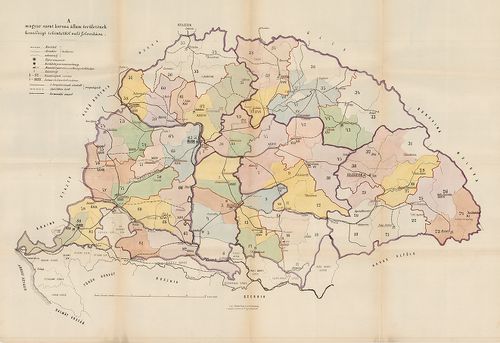
| Title | A magyar szent korona állam-területének honvédségi tekintetből való felosztása |
666. A magyar honfoglalás utjának térképe a névtelen jegyző szeri... [B IX c 1441]
Institute and Museum of Military History •
B IX c
•
B IX Ausztria–Magyarország
•
B I–XV. Európa
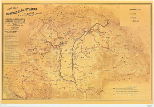
| Title | A magyar honfoglalás utjának térképe a névtelen jegyző szerint. |
667. Schubplan des kais. könig. Gensdarmerie Regiments N 7. [B IX c 1443]
Institute and Museum of Military History •
B IX c
•
B IX Ausztria–Magyarország
•
B I–XV. Európa
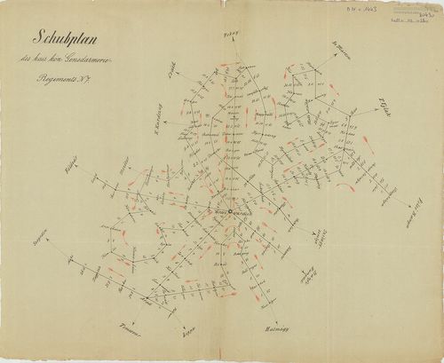
| Title | Schubplan des kais. könig. Gensdarmerie Regiments N 7. |
| Main title | A Nagyváradról kiinduló menetvonalak távolságának térképe a menetidő bejelölésével a 7. csendőrezred működési területén. (1856-1867.) |
668. Herzogtum Salzburg und das Salzkammergut mit den Grenzgebiet... [B IX c 1444]
Institute and Museum of Military History •
B IX c
•
B IX Ausztria–Magyarország
•
B I–XV. Európa
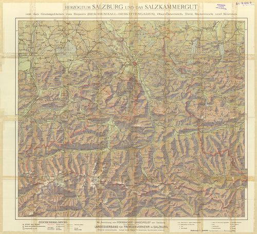
| Title | Herzogtum Salzburg und das Salzkammergut mit den Grenzgebieten von Bayern (Reichenhall – Berchtesgaden), Ober-Österreich Tirol, Steiermark und Kärnten. |
| Main title | Salzburg és környékének térképe. |
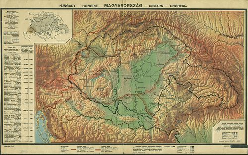
669. Magyarország. [B IX c 1445]
Institute and Museum of Military History •
B IX c
•
B IX Ausztria–Magyarország
•
B I–XV. Európa
| Title | Magyarország. |
| Main title | A magyarság területeinek elhelyezkedése és táblázat a trianoni szerződés következményiről. |
670. Magyar korona országai kézi abrosza. [B IX c 1446]
Institute and Museum of Military History •
B IX c
•
B IX Ausztria–Magyarország
•
B I–XV. Európa
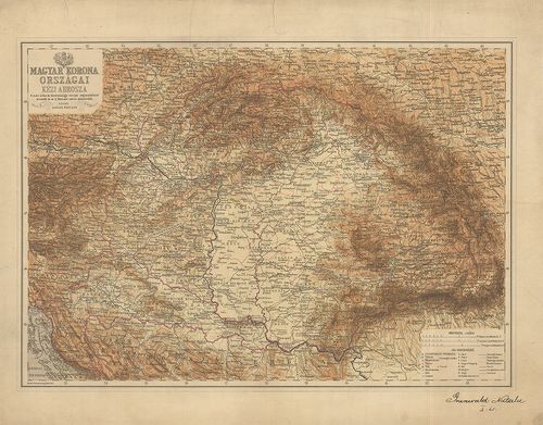
| Title | Magyar korona országai kézi abrosza. |
671. Die Oesterreich.-Ungarischen Eisenbahnen der Gegenwart und Z... [B IX c 1447]
Institute and Museum of Military History •
B IX c
•
B IX Ausztria–Magyarország
•
B I–XV. Európa
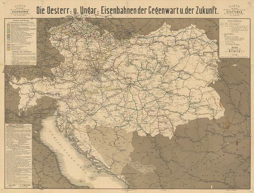
| Title | Die Oesterreich.-Ungarischen Eisenbahnen der Gegenwart und Zukunft. |
| Main title | Az Osztrák-Magyar Monarchia vasúttérképe a jelen- és a jővő időben. |
672. G. Freytags neue Verkehrskarte von Österreich-Ungarn. [B IX c 1448]
Institute and Museum of Military History •
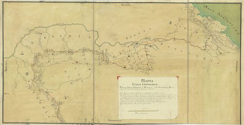
B IX c
•
B IX Ausztria–Magyarország
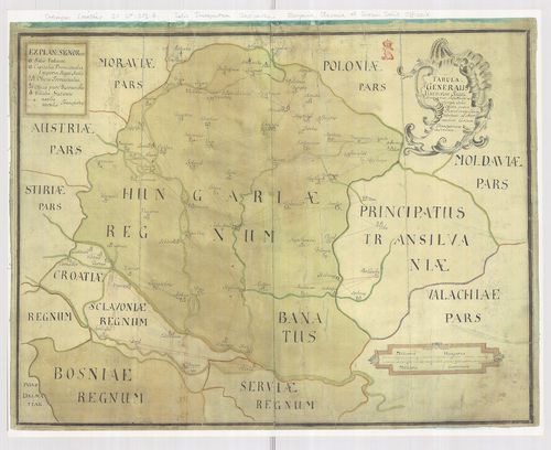
•
B I–XV. Európa
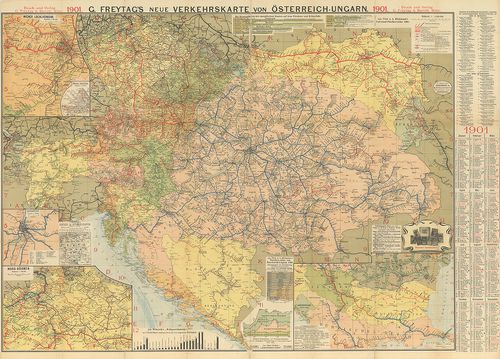
| Title | G. Freytags neue Verkehrskarte von Österreich-Ungarn. |
| Main title | Az Osztrák-Magyar Monarchia új közelekedési térképe 1901-ből. |
673. Velagen u.Klasings Neuer Volk- und Familien -Atlas. Probekar... [B IX c 1449]
Institute and Museum of Military History •
B IX c
•
B IX Ausztria–Magyarország
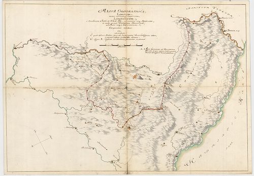
•
B I–XV. Európa
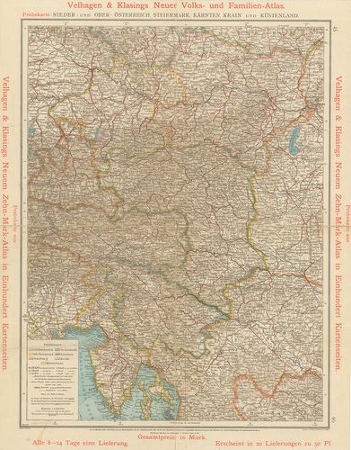
| Title | Velagen u.Klasings Neuer Volk- und Familien -Atlas. Probekarte: Nieder- und ober- Öterreich, Steiermark, Kaerten, Krain und Küstenland. |
| Main title | A Velagen u. Klasings Atlasz próbatérképe: Alsó- és Felső Ausztria, Stájerország, Karintia, Krajna és a magy. tengerpart. |
674. Magyarország Egyházmegyéi. [B IX c 1450]
Institute and Museum of Military History •
B IX c
•
B IX Ausztria–Magyarország
•
B I–XV. Európa
| Title | Magyarország Egyházmegyéi. |
675. A Debrecen-Nyíregyházi Egyházmegye térképe. [B IX c 1451]
Institute and Museum of Military History •
B IX c
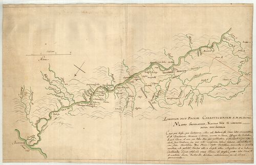
•
B IX Ausztria–Magyarország
•
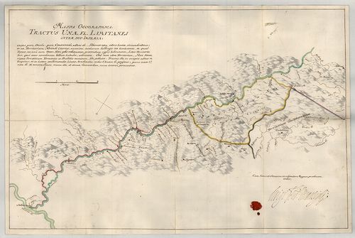
B I–XV. Európa
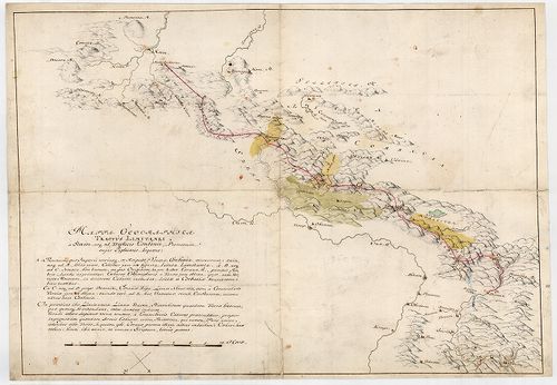
| Title | A Debrecen-Nyíregyházi Egyházmegye térképe. |
676. Az Esztergom-Budapesti Főegyházmegye térképe. [B IX c 1452]
Institute and Museum of Military History •
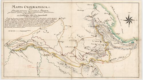
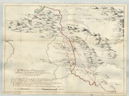
B IX c
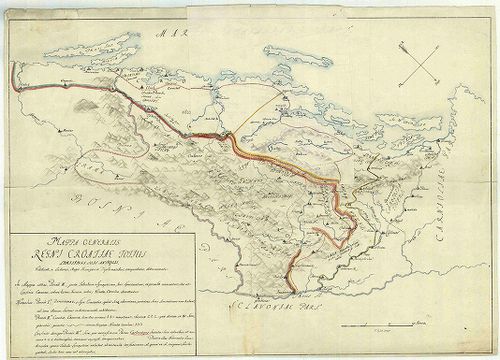
•
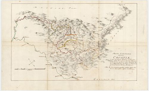
B IX Ausztria–Magyarország
•
B I–XV. Európa
| Title | Az Esztergom-Budapesti Főegyházmegye térképe. |
677. A Veszprémi Főegyházmegye térképe. [B IX c 1453]
Institute and Museum of Military History •
B IX c
•
B IX Ausztria–Magyarország
•
B I–XV. Európa
| Title | A Veszprémi Főegyházmegye térképe. |
678. A Kalocsa-Kecskeméti Főegyházmegye térképe. [B IX c 1454]
Institute and Museum of Military History •
B IX c
•
B IX Ausztria–Magyarország
•
B I–XV. Európa
| Title | A Kalocsa-Kecskeméti Főegyházmegye térképe. |
679. A Magyaroszági Református Egyház térképe. [B IX c 1455]
Institute and Museum of Military History •
B IX c
•
B IX Ausztria–Magyarország
•
B I–XV. Európa
| Title | A Magyaroszági Református Egyház térképe. |
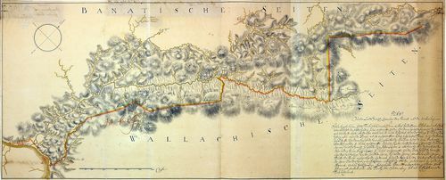
680. Gränz-Karte des Trentschiner Comitats mit den angrenzenden P... [B IX c 1456]
Institute and Museum of Military History •
B IX c
•
B IX Ausztria–Magyarország
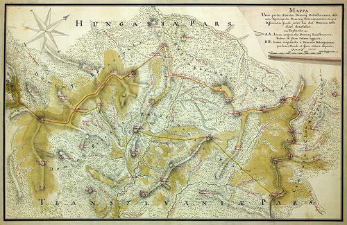
•
B I–XV. Európa
| Title | Gränz-Karte des Trentschiner Comitats mit den angrenzenden Provinzen. |
| Main title | Trencsén megye és a környező területek határtérképe. |
681. Gränz-Karte des Arvenser Comitates mit dem angränzenden Thei... [B IX c 1457]
Institute and Museum of Military History •
B IX c
•
B IX Ausztria–Magyarország
•
B I–XV. Európa
| Title | Gränz-Karte des Arvenser Comitates mit dem angränzenden Theile von Galizien. |
| Main title | Árva megye és a környező területek határtérképe. |
682. Commercielle Special-Karte der Österr-Ungar Monarchie. [B IX c 1458]
Institute and Museum of Military History •
B IX c
•
B IX Ausztria–Magyarország
•
B I–XV. Európa
| Title | Commercielle Special-Karte der Österr-Ungar Monarchie. |
683. Karte von Kärnten. [B IX c 1459]
Institute and Museum of Military History •
B IX c
•
B IX Ausztria–Magyarország
•
B I–XV. Európa
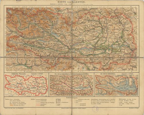
| Title | Karte von Kärnten. |
| Main title | Karintia térképe. |
684. [A bukaresti béke határvonala.] [B IX c 1460]
Institute and Museum of Military History •
B IX c
•
B IX Ausztria–Magyarország
•
B I–XV. Európa
| Title | [A bukaresti béke határvonala.] |
| Main title | A bejárt de ki nem tűzött román-magyar határ közelítő nyomvonala. |
685. Plan von der Landt-Granitz zwischen dem Bannat und der Walac... [B IX c 1461]
Institute and Museum of Military History •
B IX c
•
B IX Ausztria–Magyarország
•
B I–XV. Európa
| Title | Plan von der Landt-Granitz zwischen dem Bannat und der Walachey. |
| Main title | A Bánság és Havasalföld határtérképe. |
686. Mappa vorstellendt die Granitz welcher gestallten nach Inhal... [B IX c 1463]
Institute and Museum of Military History •
B IX c
•
B IX Ausztria–Magyarország
•
B I–XV. Európa
| Title | Mappa vorstellendt die Granitz welcher gestallten nach Inhalt des letzt zu Belgrad 1739 geschlossenen Frieden in Antrag ist ... von Porec an bis zu den Emfluss der Cserna ... etc. |
| Main title | Az 1739-es belgrádi béke után meghatározott határ Porec és a Cserna folyó között. |
687. Mappa unius partis Fiscalis Dominij Halmagiensis et Comitatu... [B IX c 1464]
Institute and Museum of Military History •
B IX c
•
B IX Ausztria–Magyarország
•
B I–XV. Európa
| Title | Mappa unius partis Fiscalis Dominij Halmagiensis et Comitatus Zarandiensis, nec non Episcopatus Dominij Belenyesiensis, in qua Differentia fundi, inter haec duo Dominia orta clare denotatur. |
| Main title | Zaránd megye egy részének térképe a belényesi járás területével, a Magyar Királyság-Erdély határát jelölve 1850-ben. |
688. Mappa unius partis Fiscalis Dominij Zalathnensis, nec non Ep... [B IX c 1465]
Institute and Museum of Military History •
B IX c
•
B IX Ausztria–Magyarország
•
B I–XV. Európa
| Title | Mappa unius partis Fiscalis Dominij Zalathnensis, nec non Episcopatus Dominij Belenyesiensis, in qua Differentia fundi, inter haec duo Dominia orta clare denotatur. |
| Main title | A belényesi járás területe a Magyar Királyság-Erdély határát jelölve 1850-ben. |
689. Geometrischer Plan deren beiden Prädien von St. Peter u. Hor... [B IX c 1466]
Institute and Museum of Military History •
B IX c
•
B IX Ausztria–Magyarország
•
B I–XV. Európa
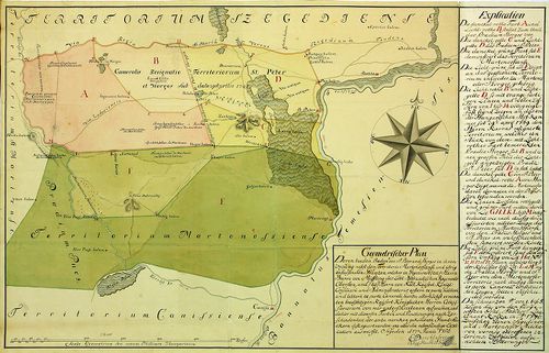
| Title | Geometrischer Plan deren beiden Prädien von St. Peter u. Horgosch ... nebst dem Territorio Martonossiensi ... |
| Main title | Horgos és Martonos geometriai felmérési térképe 1750-ben. |
690. Charte der Gräntz-Controversen zwischen Hungarn und Schlesie... [B IX c 1467]
Institute and Museum of Military History •
B IX c
•
B IX Ausztria–Magyarország
•
B I–XV. Európa
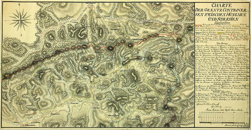
| Title | Charte der Gräntz-Controversen zwischen Hungarn und Schlesien. |
| Main title | A határ egy része Magyarország és Szilézia között. |
691. [A Temesi Bánság néhány települése:Jabuka és Pancsova környé... [B IX c 1468]
Institute and Museum of Military History •
B IX c
•
B IX Ausztria–Magyarország
•
B I–XV. Európa
| Title | [A Temesi Bánság néhány települése:Jabuka és Pancsova környékén.] |
692. Situations Plan von Orsova. [B IX c 1469]
Institute and Museum of Military History •
B IX c
•
B IX Ausztria–Magyarország
•
B I–XV. Európa
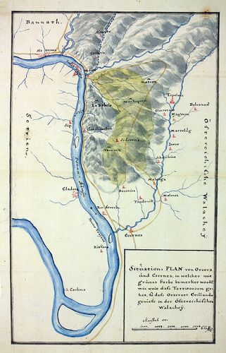
| Title | Situations Plan von Orsova. |
| Main title | Orsova és környéke. |
693. Gränz-Carte des strittigen Antheils zwischen Pohlen u. Ungar... [B IX c 1470]
Institute and Museum of Military History •
B IX c
•
B IX Ausztria–Magyarország
•
B I–XV. Európa
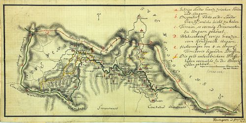
| Title | Gränz-Carte des strittigen Antheils zwischen Pohlen u. Ungarn längs der Grenze der Comitate Arva, Liptau, Zips u. Saros. |
| Main title | Határtérkép Lengyelország és Magyarország között, Árva, Liptó, Szepes és Sáros megyében. |
694. Gränz-Carte des strittigen Antheils zwischen Pohlen u. Ungar... [B IX c 1471]
Institute and Museum of Military History •
B IX c
•
B IX Ausztria–Magyarország
•
B I–XV. Európa
| Title | Gränz-Carte des strittigen Antheils zwischen Pohlen u. Ungarn, die Strecke an denen Gränzen des Arvenser, Liptauer, Zipser u. Saroscher-Comitats betreffend. Der westliche Theil. Levee a la hatte par l'Etat general. |
| Main title | Határtérkép Lengyelország és Magyarország között, Árva, Liptó, Szepes és Sáros megyében. |
695. Gemeindegrenzkarten der in der Zsupaneker Grenze, in der obe... [B IX c 1472]
Institute and Museum of Military History •
B IX c
•
B IX Ausztria–Magyarország
•
B I–XV. Európa
| Title | Gemeindegrenzkarten der in der Zsupaneker Grenze, in der oberen Glisur, in der Almas u. in der Graina liegenden Ortschaften. |
| Main title | Határtérkép Lengyelország és Magyarország között, Árva, Liptó, Szepes és Sáros megyében. |
696. Plan in welchen entworffen, die äussersten Gräntzen der in d... [B IX c 1473]
Institute and Museum of Military History •
B IX c
•
B IX Ausztria–Magyarország
•
B I–XV. Európa

| Title | Plan in welchen entworffen, die äussersten Gräntzen der in dem Karánsebeser District liegenden, vermög. allerhöchster Entschlüssung vom dem Provinciali an das wallachisch-illirische Rgmt. abzutreten bestimmten 14 Ortschaften. |
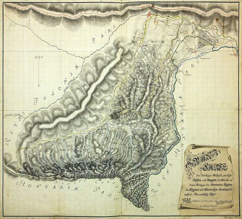
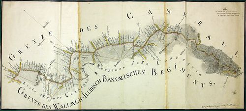
| Main title | Határtérkép a Karánsebesi Kerület 14 településéről. |
697. Plan deren zwölf Ortschafte, des Löbl. Tschaikisten Battaill... [B IX c 1474]
Institute and Museum of Military History •
B IX c
•
B IX Ausztria–Magyarország
•
B I–XV. Európa
| Title | Plan deren zwölf Ortschafte, des Löbl. Tschaikisten Battaillons… |
| Main title | A Csajkások területén 12 település térképe, a gazadasági felmérésből kisebbítve. |
698. Plan der particular Gränz zwischen den Camerale u. von den W... [B IX c 1475]
Institute and Museum of Military History •
B IX c
•
B IX Ausztria–Magyarország
•
B I–XV. Európa
| Title | Plan der particular Gränz zwischen den Camerale u. von den Wall.-Illyr.-Banatischen Rgmt, von Lagerdorf bis nach der Schmeltz Radimuza. |
| Main title | Az Oláh-Illír Bánsági Határőrvidék határának egy része (Nádastól DK-re). |
699. Plan des im löblichen Wallach. Illyr. Gr. Rgmt Globoreur hal... [B IX c 1476]
Institute and Museum of Military History •
B IX c
•
B IX Ausztria–Magyarország
•
B I–XV. Európa
| Title | Plan des im löblichen Wallach. Illyr. Gr. Rgmt Globoreur halben Division liegenden Ortes Toplez so in 8 Wald u. 5 sonstige Riede eingetheilt. |
| Main title | Az Oláh-Illír Bánsági Határőrvidék területe. |
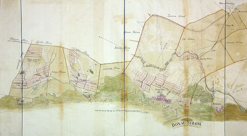
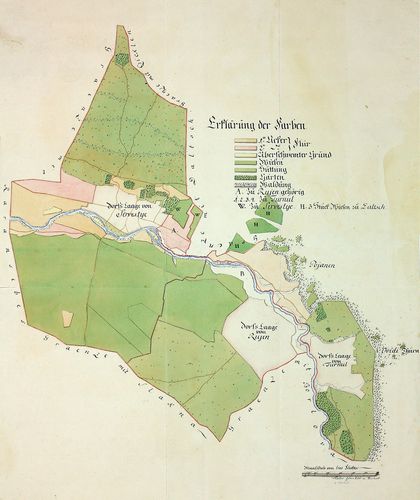
700. Mappa situm Possess. ac. Praediorum Cameraticorum in Inclyti... [B IX c 1477]
Institute and Museum of Military History •
B IX c
•
B IX Ausztria–Magyarország
•
B I–XV. Európa
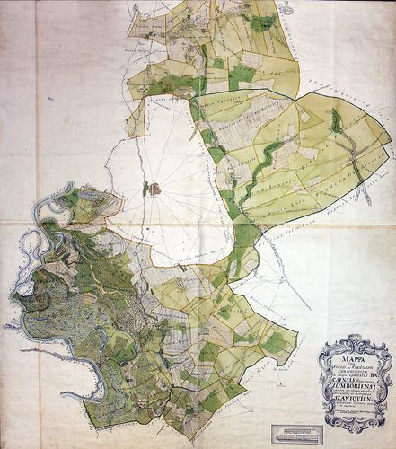
| Title | Mappa situm Possess. ac. Praediorum Cameraticorum in Inclyti Comitatus Bacsensis Provisoratu Zomboriensi habitorum, cum adnexis nonnullis his advicinantibus, ad districtumque Szantoviensem spectantibus Territoriis, accurate exprimens. |
| Main title | Birtoktérkép Bács megyében, Zombor környékén. |