221. I. France. 9. C.(a) [B V c 104]
Institute and Museum of Military History •
B V c
•
B V Franciaország
•
B I–XV. Európa
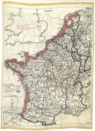
| Title | I. France. 9. C.(a) |
| Main title | Franciaország út és vasúthálózati térképe a II. világháború idején 1942 körül.II. [Németország.] 2. B. |
| Subject | Németország út és vasúttérképe a II. világháború idején 1942 körül. (Genf-Amsterdam -Vilnius-Cluj közötti terület. |
222. Stuttgarter Reliefkarten Nordost-Frankreich und Belgien. – R... [B V c 105]
Institute and Museum of Military History •
B V c
•
B V Franciaország
•
B I–XV. Európa
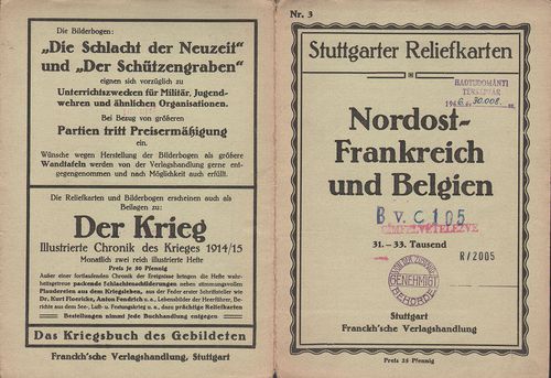
| Title | Stuttgarter Reliefkarten Nordost-Frankreich und Belgien. – Reliefkarte von Nordost-Frankreich. Nr. 3. |
| Main title | Franciaország ÉK-i része és Belgium madártávlati képe 1910 körül. |
223. Reliefkarte vom Ober-Elsass Belfort bis Mülhausen. – Reliefk... [B V c 106]
Institute and Museum of Military History •
B V c
•
B V Franciaország
•
B I–XV. Európa
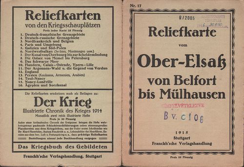
| Title | Reliefkarte vom Ober-Elsass Belfort bis Mülhausen. – Reliefkarte vom Oberelsass (Belfort–Mülhausen) Nr. 17. |
| Main title | Felső Elszász (Belfort–Mulhouse) környékének madártávlati képe 1915-ben. |
224. Stuttgarter Reliefkarten Woevregebiet und Priesterwald. – Re... [B V c 107]
Institute and Museum of Military History •
B V c
•
B V Franciaország
•
B I–XV. Európa
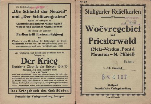
| Title | Stuttgarter Reliefkarten Woevregebiet und Priesterwald. – Reliefkarte vom Woëvre-Gebiet und Priesterwald. (Metz–Verdun und Pont-á-Mousson–St. Mihiel.) Nr. 27. |
| Main title | Metz–Verdun–Pont-á-Mousson és St. Mihiel környékének madártávlati képe 1910 körül. |
225. Tracé de l’autoroute A9 entre Béziers–Narbonne. [B V c 108]
Institute and Museum of Military History •
B V c
•
B V Franciaország
•
B I–XV. Európa
| Title | Tracé de l’autoroute A9 entre Béziers–Narbonne. |
226. Zones de peuplement industriel ou urbain. [B V c 111]
Institute and Museum of Military History •
B V c
•
B V Franciaország
•
B I–XV. Európa
| Title | Zones de peuplement industriel ou urbain. |
227. Carte de la répartition de la population de la France [–1962... [B V c 112]
Institute and Museum of Military History •
B V c
•
B V Franciaország
•
B I–XV. Európa
| Title | Carte de la répartition de la population de la France [–1962.] |
228. Carte de la variation de population de la France par Cantons... [B V c 113]
Institute and Museum of Military History •
B V c
•
B V Franciaország
•
B I–XV. Európa
| Title | Carte de la variation de population de la France par Cantons 1806–1962. |
229. Carte des variations de la population des villes de plus de ... [B V c 114/a]
Institute and Museum of Military History •
B V c
•
B V Franciaország
•
B I–XV. Európa
| Title | Carte des variations de la population des villes de plus de 8000 habitans entre 1936–1954. |
230. Carte des variations de la population des villes de plus de ... [B V c 114/b]
Institute and Museum of Military History •
B V c
•
B V Franciaország
•
B I–XV. Európa
| Title | Carte des variations de la population des villes de plus de 8000 habitans entre 1954–1962. |
231. Francija. Ekonomicseszkaja ucsebnaja karta. [B V c 115/a]
Institute and Museum of Military History •
B V c
•
B V Franciaország
•
B I–XV. Európa
| Title | Francija. Ekonomicseszkaja ucsebnaja karta. |
| Main title | Mt.: O. Korszika. (Korzika.) |
232. Francija. Ekonomicseszkaja ucsebnaja karta. [B V c 115/b]
Institute and Museum of Military History •
B V c
•
B V Franciaország
•
B I–XV. Európa
| Title | Francija. Ekonomicseszkaja ucsebnaja karta. |
233. Aménagement de l’Arc superieur chute du Mont-Cenis. [B V c 116]
Institute and Museum of Military History •
B V c
•
B V Franciaország
•
B I–XV. Európa
| Title | Aménagement de l’Arc superieur chute du Mont-Cenis. |
234. Fond de carte routier de la France. [B V c 117]
Institute and Museum of Military History •
B V c
•
B V Franciaország
•
B I–XV. Európa
| Title | Fond de carte routier de la France. |
| Main title | 5 mt.: 1. Lyon környéke. 2. Marseille környéke. 3. Nice körny. 4. Lille körny. 5. Párizs környéke. |
235. [Franciaország.] Cartoguide Nautique 1963–64. [B V c 118]
Institute and Museum of Military History •
B V c
•
B V Franciaország
•
B I–XV. Európa
| Title | [Franciaország.] Cartoguide Nautique 1963–64. |
236. France Grandes Routes. Carte Michelin les Grandes Routes mai... [B V c 119]
Institute and Museum of Military History •
B V c
•
B V Franciaország
•
B I–XV. Európa
| Title | France Grandes Routes. Carte Michelin les Grandes Routes main Roads. |
237. Frankreich. France. Francia. Carte Automobile. [B V c 120]
Institute and Museum of Military History •
B V c
•
B V Franciaország
•
B I–XV. Európa
| Title | Frankreich. France. Francia. Carte Automobile. |
| Main title | Mt.: Paris. |
238. Carte Michelin de la France. [B V c 121]
Institute and Museum of Military History •
B V c
•
B V Franciaország
•
B I–XV. Európa
| Title | Carte Michelin de la France. |
| Main title | No. 51. Boulogne–Lille. No. 55. Paris–Caen. No. 57. Verdun–Saarebruck (Saarbrücken). No. 61. Paris–Chaumont. No. 62. Chaumont–Strasbourg. No. 74. Lyon–Geneve (Genf). |
239. Frankreich. Shell Reisekarte. Carte automobile Shell Road Ma... [B V c 122]
Institute and Museum of Military History •
B V c
•
B V Franciaország
•
B I–XV. Európa
| Title | Frankreich. Shell Reisekarte. Carte automobile Shell Road Map France. |
| Main title | 6 mt.: 1. Paris. |
| Subject | 2. [Páris környéke.] 3. [Strassbourg–Basel közötti terület.] 4. [Tours–Orleans környéke.] 6. [Genf–Torino környéke.] 6. [Marseille–Nice környéke.] |
240. France Grandes Routes. – Carte Michelin les Grandes Routes M... [B V c 123]
Institute and Museum of Military History •
B V c
•
B V Franciaország
•
B I–XV. Európa
| Title | France Grandes Routes. – Carte Michelin les Grandes Routes Main Roads. |