61. A Part of the N. E. – Coast of the Shetland Isles. [B VI b 4]
Institute and Museum of Military History •
B VI b
•
B VI Anglia, Skócia és Írország
•
B I–XV. Európa
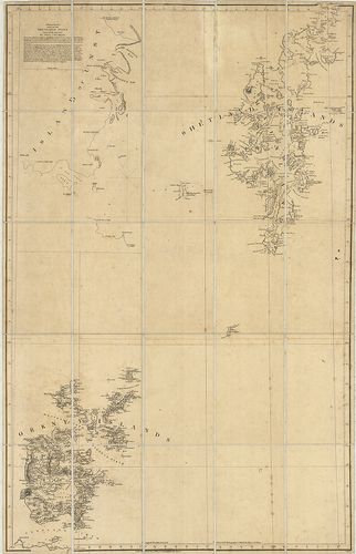
| Title | A Part of the N. E. – Coast of the Shetland Isles. |
| Main title | A Shetland és az Orkney szigetek hegyvízrajzi térképe 1807-ben. |
62. Tavistock and Okehampton. Sheet 137. [B VI b 6]
Institute and Museum of Military History •
B VI b
•
B VI Anglia, Skócia és Írország
•
B I–XV. Európa
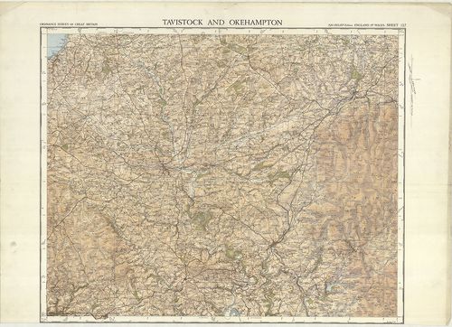
| Title | Tavistock and Okehampton. Sheet 137. |
| Main title | Tavistock és Okehampton környékének topográfiai térképe 1932-ben. |
63. Plymouth. – Physical Features alone. Sheet 144. [B VI b 7]
Institute and Museum of Military History •
B VI b
•
B VI Anglia, Skócia és Írország
•
B I–XV. Európa

| Title | Plymouth. – Physical Features alone. Sheet 144. |
| Main title | Plymouth hegyvízrajzi térképe 1931-ben. |
64. Ordnance Survey of the Isle of Wight and Part of Hampshire. [B VI b 11]
Institute and Museum of Military History •
B VI b
•
B VI Anglia, Skócia és Írország
•
B I–XV. Európa
| Title | Ordnance Survey of the Isle of Wight and Part of Hampshire. |
| Main title | Wight sziget és Hampshire D-i részének topográfiai térképe 1810–1862-ben. |
65. The Irish Channel. Sheet I–II. 1825. A–1825. B. [B VI b 12]
Institute and Museum of Military History •
B VI b
•
B VI Anglia, Skócia és Írország
•
B I–XV. Európa

| Title | The Irish Channel. Sheet I–II. 1825. A–1825. B. |
| Main title | 11 mt.: 1. Belfast Lough. (Belfasti-öböl.) 2. Lough Larne. (Larne-öböl.) 3. Strangford Narrows. (Strangfordi-szoros.) 4. Cambellton Loch. (Cambelltoni öböl.) 5. Lough Carlingford. (Carlingford-öböl.) 6. Kingstown Harbour. (Kingstown kikötő.) 7. Wexford South Bay. (Wexford D-i öböl.) 8. Waterford Harb. (Waterford kikötő.) 9. St. Tudwall Roads. (St. Tudwall-i járatok.) 10. Holyhead Bay. Holyhead öböl.) 11. Milford Haven. (Milford kikötő.) |
| Subject | Az Ír-tenger és az Északi-csatorna partvidékének térképe 1868–1871-ben. |
66. Owers to Christchurch with Spithead and the I. of Wight. 204... [B VI b 13]
Institute and Museum of Military History •
B VI b
•
B VI Anglia, Skócia és Írország
•
B I–XV. Európa
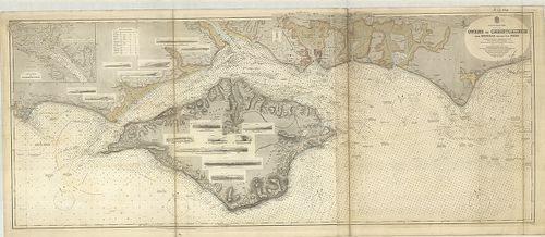
| Title | Owers to Christchurch with Spithead and the I. of Wight. 2045. |
| Main title | Mt.: Continuation of Southampton Water. (Southamptoni víziút.) |
| Subject | A Christchurch-i és Spithead-i öböl partvidékének térképe 1852-ben. |
67. Britannia. [B VI b 15]
Institute and Museum of Military History •
B VI b
•
B VI Anglia, Skócia és Írország
•
B I–XV. Európa
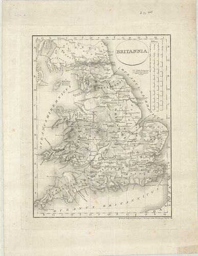
| Title | Britannia. |
| Main title | Anglia hegyvízrajzi térképe 1819-ben. |
68. Angolország hegy és vízrajzi domborművű falitérképe. [B VI b 20]
Institute and Museum of Military History •
B VI b
•
B VI Anglia, Skócia és Írország
•
B I–XV. Európa
| Title | Angolország hegy és vízrajzi domborművű falitérképe. |
69. Britische Inseln. [B VI b 21]
Institute and Museum of Military History •
B VI b
•
B VI Anglia, Skócia és Írország
•
B I–XV. Európa
| Title | Britische Inseln. |
70. Velikobritanija i Irlandija. [B VI b 22]
Institute and Museum of Military History •
B VI b
•
B VI Anglia, Skócia és Írország
•
B I–XV. Európa
| Title | Velikobritanija i Irlandija. |
71. General Post Office Telegraph Map for England and Wales. [B VI c 1]
Institute and Museum of Military History •
B VI c
•
B VI Anglia, Skócia és Írország
•
B I–XV. Európa
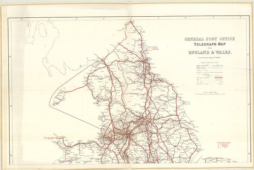
| Title | General Post Office Telegraph Map for England and Wales. |
| Main title | Anglia és Wales postahálózati térképe 1884-ben. |
72. General Post Office Telegraph Map for Ireland. [B VI c 2]
Institute and Museum of Military History •
B VI c
•
B VI Anglia, Skócia és Írország
•
B I–XV. Európa
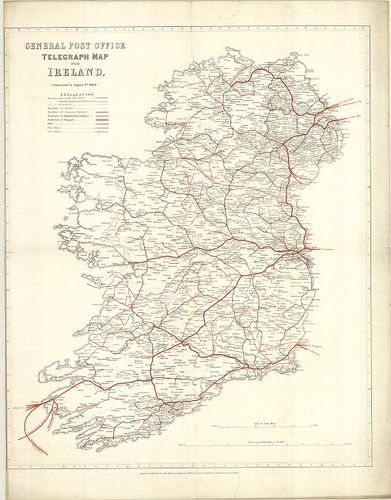
| Title | General Post Office Telegraph Map for Ireland. |
| Main title | Írország postahálózati térképe 1884-ben. |
73. General Post Office Telegraph Map for Scotland. [B VI c 3]
Institute and Museum of Military History •
B VI c
•
B VI Anglia, Skócia és Írország
•
B I–XV. Európa
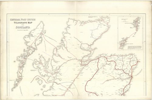
| Title | General Post Office Telegraph Map for Scotland. |
| Main title | Mt.: [Orkney és Shetland szigetek.] |
| Subject | Skócia postahálózati térképe 1884-ben. |
74. Roman Britain. [B VI c 7]
Institute and Museum of Military History •
B VI c
•
B VI Anglia, Skócia és Írország
•
B I–XV. Európa
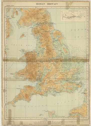
| Title | Roman Britain. |
| Main title | Mt.: The Roman Wall in Scotland. (A római határfal Skóciában.) |
| Subject | Anglia római kori történelmi térképe. |
75. Nagy-Britannia autótérképe. [B VI c 8]
Institute and Museum of Military History •
B VI c
•
B VI Anglia, Skócia és Írország
•
B I–XV. Európa
| Title | Nagy-Britannia autótérképe. |
| Main title | 3 mt.: 1. Channel Islands. |
| Subject | 2. Orkney Islands. |
76. Chart for locating grounds N. B. for coding purposes the fig... [B VI c 9]
Institute and Museum of Military History •
B VI c
•
B VI Anglia, Skócia és Írország
•
B I–XV. Európa
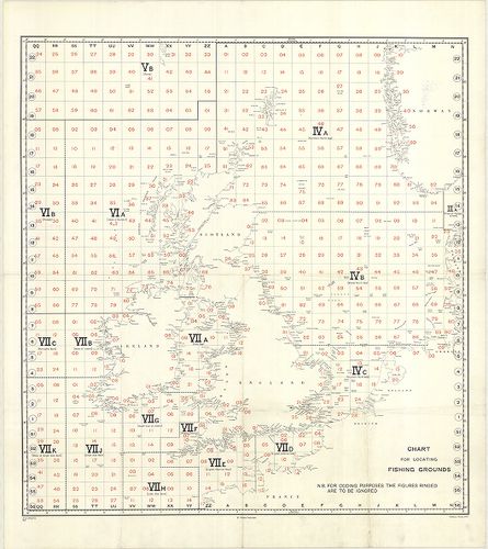
| Title | Chart for locating grounds N. B. for coding purposes the figures ringed are to be ignored. No. A. 208/F. G. 3881 |
| Main title | Nagy-Britannia halászati körzeteinek elhelyezési áttekintő térképe. |
77. Skizze von Grossbritannien mit den British und Narrow Seas. [B VI c 10]
Institute and Museum of Military History •
B VI c
•
B VI Anglia, Skócia és Írország
•
B I–XV. Európa
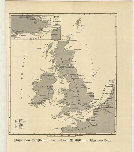
| Title | Skizze von Grossbritannien mit den British und Narrow Seas. |
| Main title | Mt.: Skizze der Narrow Seas. (A La Manche csatorna elhelyezkedése.) |
| Subject | Nagy-Britannia a Brit-tengerekkel és a La Manche csatornával a 19. században. |
78. Foldex Road Map of Great Britain. [B VI c 11]
Institute and Museum of Military History •
B VI c
•
B VI Anglia, Skócia és Írország
•
B I–XV. Európa
| Title | Foldex Road Map of Great Britain. |
| Main title | 8 mt.: 1. London. 2. Cardiff. 3. Manchester. 4. Birmingham. 5. Glasgow. 6. Edinburgh. 7. Dundee. 8. Aberdeen. |
79. South West England and South Wales. 2. Primary routes map. [B VI c 12]
Institute and Museum of Military History •
B VI c
•
B VI Anglia, Skócia és Írország
•
B I–XV. Európa
| Title | South West England and South Wales. 2. Primary routes map. |
80. Great Britain. – Grande Bretagne. – Grossbritannien. – Eire.... [B VI c 13]
Institute and Museum of Military History •
B VI c
•
B VI Anglia, Skócia és Írország
•
B I–XV. Európa
| Title | Great Britain. – Grande Bretagne. – Grossbritannien. – Eire. – Ireland. |
| Main title | 3 mt.: 1. Shetland Islands. (Shetland szigetek.) 2. Orkney Islands. (Orkney szigetek.) 3. [Guernsey és a környező szigetek.] |