1. Facies orbis septentrionalis ad mentem Ptolemaei. A. H. XXXI... [B VI a 2]
Institute and Museum of Military History •
B VI a
•
B VI Anglia, Skócia és Írország
•
B I–XV. Európa
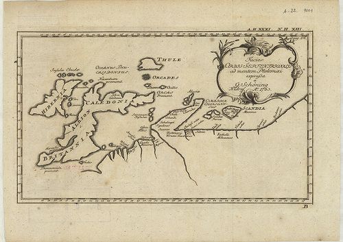
| Title | Facies orbis septentrionalis ad mentem Ptolemaei. A. H. XXXI. N. H. XIII. |
| Main title | Az északi földrész térképe: Nagybritannia és Írország Ptolemaiosz elképzelése szerint. |
2. Tabula novissima accuratissima Regnorum Angliae, Scoatiae, H... [B VI a 7]
Institute and Museum of Military History •
B VI a
•
B VI Anglia, Skócia és Írország
•
B I–XV. Európa
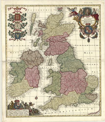
| Title | Tabula novissima accuratissima Regnorum Angliae, Scoatiae, Hibérniae. |
| Main title | Anglia, Skócia és Írország általános térképe a 18. században. |
3. Anglia, Scotia et Hibernia cum Insulis vicinis. [B VI a 8]
Institute and Museum of Military History •
B VI a
•
B VI Anglia, Skócia és Írország
•
B I–XV. Európa
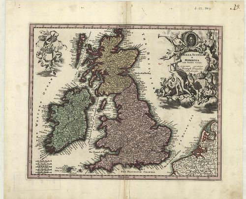
| Title | Anglia, Scotia et Hibernia cum Insulis vicinis. |
| Main title | Anglia, Skócia és Írország általános térképe a 18. században. |
4. Charte der vereinigten Königeriche Grossbritannien und Irlan... [B VI a 9]
Institute and Museum of Military History •
B VI a
•
B VI Anglia, Skócia és Írország
•
B I–XV. Európa
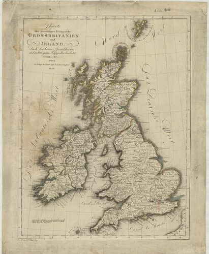
| Title | Charte der vereinigten Königeriche Grossbritannien und Irland. |
| Main title | Nagybritannia és Írország általános térképe 1806-ban. |
5. Die Britischen Inseln und das umliegende Meer. [B VI a 10]
Institute and Museum of Military History •
B VI a
•
B VI Anglia, Skócia és Írország
•
B I–XV. Európa
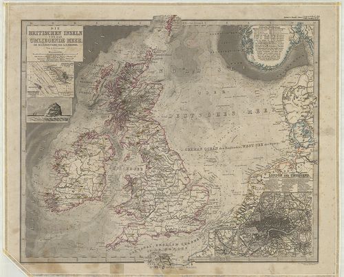
| Title | Die Britischen Inseln und das umliegende Meer. |
| Main title | 3 mt.: 1. Helgoland. |
| Subject | 2. Helgoland und die Düne. |
6. Schlag nach über England. [B VI a 11]
Institute and Museum of Military History •
B VI a
•
B VI Anglia, Skócia és Írország
•
B I–XV. Európa
| Title | Schlag nach über England. |
| Main title | 2 térk.: 1. Grossbritannien und Irland. |
| Subject | (Nagybritannia és Írország.) 2. Politische Karte der Erde. (A világ politikai térképe.) |
7. A General Map of Great Britain and Ireland… – Regnorum Magna... [B VI a 12]
Institute and Museum of Military History •
B VI a
•
B VI Anglia, Skócia és Írország
•
B I–XV. Európa
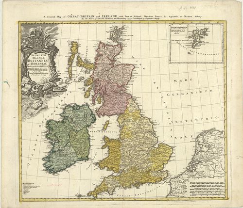
| Title | A General Map of Great Britain and Ireland… – Regnorum Magnae Britanniae et Hiberniae… |
| Main title | Mt.: Insulae Schetlandicae. (Shetland-szk.) |
| Subject | Nagy-Britannia és Írország általános térképe 1749-ben. |
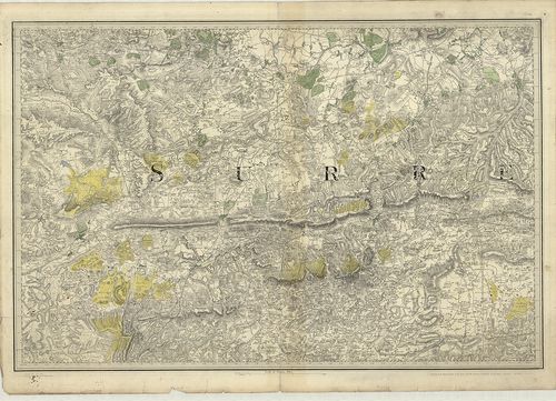
8. British Atlas, Comprising separate maps of every County in E... [B VI a 13/1]
Institute and Museum of Military History •
B VI a
•
B VI Anglia, Skócia és Írország
•
B I–XV. Európa
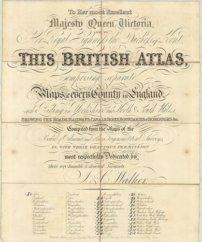
| Title | British Atlas, Comprising separate maps of every County in England… |
| Main title | 1. Northamptonshire. 2. Northumberland. 3. Nottinghamshire. 4. Oxfordshire. 5. Rutlandshire. 6. Shorpshire. 7. Somersetshire. 8. Staffordshire. 9. Suffolk. 10. Surrey. 11. Sussex. 12. Warwickshire. 13. Wiltshire. 14. Yorkshire, West Riding. 15. Yorkshire, North Riding. 16. Wales, North West. 17. Wales, North-East. 18. Wales, South-West. 19. Wales, South-East.Anglia grófságainak általános térképe 1837-ben. |
9. Cary’s Traveller’s companion or, a Delineation of the Turnpi... [B VI a 13/2]
Institute and Museum of Military History •
B VI a
•
B VI Anglia, Skócia és Írország
•
B I–XV. Európa
| Title | Cary’s Traveller’s companion or, a Delineation of the Turnpike Roads of England and Wales … |
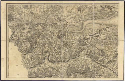
10. Index shewing the progress of the ordnance survey of the Sou... [B VI a 14]
Institute and Museum of Military History •
B VI a
•
B VI Anglia, Skócia és Írország
•
B I–XV. Európa
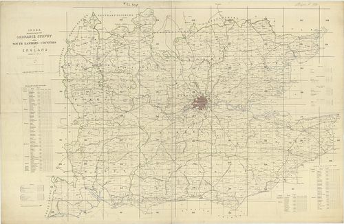
| Title | Index shewing the progress of the ordnance survey of the South Eastern Counties of England. |
| Main title | Anglia DK-i grófságainak katonai térképe. |
11. Anglia Skotzia és Irlandia földképe. [B VI a 15]
Institute and Museum of Military History •
B VI a
•
B VI Anglia, Skócia és Írország
•
B I–XV. Európa
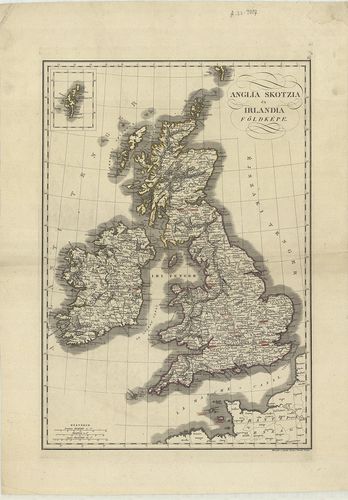
| Title | Anglia Skotzia és Irlandia földképe. |
| Main title | Anglia, Skócia és Írország térképe 1840 körül. |
12. Karte von Grossbritannien und Ireland. X. [B VI a 16]
Institute and Museum of Military History •
B VI a
•
B VI Anglia, Skócia és Írország
•
B I–XV. Európa
| Title | Karte von Grossbritannien und Ireland. X. |
| Main title | Nagy-Britannia és Írország általános térképe 1795-ben. |
13. Das Königreich England. XI. [B VI a 17]
Institute and Museum of Military History •
B VI a
•
B VI Anglia, Skócia és Írország
•
B I–XV. Európa
| Title | Das Königreich England. XI. |
| Main title | Az Angol Királyság térképe 1795-ben. |
14. Karte von Scotland. XII. [B VI a 18]
Institute and Museum of Military History •
B VI a
•
B VI Anglia, Skócia és Írország
•
B I–XV. Európa
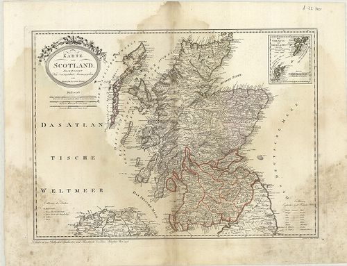
| Title | Karte von Scotland. XII. |
| Main title | Skócia térképe 1795-ben. |
15. Karte von Ireland. XIII. [B VI a 19]
Institute and Museum of Military History •
B VI a
•
B VI Anglia, Skócia és Írország
•
B I–XV. Európa
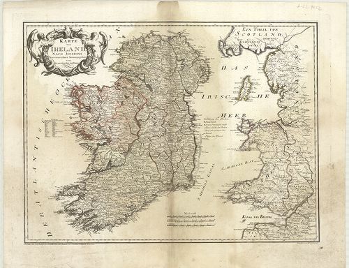
| Title | Karte von Ireland. XIII. |
| Main title | Írország térképe 1795-ben. |
16. Insularum Britannicarum. [B VI a 20]
Institute and Museum of Military History •
B VI a
•
B VI Anglia, Skócia és Írország
•
B I–XV. Európa
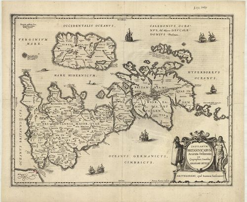
| Title | Insularum Britannicarum. |
| Main title | A Brit-szigetek térképe a XVI. században. |
17. Parte meridionale del Regno D’Inghilterra. [B VI a 21]
Institute and Museum of Military History •
B VI a
•
B VI Anglia, Skócia és Írország
•
B I–XV. Európa
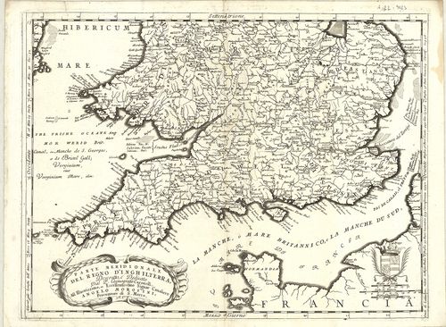
| Title | Parte meridionale del Regno D’Inghilterra. |
| Main title | Az Angol Királyság déli részének térképe 1690 körül. |
18. General Survey of England and Wales. An entirely new and acc... [B VI a 22/3]
Institute and Museum of Military History •
B VI a
•
B VI Anglia, Skócia és Írország
•
B I–XV. Európa
| Title | General Survey of England and Wales. An entirely new and accurate Survey of the County of Kent… |
| Main title | Kent grófság térképe 1801-ben. |
19. Neueste Karte von Grossbritannien und Ireland. [B VI a 25]
Institute and Museum of Military History •
B VI a
•
B VI Anglia, Skócia és Írország
•
B I–XV. Európa
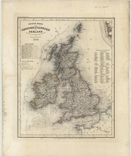
| Title | Neueste Karte von Grossbritannien und Ireland. |
| Main title | Nagy-Britannia és Írország térképe 1844-ben. |
20. Neueste Karte von England. [B VI a 26]
Institute and Museum of Military History •
B VI a
•
B VI Anglia, Skócia és Írország
•
B I–XV. Európa
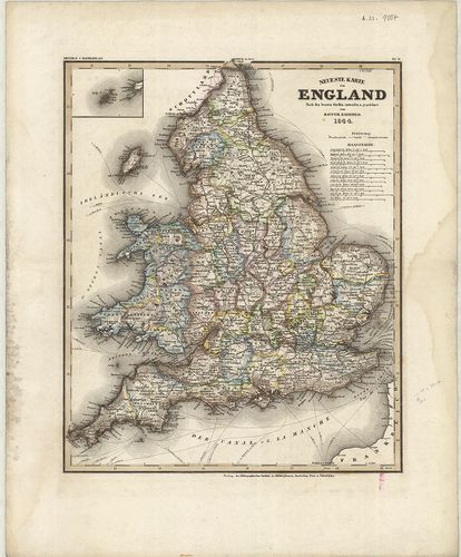
| Title | Neueste Karte von England. |
| Main title | Anglia térképe 1844-ben. |
21. Neueste Karte von Schotland. [B VI a 27]
Institute and Museum of Military History •
B VI a
•
B VI Anglia, Skócia és Írország
•
B I–XV. Európa
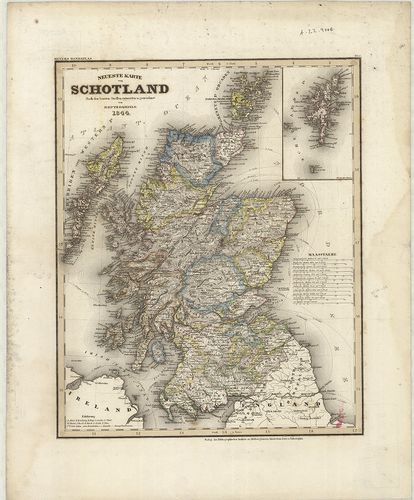
| Title | Neueste Karte von Schotland. |
| Main title | Skócia térképe 1844-ben. |
22. Neuestes Karte von Ireland. [B VI a 28]
Institute and Museum of Military History •
B VI a
•
B VI Anglia, Skócia és Írország
•
B I–XV. Európa
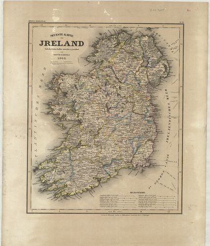
| Title | Neuestes Karte von Ireland. |
| Main title | Írország térképe 1844-ben. |
23. Map of Scotland. [B VI a 30]
Institute and Museum of Military History •
B VI a
•
B VI Anglia, Skócia és Írország
•
B I–XV. Európa
| Title | Map of Scotland. |
| Main title | Skócia térképe 1810-ben. |
24. Scotland with its Islands. [B VI a 31]
Institute and Museum of Military History •
B VI a
•
B VI Anglia, Skócia és Írország
•
B I–XV. Európa
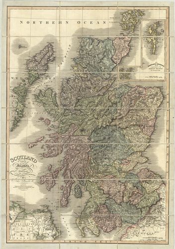
| Title | Scotland with its Islands. |
| Main title | Mt.: The Shetland Islands. (Shetland szk.) |
| Subject | Skócia és szigeteinek térképe 1824-ben. |
25. Grossbritannien und Irland. – Velhagen und Klasings Karte. [B VI a 34]
Institute and Museum of Military History •
B VI a
•
B VI Anglia, Skócia és Írország
•
B I–XV. Európa
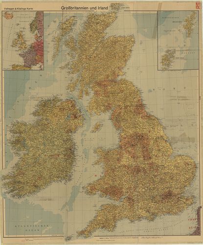
| Title | Grossbritannien und Irland. – Velhagen und Klasings Karte. |
| Main title | Mt.: [Ny-Európa.] A hátoldalon: [Nagy-Britannia gyarmatai.] |
| Subject | Nagy-Britannia és Írország térképe 1940-ben. |
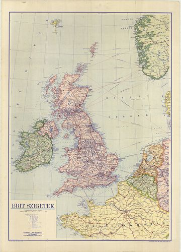
26. [Nagy-Britannia–Írország.] [B VI a 38]
Institute and Museum of Military History •
B VI a
•
B VI Anglia, Skócia és Írország
•
B I–XV. Európa
| Title | [Nagy-Britannia–Írország.] |
27. [Skócia.] [B VI a 38/1]
Institute and Museum of Military History •
B VI a
•
B VI Anglia, Skócia és Írország
•
B I–XV. Európa
| Title | [Skócia.] |
28. Scozia. [B VI a 40]
Institute and Museum of Military History •
B VI a
•
B VI Anglia, Skócia és Írország
•
B I–XV. Európa
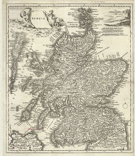
| Title | Scozia. |
| Main title | Skócia térképe a 18. században. |
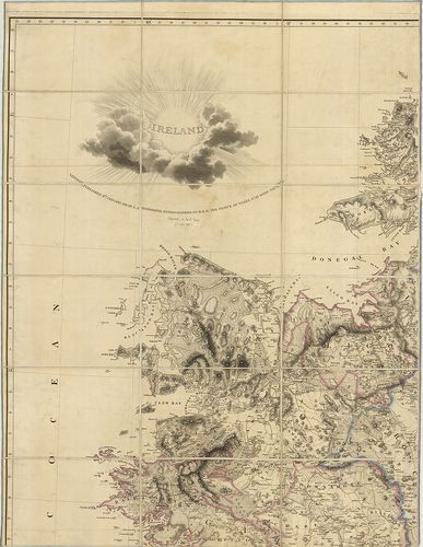
29. Irlanda. [B VI a 41]
Institute and Museum of Military History •
B VI a
•
B VI Anglia, Skócia és Írország
•
B I–XV. Európa
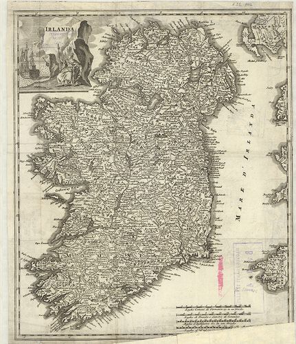
| Title | Irlanda. |
| Main title | Írország térképe a 18. században. |
30. Ireland. [B VI a 42]
Institute and Museum of Military History •
B VI a
•
B VI Anglia, Skócia és Írország
•
B I–XV. Európa
| Title | Ireland. |
| Main title | Írország térképe 1811-ben. |
31. Ireland. [B VI a 45]
Institute and Museum of Military History •
B VI a
•
B VI Anglia, Skócia és Írország
•
B I–XV. Európa
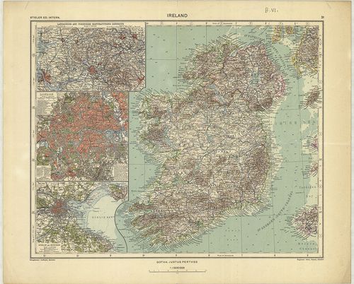
| Title | Ireland. |
| Main title | 3 mt. 1. Lancashire and Yorkshire Manufacturing. (Lancashire és Yorkshire ipari körzetei.) 2. London. 3. Dublin and Suburs. (Dublin és külvárosa.) |
| Subject | Írország térképe 1935-ben. |
32. Regionis qvae est circa Londinvm. – Ausführliche Geographisc... [B VI a 46]
Institute and Museum of Military History •
B VI a
•
B VI Anglia, Skócia és Írország
•
B I–XV. Európa
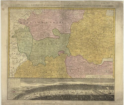
| Title | Regionis qvae est circa Londinvm. – Ausführliche Geographische Vorstellung der Gegend um London. |
| Main title | London és környékének térképe 1742-ben. |
33. Mogg’s New Map of England and Wales with part of Scotland. [B VI a 48]
Institute and Museum of Military History •
B VI a
•
B VI Anglia, Skócia és Írország
•
B I–XV. Európa
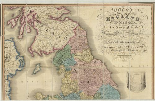
| Title | Mogg’s New Map of England and Wales with part of Scotland. |
| Main title | Anglia, Wales és Skócia egy részének térképe 1823-ban. |
34. Velikobritanija i Irlandszkaja Reszpublika. [B VI a 51]
Institute and Museum of Military History •
B VI a
•
B VI Anglia, Skócia és Írország
•
B I–XV. Európa
| Title | Velikobritanija i Irlandszkaja Reszpublika. |
35. Brit-szigetek. [B VI a 52]
Institute and Museum of Military History •
B VI a
•
B VI Anglia, Skócia és Írország
•
B I–XV. Európa
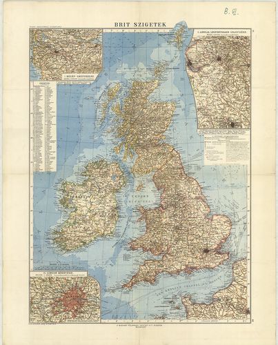
| Title | Brit-szigetek. |
| Main title | 3 mt. 1. Közép-Skótország. 2. Anglia legfontosabb iparvidéke. 3. London környéke. |
36. Brit-szigetek. [B VI a 53]
Institute and Museum of Military History •
B VI a
•
B VI Anglia, Skócia és Írország
•
B I–XV. Európa
| Title | Brit-szigetek. |
37. Nagybritannia és Írország. [B VI a 54]
Institute and Museum of Military History •
B VI a
•
B VI Anglia, Skócia és Írország
•
B I–XV. Európa
| Title | Nagybritannia és Írország. |
38. Grossbritannien und Irland. – Great Britain and Ireland. Fle... [B VI a 55]
Institute and Museum of Military History •
B VI a
•
B VI Anglia, Skócia és Írország
•
B I–XV. Európa
| Title | Grossbritannien und Irland. – Great Britain and Ireland. Flemmings Generalkarte Nr. 14. |
| Main title | 6 mt.: 1. Höhen- und Tiefenschichten. (Hipszometrikus térk.) 2. Geolog. Formationen. (Geológiai térk.) 3. Niederschläge – Isothermen. (Hőmérséklet – csapadék.) 4. Nutzplanzen, Viehzucht und Küstenfischerei. (Növényzet, állattenyésztés, halászat.) 5. Bodenschätze und Industrien. (Ásványi és ipari térk.) 6. Das Britische Weltreich. (A Brit világbirodalom.) |
39. Scotland. [B VI a 56]
Institute and Museum of Military History •
B VI a
•
B VI Anglia, Skócia és Írország
•
B I–XV. Európa
| Title | Scotland. |
40. Index to the Ordnance Survey of Yorkshire. [B VI a 61]
Institute and Museum of Military History •
B VI a
•
B VI Anglia, Skócia és Írország
•
B I–XV. Európa
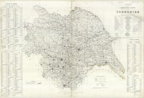
| Title | Index to the Ordnance Survey of Yorkshire. |
| Main title | Yorkshire topográfiai térképeinek áttekintő és csatlakozó térképlapjai 1854–56-ban. |
41. Department of Employment and Productivity Local Offices Area... [B VI a 62]
Institute and Museum of Military History •
B VI a
•
B VI Anglia, Skócia és Írország
•
B I–XV. Európa
| Title | Department of Employment and Productivity Local Offices Areas. – Map of Great Britain. |
| Main title | Mt.: Greater London. |
| Subject | Nagy-Britannia déli részének kerületi beosztása. |
42. The Border – Administrative Areas Edition. [B VI a 63]
Institute and Museum of Military History •
B VI a
•
B VI Anglia, Skócia és Írország
•
B I–XV. Európa
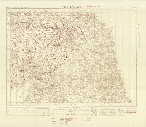
| Title | The Border – Administrative Areas Edition. |
| Main title | Közép-Anglia közigazgatási térképe, autóutakkal 1950-ből. |
43. Index to the Ordnance Survey of the County of Durham. [B VI a 64]
Institute and Museum of Military History •
B VI a
•
B VI Anglia, Skócia és Írország
•
B I–XV. Európa
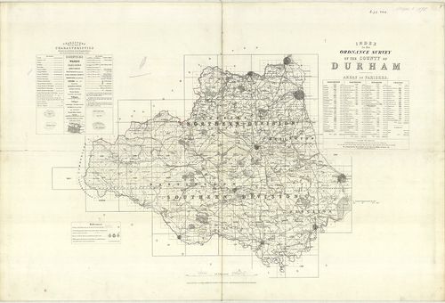
| Title | Index to the Ordnance Survey of the County of Durham. |
| Main title | Durham-grófság topográfiai térképeinek áttekintő lapja 1878-ban. |
44. Bartholomew’s Contoured Road Map of the British Isles. [B VI a 68]
Institute and Museum of Military History •
B VI a
•
B VI Anglia, Skócia és Írország
•
B I–XV. Európa
| Title | Bartholomew’s Contoured Road Map of the British Isles. |
| Main title | 2 mt.: 1. London. 2. System of Road Numbers. (Nagy-Britannia főútvonalai.) |
45. Map of Britain and Northern Ireland. [B VI a 69]
Institute and Museum of Military History •
B VI a
•
B VI Anglia, Skócia és Írország
•
B I–XV. Európa
| Title | Map of Britain and Northern Ireland. |
| Main title | 2 térk.: 1. Central London. 2. Central Edinburgh. |
| Subject | Nagy-Britannia és É-Írország térképe 1960 körül. |
46. Britische Inseln. [B VI a 70]
Institute and Museum of Military History •
B VI a
•
B VI Anglia, Skócia és Írország
•
B I–XV. Európa
| Title | Britische Inseln. |
47. Velká Britanie, Irako a Státy Beneluxu. Soubor Map. „Poznává... [B VI a 71]
Institute and Museum of Military History •
B VI a
•
B VI Anglia, Skócia és Írország
•
B I–XV. Európa
| Title | Velká Britanie, Irako a Státy Beneluxu. Soubor Map. „Poznáváme svét”. |
| Main title | 5 mt.: 1. Politický přehled. (Politikai áttekintő.) 2. Hospodařsky Přehled. (Gazdasági áttekintő.) 3. [Manchester.] 4. [Birmingham.] 5. [London.] |
| Subject | 21 térk.: 1. Tepelné a srazkové poměry. (Hőmérsékleti és csapadék viszonyok.) 2. Lidnatost. 1851. (Népesség 1851-ben.) 3. Lidnatost 1957. (Népesség 1957-ben. 4. Počet sněžných dnů a počátek jara. (A havazás kezdetétől tavaszig.) 5. Rozsah zaledněni v ledových dobách. (Jegesedés terjedése.) 6. Lidnatost 1951. (Népesség 1951-ben.) 7. Jazyky a dialekty. (Nyelv és nyelvjárás.) 8. Půdni typy. (Talajviszonyok.) 9. Kvétena. (Növényzet.) 10. Letecká doprava. (Légi közlekedés.) 11. London. 12. Baile Atha Cliath. (Dublin). 13. Glasgow. 14. Edinburgh. 15. Liverpool. 16. Amsterdam-Haarlem a okoli. 17. Bruxelles Brussel. 18. Luxembourg Luxemburg. 19. Rotterdam. 20. Antwerpen. 21. Atomovy průmysl velké Británie. (Az atomgyártás NBr.-ban.) |
48. Ten-Mile Aviation Map of Great Britain. – Ten Mile Map of Gr... [B VI a 75]
Institute and Museum of Military History •
B VI a
•
B VI Anglia, Skócia és Írország
•
B I–XV. Európa
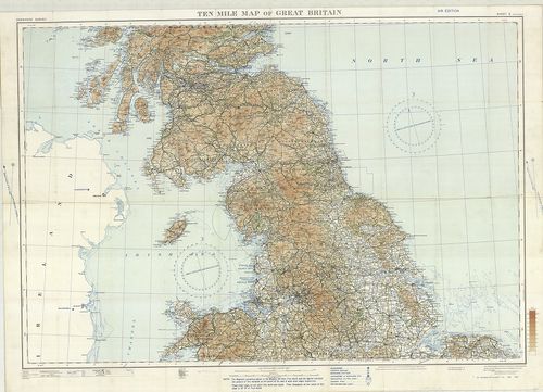
| Title | Ten-Mile Aviation Map of Great Britain. – Ten Mile Map of Great Britain. Sheet 2. |
| Main title | Nagy-Britannia középső részének térképe 1930-ban. |
49. Contoured Road Map of East Kent. – East Kent. Sheet 117. [B VI a 77]
Institute and Museum of Military History •
B VI a
•
B VI Anglia, Skócia és Írország
•
B I–XV. Európa
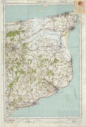
| Title | Contoured Road Map of East Kent. – East Kent. Sheet 117. |
| Main title | Kent-tartomány K-i részének térképe 1928-ban. |
50. Map of Barnard Castle and District. – Barnard Castle and Kir... [B VI a 78]
Institute and Museum of Military History •
B VI a
•
B VI Anglia, Skócia és Írország
•
B I–XV. Európa
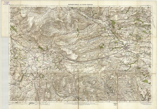
| Title | Map of Barnard Castle and District. – Barnard Castle and Kirk by Stephen. Sheet 14. |
| Main title | Barnard Castle és környékének térképe 1907-ben. |
51. Ordnance Survey „Ten Mile” Map of Great Britain Sheet 2. – R... [B VI a 79]
Institute and Museum of Military History •
B VI a
•
B VI Anglia, Skócia és Írország
•
B I–XV. Európa
| Title | Ordnance Survey „Ten Mile” Map of Great Britain Sheet 2. – Route Planning Map. |
| Main title | 3 mt. 1. [Manchester és környéke.] 2. [Birmingham és környéke.] 3. [London kerületei.] |
| Subject | Nagy-Britannia déli részének általános térképe úthálózattal 1964-ben. |
52. Ordnance Survey „Ten Mile Map of the Great Britain Sheet 1–2... [B VI a 79/1]
Institute and Museum of Military History •
B VI a
•
B VI Anglia, Skócia és Írország
•
B I–XV. Európa
| Title | Ordnance Survey „Ten Mile Map of the Great Britain Sheet 1–2. – Roads. |
| Main title | Mt.: London Area… (London területe.) |
| Subject | Nagy-Britannia térképe úthálózattal 1956-ban. |
53. Map of Great Britain administrative areas north. [B VI a 80]
Institute and Museum of Military History •
B VI a
•
B VI Anglia, Skócia és Írország
•
B I–XV. Európa
| Title | Map of Great Britain administrative areas north. |
| Main title | 3 mt. 1. [Glasgow.] 2. [Edinburgh.] 3. [New Castle – Upon Tyne-Sunderland környéke.] |
| Subject | Nagy-Britannia északi részének közigazgatási térképe. |
54. Map of Great Britain administrative areas north. [B VI a 80/1]
Institute and Museum of Military History •
B VI a
•
B VI Anglia, Skócia és Írország
•
B I–XV. Európa
| Title | Map of Great Britain administrative areas north. |
| Main title | 3 mt.: 1. [Manchester és környéke.] 2. [Birmingham.] 3. [Greater London.] (Nagy London.) |
| Subject | Nagy-Britannia déli részének közigazgatási térképe. |
55. Grossbritannien und Irland. Schulhandkarte. [B VI a 81]
Institute and Museum of Military History •
B VI a
•
B VI Anglia, Skócia és Írország
•
B I–XV. Európa
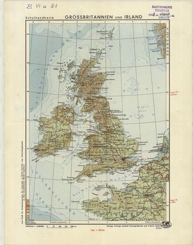
| Title | Grossbritannien und Irland. Schulhandkarte. |
| Main title | Nagy-Britannia és Írország térképe 1950-ben. |
56. Ireland. [B VI a 82]
Institute and Museum of Military History •
B VI a
•
B VI Anglia, Skócia és Írország
•
B I–XV. Európa
| Title | Ireland. |
| Main title | 3 mt.: 1. Dublin, 2. Belfast, 3. Cork. |
| Subject | Írország térképe. |
57. British Isles. [B VI a 83]
Institute and Museum of Military History •
B VI a
•
B VI Anglia, Skócia és Írország
•
B I–XV. Európa
| Title | British Isles. |
| Main title | 1 mt.: Shetland Islands (Zetland). Hátl.: Medieval England. |
58. Nagy Britania vagy is Anglia, Skóczia, Hibernia. [B VI a 84]
Institute and Museum of Military History •
B VI a
•
B VI Anglia, Skócia és Írország
•
B I–XV. Európa
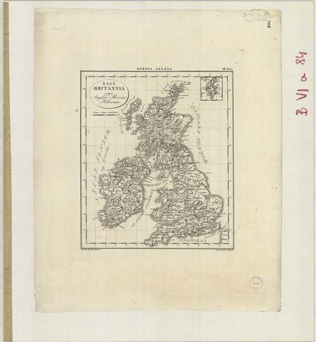
| Title | Nagy Britania vagy is Anglia, Skóczia, Hibernia. |
59. Medieval England. [B VI a 85]
Institute and Museum of Military History •
B VI a
•
B VI Anglia, Skócia és Írország
•
B I–XV. Európa
| Title | Medieval England. |
60. Ireland. [B VI a 86]
Institute and Museum of Military History •
B VI a
•
B VI Anglia, Skócia és Írország
•
B I–XV. Európa
| Title | Ireland. |
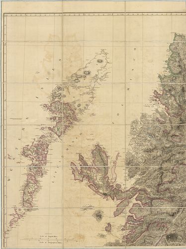
61. A Part of the N. E. – Coast of the Shetland Isles. [B VI b 4]
Institute and Museum of Military History •
B VI b
•
B VI Anglia, Skócia és Írország
•
B I–XV. Európa
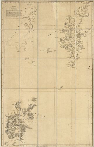
| Title | A Part of the N. E. – Coast of the Shetland Isles. |
| Main title | A Shetland és az Orkney szigetek hegyvízrajzi térképe 1807-ben. |
62. Tavistock and Okehampton. Sheet 137. [B VI b 6]
Institute and Museum of Military History •
B VI b
•
B VI Anglia, Skócia és Írország
•
B I–XV. Európa
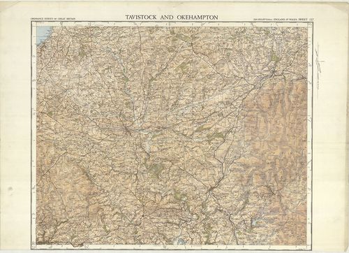
| Title | Tavistock and Okehampton. Sheet 137. |
| Main title | Tavistock és Okehampton környékének topográfiai térképe 1932-ben. |
63. Plymouth. – Physical Features alone. Sheet 144. [B VI b 7]
Institute and Museum of Military History •
B VI b
•
B VI Anglia, Skócia és Írország
•
B I–XV. Európa

| Title | Plymouth. – Physical Features alone. Sheet 144. |
| Main title | Plymouth hegyvízrajzi térképe 1931-ben. |
64. Ordnance Survey of the Isle of Wight and Part of Hampshire. [B VI b 11]
Institute and Museum of Military History •
B VI b
•
B VI Anglia, Skócia és Írország
•
B I–XV. Európa
| Title | Ordnance Survey of the Isle of Wight and Part of Hampshire. |
| Main title | Wight sziget és Hampshire D-i részének topográfiai térképe 1810–1862-ben. |
65. The Irish Channel. Sheet I–II. 1825. A–1825. B. [B VI b 12]
Institute and Museum of Military History •
B VI b
•
B VI Anglia, Skócia és Írország
•
B I–XV. Európa

| Title | The Irish Channel. Sheet I–II. 1825. A–1825. B. |
| Main title | 11 mt.: 1. Belfast Lough. (Belfasti-öböl.) 2. Lough Larne. (Larne-öböl.) 3. Strangford Narrows. (Strangfordi-szoros.) 4. Cambellton Loch. (Cambelltoni öböl.) 5. Lough Carlingford. (Carlingford-öböl.) 6. Kingstown Harbour. (Kingstown kikötő.) 7. Wexford South Bay. (Wexford D-i öböl.) 8. Waterford Harb. (Waterford kikötő.) 9. St. Tudwall Roads. (St. Tudwall-i járatok.) 10. Holyhead Bay. Holyhead öböl.) 11. Milford Haven. (Milford kikötő.) |
| Subject | Az Ír-tenger és az Északi-csatorna partvidékének térképe 1868–1871-ben. |
66. Owers to Christchurch with Spithead and the I. of Wight. 204... [B VI b 13]
Institute and Museum of Military History •
B VI b
•
B VI Anglia, Skócia és Írország
•
B I–XV. Európa
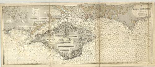
| Title | Owers to Christchurch with Spithead and the I. of Wight. 2045. |
| Main title | Mt.: Continuation of Southampton Water. (Southamptoni víziút.) |
| Subject | A Christchurch-i és Spithead-i öböl partvidékének térképe 1852-ben. |
67. Britannia. [B VI b 15]
Institute and Museum of Military History •
B VI b
•
B VI Anglia, Skócia és Írország
•
B I–XV. Európa
| Title | Britannia. |
| Main title | Anglia hegyvízrajzi térképe 1819-ben. |
68. Angolország hegy és vízrajzi domborművű falitérképe. [B VI b 20]
Institute and Museum of Military History •
B VI b
•
B VI Anglia, Skócia és Írország
•
B I–XV. Európa
| Title | Angolország hegy és vízrajzi domborművű falitérképe. |
69. Britische Inseln. [B VI b 21]
Institute and Museum of Military History •
B VI b
•
B VI Anglia, Skócia és Írország
•
B I–XV. Európa
| Title | Britische Inseln. |
70. Velikobritanija i Irlandija. [B VI b 22]
Institute and Museum of Military History •
B VI b
•
B VI Anglia, Skócia és Írország
•
B I–XV. Európa
| Title | Velikobritanija i Irlandija. |
71. General Post Office Telegraph Map for England and Wales. [B VI c 1]
Institute and Museum of Military History •
B VI c
•
B VI Anglia, Skócia és Írország
•
B I–XV. Európa
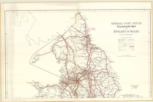
| Title | General Post Office Telegraph Map for England and Wales. |
| Main title | Anglia és Wales postahálózati térképe 1884-ben. |
72. General Post Office Telegraph Map for Ireland. [B VI c 2]
Institute and Museum of Military History •
B VI c
•
B VI Anglia, Skócia és Írország
•
B I–XV. Európa
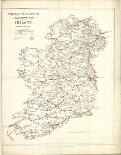
| Title | General Post Office Telegraph Map for Ireland. |
| Main title | Írország postahálózati térképe 1884-ben. |
73. General Post Office Telegraph Map for Scotland. [B VI c 3]
Institute and Museum of Military History •
B VI c
•
B VI Anglia, Skócia és Írország
•
B I–XV. Európa
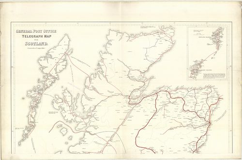
| Title | General Post Office Telegraph Map for Scotland. |
| Main title | Mt.: [Orkney és Shetland szigetek.] |
| Subject | Skócia postahálózati térképe 1884-ben. |
74. Roman Britain. [B VI c 7]
Institute and Museum of Military History •
B VI c
•
B VI Anglia, Skócia és Írország
•
B I–XV. Európa
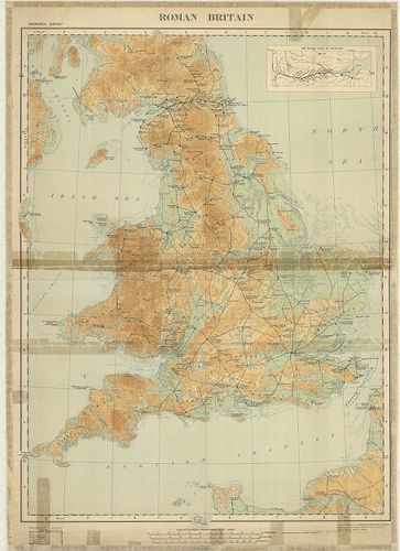
| Title | Roman Britain. |
| Main title | Mt.: The Roman Wall in Scotland. (A római határfal Skóciában.) |
| Subject | Anglia római kori történelmi térképe. |
75. Nagy-Britannia autótérképe. [B VI c 8]
Institute and Museum of Military History •
B VI c
•
B VI Anglia, Skócia és Írország
•
B I–XV. Európa
| Title | Nagy-Britannia autótérképe. |
| Main title | 3 mt.: 1. Channel Islands. |
| Subject | 2. Orkney Islands. |
76. Chart for locating grounds N. B. for coding purposes the fig... [B VI c 9]
Institute and Museum of Military History •
B VI c
•
B VI Anglia, Skócia és Írország
•
B I–XV. Európa
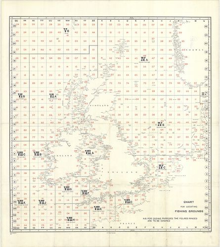
| Title | Chart for locating grounds N. B. for coding purposes the figures ringed are to be ignored. No. A. 208/F. G. 3881 |
| Main title | Nagy-Britannia halászati körzeteinek elhelyezési áttekintő térképe. |
77. Skizze von Grossbritannien mit den British und Narrow Seas. [B VI c 10]
Institute and Museum of Military History •
B VI c
•
B VI Anglia, Skócia és Írország
•
B I–XV. Európa
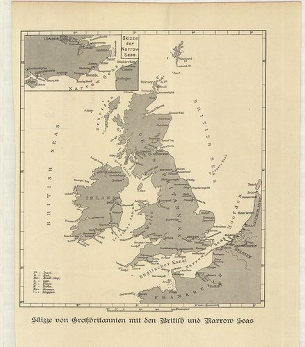
| Title | Skizze von Grossbritannien mit den British und Narrow Seas. |
| Main title | Mt.: Skizze der Narrow Seas. (A La Manche csatorna elhelyezkedése.) |
| Subject | Nagy-Britannia a Brit-tengerekkel és a La Manche csatornával a 19. században. |
78. Foldex Road Map of Great Britain. [B VI c 11]
Institute and Museum of Military History •
B VI c
•
B VI Anglia, Skócia és Írország
•
B I–XV. Európa
| Title | Foldex Road Map of Great Britain. |
| Main title | 8 mt.: 1. London. 2. Cardiff. 3. Manchester. 4. Birmingham. 5. Glasgow. 6. Edinburgh. 7. Dundee. 8. Aberdeen. |
79. South West England and South Wales. 2. Primary routes map. [B VI c 12]
Institute and Museum of Military History •
B VI c
•
B VI Anglia, Skócia és Írország
•
B I–XV. Európa
| Title | South West England and South Wales. 2. Primary routes map. |
80. Great Britain. – Grande Bretagne. – Grossbritannien. – Eire.... [B VI c 13]
Institute and Museum of Military History •
B VI c
•
B VI Anglia, Skócia és Írország
•
B I–XV. Európa
| Title | Great Britain. – Grande Bretagne. – Grossbritannien. – Eire. – Ireland. |
| Main title | 3 mt.: 1. Shetland Islands. (Shetland szigetek.) 2. Orkney Islands. (Orkney szigetek.) 3. [Guernsey és a környező szigetek.] |
81. The Scottish Tourist Board’s Map of Scotland. [B VI c 14]
Institute and Museum of Military History •
B VI c
•
B VI Anglia, Skócia és Írország
•
B I–XV. Európa
| Title | The Scottish Tourist Board’s Map of Scotland. |
82. Great Britain. – Grande Bretagne. – Ireland. – Irlande. – Gr... [B VI c 15]
Institute and Museum of Military History •
B VI c
•
B VI Anglia, Skócia és Írország
•
B I–XV. Európa
| Title | Great Britain. – Grande Bretagne. – Ireland. – Irlande. – Gr.[oss] Britannien. – Irland. Shell Reisekarte. |
| Main title | 5 mt.: 1. London. 2. [London és környéke.] 3. [Közép-Anglia.] 4. [A Cronwall-félsziget.] 5. Shetland Islands. (Shetland szigetek.) |
83. Johnston’s Basic Motoring Atlas of Great Britain and Ireland... [B VI c 16]
Institute and Museum of Military History •
B VI c
•
B VI Anglia, Skócia és Írország
•
B I–XV. Európa
| Title | Johnston’s Basic Motoring Atlas of Great Britain and Ireland. |
| Main title | 32 mt. városok áthajtási térképei: 1. Liverpool. 2. Manchester. 3. Birmingham. 4. Leeds. 5. Sheffield. 6. Nottingham. 7. Bristol. 8. Bath. 9. Darlington. 10. Doncaster. 11. Preston. 12. Berwick on Tweed. 13. Wolherhampton. 14. Leicester. 15. Chester. 16. Derby. 17. Cardiff. 18. Gloucester. 19. York. 20. Hull. 21. Exeter. 22. Salisbury. 23. Cambrdige. 24. Oxford. 25. Shrewsbury. 26. Worchester. 27. Newcastle-upon Tyne. 28. Carlisle. 29. Glasgow. 30. Edinburgh. 31. Belfast. 32. Dublin. |
84. Planning Map of Great Britain. [B VI c 17]
Institute and Museum of Military History •
B VI c
•
B VI Anglia, Skócia és Írország
•
B I–XV. Európa
| Title | Planning Map of Great Britain. |
85. Road Maps. National Benzole. [B VI c 18]
Institute and Museum of Military History •
B VI c
•
B VI Anglia, Skócia és Írország
•
B I–XV. Európa
| Title | Road Maps. National Benzole. |
| Main title | 1. South West England–South East England. (DNy- és DK-Anglia.) 2. The Midlands–Eastern England–Wales. (Közép- és K-Anglia és Wales.) 3. Northern England–Southern Scotland. (É-Anglia és D-Skócia.) 4. Central Scotland–Northern Scotland. (Közép- és É-Skócia.) 5. Central and Greater London. |
| Subject | (London: Belváros és környéke.) |
86. Road Map Great Britain and Ireland with Western Europe and a... [B VI c 19]
Institute and Museum of Military History •
B VI c
•
B VI Anglia, Skócia és Írország
•
B I–XV. Európa
| Title | Road Map Great Britain and Ireland with Western Europe and adjacent North Africa. Esso. |
| Main title | 1. Great Britain and Ireland. |
| Subject | 2. Western Europe and adjacent North Africa. |
87. Britain a Map for Tourist. – Map of Britain and Northern Ire... [B VI c 20]
Institute and Museum of Military History •
B VI c
•
B VI Anglia, Skócia és Írország
•
B I–XV. Európa
| Title | Britain a Map for Tourist. – Map of Britain and Northern Ireland. |
| Main title | Mt.: Internal Air Route. (Belföldi légi utak.) |
| Subject | 1. Central London. 2. Central Edinburgh. |
88. Gulf Road Map of Great Britain. [B VI c 21]
Institute and Museum of Military History •
B VI c
•
B VI Anglia, Skócia és Írország
•
B I–XV. Európa
| Title | Gulf Road Map of Great Britain. |
89. Reisekarte Britische Inseln. [B VI c 22]
Institute and Museum of Military History •
B VI c
•
B VI Anglia, Skócia és Írország
•
B I–XV. Európa
| Title | Reisekarte Britische Inseln. |
90. Passenger Services Timetable. – British Railways Southern Re... [B VI c 23]
Institute and Museum of Military History •
B VI c
•
B VI Anglia, Skócia és Írország
•
B I–XV. Európa
| Title | Passenger Services Timetable. – British Railways Southern Region. |
| Main title | 1 térk. mell.: British Railways Southern Region. |
91. Great Britain–Ireland. Carte Automobile „GB” Hallwag. [B VI c 24]
Institute and Museum of Military History •
B VI c
•
B VI Anglia, Skócia és Írország
•
B I–XV. Európa
| Title | Great Britain–Ireland. Carte Automobile „GB” Hallwag. |
92. The British Isles–England. – Scotland – Ireland and Wales Of... [B VI c 25]
Institute and Museum of Military History •
B VI c
•
B VI Anglia, Skócia és Írország
•
B I–XV. Európa
| Title | The British Isles–England. – Scotland – Ireland and Wales Officially known as The United Kingdom of Great Britain and Northern Ireland and The Republic of Ireland. |
| Main title | A Brit-szigetek: Anglia, Skócia, Írország és Wales térképe 1949-ben. |
93. Shakespeare’s Britain, Based on John Spead’s map, The Kingdo... [B VI c 26]
Institute and Museum of Military History •
B VI c
•
B VI Anglia, Skócia és Írország
•
B I–XV. Európa
| Title | Shakespeare’s Britain, Based on John Spead’s map, The Kingdome of Great Britaine and Ireland, from bis 1611. |
| Main title | 2 mt.: 1. London. (madártávlatos képe.) 2. Stratford upon Auern. |
| Subject | A Shakespeare-korabeli Nagy-Britannia térképe. |
94. Armada Maps. Bartholomew. [B VI c 27]
Institute and Museum of Military History •
B VI c
•
B VI Anglia, Skócia és Írország
•
B I–XV. Európa
| Title | Armada Maps. Bartholomew. |
| Main title | Hátl.: The Armada. térk. |
95. Clan Map. ’Scotland of old’ Bartholomews. [B VI c 28]
Institute and Museum of Military History •
B VI c
•
B VI Anglia, Skócia és Írország
•
B I–XV. Európa
| Title | Clan Map. ’Scotland of old’ Bartholomews. |
96. GT map of Britain Bartholomew-West Country-Sheet 1. [B VI c 29]
Institute and Museum of Military History •
B VI c
•
B VI Anglia, Skócia és Írország
•
B I–XV. Európa
| Title | GT map of Britain Bartholomew-West Country-Sheet 1. |
97. Velikobritanija i Irlandija. Ekonomicseszkaja ucsebnaja kart... [B VI c 30]
Institute and Museum of Military History •
B VI c
•
B VI Anglia, Skócia és Írország
•
B I–XV. Európa
| Title | Velikobritanija i Irlandija. Ekonomicseszkaja ucsebnaja karta. |
98. Velikobritanija i Ejre. Ucsebna ikonomicseszka karta. [B VI c 31]
Institute and Museum of Military History •
B VI c
•
B VI Anglia, Skócia és Írország
•
B I–XV. Európa
| Title | Velikobritanija i Ejre. Ucsebna ikonomicseszka karta. |
99. The gas council. Natural gas transmission system. [B VI c 32]
Institute and Museum of Military History •
B VI c
•
B VI Anglia, Skócia és Írország
•
B I–XV. Európa
| Title | The gas council. Natural gas transmission system. |
100. The gas council. National gas distribution system. [B VI c 32/1]
Institute and Museum of Military History •
B VI c
•
B VI Anglia, Skócia és Írország
•
B I–XV. Európa
| Title | The gas council. National gas distribution system. |