321. Polska. Przegladova mapa użytkowania ziemi. [B XI c 258]
Institute and Museum of Military History •
B XI c
•
B XI Oroszország
•
B I–XV. Európa
| Title | Polska. Przegladova mapa użytkowania ziemi. |
| Main title | 1. Osadnictwo. (Település.) 2. Ziemia orna. (Szántóföld.) 3. Łaki pastwiska. (Legelő.) 4. Łaki pastwiska – Ziemia orna. 5. Ziemia orna – Osadnictwo.Lengyelország földhasznosítási térképe. |
322. Roszszija sz konca XVII v do 60-h godov XVIII v. [B XI c 259]
Institute and Museum of Military History •
B XI c
•
B XI Oroszország
•
B I–XV. Európa
| Title | Roszszija sz konca XVII v do 60-h godov XVIII v. |
| Main title | 2 mt.: 1. [Az Orosz Birodalom területszerzése Ázsiában.] 2. Poltavszkoe szrazsenie 27. VI 1709 g. (A poltavai ütközet 1709. VI. 27-én, a svédekkel.)Oroszország a XVII. sz. 60-as éveitől a XVIII. sz. elejéig. |
323. Kavkaz-turisztszkaja szhema. [B XI c 260]
Institute and Museum of Military History •
B XI c
•
B XI Oroszország
•
B I–XV. Európa
| Title | Kavkaz-turisztszkaja szhema. |
| Main title | 1 mt.: Kavkaz. |
324. Armjanszkaja SzSzR-turisztszkaja szhema. [B XI c 261]
Institute and Museum of Military History •
B XI c
•
B XI Oroszország
•
B I–XV. Európa
| Title | Armjanszkaja SzSzR-turisztszkaja szhema. |
325. Okolice Rzeszowa. [B XI c 262]
Institute and Museum of Military History •
B XI c
•
B XI Oroszország
•
B I–XV. Európa
| Title | Okolice Rzeszowa. |
| Main title | 2 mt.: 1. Plaskowyz Kolbuszowski. |
| Subject | 2. Pogorze Dynowskie. |
326. Góry kaczawskie – Mapa turystyczna. [B XI c 263]
Institute and Museum of Military History •
B XI c
•
B XI Oroszország
•
B I–XV. Európa
| Title | Góry kaczawskie – Mapa turystyczna. |
| Main title | A Kazawskie hegység turistatérképe. |
327. Mapa województw Katowickiego i Opolskiego. [B XI c 264]
Institute and Museum of Military History •
B XI c
•
B XI Oroszország
•
B I–XV. Európa
| Title | Mapa województw Katowickiego i Opolskiego. |
| Main title | 2 mt.: 1. Katowice 2. Plan miasta Opola (Belváros.) |
| Subject | Katowice és Opole vajdaságok térképe. |
328. Dislokation der Truppen und Anstalten im Gouvernementbereich... [B XI c 265]
Institute and Museum of Military History •
B XI c
•
B XI Oroszország
•
B I–XV. Európa
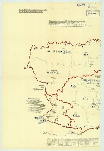
| Title | Dislokation der Truppen und Anstalten im Gouvernementbereiche. |
| Main title | A csapatok és intézmények diszlokációja. |
329. Soviet Union. [B XI c 266]
Institute and Museum of Military History •
B XI c
•
B XI Oroszország
•
B I–XV. Európa
| Title | Soviet Union. |
| Main title | hátl.: Peoples of the Soviet Union (Szovjetunió nemzetiségeinek térképe) színes rajz. |
| Subject | Szovjetunió politikai térképe „The National Geographic Magazine” melléklete. |
330. Westrussland. [B XI c 267]
Institute and Museum of Military History •
B XI c
•
B XI Oroszország
•
B I–XV. Európa
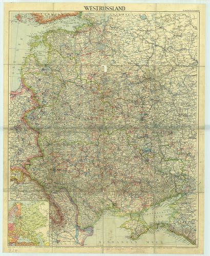
| Title | Westrussland. |
| Main title | 1 mt.: Európai Oroszország.Nyugat-Oroszország térképe. |
331. Etnographisch-geographische Karte des Nördlichen Ural Gebiet... [B XI c 268]
Institute and Museum of Military History •
B XI c
•
B XI Oroszország
•
B I–XV. Európa
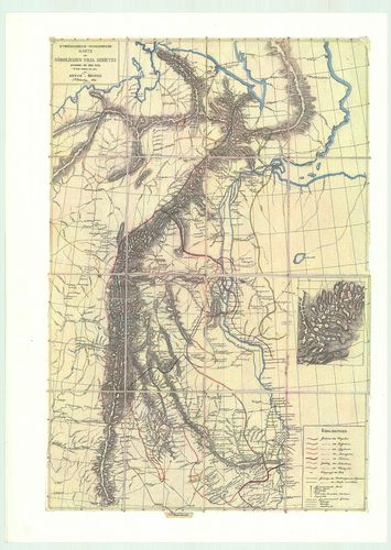
| Title | Etnographisch-geographische Karte des Nördlichen Ural Gebietes |
| Main title | Az Észak-Ural néprajzi és földrajzi térképe. |
332. Karten zum Kriege gegen Russland. (Borítócím.) 3 tl.: (1 főt... [B XI c 269]
Institute and Museum of Military History •
B XI c
•
B XI Oroszország
•
B I–XV. Európa
| Title | Karten zum Kriege gegen Russland. (Borítócím.) 3 tl.: (1 főtérkép, 6 mt.) I. főtérk. Deutsch–Österreichisch–Russische Grenzlande. |
| Main title | [Német–osztrák–orosz határvidék.] Mt.: 1. Karpatenland (Ostgalizien und Bukowina.) |
| Subject | (Kárpátok, K-Galizia és Bukovina) 2. Westpolen. |
333. [Odessa, (Odessza) térségének hajózási és vasútvonalai.] [B XI c 270]
Institute and Museum of Military History •
B XI c
•
B XI Oroszország
•
B I–XV. Európa
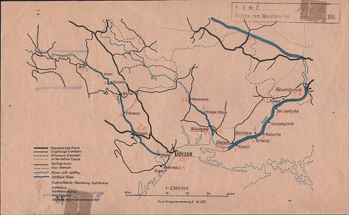
| Title | [Odessa, (Odessza) térségének hajózási és vasútvonalai.] |
334. Eisenbahnkarte v.[on] Russland u.[nd] Ukraine. Aufgelegt im ... [B XI c 271]
Institute and Museum of Military History •
B XI c
•
B XI Oroszország
•
B I–XV. Európa
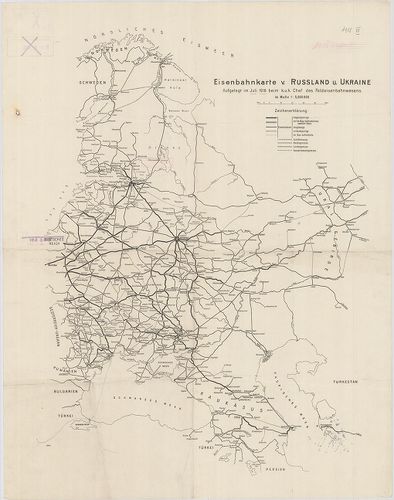
| Title | Eisenbahnkarte v.[on] Russland u.[nd] Ukraine. Aufgelegt im Juli 1918. beim K. u. k. Chef des Feldeisenbahnwesens. |
| Main title | Oroszország és Ukrajna vasúti térképe, Norvégia-Perzsia (Irán) Keleti-tenger–Ural-hegység közötti térségben. |
335. Karta Bachmutszkago uezda, Jekaterinoszalvszkoj gubernii. Sz... [B XI c 272]
Institute and Museum of Military History •
B XI c
•
B XI Oroszország
•
B I–XV. Európa
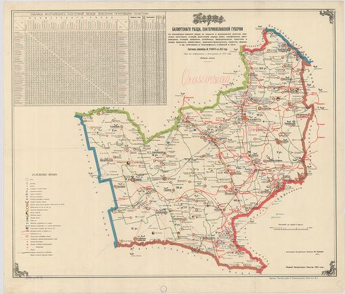
| Title | Karta Bachmutszkago uezda, Jekaterinoszalvszkoj gubernii. Szoszt.: –, 1891. Iszpravl. i dopoln. v. 1915. godu. Izd. 5. |
| Main title | A Bachmuti járás térképe Jekaterinoszlav kormányzóságban. Közigazgatási, iskolai, egyházi, egészségügyi, posta és távirodai, vasúti hálózat. Távolságok jegyz. |
336. Russich–Ponisches Industriegebiet. [B XI c 273]
Institute and Museum of Military History •
B XI c
•
B XI Oroszország
•
B I–XV. Európa
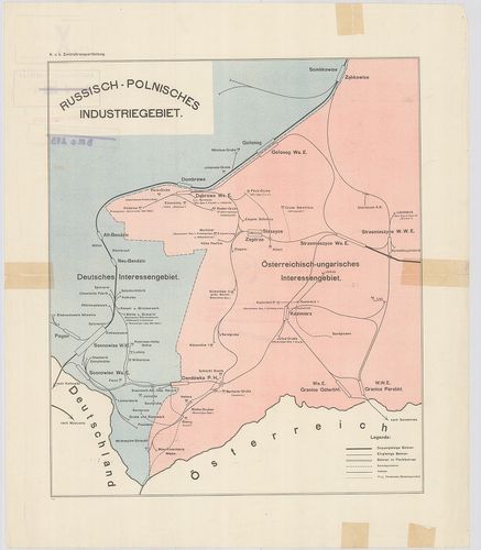
| Title | Russich–Ponisches Industriegebiet. |
| Main title | Az orosz–lengyel iparvidék vázlatos térképe. |
337. Die Ausgestaltung des russischen Eisenbahnnetzes Während des... [B XI c 274]
Institute and Museum of Military History •
B XI c
•
B XI Oroszország
•
B I–XV. Európa
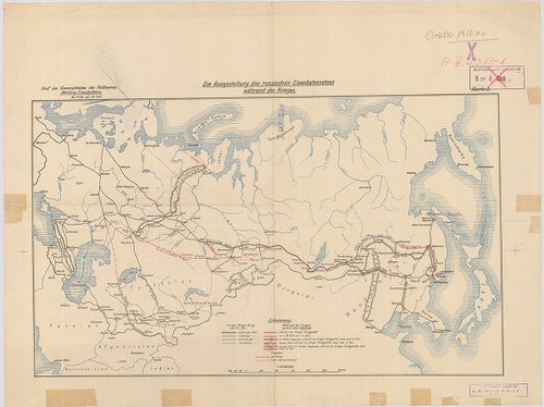
| Title | Die Ausgestaltung des russischen Eisenbahnnetzes Während des Krieges Karte 3. |
| Main title | Az orosz vasúthálózat térképe az első világháború idején. |
338. Das Radiotelegraphennetz Russlands Ende 1911. Beilage 10. [B XI c 275]
Institute and Museum of Military History •
B XI c
•
B XI Oroszország
•
B I–XV. Európa
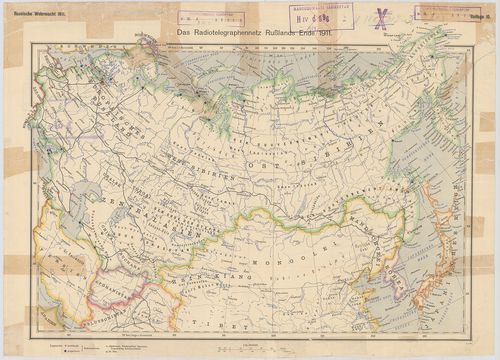
| Title | Das Radiotelegraphennetz Russlands Ende 1911. Beilage 10. |
| Main title | Oroszország rádiótelefon-hálózata 1911 végén. |
339. Südwestrussland. Flemmings Kriegskarte Nr. 41. [B XI c 276]
Institute and Museum of Military History •
B XI c
•
B XI Oroszország
•
B I–XV. Európa
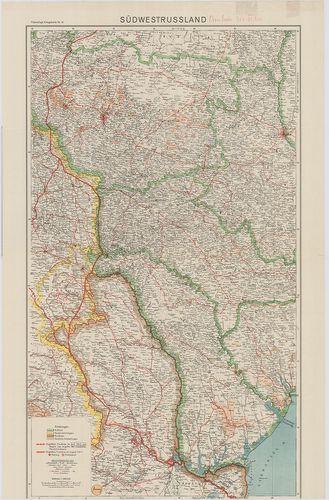
| Title | Südwestrussland. Flemmings Kriegskarte Nr. 41. |
| Main title | Oroszország DNy-i része |
340. Westliches Russland mit den deutschen, österreichisch–ungari... [B XI c 277]
Institute and Museum of Military History •
B XI c
•
B XI Oroszország
•
B I–XV. Európa
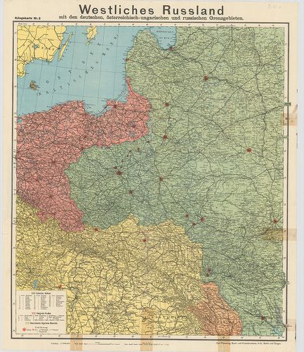
| Title | Westliches Russland mit den deutschen, österreichisch–ungarischen und russischen Grenzgebieten. Kriegskarte Nr. 2. |
| Main title | Oroszország Ny-i része az osztrák–magyar, német és orosz határvidék térképe. |