1. General Post Office Telegraph Map for England and Wales. [B VI c 1]
Institute and Museum of Military History •
B VI c
•
B VI Anglia, Skócia és Írország
•
B I–XV. Európa
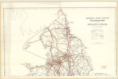
| Title | General Post Office Telegraph Map for England and Wales. |
| Main title | Anglia és Wales postahálózati térképe 1884-ben. |
2. General Post Office Telegraph Map for Ireland. [B VI c 2]
Institute and Museum of Military History •
B VI c
•
B VI Anglia, Skócia és Írország
•
B I–XV. Európa
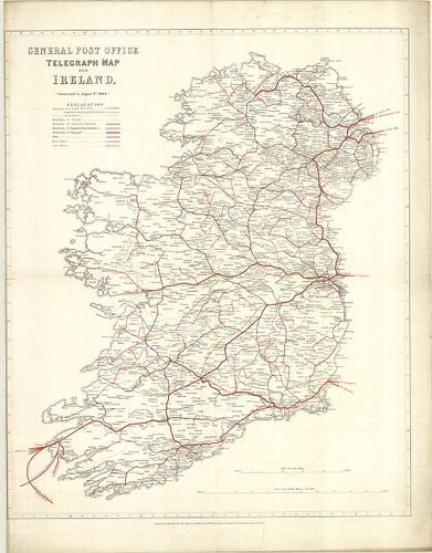
| Title | General Post Office Telegraph Map for Ireland. |
| Main title | Írország postahálózati térképe 1884-ben. |
3. General Post Office Telegraph Map for Scotland. [B VI c 3]
Institute and Museum of Military History •
B VI c
•
B VI Anglia, Skócia és Írország
•
B I–XV. Európa
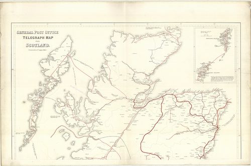
| Title | General Post Office Telegraph Map for Scotland. |
| Main title | Mt.: [Orkney és Shetland szigetek.] |
| Subject | Skócia postahálózati térképe 1884-ben. |
4. Roman Britain. [B VI c 7]
Institute and Museum of Military History •
B VI c
•
B VI Anglia, Skócia és Írország
•
B I–XV. Európa
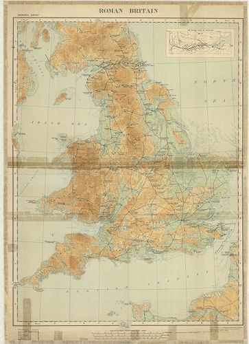
| Title | Roman Britain. |
| Main title | Mt.: The Roman Wall in Scotland. (A római határfal Skóciában.) |
| Subject | Anglia római kori történelmi térképe. |
5. Nagy-Britannia autótérképe. [B VI c 8]
Institute and Museum of Military History •
B VI c
•
B VI Anglia, Skócia és Írország
•
B I–XV. Európa
| Title | Nagy-Britannia autótérképe. |
| Main title | 3 mt.: 1. Channel Islands. |
| Subject | 2. Orkney Islands. |
6. Chart for locating grounds N. B. for coding purposes the fig... [B VI c 9]
Institute and Museum of Military History •
B VI c
•
B VI Anglia, Skócia és Írország
•
B I–XV. Európa
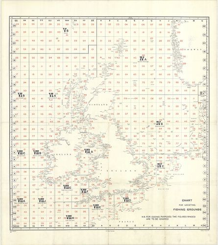
| Title | Chart for locating grounds N. B. for coding purposes the figures ringed are to be ignored. No. A. 208/F. G. 3881 |
| Main title | Nagy-Britannia halászati körzeteinek elhelyezési áttekintő térképe. |
7. Skizze von Grossbritannien mit den British und Narrow Seas. [B VI c 10]
Institute and Museum of Military History •
B VI c
•
B VI Anglia, Skócia és Írország
•
B I–XV. Európa
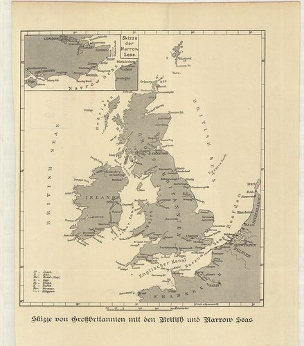
| Title | Skizze von Grossbritannien mit den British und Narrow Seas. |
| Main title | Mt.: Skizze der Narrow Seas. (A La Manche csatorna elhelyezkedése.) |
| Subject | Nagy-Britannia a Brit-tengerekkel és a La Manche csatornával a 19. században. |
8. Foldex Road Map of Great Britain. [B VI c 11]
Institute and Museum of Military History •
B VI c
•
B VI Anglia, Skócia és Írország
•
B I–XV. Európa
| Title | Foldex Road Map of Great Britain. |
| Main title | 8 mt.: 1. London. 2. Cardiff. 3. Manchester. 4. Birmingham. 5. Glasgow. 6. Edinburgh. 7. Dundee. 8. Aberdeen. |
9. South West England and South Wales. 2. Primary routes map. [B VI c 12]
Institute and Museum of Military History •
B VI c
•
B VI Anglia, Skócia és Írország
•
B I–XV. Európa
| Title | South West England and South Wales. 2. Primary routes map. |
10. Great Britain. – Grande Bretagne. – Grossbritannien. – Eire.... [B VI c 13]
Institute and Museum of Military History •
B VI c
•
B VI Anglia, Skócia és Írország
•
B I–XV. Európa
| Title | Great Britain. – Grande Bretagne. – Grossbritannien. – Eire. – Ireland. |
| Main title | 3 mt.: 1. Shetland Islands. (Shetland szigetek.) 2. Orkney Islands. (Orkney szigetek.) 3. [Guernsey és a környező szigetek.] |
11. The Scottish Tourist Board’s Map of Scotland. [B VI c 14]
Institute and Museum of Military History •
B VI c
•
B VI Anglia, Skócia és Írország
•
B I–XV. Európa
| Title | The Scottish Tourist Board’s Map of Scotland. |
12. Great Britain. – Grande Bretagne. – Ireland. – Irlande. – Gr... [B VI c 15]
Institute and Museum of Military History •
B VI c
•
B VI Anglia, Skócia és Írország
•
B I–XV. Európa
| Title | Great Britain. – Grande Bretagne. – Ireland. – Irlande. – Gr.[oss] Britannien. – Irland. Shell Reisekarte. |
| Main title | 5 mt.: 1. London. 2. [London és környéke.] 3. [Közép-Anglia.] 4. [A Cronwall-félsziget.] 5. Shetland Islands. (Shetland szigetek.) |
13. Johnston’s Basic Motoring Atlas of Great Britain and Ireland... [B VI c 16]
Institute and Museum of Military History •
B VI c
•
B VI Anglia, Skócia és Írország
•
B I–XV. Európa
| Title | Johnston’s Basic Motoring Atlas of Great Britain and Ireland. |
| Main title | 32 mt. városok áthajtási térképei: 1. Liverpool. 2. Manchester. 3. Birmingham. 4. Leeds. 5. Sheffield. 6. Nottingham. 7. Bristol. 8. Bath. 9. Darlington. 10. Doncaster. 11. Preston. 12. Berwick on Tweed. 13. Wolherhampton. 14. Leicester. 15. Chester. 16. Derby. 17. Cardiff. 18. Gloucester. 19. York. 20. Hull. 21. Exeter. 22. Salisbury. 23. Cambrdige. 24. Oxford. 25. Shrewsbury. 26. Worchester. 27. Newcastle-upon Tyne. 28. Carlisle. 29. Glasgow. 30. Edinburgh. 31. Belfast. 32. Dublin. |
14. Planning Map of Great Britain. [B VI c 17]
Institute and Museum of Military History •
B VI c
•
B VI Anglia, Skócia és Írország
•
B I–XV. Európa
| Title | Planning Map of Great Britain. |
15. Road Maps. National Benzole. [B VI c 18]
Institute and Museum of Military History •
B VI c
•
B VI Anglia, Skócia és Írország
•
B I–XV. Európa
| Title | Road Maps. National Benzole. |
| Main title | 1. South West England–South East England. (DNy- és DK-Anglia.) 2. The Midlands–Eastern England–Wales. (Közép- és K-Anglia és Wales.) 3. Northern England–Southern Scotland. (É-Anglia és D-Skócia.) 4. Central Scotland–Northern Scotland. (Közép- és É-Skócia.) 5. Central and Greater London. |
| Subject | (London: Belváros és környéke.) |
16. Road Map Great Britain and Ireland with Western Europe and a... [B VI c 19]
Institute and Museum of Military History •
B VI c
•
B VI Anglia, Skócia és Írország
•
B I–XV. Európa
| Title | Road Map Great Britain and Ireland with Western Europe and adjacent North Africa. Esso. |
| Main title | 1. Great Britain and Ireland. |
| Subject | 2. Western Europe and adjacent North Africa. |
17. Britain a Map for Tourist. – Map of Britain and Northern Ire... [B VI c 20]
Institute and Museum of Military History •
B VI c
•
B VI Anglia, Skócia és Írország
•
B I–XV. Európa
| Title | Britain a Map for Tourist. – Map of Britain and Northern Ireland. |
| Main title | Mt.: Internal Air Route. (Belföldi légi utak.) |
| Subject | 1. Central London. 2. Central Edinburgh. |
18. Gulf Road Map of Great Britain. [B VI c 21]
Institute and Museum of Military History •
B VI c
•
B VI Anglia, Skócia és Írország
•
B I–XV. Európa
| Title | Gulf Road Map of Great Britain. |
19. Reisekarte Britische Inseln. [B VI c 22]
Institute and Museum of Military History •
B VI c
•
B VI Anglia, Skócia és Írország
•
B I–XV. Európa
| Title | Reisekarte Britische Inseln. |
20. Passenger Services Timetable. – British Railways Southern Re... [B VI c 23]
Institute and Museum of Military History •
B VI c
•
B VI Anglia, Skócia és Írország
•
B I–XV. Európa
| Title | Passenger Services Timetable. – British Railways Southern Region. |
| Main title | 1 térk. mell.: British Railways Southern Region. |
21. Great Britain–Ireland. Carte Automobile „GB” Hallwag. [B VI c 24]
Institute and Museum of Military History •
B VI c
•
B VI Anglia, Skócia és Írország
•
B I–XV. Európa
| Title | Great Britain–Ireland. Carte Automobile „GB” Hallwag. |
22. The British Isles–England. – Scotland – Ireland and Wales Of... [B VI c 25]
Institute and Museum of Military History •
B VI c
•
B VI Anglia, Skócia és Írország
•
B I–XV. Európa
| Title | The British Isles–England. – Scotland – Ireland and Wales Officially known as The United Kingdom of Great Britain and Northern Ireland and The Republic of Ireland. |
| Main title | A Brit-szigetek: Anglia, Skócia, Írország és Wales térképe 1949-ben. |
23. Shakespeare’s Britain, Based on John Spead’s map, The Kingdo... [B VI c 26]
Institute and Museum of Military History •
B VI c
•
B VI Anglia, Skócia és Írország
•
B I–XV. Európa
| Title | Shakespeare’s Britain, Based on John Spead’s map, The Kingdome of Great Britaine and Ireland, from bis 1611. |
| Main title | 2 mt.: 1. London. (madártávlatos képe.) 2. Stratford upon Auern. |
| Subject | A Shakespeare-korabeli Nagy-Britannia térképe. |
24. Armada Maps. Bartholomew. [B VI c 27]
Institute and Museum of Military History •
B VI c
•
B VI Anglia, Skócia és Írország
•
B I–XV. Európa
| Title | Armada Maps. Bartholomew. |
| Main title | Hátl.: The Armada. térk. |
25. Clan Map. ’Scotland of old’ Bartholomews. [B VI c 28]
Institute and Museum of Military History •
B VI c
•
B VI Anglia, Skócia és Írország
•
B I–XV. Európa
| Title | Clan Map. ’Scotland of old’ Bartholomews. |
26. GT map of Britain Bartholomew-West Country-Sheet 1. [B VI c 29]
Institute and Museum of Military History •
B VI c
•
B VI Anglia, Skócia és Írország
•
B I–XV. Európa
| Title | GT map of Britain Bartholomew-West Country-Sheet 1. |
27. Velikobritanija i Irlandija. Ekonomicseszkaja ucsebnaja kart... [B VI c 30]
Institute and Museum of Military History •
B VI c
•
B VI Anglia, Skócia és Írország
•
B I–XV. Európa
| Title | Velikobritanija i Irlandija. Ekonomicseszkaja ucsebnaja karta. |
28. Velikobritanija i Ejre. Ucsebna ikonomicseszka karta. [B VI c 31]
Institute and Museum of Military History •
B VI c
•
B VI Anglia, Skócia és Írország
•
B I–XV. Európa
| Title | Velikobritanija i Ejre. Ucsebna ikonomicseszka karta. |
29. The gas council. Natural gas transmission system. [B VI c 32]
Institute and Museum of Military History •
B VI c
•
B VI Anglia, Skócia és Írország
•
B I–XV. Európa
| Title | The gas council. Natural gas transmission system. |
30. The gas council. National gas distribution system. [B VI c 32/1]
Institute and Museum of Military History •
B VI c
•
B VI Anglia, Skócia és Írország
•
B I–XV. Európa
| Title | The gas council. National gas distribution system. |
31. Map of Aldershot Command – Ordnance Survey of Eugland and Wa... [B VI c 33]
Institute and Museum of Military History •
B VI c
•
B VI Anglia, Skócia és Írország
•
B I–XV. Európa
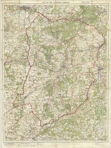
| Title | Map of Aldershot Command – Ordnance Survey of Eugland and Wales – Popular Edition oneinch map. |
| Main title | Aldershot és környéke 1920-ból. |
32. Country Round London. [B VI c 34]
Institute and Museum of Military History •
B VI c
•
B VI Anglia, Skócia és Írország
•
B I–XV. Európa
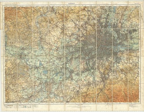
| Title | Country Round London. |
| Main title | London és környéke 1921-ből. |
33. One-Inch Map of England and Wales. – Torquay. England and Wa... [B VI c 35]
Institute and Museum of Military History •
B VI c
•
B VI Anglia, Skócia és Írország
•
B I–XV. Európa
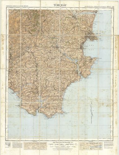
| Title | One-Inch Map of England and Wales. – Torquay. England and Wales. Sheet 145. |
| Main title | Torquay és környéke 1932-ben. |
34. Lake District – Ordnance Survey of Great Britain – tourist m... [B VI c 36]
Institute and Museum of Military History •
B VI c
•
B VI Anglia, Skócia és Írország
•
B I–XV. Európa
| Title | Lake District – Ordnance Survey of Great Britain – tourist map. |
35. Lorn and Lochaber – Ordnance Survey of Great Britain – touri... [B VI c 37]
Institute and Museum of Military History •
B VI c
•
B VI Anglia, Skócia és Írország
•
B I–XV. Európa
| Title | Lorn and Lochaber – Ordnance Survey of Great Britain – tourist map. |
36. Wye Valley and Lower Severn – Ordnance Survey of Great Brita... [B VI c 38]
Institute and Museum of Military History •
B VI c
•
B VI Anglia, Skócia és Írország
•
B I–XV. Európa
| Title | Wye Valley and Lower Severn – Ordnance Survey of Great Britain – tourist map. |
37. Ireland Map. – Bord Fáilte Eireann. – Map of Ireland. [B VI c 41]
Institute and Museum of Military History •
B VI c
•
B VI Anglia, Skócia és Írország
•
B I–XV. Európa
| Title | Ireland Map. – Bord Fáilte Eireann. – Map of Ireland. |
| Main title | Mt.: Basic Routes. (Főútvonalak.) |
| Subject | 1. Dublin. 2. Limerick. 3. Waterford. 4. Cork. 5. Galway-város áthajtási térképek. |
38. A Traveler’s Map of the British Isles. [B VI c 42]
Institute and Museum of Military History •
B VI c
•
B VI Anglia, Skócia és Írország
•
B I–XV. Európa
| Title | A Traveler’s Map of the British Isles. |
| Main title | 4 mt.: 1. Edinburgh 2. Dublin. 3. London. 4. Stratford. |
| Subject | Hátl.: 2 mt.: 1. Roxburgh 2. London és környéke. |
39. Nagy-Britannia és Írország – autótérkép. [B VI c 43]
Institute and Museum of Military History •
B VI c
•
B VI Anglia, Skócia és Írország
•
B I–XV. Európa
| Title | Nagy-Britannia és Írország – autótérkép. |
40. Numbered roads touring map. 2. South-West Counties. 3. Midla... [B VI c 44]
Institute and Museum of Military History •
B VI c
•
B VI Anglia, Skócia és Írország
•
B I–XV. Európa
| Title | Numbered roads touring map. 2. South-West Counties. 3. Midlands and Wales. |
41. Northern England. [B VI c 45]
Institute and Museum of Military History •
B VI c
•
B VI Anglia, Skócia és Írország
•
B I–XV. Európa
| Title | Northern England. |
42. Great Britain and Ireland. [B VI c 46]
Institute and Museum of Military History •
B VI c
•
B VI Anglia, Skócia és Írország
•
B I–XV. Európa
| Title | Great Britain and Ireland. |
43. The Times. Map of Ireland. A detailed map showing counties a... [B VI c 50]
Institute and Museum of Military History •
B VI c
•
B VI Anglia, Skócia és Írország
•
B I–XV. Európa
| Title | The Times. Map of Ireland. A detailed map showing counties and main roads with populations of provinces, counties and major towns. |
44. Ordnance Survey inland waterways. Map of Great Britain. [B VI c 51]
Institute and Museum of Military History •
B VI c
•
B VI Anglia, Skócia és Írország
•
B I–XV. Európa
| Title | Ordnance Survey inland waterways. Map of Great Britain. |
45. Nagy-Britannia. Írország. Autótérkép. [B VI c 52]
Institute and Museum of Military History •
B VI c
•
B VI Anglia, Skócia és Írország
•
B I–XV. Európa
| Title | Nagy-Britannia. Írország. Autótérkép. |
46. Grande Bretagne. [B VI c 53]
Institute and Museum of Military History •
B VI c
•
B VI Anglia, Skócia és Írország
•
B I–XV. Európa
| Title | Grande Bretagne. |
| Main title | Nagy-Britannia autótérképe. |
47. Map of Ireland. [B VI c 54]
Institute and Museum of Military History •
B VI c
•
B VI Anglia, Skócia és Írország
•
B I–XV. Európa
| Title | Map of Ireland. |
| Main title | Írország turistatérképe. |
48. Wales. [B VI c 55]
Institute and Museum of Military History •
B VI c
•
B VI Anglia, Skócia és Írország
•
B I–XV. Európa
| Title | Wales. |