241. Umbria. [B VII a 500]
Institute and Museum of Military History •
B VII a
•
B VII Olaszország
•
B I–XV. Európa
| Title | Umbria. |
242. Umbria. [B VII a 501]
Institute and Museum of Military History •
B VII a
•
B VII Olaszország
•
B I–XV. Európa
| Title | Umbria. |
243. Tirreno Meridionale carta batimetrica. [B VII b 1]
Institute and Museum of Military History •
B VII b
•
B VII Olaszország
•
B I–XV. Európa
| Title | Tirreno Meridionale carta batimetrica. |
| Main title | A Tirrén-tenger batimetrikus térképe 1968. |
244. Mediterraneo – Isola di Sardegna. [B VII b 2]
Institute and Museum of Military History •
B VII b
•
B VII Olaszország
•
B I–XV. Európa
| Title | Mediterraneo – Isola di Sardegna. |
| Main title | Szardínia hajózási térképe. |
245. Hypsometrische Karte von Mittel-Italien. [B VII b 4]
Institute and Museum of Military History •
B VII b
•
B VII Olaszország
•
B I–XV. Európa
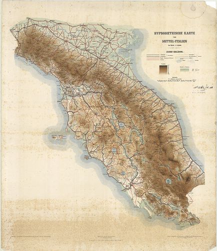
| Title | Hypsometrische Karte von Mittel-Italien. |
| Main title | Közép-Olaszország hipszometrikus térképe 1882 körül. |
246. Carte des Alpes relative á la guerre de 1792. [B VII b 6/1]
Institute and Museum of Military History •
B VII b
•
B VII Olaszország
•
B I–XV. Európa
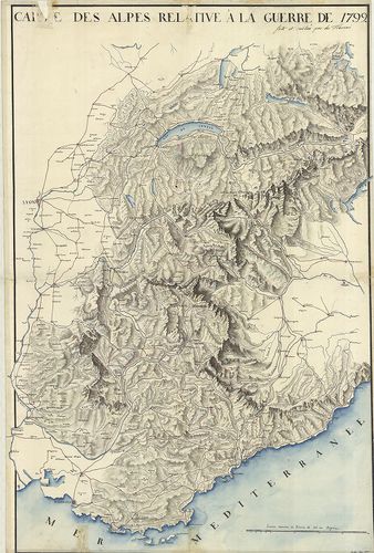
| Title | Carte des Alpes relative á la guerre de 1792. |
| Main title | Az Alpok térképe 1792-ben. |
247. Massif du Mont Blanc extrait des minutes de la Carte de Fran... [B VII b 13]
Institute and Museum of Military History •
B VII b
•
B VII Olaszország
•
B I–XV. Európa
| Title | Massif du Mont Blanc extrait des minutes de la Carte de France. |
| Main title | A Mont Blanc és környékének térképe 1865 körül. |
248. Rundschau von Luschari-Berge. I.–II. Blatt. [B VII b 14]
Institute and Museum of Military History •
B VII b
•
B VII Olaszország
•
B I–XV. Európa

| Title | Rundschau von Luschari-Berge. I.–II. Blatt. |
| Main title | A Luschari-hegy madártávlatos képe 1889-ben. |
249. Carte topographique et militaire du Mont-Cenis et de la nouv... [B VII b 15]
Institute and Museum of Military History •
B VII b
•
B VII Olaszország
•
B I–XV. Európa
| Title | Carte topographique et militaire du Mont-Cenis et de la nouvelle route qui le traverse de Lans-le-Bourg a Suse… |
| Main title | Mont-Cenis és környéke (Bourg St.-Maurice és Susa között.) 1821-ben. |
250. Karte der Marmolatagruppe. [B VII b 16]
Institute and Museum of Military History •
B VII b
•
B VII Olaszország
•
B I–XV. Európa
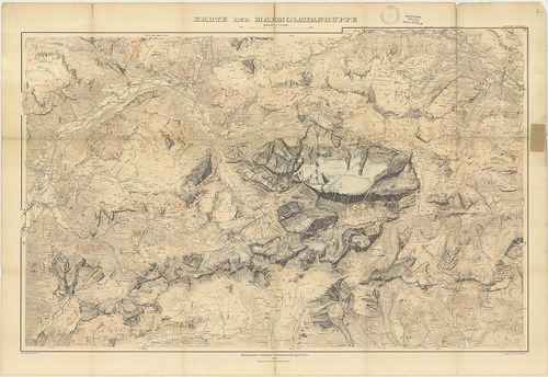
| Title | Karte der Marmolatagruppe. |
| Main title | A Marmolada-hegycsoport térképe 1905-ben. |
251. [Netz-Karte von Mittel-Europa. Süd-West.] [B VII b 18]
Institute and Museum of Military History •
B VII b
•
B VII Olaszország
•
B I–XV. Európa
| Title | [Netz-Karte von Mittel-Europa. Süd-West.] |
| Main title | Észak-Olaszország vízhálózatának térképe 1840 körül. |
252. Riviera da Nervi a Voltri. [B VII b 19]
Institute and Museum of Military History •
B VII b
•
B VII Olaszország
•
B I–XV. Európa
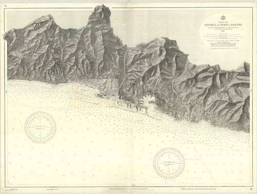
| Title | Riviera da Nervi a Voltri. |
| Main title | Nervi és Voltri közötti partszakasz hajózási térképe. |
253. Gruppo di Brenta. Carte delle zone Turistiche d’Italia. [B VII b 20]
Institute and Museum of Military History •
B VII b
•
B VII Olaszország
•
B I–XV. Európa
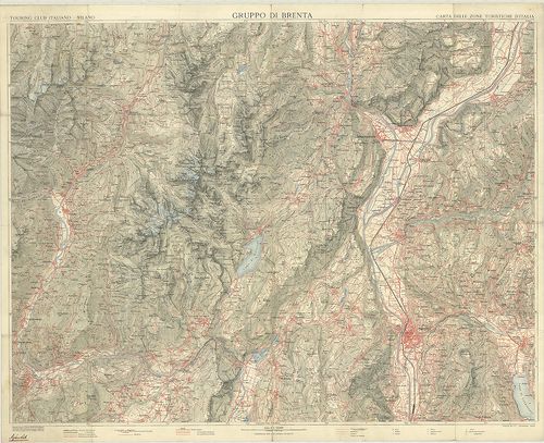
| Title | Gruppo di Brenta. Carte delle zone Turistiche d’Italia. |
| Main title | A Brenta hegycsoport és tágabb környékének térképe az 1920-as években. |
254. Il Vesuvio. [B VII b 27]
Institute and Museum of Military History •
B VII b
•
B VII Olaszország
•
B I–XV. Európa
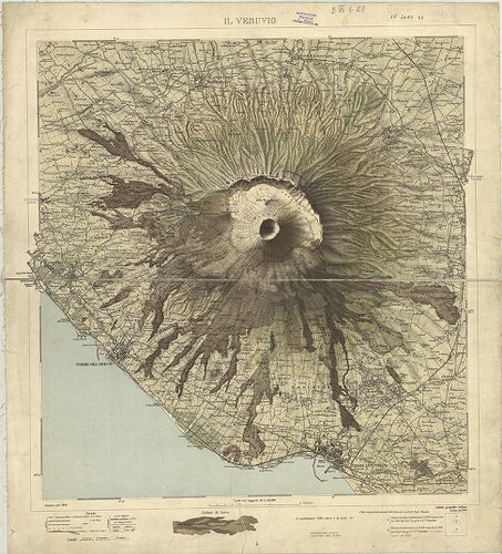
| Title | Il Vesuvio. |
| Main title | A Vezúv és környékének térképe 1908-ban. |
255. Carta Idrografica Stradale Amministrativa Consorziale della ... [B VII b 29]
Institute and Museum of Military History •
B VII b
•
B VII Olaszország
•
B I–XV. Európa
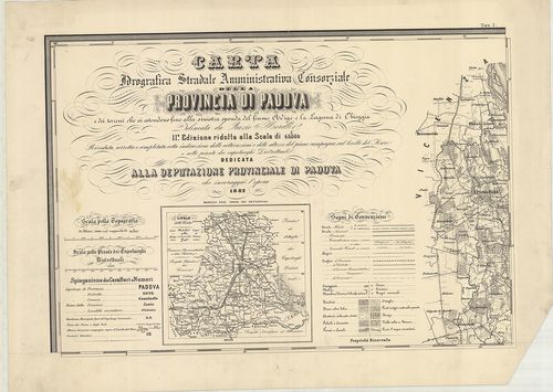
| Title | Carta Idrografica Stradale Amministrativa Consorziale della Provincia di Padova… |
| Main title | 8 mt.: 1. Cittadella. 2. Camposampiero. 3. Monselice. 4. Montagnana. 5. Este. 6. Padova. 7. Conselve. 8. Piove. |
| Subject | Padova tartományvízrajzi, út- és közigazgatási térképe 1882-ben. |
256. Atlante Marittimo del Regno di Napoli… [B VII b 30]
Institute and Museum of Military History •
B VII b
•
B VII Olaszország
•
B I–XV. Európa
| Title | Atlante Marittimo del Regno di Napoli… |
| Main title | A Nápolyi Királyság és Szicília partvidékének térképe 1785-ben. |
257. Icon sinus Baiarum uti nunc videtur… [B VII b 35/10]
Institute and Museum of Military History •
B VII b
•
B VII Olaszország
•
B I–XV. Európa
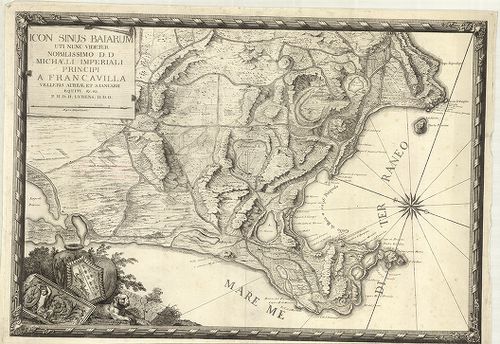
| Title | Icon sinus Baiarum uti nunc videtur… |
| Main title | A Pozzuoli-öböl (Nápolytól Ny-ra) térképe az 1720-as évek körül. |
258. Il Golfo di Spezia. [B VII b 35/12]
Institute and Museum of Military History •
B VII b
•
B VII Olaszország
•
B I–XV. Európa
| Title | Il Golfo di Spezia. |
| Main title | Mt.: Citta e Rada di Viareggio nel Ducato di Lucca. |
| Subject | A Speziai-öböl térképe 1820 körül. |
259. Plan du Golfe de la Spezia Côtes d’ Italia. (Duché de Génes)... [B VII b 35/13]
Institute and Museum of Military History •
B VII b
•
B VII Olaszország
•
B I–XV. Európa
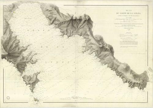
| Title | Plan du Golfe de la Spezia Côtes d’ Italia. (Duché de Génes). |
| Main title | A Speziai-öböl térképe 1846–67-ben. |
260. Laguna Veneta. Mappa topografica. [B VII b 36/2]
Institute and Museum of Military History •
B VII b
•
B VII Olaszország
•
B I–XV. Európa
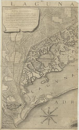
| Title | Laguna Veneta. Mappa topografica. |
| Main title | Mt.: [Venezia.] |
| Subject | A Velence-i laguna topográfiai térképe 1780-ban. |