381. Northern Italy – Southern Italy. [B VII c 239/1]
Institute and Museum of Military History •
B VII c
•
B VII Olaszország
•
B I–XV. Európa
| Title | Northern Italy – Southern Italy. |
| Main title | Olaszország térképe úthálózattal az 1940-es években. |
382. Livellazione geometrica di precisione. [B VII c 240]
Institute and Museum of Military History •
B VII c
•
B VII Olaszország
•
B I–XV. Európa
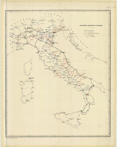
| Title | Livellazione geometrica di precisione. |
| Main title | Olaszország: felsőrendű szintezési vonalak 1924–26-ban. |
383. Livellazione geometrica di precisione. [B VII c 242]
Institute and Museum of Military History •
B VII c
•
B VII Olaszország
•
B I–XV. Európa
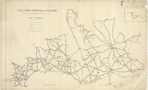
| Title | Livellazione geometrica di precisione. |
| Main title | Mt.: Linea Palazzolo–Chiari–Coccaglio. (Szintezési vonal.) |
| Subject | Felső-Olaszország: Torino és Miláno környékének felsőrendű szintezési vonalai 1930 körül. |
384. [Olaszország pontos geodéziai meghatározása 1900 szeptemberb... [B VII c 243]
Institute and Museum of Military History •
B VII c
•
B VII Olaszország
•
B I–XV. Európa
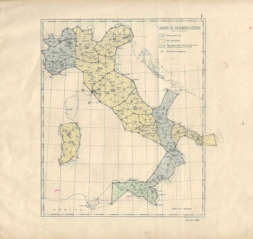
| Title | [Olaszország pontos geodéziai meghatározása 1900 szeptemberben.] |
| Main title | I. Lavori di triangulazione. (Háromszögelési hálózat.) II. Livellazione geometrica di precisione. (Felsőrendű szintezési vonalak.) III. Lavori astronomico-geodetici. (Csillagászati alappontok.) |
385. Rete geodetica Italiana. [B VII c 244]
Institute and Museum of Military History •
B VII c
•
B VII Olaszország
•
B I–XV. Európa
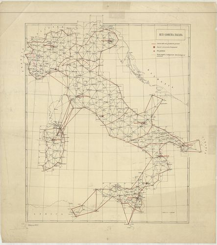
| Title | Rete geodetica Italiana. |
| Main title | Olaszország geodéziai meghatározása 1922-ben. |
386. Carta corografica delle strade comunali obbligatorie d’Itali... [B VII c 245]
Institute and Museum of Military History •
B VII c
•
B VII Olaszország
•
B I–XV. Európa

| Title | Carta corografica delle strade comunali obbligatorie d’Italia. Secondo la legge 30 Agosto 1868. Compartimento di Sardegna. Situazione al 1°. Gennaio 1874. |
| Main title | Az 1868-i törvény alapján megállapított közutak térképe.Szardinia úthálózatának térképe 1874-ben. |
387. Carta Corografica delle strade comunali obbligatorie d’Itali... [B VII c 247]
Institute and Museum of Military History •
B VII c
•
B VII Olaszország
•
B I–XV. Európa
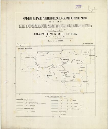
| Title | Carta Corografica delle strade comunali obbligatorie d’Italia. Secondo la Legge 30 Agosto 1868. Compartimento di Sicilia. Situazione al 1° Gennaio 1874. |
| Main title | Az 1868-i törvény alapján megállapított közutak térképe.Szicília úthálózatának térképe 1874-ben. |
388. Carta corografica delle strade comunali obbligatorie d’Itali... [B VII c 248]
Institute and Museum of Military History •
B VII c
•
B VII Olaszország
•
B I–XV. Európa

| Title | Carta corografica delle strade comunali obbligatorie d’Italia. Secondo la Legge 30 Agosto 1868. Compartimento delle Puglie. Situazione al 31 Dicember 1876. |
| Main title | Az 1868-i törvény alapján megállapított közutak térképe.Puglia tartomány úthálózatának térképe 1876-ban. |
389. Carta corografica delle strade comunali obbligatorie d’Itali... [B VII c 249]
Institute and Museum of Military History •
B VII c
•
B VII Olaszország
•
B I–XV. Európa
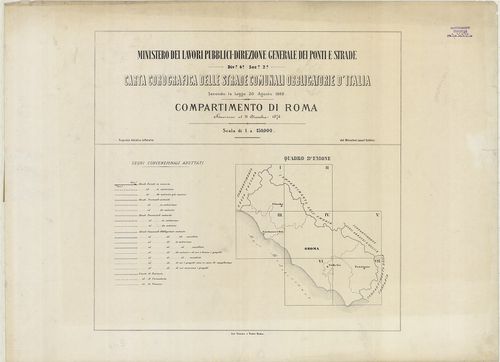
| Title | Carta corografica delle strade comunali obbligatorie d’Italia. Secondo la Legge 30 Agosto 1868. Compartimento di Roma. Situazione al 31 Dicembre 1876. |
| Main title | Az 1868-i törvény alapján megállapított közutak térképe.Róma körzetének úthálózati térképe 1876-ban. |
390. Carta corografica dalle strade comunali obbligatorie d’Itali... [B VII c 250]
Institute and Museum of Military History •
B VII c
•
B VII Olaszország
•
B I–XV. Európa

| Title | Carta corografica dalle strade comunali obbligatorie d’Italia. Secondo la Legge 30 Agosto 1868. Compartimento de Calabria. Situazione al 31 Dicembre 1875. |
| Main title | Az 1868-i törvény alapján megállapított közutak térképe.Calabria tartomány úthálózatának térképe 1875-ben. |
391. Compartimento della Basilicata. [B VII c 251]
Institute and Museum of Military History •
B VII c
•
B VII Olaszország
•
B I–XV. Európa
| Title | Compartimento della Basilicata. |
| Main title | Basilicata tartomány úthálózatának térképe 1875 körül. |
392. Italija. Ekonomicseszkaja ucsebnaja Karta. [B VII c 252]
Institute and Museum of Military History •
B VII c
•
B VII Olaszország
•
B I–XV. Európa
| Title | Italija. Ekonomicseszkaja ucsebnaja Karta. |
| Main title | Olaszország gazdasági térképe középiskolások számára. |
393. Meran und die Dolomiten. – Dr. Brünner’s Dolomiten Auto- und... [B VII c 260]
Institute and Museum of Military History •
B VII c
•
B VII Olaszország
•
B I–XV. Európa
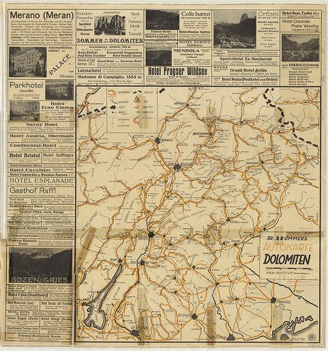
| Title | Meran und die Dolomiten. – Dr. Brünner’s Dolomiten Auto- und Wander-Karte. |
| Main title | 1. Autokarte Dolomiten. |
| Subject | Merano és a Dolomitok autó- és turistatérképe 1930 körül. |
394. G. Freytag’s Touristen – Wanderkarte der Dolomiten. II. Östl... [B VII c 261]
Institute and Museum of Military History •
B VII c
•
B VII Olaszország
•
B I–XV. Európa
| Title | G. Freytag’s Touristen – Wanderkarte der Dolomiten. II. Östliches Blatt. |
| Main title | A Dolomitok turistatérképe. |
395. Welschnofen mit Rosengarten und Latemar. [B VII c 262]
Institute and Museum of Military History •
B VII c
•
B VII Olaszország
•
B I–XV. Európa

| Title | Welschnofen mit Rosengarten und Latemar. |
| Main title | Nova Levante – Catinaccio – Latemar környéki hegyi-utak térképe 1900 körül. |
396. Carta del Cadore, Agordino e Zoldano. [B VII c 264]
Institute and Museum of Military History •
B VII c
•
B VII Olaszország
•
B I–XV. Európa

| Title | Carta del Cadore, Agordino e Zoldano. |
| Main title | Cadore–Agordo–Zoldo–Alto vidék térképe 1910-ben vasút és úthálózattal. |
397. Val Gardena, Marmolada, Catinaccio, Gruppo di Sella. [B VII c 265]
Institute and Museum of Military History •
B VII c
•
B VII Olaszország
•
B I–XV. Európa

| Title | Val Gardena, Marmolada, Catinaccio, Gruppo di Sella. |
| Main title | A Gardena-völgy, Marmolada, Catinaccio és Sella szirtcsoportok turista térképe 1900 körül. |
398. Il Cervino e il Monte Rosa. [B VII c 266]
Institute and Museum of Military History •
B VII c
•
B VII Olaszország
•
B I–XV. Európa

| Title | Il Cervino e il Monte Rosa. |
| Main title | A Cervino és a Monte Rosa szirtek környékének turistatérképe 1900 körül. |
399. Riviera dei Fiori Italia. [B VII c 267]
Institute and Museum of Military History •
B VII c
•
B VII Olaszország
•
B I–XV. Európa
| Title | Riviera dei Fiori Italia. |
| Main title | Az olasz Riviéra turistatérképe 1960 körül. |
400. Carta Turistica delle Dolomiti. – Carte touristique de la ré... [B VII c 268]
Institute and Museum of Military History •
B VII c
•
B VII Olaszország
•
B I–XV. Európa
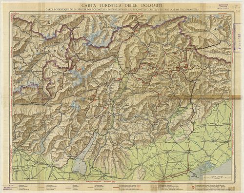
| Title | Carta Turistica delle Dolomiti. – Carte touristique de la région des Dolomites. – Touristenkarte des Dolomitengebietes. – Tourist map of the Dolomites. |
| Main title | A Dolomitok turistatérképe 1930 körül. |