401. La Riviera di Levante da Genova a Sestri. [B VII c 269]
Institute and Museum of Military History •
B VII c
•
B VII Olaszország
•
B I–XV. Európa
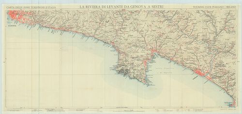
| Title | La Riviera di Levante da Genova a Sestri. |
| Main title | A Genova és Sestri közötti tengerpart térképe az 1900-as évek elején. |
402. Lago di Como. [B VII c 271]
Institute and Museum of Military History •
B VII c
•
B VII Olaszország
•
B I–XV. Európa
| Title | Lago di Como. |
| Main title | A Comoi-tó környékének turistatérképe 1934-ben. |
403. Monte Cervino e conca del Breil. [B VII c 272]
Institute and Museum of Military History •
B VII c
•
B VII Olaszország
•
B I–XV. Európa
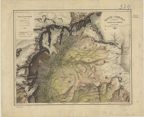
| Title | Monte Cervino e conca del Breil. |
| Main title | A Cervino hegycsúcs és a Breil völgy térképe 1922-ben. |
404. [Olaszország katonaföldrajzi leírása.] [B VII c 280]
Institute and Museum of Military History •
B VII c
•
B VII Olaszország
•
B I–XV. Európa
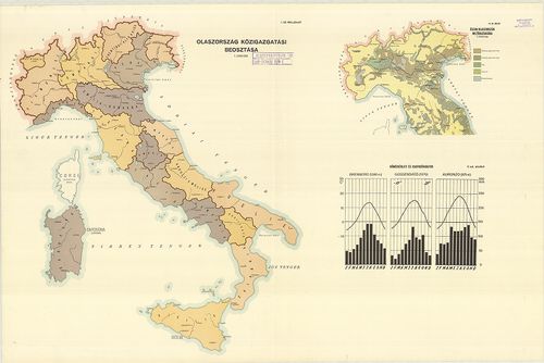
| Title | [Olaszország katonaföldrajzi leírása.] |
| Main title | 12 tl. mell. |
| Subject | 1. Olaszország közigazgatási beosztása. 2. Olaszország hegy és vízrajza. 3. Olaszország talajtérképe. 4. Olaszország nyersanyaglelőhelyei. 5. Olaszország elektromos energiahálózata. 6. Olaszország könnyűipara. 7. Olaszország nehéz- és hadiipara. 8. Olaszország vasúti hálózata. 9. Olaszország közúti hálózata. 10. Olaszország repülőtér-hálózata és kikötői. 11. Olaszország vezetékes hálózata. 12. a., b., c., d. Hőmérsékleti és csapadék adatok. |
405. Carta della densitá media sino al livello del mare in Italia... [B VII c 281]
Institute and Museum of Military History •
B VII c
•
B VII Olaszország
•
B I–XV. Európa
| Title | Carta della densitá media sino al livello del mare in Italia. |
| Main title | Olaszország geofizikai térképe 1954-ben. |
406. Italien. Shell Reisekarte. – Carte automobile Shell Road Map... [B VII c 282]
Institute and Museum of Military History •
B VII c
•
B VII Olaszország
•
B I–XV. Európa
| Title | Italien. Shell Reisekarte. – Carte automobile Shell Road Map Italy, Italie, Italia. |
| Main title | 10 mt.: 1. [Bolzano környéke.] 2. [A Maggiore és Como tó környéke.] 3. [Keleti-Riviéra.] 4. [Nyugati-Riviera.] 5. [Firenze környéke.] 6. [Róma környéke.] 7. [Adriai tengerpart, Rimini és Ancona között.] 8. [Nápoly környéke.] 9. [Szicília keleti partvidéke.] 10. [Szicília nyugati partvidéke.]Olaszország autótérképe 1950 körül. |
407. Italien Strassenatlas. – Italien Road Atlas. – Italia atlant... [B VII c 283]
Institute and Museum of Military History •
B VII c
•
B VII Olaszország
•
B I–XV. Európa
| Title | Italien Strassenatlas. – Italien Road Atlas. – Italia atlante stradale. – Italia atlas routier. |
| Main title | 1. Milano, 2. Génova, 3. Róma, 4. Firenze. |
| Subject | Olaszország úttérképe 1950 körül. |
408. Carta stradale. Piemonte-Liguria. [B VII c 284]
Institute and Museum of Military History •
B VII c
•
B VII Olaszország
•
B I–XV. Európa
| Title | Carta stradale. Piemonte-Liguria. |
| Main title | Olaszország északnyugati részének úttérképe 1965-ben. |
409. Carta automobilistica d’Italia. Foglio 1–30. [B VII c 285]
Institute and Museum of Military History •
B VII c
•
B VII Olaszország
•
B I–XV. Európa
| Title | Carta automobilistica d’Italia. Foglio 1–30. |
| Main title | Olaszország autótérképe 1950–1955-ben. |
410. Carta stradale d’Italia. Foglio: 1., 2. – Italia carta autom... [B VII c 286]
Institute and Museum of Military History •
B VII c
•
B VII Olaszország
•
B I–XV. Európa
| Title | Carta stradale d’Italia. Foglio: 1., 2. – Italia carta automobilistica. – Italie carte automobile. – Italy mapa automovilistico Motoring map – Italien Autokarte. |
| Main title | Olaszország autótérképe 1956-ban. |
411. Carta stradale d’Italia. – Road Map of Italy. – Carte routié... [B VII c 287]
Institute and Museum of Military History •
B VII c
•
B VII Olaszország
•
B I–XV. Európa
| Title | Carta stradale d’Italia. – Road Map of Italy. – Carte routiére d’Italie. – Italien Strassenkarte. |
| Main title | 6 mt.: 1. Torino, 2. Milano, 3. Bologna, 4. Firenze, 5. Róma, 6. Napoli. |
| Subject | Olaszország úttérképe 1964-ben. |
412. Italia carta stradale. Gulf. [B VII c 288]
Institute and Museum of Military History •
B VII c
•
B VII Olaszország
•
B I–XV. Európa
| Title | Italia carta stradale. Gulf. |
| Main title | Olaszország úttérképe 1963-ban. |
413. Italia. Caltex. [B VII c 289]
Institute and Museum of Military History •
B VII c
•
B VII Olaszország
•
B I–XV. Európa
| Title | Italia. Caltex. |
| Main title | Olaszország autótérképe 1963-ban. |
414. Carta automobilistica d’Italia. – Italia carta automobilisti... [B VII c 290]
Institute and Museum of Military History •
B VII c
•
B VII Olaszország
•
B I–XV. Európa
| Title | Carta automobilistica d’Italia. – Italia carta automobilistica. |
| Main title | Olaszország autótérképe 1963-ban. |
415. Carta stradale e turistica Italia. [B VII c 291]
Institute and Museum of Military History •
B VII c
•
B VII Olaszország
•
B I–XV. Európa
| Title | Carta stradale e turistica Italia. |
| Main title | Olaszország út- és turistatérképe 1960 körül. |
416. Italia carta generale. [B VII c 292]
Institute and Museum of Military History •
B VII c
•
B VII Olaszország
•
B I–XV. Európa
| Title | Italia carta generale. |
| Main title | Olaszország általános térképe úthálózattal 1949–1962-ben. |
417. Italien. RV. Landkarte 88. Autokarte. Süddeutschland–Schweiz... [B VII c 293]
Institute and Museum of Military History •
B VII c
•
B VII Olaszország
•
B I–XV. Európa
| Title | Italien. RV. Landkarte 88. Autokarte. Süddeutschland–Schweiz und Tirol… |
| Main title | 12 mt.: 1. Firenze. 2. Trieste. 3. Venezia. 4. Bologna. 5. Torino. 6. Milano. 7. Nápoli. 8. Róma (Rom.) 9. Cagliari. 10. Palermo. 11. Siracusa. 12. Entfernungskarte (Olaszország távolsági úttérképe.) |
| Subject | Olaszország–Dél-Németország–Tirol–Svájc autóúttérképe. |
418. Carte automobile Italie. RV Landkarte 88. Süddeutschland Sch... [B VII c 293/1]
Institute and Museum of Military History •
B VII c
•
B VII Olaszország
•
B I–XV. Európa
| Title | Carte automobile Italie. RV Landkarte 88. Süddeutschland Schweiz und Tirol. |
| Main title | 12 mt.: 1. Innsbruck. 2. Zürich. 3. Milano. 4. Verona. 5. Bolzano. 6. Venezia. 7. Bologna. 8. Firenze. 9. Róma. 10. Siracuza. 11. Napoli. 12. Palermo, városáthajt. térk.Olaszország, Dél-Németország, Svájc és Tirol autótérképe 1950 körül. |
419. Italia. Carta automobilistica. [B VII c 294]
Institute and Museum of Military History •
B VII c
•
B VII Olaszország
•
B I–XV. Európa
| Title | Italia. Carta automobilistica. |
| Main title | 4 mt.: 1. [Városok közötti távolságok.] 2. [Olaszország turistatérképe.] 3. Róma. 4. Milano. |
| Subject | Olaszország autótérképe 1963-ban. |
420. Italia. Esso Carta automobilistica. 3 csatl. kétold. tl. I. ... [B VII c 295]
Institute and Museum of Military History •
B VII c
•
B VII Olaszország
•
B I–XV. Európa
| Title | Italia. Esso Carta automobilistica. 3 csatl. kétold. tl. I. Foglio nord carta automobilistica. II. Foglio centro – sud… III. Sicilia – Sardegna … |
| Main title | Olaszország autótérképe 1962–63-ban. |
421. Italia carta stradale. [B VII c 296]
Institute and Museum of Military History •
B VII c
•
B VII Olaszország
•
B I–XV. Európa
| Title | Italia carta stradale. |
| Main title | Olaszország autós zsebatlasza 1960 körül. |
422. Italia carta stradale. Shell. [B VII c 297]
Institute and Museum of Military History •
B VII c
•
B VII Olaszország
•
B I–XV. Európa
| Title | Italia carta stradale. Shell. |
| Main title | Olaszország úttérképe 1962-ben. |
423. Italia. [B VII c 298-a]
Institute and Museum of Military History •
B VII c
•
B VII Olaszország
•
B I–XV. Európa
| Title | Italia. |
| Main title | 5 mt.: 1. Róma. 2. Napoli e dintorni. (Nápoly és környéke.) 3. La Zona dei Laghi e le sue attrattive turistiche. (A tavak vidéke.) 4. [Olaszország nevezetességei képekkel illusztrálva.] 5. Sardegna. (Szardínia.) |
| Subject | Olaszország turistatérképe 1956-ban. |
424. Italia. [B VII c 298-b]
Institute and Museum of Military History •
B VII c
•
B VII Olaszország
•
B I–XV. Európa
| Title | Italia. |
| Main title | 9 mt.: 1. Róma. 2. Milano. 3. Torino. 4. Bologna. 5. Firenze. 6. I laghi dell’ Italia settentrionale. (Észak-Olaszország tavai.) 7. Sardegna (Szardinia) 8. [Olaszország nevezetességei.] 9. Napoli e dintorni. (Nápoly és környéke.)Olaszország turistatérképe 1961-ben. |
425. Italia carta automobilistica. Foglio 1. [B VII c 299]
Institute and Museum of Military History •
B VII c
•
B VII Olaszország
•
B I–XV. Európa
| Title | Italia carta automobilistica. Foglio 1. |
| Main title | Olaszország autótérképe 1963-ban. |
426. Italia meridionale. Foglio N. 3. [B VII c 300]
Institute and Museum of Military History •
B VII c
•
B VII Olaszország
•
B I–XV. Európa
| Title | Italia meridionale. Foglio N. 3. |
| Main title | Dél-Olaszország (Szicília nélkül) úttérképe 1963-ban. |
427. Italien. Reisekarte Polyglott. [B VII c 301]
Institute and Museum of Military History •
B VII c
•
B VII Olaszország
•
B I–XV. Európa
| Title | Italien. Reisekarte Polyglott. |
| Main title | Olaszország úttérképe 1965-ben. |
428. Carta della circoscrizione elettorale politica dell’ Italia. [B VII c 302]
Institute and Museum of Military History •
B VII c
•
B VII Olaszország
•
B I–XV. Európa
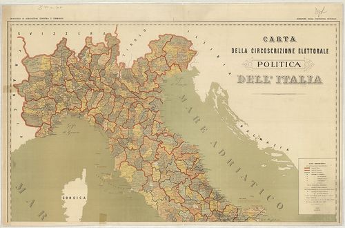
| Title | Carta della circoscrizione elettorale politica dell’ Italia. |
| Main title | Mt.: Provincia di Napoli e parte di quelle di Caserta Avellino e Salerno. (A nápolyi körzet Caserta, Avellino és Salerno egy részével.) |
| Subject | Olaszország közigazgatási térképe választókörzetek szerinti felosztással 1880-ban. |
429. Oberitalien. Venezien Freytag–Berndt Strassenkarte. – Carte ... [B VII c 303]
Institute and Museum of Military History •
B VII c
•
B VII Olaszország
•
B I–XV. Európa
| Title | Oberitalien. Venezien Freytag–Berndt Strassenkarte. – Carte Stradale. – Carte Routiére. – Road Map. |
| Main title | Felső-Olaszország, Veneto tartomány úttérképe 1967-ben. |
430. Italiano Carta. – Touring Club Carta Automobilistica. [B VII c 304]
Institute and Museum of Military History •
B VII c
•
B VII Olaszország
•
B I–XV. Európa
| Title | Italiano Carta. – Touring Club Carta Automobilistica. |
| Main title | Olaszország autótérképe 1955–57-ben. |
431. [Olaszország vasúti menetrend.] [B VII c 305]
Institute and Museum of Military History •
B VII c
•
B VII Olaszország
•
B I–XV. Európa
| Title | [Olaszország vasúti menetrend.] |
432. Olaszország autótérképe. [B VII c 306]
Institute and Museum of Military History •
B VII c
•
B VII Olaszország
•
B I–XV. Európa
| Title | Olaszország autótérképe. |
| Main title | 5 Mt.: 1. Golfo di Nápoli. (Nápolyi-öböl) |
| Subject | 2. Milano. 3. Firenze. 4. Róma. 5. Venézia (Velence) városáthajt. térk. |
433. Italia – Italie – Italien – Italy – Automobilkarte – Carta A... [B VII c 307]
Institute and Museum of Military History •
B VII c
•
B VII Olaszország
•
B I–XV. Európa
| Title | Italia – Italie – Italien – Italy – Automobilkarte – Carta Automobilistica. |
| Main title | 4 mt.: 1. Lugano és a tavak vidéke 2. Milano. 3. Venezia (Velence) 4. Róma. |
| Subject | Olaszország autótérképe 1967-ben. |
434. Italia. 1966. Carta schematica parchi di Campeggio. [B VII c 308]
Institute and Museum of Military History •
B VII c
•
B VII Olaszország
•
B I–XV. Európa
| Title | Italia. 1966. Carta schematica parchi di Campeggio. |
| Main title | Olaszország autóúttérképe 1966-ban. |
435. Italia. 1967/68. Carta schematica parchi di Campeggio. [B VII c 309]
Institute and Museum of Military History •
B VII c
•
B VII Olaszország
•
B I–XV. Európa
| Title | Italia. 1967/68. Carta schematica parchi di Campeggio. |
| Main title | Olaszország autóúttérképe 1967-ben. |
436. Norditalien. Autokarte. [B VII c 310]
Institute and Museum of Military History •
B VII c
•
B VII Olaszország
•
B I–XV. Európa
| Title | Norditalien. Autokarte. |
| Main title | Észak-Olaszország, Svájc, Ausztria és Jugoszlávia egy részének térképe 1971-ben. |
437. Süditalien. Autokarte. [B VII c 311]
Institute and Museum of Military History •
B VII c
•
B VII Olaszország
•
B I–XV. Európa
| Title | Süditalien. Autokarte. |
| Main title | Dél-Olaszország, Szardínia és Szicília szigetek autótérképe 1971-ben. |
438. Italien. Falk plan. [B VII c 312]
Institute and Museum of Military History •
B VII c
•
B VII Olaszország
•
B I–XV. Európa
| Title | Italien. Falk plan. |
| Main title | 14 mt.: 1. Italia architektur. (Építészet) 2. Italia Naturdenkmäler. (Emlékművek) 3. Italia Sport. 4. Riviera Badeorte. (Fürdőhelyek.) 5. Italia (áttekintő). 6. [Milano.] 7. Milano Ausflüge. (Légiközlekedés.) 8. Milano. 9. Firenze. 10. Firenze Ausflüge. (Légiközlekedés) 11. Firenze. 12. Roma. 13. Roma Ausflüge. (Légiközlekedés.) 14. Roma.Olaszország térképe 1970 körül. |
439. Cartoguide Shell-Italia. Touring. [B VII c 313]
Institute and Museum of Military History •
B VII c
•
B VII Olaszország
•
B I–XV. Európa
| Title | Cartoguide Shell-Italia. Touring. |
| Main title | 1. Nord-ovest. (ÉNY) 2. Nord-est. (ÉK) 3. Centro-nord. (Közép-észak.) 4. Centro. (Közép.) 5. Centro-sud. (Közép-dél.) 6. Sud. (Dél.) 7. Sicilia. (Szicília sziget.) 8. Sardegna. (Szardínia sziget.)Olaszország turistatérképe. |
440. Italia. Carta schematica parchi di Campeggio. [B VII c 314]
Institute and Museum of Military History •
B VII c
•
B VII Olaszország
•
B I–XV. Európa
| Title | Italia. Carta schematica parchi di Campeggio. |
| Main title | Olaszország camping térképe. |
441. Flemmings Karte des Italienischen Kriegsschauplatzes. 2 térk... [B VII c 315]
Institute and Museum of Military History •
B VII c
•
B VII Olaszország
•
B I–XV. Európa
| Title | Flemmings Karte des Italienischen Kriegsschauplatzes. 2 térk. egy lapon: 1. Übersichtskarte des Italienisch-österreichischen Grenzgebiets. |
| Main title | (Áttekintőtérkép az Olasz–Osztrák Monarchia határvidékről.) 2. Spezialkarte von Oberitalien zwischen Süd-Tirol und Adria. |
| Subject | (Általános térkép Felső-Olaszország–Dél-Tirol és Adria közötti területről.) |
442. Carta delle zone turistische d’Italia-Bolzano e Dintorni. [B VII c 316]
Institute and Museum of Military History •
B VII c
•
B VII Olaszország
•
B I–XV. Európa
| Title | Carta delle zone turistische d’Italia-Bolzano e Dintorni. |
| Main title | Bolzano és környéke turistatérképe. |
443. Carte routiere d’Italie. Avec les Postes. [B VII c 317]
Institute and Museum of Military History •
B VII c
•
B VII Olaszország
•
B I–XV. Európa
| Title | Carte routiere d’Italie. Avec les Postes. |
| Main title | Itália úttérképe 1833-ban. |
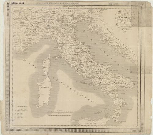
444. General Karte von Italien und Dalmatien [B VII c 318]
Institute and Museum of Military History •
B VII c
•
B VII Olaszország
•
B I–XV. Európa
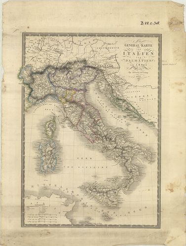
| Title | General Karte von Italien und Dalmatien |
| Main title | Itália és Dalmácia általános térképe 1848-ban. |
445. Carta logistica. Foglio: Adelsberg. [B VII c 319]
Institute and Museum of Military History •
B VII c
•
B VII Olaszország
•
B I–XV. Európa
| Title | Carta logistica. Foglio: Adelsberg. |
| Main title | Adelsberg (Postojna) és környékének logisztikai térképe. |
446. Dietrich Reimer’s Kriegsstandskarten XI. Die Offensive gegen... [B VII c 320]
Institute and Museum of Military History •
B VII c
•
B VII Olaszország
•
B I–XV. Európa
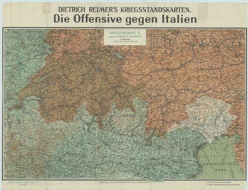
| Title | Dietrich Reimer’s Kriegsstandskarten XI. Die Offensive gegen Italien. |
| Main title | Az olasz ellentámadás térképe 1917. nov. 17-én. |
447. Das italienisch–österreichische Grenzgebiet. [B VII c 321]
Institute and Museum of Military History •
B VII c
•
B VII Olaszország
•
B I–XV. Európa
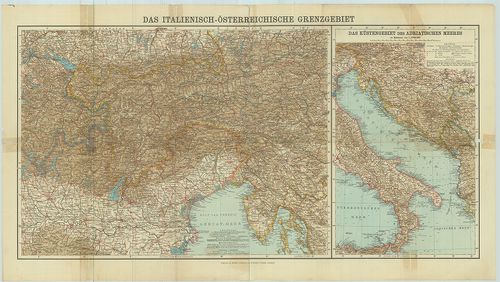
| Title | Das italienisch–österreichische Grenzgebiet. |
| Main title | Mt.: Das Küstengebiet des Adriatischen Meeres (Az Adria-tenger partvidéke.) |
| Subject | Az olasz–osztrák határvidék térképe. |
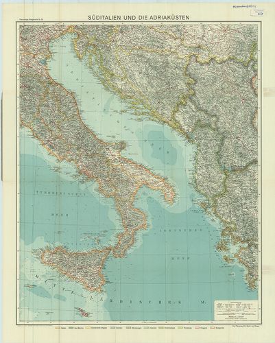
448. Süditalien und die Adriaküsten. [B VII c 322]
Institute and Museum of Military History •
B VII c
•
B VII Olaszország
•
B I–XV. Európa
| Title | Süditalien und die Adriaküsten. |
| Main title | Dél-Olaszország és a Balkán-fsz. adriai partvidékének térképe. |
449. Carta d’Italia speciale per automobilisti, ciclisti e touris... [B VII c 323]
Institute and Museum of Military History •
B VII c
•
B VII Olaszország
•
B I–XV. Európa
| Title | Carta d’Italia speciale per automobilisti, ciclisti e touristi. Foglio 4.: Udine. |
| Main title | Olaszország: Udine és környékének autó- és turistatérképe. |
450. Carta d’Italia speciale per Automobilisti, Ciclisti e Touris... [B VII c 324]
Institute and Museum of Military History •
B VII c
•
B VII Olaszország
•
B I–XV. Európa
| Title | Carta d’Italia speciale per Automobilisti, Ciclisti e Touristi. Foglio 14. Firenze. |
| Main title | Olaszország: Firenze és környékének autó és turista térképe. |