81. Carta Topografica dello Stato di Milano. [B VII a 85]
Institute and Museum of Military History •
B VII a
•
B VII Olaszország
•
B I–XV. Európa
| Title | Carta Topografica dello Stato di Milano. |
| Main title | Milano tartomány topográfiai térképe 1777-ben. |
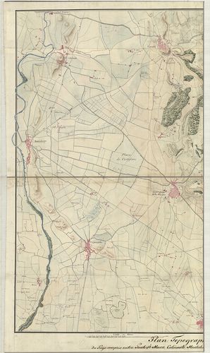
82. Foglio Nord-Ovest dei quattro che compongono i Contorni di M... [B VII a 85/1]
Institute and Museum of Military History •
B VII a
•
B VII Olaszország
•
B I–XV. Európa
| Title | Foglio Nord-Ovest dei quattro che compongono i Contorni di Milano… – Foglio Sud-Est dei quattro che compongono i Contorni di Milano… |
| Main title | Milano ÉNY-i és DNY-i környékének térképe a 19. században. |
83. Carta Topografica del Milanese e Mantovano… [B VII a 90]
Institute and Museum of Military History •
B VII a
•
B VII Olaszország
•
B I–XV. Európa
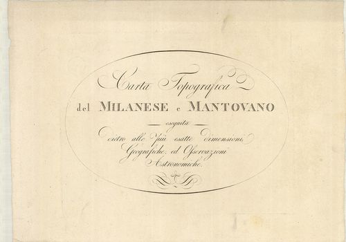
| Title | Carta Topografica del Milanese e Mantovano… |
| Main title | Milano és Mantova tartományok térképe a 18. század második felében. |
84. Il Corso del Po dal Mantovano fino al Mare… [B VII a 91/1]
Institute and Museum of Military History •
B VII a
•
B VII Olaszország
•
B I–XV. Európa
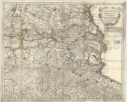
| Title | Il Corso del Po dal Mantovano fino al Mare… |
| Main title | Mantova tartomány és a Pó torkolat környékének térképe 1792-ben. |
85. Il Milanese con parte de’ Paesi… [B VII a 91/2]
Institute and Museum of Military History •
B VII a
•
B VII Olaszország
•
B I–XV. Európa
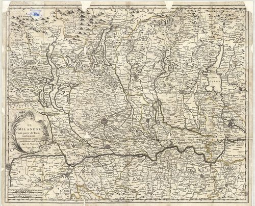
| Title | Il Milanese con parte de’ Paesi… |
| Main title | Milano tartomány és a Pó környékének általános térképe 1792-ben. |
86. Carta Topografica Dei Contorni di Milano… [B VII a 92]
Institute and Museum of Military History •
B VII a
•
B VII Olaszország
•
B I–XV. Európa
| Title | Carta Topografica Dei Contorni di Milano… |
| Main title | Milano tartomány topográfiai térképe 1807-ben. |
87. Nuova Carta dei Contorni di Milano e delle Provincie di Como... [B VII a 96]
Institute and Museum of Military History •
B VII a
•
B VII Olaszország
•
B I–XV. Európa
| Title | Nuova Carta dei Contorni di Milano e delle Provincie di Como, Bergamo, Lodi-Crema, Pavia, Cremona e parte di Brescia. |
| Main title | Milano tartomány térképe 1832-ben. |
88. Carta Topografica Statistica della Provincia di Milano. [B VII a 97/1]
Institute and Museum of Military History •
B VII a
•
B VII Olaszország
•
B I–XV. Európa
| Title | Carta Topografica Statistica della Provincia di Milano. |
| Main title | Milano tartomány topográfiai és statisztikai térképe 1809-ben. |
89. Ducatus Mantuani. [B VII a 99/4]
Institute and Museum of Military History •
B VII a
•
B VII Olaszország
•
B I–XV. Európa
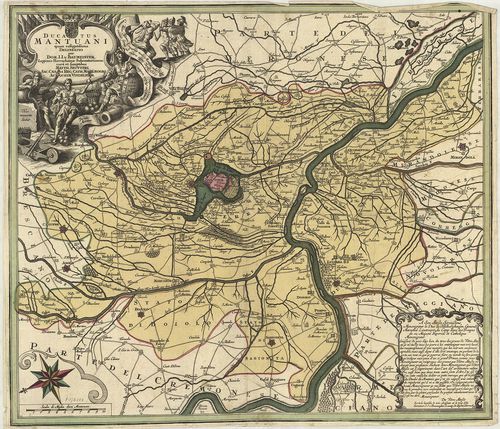
| Title | Ducatus Mantuani. |
| Main title | Mantova hercegség térképe 1740 körül. |
90. Mappa geographica continens Ducatum Mantuanum cum partibus f... [B VII a 107]
Institute and Museum of Military History •
B VII a
•
B VII Olaszország
•
B I–XV. Európa
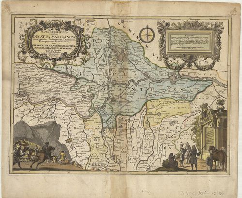
| Title | Mappa geographica continens Ducatum Mantuanum cum partibus finitiorum Ducatuum, Principatuum, Dominiorum ex gr. Cremonae, Parmae, Correggii, Mutinae Bonaniae, Mirandulae, Ferrariae. |
| Main title | Mantova hercegség és a környező részek általános térképe 1734-ben. |
91. Carta Topografica della Provincia di Mantova. [B VII a 109]
Institute and Museum of Military History •
B VII a
•
B VII Olaszország
•
B I–XV. Európa
| Title | Carta Topografica della Provincia di Mantova. |
| Main title | Mantova tartomány topográfiai térképe 1818-ban. |
92. Carta Topografica della Provincia di Pavia. [B VII a 113]
Institute and Museum of Military History •
B VII a
•
B VII Olaszország
•
B I–XV. Európa
| Title | Carta Topografica della Provincia di Pavia. |
| Main title | Mt.: Pianta della R. Citta di Pavia. |
| Subject | Pavia tartomány topográfiai térképe a 19. században. |
93. Topografia della Provincia di Sondrio. [B VII a 114]
Institute and Museum of Military History •
B VII a
•
B VII Olaszország
•
B I–XV. Európa
| Title | Topografia della Provincia di Sondrio. |
| Main title | Sondrio tartomány topográfiai térképe 1825-ben. |
94. Plan der Haide le Grovane bei Barlassina. [B VII a 117]
Institute and Museum of Military History •
B VII a
•
B VII Olaszország
•
B I–XV. Európa
| Title | Plan der Haide le Grovane bei Barlassina. |
| Main title | Grovane vidék (Milanótól északra) térképe a 19. században. |
95. Plan der Gegend zwischen Cantu und Meda. [B VII a 120]
Institute and Museum of Military History •
B VII a
•
B VII Olaszország
•
B I–XV. Európa
| Title | Plan der Gegend zwischen Cantu und Meda. |
| Main title | Cantu és Meda (Milanótól északra) környékének általános térképe a 19. században. |
96. Landesstricht zwischen der Chiese und der Etsch… [B VII a 121]
Institute and Museum of Military History •
B VII a
•
B VII Olaszország
•
B I–XV. Európa
| Title | Landesstricht zwischen der Chiese und der Etsch… |
| Main title | Chiese és Adige folyó közötti terület térképe 1837-ben. |
97. Gegend zwischen Lonato, Castiglione, Monte-Chiari, und Caste... [B VII a 125]
Institute and Museum of Military History •
B VII a
•
B VII Olaszország
•
B I–XV. Európa
| Title | Gegend zwischen Lonato, Castiglione, Monte-Chiari, und Castenedolo. |
| Main title | Olaszország: Észak-Brescia-tól délkeletre eső terület általános térképe 1832 körül. |
98. Gegend Diess und jenseits des Mincio Flusses zwischen Peschi... [B VII a 127/1]
Institute and Museum of Military History •
B VII a
•
B VII Olaszország
•
B I–XV. Európa
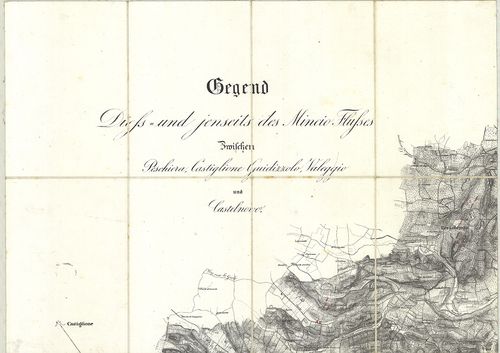
| Title | Gegend Diess und jenseits des Mincio Flusses zwischen Peschiera Castiglione Guidizzolo, Valeggio und Castelnovo. |
| Main title | Olaszország: Észak-Mincio folyó és környékének általános térképe 1835 körül. |
99. Plan Topographique du Pays compris entre Ponte st. Marco, Ca... [B VII a 131/2]
Institute and Museum of Military History •
B VII a
•
B VII Olaszország
•
B I–XV. Európa
| Title | Plan Topographique du Pays compris entre Ponte st. Marco, Calcinato, Montechiaro, Carpenedolo, Medole, Cavriana, Castellaro et Pozzolengo. |
| Main title | Észak-Olaszország: a Garda-tótól délre eső terület általános térképe 1810 körül. |
100. Gegend zwischen Sesto Calende, Soma und Gallarate. [B VII a 132]
Institute and Museum of Military History •
B VII a
•
B VII Olaszország
•
B I–XV. Európa
| Title | Gegend zwischen Sesto Calende, Soma und Gallarate. |
| Main title | Észak-Olaszország: Sesto Calende, Somma és Gallarate (Ticino és Lago Maggiore) környékének általános térképe 1831 körül. |