1181. Kriegstheater zwischen Russland und Franfreich [H IV a 1554]
Institute and Museum of Military History •
H IV a (1700–1820)
•
H IV Újabbkori háborúk
•
H Háborúk
| Title | Kriegstheater zwischen Russland und Franfreich |
| Main title | Az oroszországi – franciaországi hadszíntér. |
1182. Augstellung der Brigaden Kalnassy in ein Lager von Lendva… [H IV a 1555]
Institute and Museum of Military History •
H IV a (1700–1820)
•
H IV Újabbkori háborúk
•
H Háborúk
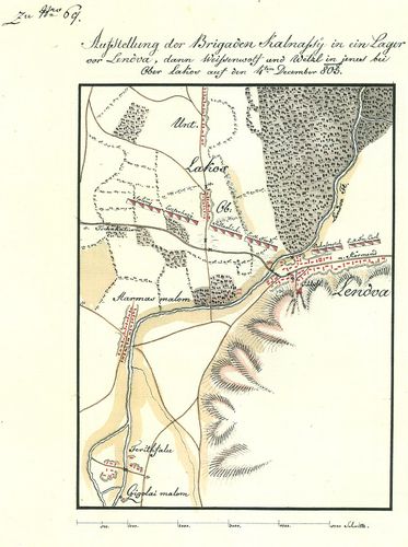
| Title | Augstellung der Brigaden Kalnassy in ein Lager von Lendva… |
| Main title | Lendva környék táborozások terve – a Kalnassy Dandár elhelyezkedése. |
1183. [Baksa.] Aufstellung der Brigaden Wetzl. Weissenwolí u. Kaln... [H IV a 1556]
Institute and Museum of Military History •
H IV a (1700–1820)
•
H IV Újabbkori háborúk
•
H Háborúk
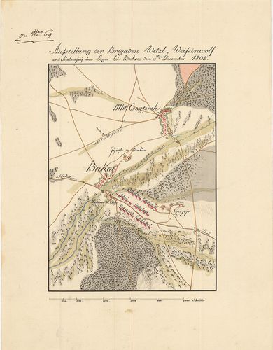
| Title | [Baksa.] Aufstellung der Brigaden Wetzl. Weissenwolí u. Kalnassy, den 5. Dezember. |
| Main title | A Baksa környéki táborozások terve – a Kalnassy Dandár elhelyezkedése. |
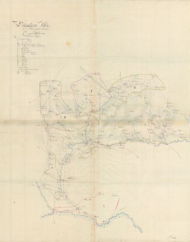
1184. Dislocations Plan im Barcser Comitat 1809. [H IV a 1557]
Institute and Museum of Military History •
H IV a (1700–1820)
•
H IV Újabbkori háborúk
•
H Háborúk
| Title | Dislocations Plan im Barcser Comitat 1809. |
| Main title | Barcs megye diszlokációs térképe. |
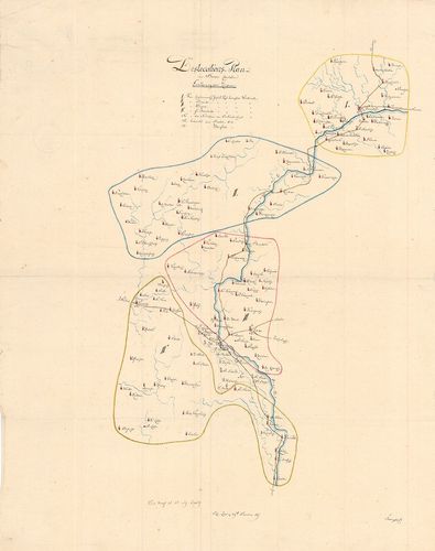
1185. Dislocations Plan der im Honter Comitat befindlichen Truppen... [H IV a 1558]
Institute and Museum of Military History •
H IV a (1700–1820)
•
H IV Újabbkori háborúk
•
H Háborúk
| Title | Dislocations Plan der im Honter Comitat befindlichen Truppen, während der Waffenruhe 1809. |
| Main title | Hont megye diszlokációs térképe. |
1186. Pozsony és Nyitra közötti diszlokáció 1809-ben. [H IV a 1559]
Institute and Museum of Military History •
H IV a (1700–1820)
•
H IV Újabbkori háborúk
•
H Háborúk
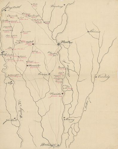
| Title | Pozsony és Nyitra közötti diszlokáció 1809-ben. |
1187. [Tata. Stellungen.] [H IV a 1560]
Institute and Museum of Military History •
H IV a (1700–1820)
•
H IV Újabbkori háborúk
•
H Háborúk
| Title | [Tata. Stellungen.] |
1188. [Dévény. Hidfő.] [H IV a 1561]
Institute and Museum of Military History •
H IV a (1700–1820)
•
H IV Újabbkori háborúk
•
H Háborúk
| Title | [Dévény. Hidfő.] |
1189. Plan des Brückenkopfes bey Pressburg. Anno 1809. [H IV a 1562]
Institute and Museum of Military History •
H IV a (1700–1820)
•
H IV Újabbkori háborúk
•
H Háborúk
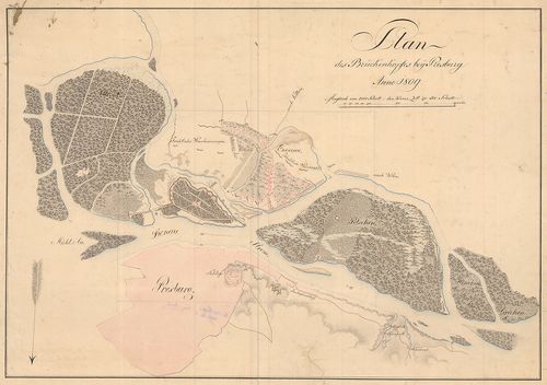
| Title | Plan des Brückenkopfes bey Pressburg. Anno 1809. |
1190. [Hidak Pozsonynál. A francia állások 1809-ben.] [H IV a 1563]
Institute and Museum of Military History •
H IV a (1700–1820)
•
H IV Újabbkori háborúk
•
H Háborúk
| Title | [Hidak Pozsonynál. A francia állások 1809-ben.] |
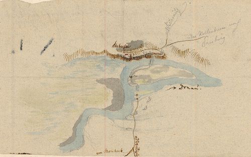
1191. [Hidfőállások Pozsonynál.] [H IV a 1564]
Institute and Museum of Military History •
H IV a (1700–1820)
•
H IV Újabbkori háborúk
•
H Háborúk
| Title | [Hidfőállások Pozsonynál.] |
1192. A la vue Aufnahme gegend am linken Waag Ufer von Salogeska b... [H IV a 1565]
Institute and Museum of Military History •
H IV a (1700–1820)
•
H IV Újabbkori háborúk
•
H Háborúk
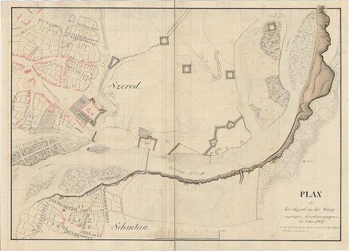
| Title | A la vue Aufnahme gegend am linken Waag Ufer von Salogeska bis Sopornya und Köpösd. |
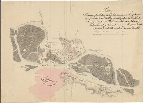
| Main title | A Vág folyó bal oldalán levő települések Szered környékén. |
1193. Plan der bei Szered an der Waag angelegten Verschanzungen im... [H IV a 1566]
Institute and Museum of Military History •
H IV a (1700–1820)
•
H IV Újabbkori háborúk
•
H Háborúk
| Title | Plan der bei Szered an der Waag angelegten Verschanzungen im Jahre 1809. |
| Main title | A Vág folyó melletti Szered környéki sáncok térképe. |
1194. La vie de Napoleon-Bonaparte. 15. aout 1769 – étapes et conq... [H IV b 15]
Institute and Museum of Military History •
H IV b (1821–1840)
•
H IV Újabbkori háborúk
•
H Háborúk
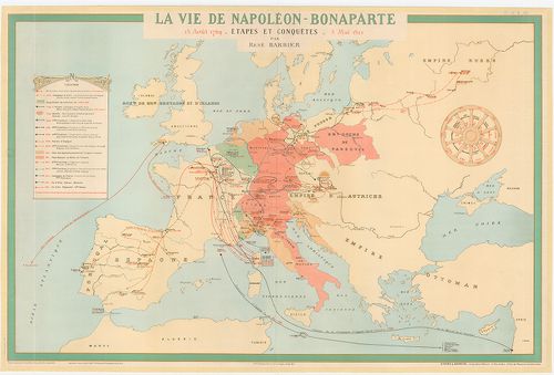
| Title | La vie de Napoleon-Bonaparte. 15. aout 1769 – étapes et conquetes – 5. mai 1821. |
| Main title | Európa vázlatos térképe Napoleon hódító hadjárataival és életének mozzanataival. |
1195. Plan of the position of the allied squadrons and Turkish fle... [H IV b 17]
Institute and Museum of Military History •
H IV b (1821–1840)
•
H IV Újabbkori háborúk
•
H Háborúk
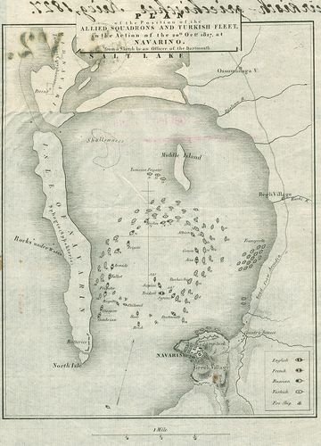
| Title | Plan of the position of the allied squadrons and Turkish fleet in the action of the 20th octr 1827 at Navarino … |
| Main title | Navarinoi (Pylosz, Gör.) tengeri csata vázlatos helyszínrajza 1827. A szövetséges angol, francia, orosz és a török hajóhad felvonulása. |
1196. Karte teatra vojni v Azila 1826, 1827, 1828, 1829 i 1830 god... [H IV b 21]
Institute and Museum of Military History •
H IV b (1821–1840)
•
H IV Újabbkori háborúk
•
H Háborúk
| Title | Karte teatra vojni v Azila 1826, 1827, 1828, 1829 i 1830 godov. |
| Main title | Az ázsiai hadszíntér a Fekete- és a Kaszpi-tenger között 1826–30. Dél-Oroszország és a szomszéd államok. |
1197. Charte des Kriegsschauplatzes von der piedern Donau bis Cons... [H IV b 23]
Institute and Museum of Military History •
H IV b (1821–1840)
•
H IV Újabbkori háborúk
•
H Háborúk
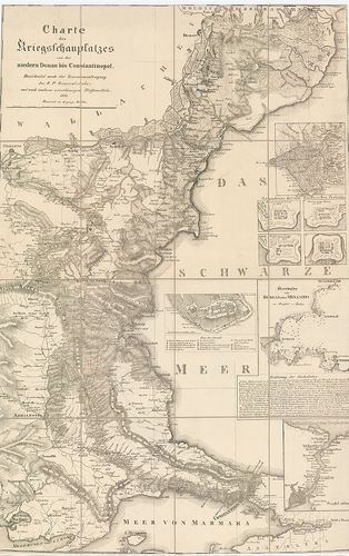
| Title | Charte des Kriegsschauplatzes von der piedern Donau bis Constantinopel. |
| Main title | 5 mt.: 1. [Constantinopel, (Istanbul, Tör.) 2. Grundrisse der vier Dardanellen Festungen (4 alaprajz: 1451–1658-ban a Dardanellák erődítményéről.). 3. [Konstantinápoly (Istanbul) Serrail] 4. Meerbusen von Burgas oder Mesambri (A Burgasz-i öböl és Neszebir, Bulg.) 5. Vertheidigung des Bosphorus. (A Boszporusz védelme). |
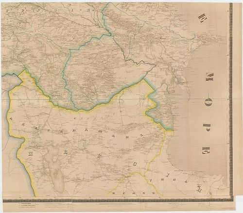
1198. Carte des possessions Russes au-dela du Caucase et des provi... [H IV b 28]
Institute and Museum of Military History •
H IV b (1821–1840)
•
H IV Újabbkori háborúk
•
H Háborúk
| Title | Carte des possessions Russes au-dela du Caucase et des provinces Turques limitrophes dressée sur des documents officiels en 1840. |
| Main title | 1. Plan de la Bataille. Livrée le 19 Juin 1829 prés du village de Kainli dans les gorges du Saganlugh par les troupes Rus es aux ordres du Général Comte Paskeritoh, a l’armée Turque commandée parle Seraskier d’Arzerum Salegh-Pach. (1829. jún. 19-én Kainli-falu közelében a Saganlugh szorosban (Tör.), Paskievics generális orosz hadserege és Arzerum Kormányzója Salegh-Pasa serege között lefolyt csata helyszínrajza.)2. Plan du camp de Hagkhi-Pacha dans les gorges du Milli-Duz onlevé d’assaut par les t roupes Russes aux ordres du Maréchal Paskevitch le 20 juin 1829. (Hagkhi pasa táborának helyszínrajza. Paskievics marsal által 1829. jún. 20-án vezetett orosz csapatok rohama a Milli–Duz szorosban (Tör.)3. Plan de la bataille. Livrés le 9 Aout sous Akhaltsikh par les troupes Russes aux ordres du Maréchal Paskevitch a l’armée Turque forte de 30 000 hommes et commandée par kiossa-Méhémed et Mustapha-Pacha. ([1829] aug. 9-én Parkievics marsall vezetése alatt Mehemed parancsnok és Mustafa pasa 30 000 ember erősségű csapata ellen lefolyt csata helyszínrajza Akhaltsikh (Ahalcihe) város alatt.)4. Plan du siége et de l’assaut D’akhaltsikh du 5 au 15 Aout parles troupes Russes sous les ordres du Maréchal Paskewitch. ([1829.] aug. 15-én Akhaltsikh (Ahaicine) város ellen Pashewics marsal által vezetett ostrom helyszínrajza.)5. Plan de siége et de l’assaut de la Forteresse de Kars. (Kars erőd ellen vezetett roham helyszínrajza.)Kaukázus és a török tartományokkal határos orosz területek térképe, hivatalos adatok szerint 1840-ben. |
1199. [Orosz–török hadműveletek 1829. jún. 8–21. között Kars (Tör.... [H IV b 29]
Institute and Museum of Military History •
H IV b (1821–1840)
•
H IV Újabbkori háborúk
•
H Háborúk
| Title | [Orosz–török hadműveletek 1829. jún. 8–21. között Kars (Tör.) mellett Milli… Duz térségében Paskievics Salegh-Pasa, és Hagkhi pasa vezetésével.] |
1200. Plan Ataki i ovladenija prisztupoty ukreplenij predtesztiety... [H IV b 44]
Institute and Museum of Military History •
H IV b (1821–1840)
•
H IV Újabbkori háborúk
•
H Háborúk
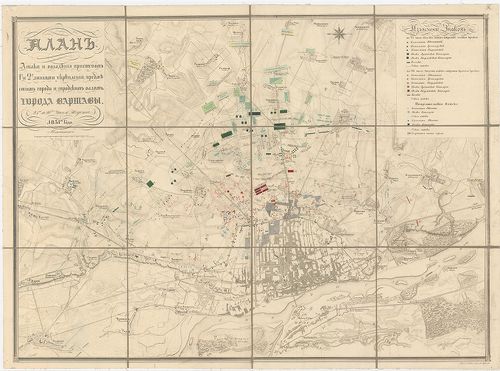
| Title | Plan Ataki i ovladenija prisztupoty ukreplenij predtesztiety goroda i gorodszkity vadoty Goroda Varsavü 25–26. csiszel Auguszta 1831. goda. |
| Main title | 1. Rapport an der Kaiser. Warschau. D. 15. (27.) Sept. 1831. |
| Subject | 2. Erklärung der Zeichen. |