101. Kriegsschauplatz Böhmen, Mähren, Schlesien und Nordost-Deuts... [H IV c 235/2]
Institute and Museum of Military History •
H IV c (1841–1913)
•
H IV Újabbkori háborúk
•
H Háborúk
| Title | Kriegsschauplatz Böhmen, Mähren, Schlesien und Nordost-Deutschland. |
| Main title | Cseh- és Morvaország, Szilézia és Északkelet-Németország mint az 1866. évi porosz–osztrák háború hadműveleteinek színtere. Megerősített helyek, felvonulási utak, távolsági és geológiai adatok a térképben. |
102. Gefechtsfeld von Nachod, Skalitz und Schweinschädel. [H IV c 235/3]
Institute and Museum of Military History •
H IV c (1841–1913)
•
H IV Újabbkori háborúk
•
H Háborúk
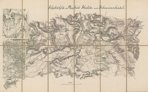
| Title | Gefechtsfeld von Nachod, Skalitz und Schweinschädel. |
| Main title | 2 Mt.: 1. [Hrade-Techlowitz] 2. Übersichts-Plan zum Gefecht von. Nachod. (Náchod környéki csaták.)A Náchod, Skalitz (Česka Skalica) és Schweinschädel (Sviništ’any, Cs.) (1866. évi porosz–osztrák háború.) Útvonalak. |
103. Gefecht von Trautenau am 27. Juni und von Trautenau – Soor a... [H IV c 236/1]
Institute and Museum of Military History •
H IV c (1841–1913)
•
H IV Újabbkori háborúk
•
H Háborúk
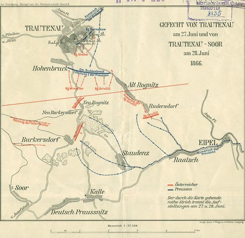
| Title | Gefecht von Trautenau am 27. Juni und von Trautenau – Soor am 28. Juni 1866. |
| Main title | A trautenaui (Trutnov) és a trautenau–soori ütközet vázlatos helyszínrajza 1866. (Csehország. Porosz–osztrák háború.) hadállások, hadmozdulatok. |
104. Das Schlachtfeld von Königgrätz [3. Juli, 1866.] [H IV c 237]
Institute and Museum of Military History •
H IV c (1841–1913)
•
H IV Újabbkori háborúk
•
H Háborúk
| Title | Das Schlachtfeld von Königgrätz [3. Juli, 1866.] |
| Main title | A königgrätzi (Hradec Králové) csata helyszíne 1866. (Csehország. Porosz–osztrák háború.) |
105. Anleitung zur Verfassung von Situations und Rekognoszierungs... [H IV c 237/2]
Institute and Museum of Military History •
H IV c (1841–1913)
•
H IV Újabbkori háborúk
•
H Háborúk
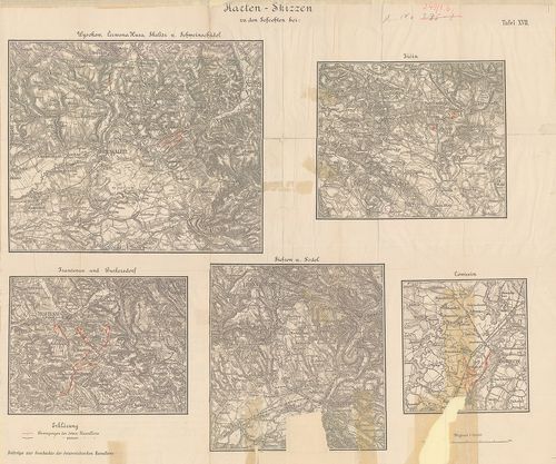
| Title | Anleitung zur Verfassung von Situations und Rekognoszierungs. Skizzen [1866.] |
| Main title | A Königgrätz (Hradec Králové) továbbá a Jičin, Schweinschädel, (Sviništ’any) Skalitz (Česka Skalice) Trautenau (Trutnov) és Wysokow melletti csaták tereptani és harcászati kiértékeléséhez készült látképes terepvázlatok, mint tansegédlet. |
106. Königgrätz. Kurze Darstellung der Schlacht am 3. Juli 1866. [H IV c 237/4]
Institute and Museum of Military History •
H IV c (1841–1913)
•
H IV Újabbkori háborúk
•
H Háborúk
| Title | Königgrätz. Kurze Darstellung der Schlacht am 3. Juli 1866. |
| Main title | A königgrätzi (Hradec Králové, Cs.) csata részletes térképei. A „Königgrätz” c. mű térképmellékletei. |
107. Plan zu Schlacht von Königgrätz [H IV c 237/5]
Institute and Museum of Military History •
H IV c (1841–1913)
•
H IV Újabbkori háborúk
•
H Háborúk
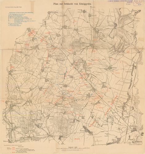
| Title | Plan zu Schlacht von Königgrätz |
| Main title | A königgrätzi (Hradec Králové, Cs.) csata helyszínrajza 1866. Porosz és osztrák hadállások, hadmozdulatok. I. Vilmos porosz király hadinaplójának részletei. |
108. Plan des Gefechtsfeldes von Gitshen (den. 29.–Juni 1866.) [H IV c 237/6]
Institute and Museum of Military History •
H IV c (1841–1913)
•
H IV Újabbkori háborúk
•
H Háborúk
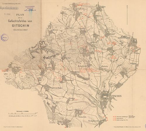
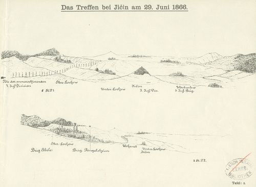
| Title | Plan des Gefechtsfeldes von Gitshen (den. 29.–Juni 1866.) |
| Main title | A gitsheni csata helyszínrajza 1866. Porosz, osztrák, szász hadállások hadmozdulatok. I. Vilmos porosz király hadinaplójának részletei |
109. Nordöstlicher Kriegsschauplatz 1866. [H IV c 237/7]
Institute and Museum of Military History •
H IV c (1841–1913)
•
H IV Újabbkori háborúk
•
H Háborúk
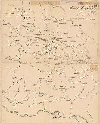
| Title | Nordöstlicher Kriegsschauplatz 1866. |
| Main title | Glogau – Wien – Prága – Troppau közötti térség. Csehország mint az 1866. évi porosz–osztrák háború színtere. |
110. Situation bei Chlum am 3. Juli 1866. gegen 2h30m nachmittags... [H IV c 238/8]
Institute and Museum of Military History •
H IV c (1841–1913)
•
H IV Újabbkori háborúk
•
H Háborúk
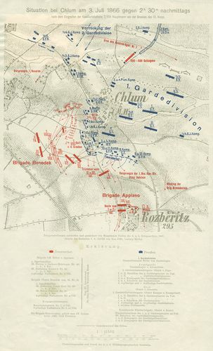
| Title | Situation bei Chlum am 3. Juli 1866. gegen 2h30m nachmittags… |
| Main title | A chlumi (Cs.) csata vázlatos helyszínrajza 1866. (Porosz–osztrák háború Csehországban.) Hadállások, hadmozdulatok. Útvonalak. |
111. Marsch-Routen Karte für die Armee-Corps und Cavallerie-Divis... [H IV c 238/16]
Institute and Museum of Military History •
H IV c (1841–1913)
•
H IV Újabbkori háborúk
•
H Háborúk
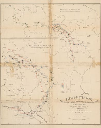
| Title | Marsch-Routen Karte für die Armee-Corps und Cavallerie-Divisionen der Oesterreichischen Armee im Feldzuge 1866. 1. Märsche bis zum 3ten Juli. 2. Rückzug hinter die Donak. |
| Main title | Menettérkép az osztrák hadtestek és lovashadosztályok számára az 1866. évi hadjáratban. Brünn és Königgrätz közötti térség. Visszavonulás a Duna vonala mögé. |
112. Der Feldzug 1866. in Böhmen bis einschliesslich der Schlacht... [H IV c 238/17]
Institute and Museum of Military History •
H IV c (1841–1913)
•
H IV Újabbkori háborúk
•
H Háborúk
| Title | Der Feldzug 1866. in Böhmen bis einschliesslich der Schlacht von Königrätz. |
| Main title | A csehországi hadjárat 1866-ban a königrätzi csatáig. |
113. Oesterreichs-Kämpfe im Jahre 1866. [H IV c 245]
Institute and Museum of Military History •
H IV c (1841–1913)
•
H IV Újabbkori háborúk
•
H Háborúk
| Title | Oesterreichs-Kämpfe im Jahre 1866. |
| Main title | Ausztria harcai 1866-ban a poroszokkal és az olaszokkal. |
114. Operations Karte des oberitalienischen Kriegsschauplatzes. N... [H IV c 247]
Institute and Museum of Military History •
H IV c (1841–1913)
•
H IV Újabbkori háborúk
•
H Háborúk
| Title | Operations Karte des oberitalienischen Kriegsschauplatzes. Nach den Neuesten Landesbeschreibungsmaterialien zusammengestellt. 1863. Generalkarte des Lombardisch-Venetianischen Königreiches… im Jahre 1838. c. térk.-re nyomva. |
| Main title | Az észak-olaszországi osztrák–olasz háború hadműveleti térképe. Megerősített helyek, hídfők, hadállások, útvonalak, átkelőhelyek. A Lombard-velencei királyság politikai felosztása. |
115. Schlacht von Custozza am 24. Juni 1866. [H IV c 249]
Institute and Museum of Military History •
H IV c (1841–1913)
•
H IV Újabbkori háborúk
•
H Háborúk
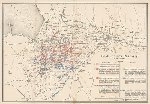
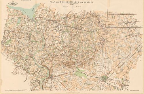
| Title | Schlacht von Custozza am 24. Juni 1866. |
| Main title | A custozzai (Ol.) csata helyszínrajza 1866. Olasz és osztrák hadállások, hadmozdulatok. Útvonalak. |
116. Karte zur Schlacht bei Solfererino 1859 und Custoza 1866. da... [H IV c 249/1a]
Institute and Museum of Military History •
H IV c (1841–1913)
•
H IV Újabbkori háborúk
•
H Háborúk
| Title | Karte zur Schlacht bei Solfererino 1859 und Custoza 1866. dann… |
| Main title | Mt.: Zum Gefecht bei Nogaredo-Versa. (Nogaredo-Versa-i ütközet) A solferinoi (1859) és a custozai (1866) csata térképe. |
117. Karten-Skizze zu den Gefechten bei: Siehrow und Podol – Ošwi... [H IV c 249/1b]
Institute and Museum of Military History •
H IV c (1841–1913)
•
H IV Újabbkori háborúk
•
H Háborúk
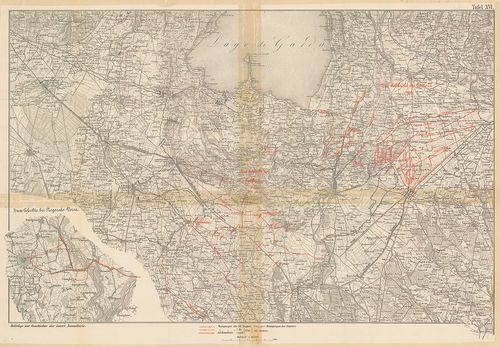
| Title | Karten-Skizze zu den Gefechten bei: Siehrow und Podol – Ošwieçin – Trautenau und Burkerşdorf, Wysokow, Čerwena Hura, Skalitz und Schweinschädel, dann Jičin. |
| Main title | Podol-Ošwiecin-Trutnov-Sviništany- és Jičin melletti csaták térképe. |
118. Das k[aiserliche] k[önigliche] Linien Infanterie Regiment Nr... [H IV c 249/2]
Institute and Museum of Military History •
H IV c (1841–1913)
•
H IV Újabbkori háborúk
•
H Háborúk
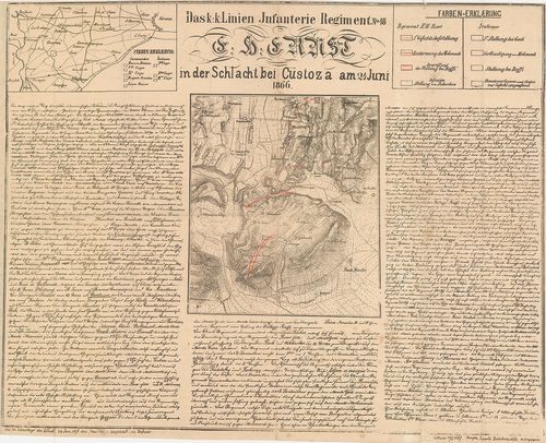
| Title | Das k[aiserliche] k[önigliche] Linien Infanterie Regiment Nr. 48. E[rz] H[erzog] Ernst in der Schlacht bei Custoza (Ol.) am 24. Juni 1866. |
| Main title | Mt.: [Verona (Ol.) környéke.]A cs. kir. Ernő főherceg 48. sz. gyalogezred a custozzai csatában 1866. Custozza és környéke az osztrák és olasz csapatok hadmozdulataival. Részletes ismertetés. A csata 30. évfordulójára 1896. |
119. Plan des Schlachtfeldes von Custoza am 24 Juni 1866. [H IV c 249/4]
Institute and Museum of Military History •
H IV c (1841–1913)
•
H IV Újabbkori háborúk
•
H Háborúk
| Title | Plan des Schlachtfeldes von Custoza am 24 Juni 1866. |
| Main title | A custozzai csatatér és környéke (Ol.). |
120. Plan des Schlachtfeldes von Custozza am 24. Juni 1866. („Zu ... [H IV c 250]
Institute and Museum of Military History •
H IV c (1841–1913)
•
H IV Újabbkori háborúk
•
H Háborúk
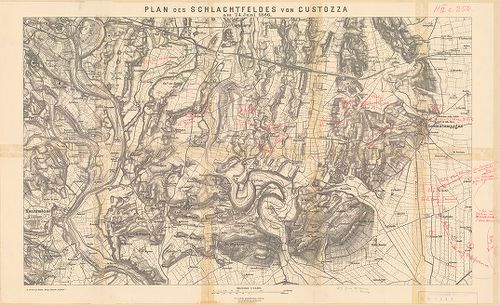
| Title | Plan des Schlachtfeldes von Custozza am 24. Juni 1866. („Zu Oberst von Mathes: Einige taktische Aufgaben”.) |
| Main title | A custozzai csata helyszínrajza (Ol.) 1866. Osztrák és olasz hadállások, hadmozdulatok kézzel bejelölve. |
121. Kampf um Custoza und Monte Torre nach 5h N. [M. (in der Schl... [H IV c 250/1]
Institute and Museum of Military History •
H IV c (1841–1913)
•
H IV Újabbkori háborúk
•
H Háborúk
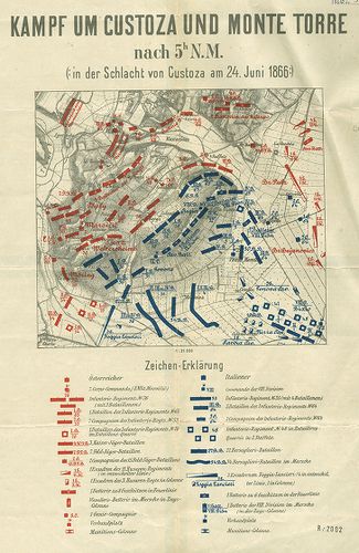
| Title | Kampf um Custoza und Monte Torre nach 5h N. [M. (in der Schlacht von Custoza am 24. Juni 1866.) |
| Main title | A custozzai csata helyszínrajza (Ol.) 1866. Osztrák és olasz hadállások. A csata története a térkép hátlapján. |
122. Skizzen zur orientirung über den Feldzug 1866 in Italien. (S... [H IV c 250/2]
Institute and Museum of Military History •
H IV c (1841–1913)
•
H IV Újabbkori háborúk
•
H Háborúk
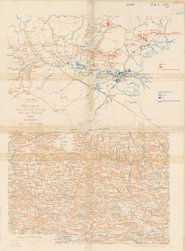
| Title | Skizzen zur orientirung über den Feldzug 1866 in Italien. (Skizze 6.) Taf. XXXIII. |
| Main title | Az olasz–osztrák háború hadállásai és hadmozdulatai Verona távolabbi térségében, 1866. |
123. Der Krieg 1866 in Italien und Südtirol. XI. Spezialkarte der... [H IV c 251/2]
Institute and Museum of Military History •
H IV c (1841–1913)
•
H IV Újabbkori háborúk
•
H Háborúk
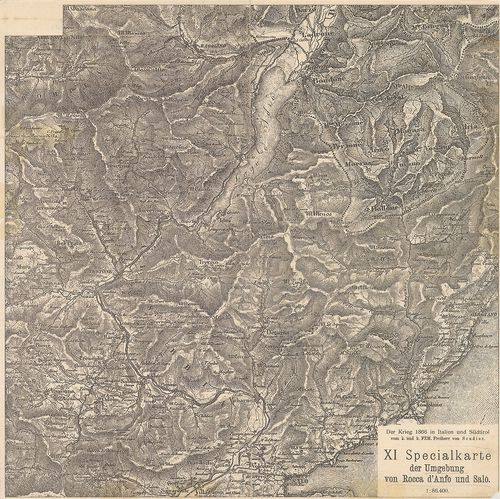
| Title | Der Krieg 1866 in Italien und Südtirol. XI. Spezialkarte der Umgebung von Rocca d’Anfo und Salo. |
| Main title | Rocca d’Anfo és Saló (Ol.) közötti térség az 1866. évi olaszországi hadjáratban. |
124. Der Krieg 1866 in Italien und Südtirol. XII. Specialkarte de... [H IV c 251/3]
Institute and Museum of Military History •
H IV c (1841–1913)
•
H IV Újabbkori háborúk
•
H Háborúk
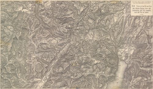
| Title | Der Krieg 1866 in Italien und Südtirol. XII. Specialkarte des Chiese-Thales bzw. der Judicarien, der Val Ampola und der Val di Ledro. |
| Main title | A Chiese-völgy, a Giudicariák, az Ampola és a Ledro-völgy (Ol.) térségének részletes térképe. (Olasz–osztrák háború 1866.) |
125. Angriff der Brigade Waldstätten… [1866.] [H IV c 252/2]
Institute and Museum of Military History •
H IV c (1841–1913)
•
H IV Újabbkori háborúk
•
H Háborúk
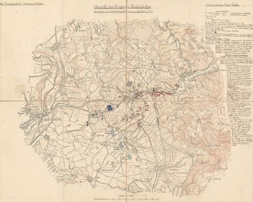
| Title | Angriff der Brigade Waldstätten… [1866.] |
| Main title | Náchod-Wysokow-Skalitz térségében lefolyt ütközet helyszínrajza, 1866. (Porosz–osztrák háború.) Hadállások, hadmozdulatok. A csata két mozzanata. A csata leírása, a tk. szélén. gótb. kézir. (Hadiiskolai dolgozat.) |
126. Topographische Karte der Umgebung von Metz. Die Kriegsoperat... [H IV c 259]
Institute and Museum of Military History •
H IV c (1841–1913)
•
H IV Újabbkori háborúk
•
H Háborúk
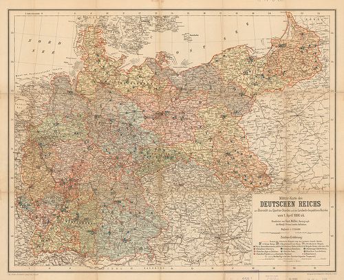
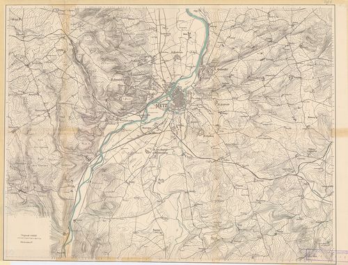
| Title | Topographische Karte der Umgebung von Metz. Die Kriegsoperationen um Metz im Jahre 1870. |
| Main title | Hátl.: Militär-Karte des Deutschen Reichs zur Übersicht des Quartier-Standes und der Landwehr-Inspektions-Bezirke vom 1 April 1890 ab. |
| Subject | Metz [Fr.] körüli csaták 1870. aug. 16., 18., 31.–szept. 1. és 1890-ben.A Német Birodalom katonai kerületi felügyelőség alakulatainak állomáshelyei 1890. április 1-jén. |
127. [Der Feldzug in Frankreich 1870 bis zur Schlacht bei Sedan.] [H IV c 260]
Institute and Museum of Military History •
H IV c (1841–1913)
•
H IV Újabbkori háborúk
•
H Háborúk
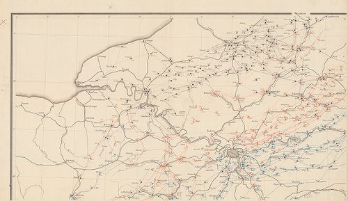
| Title | [Der Feldzug in Frankreich 1870 bis zur Schlacht bei Sedan.] |
| Main title | Franciaországi hadjárat, Sedan melletti csata térképei 1870-ben. |
128. [Der Feldzug in Frankreich 1870–71. II. Teil.] [H IV c 260/1]
Institute and Museum of Military History •
H IV c (1841–1913)
•
H IV Újabbkori háborúk
•
H Háborúk
| Title | [Der Feldzug in Frankreich 1870–71. II. Teil.] |
| Main title | Franciaországi hadjárat 1870–71-ben. |
129. Handtke’s Karte des Deutsch-Französischen Kriegsschauplatzes... [H IV c 261]
Institute and Museum of Military History •
H IV c (1841–1913)
•
H IV Újabbkori háborúk
•
H Háborúk
| Title | Handtke’s Karte des Deutsch-Französischen Kriegsschauplatzes. |
| Main title | A német–francia hadszíntér 1870. Német, francia, belga és holland határterületek. |
130. Deutsch-Französischer Kriegsschauplatz (Westlich von Paris N... [H IV c 262]
Institute and Museum of Military History •
H IV c (1841–1913)
•
H IV Újabbkori háborúk
•
H Háborúk
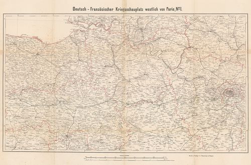
| Title | Deutsch-Französischer Kriegsschauplatz (Westlich von Paris No I–II.) |
| Main title | A német–francia háború hadszíntere Párizstól (Fr.) nyugatra 1870–71. |
131. Übersichtskarte von Nordost-Frankreich in den Jahren 1870–71... [H IV c 262/1]
Institute and Museum of Military History •
H IV c (1841–1913)
•
H IV Újabbkori háborúk
•
H Háborúk
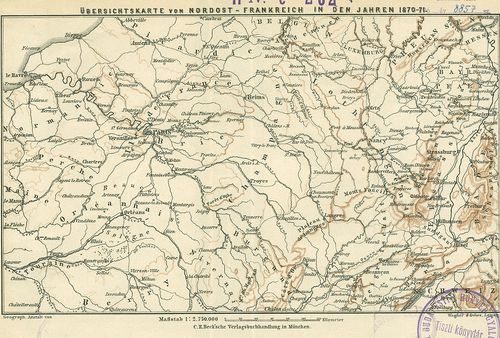
| Title | Übersichtskarte von Nordost-Frankreich in den Jahren 1870–71. |
| Main title | Északkelet-Franciaország áttekintő térképe. (Német–francia háború 1870–71.) |
132. Karte des Südöstlichen Kriegsschaupatzes. [H IV c 262/2]
Institute and Museum of Military History •
H IV c (1841–1913)
•
H IV Újabbkori háborúk
•
H Háborúk
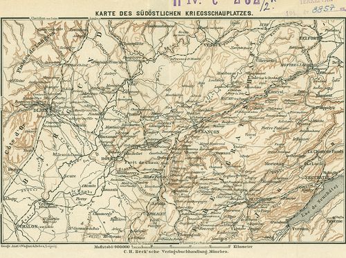
| Title | Karte des Südöstlichen Kriegsschaupatzes. |
| Main title | Délkelet-Franciaország térképe. (Német–francia háború 1870–71.) |
133. Karte zum Feldzug an der Loire und Sarthe. [H IV c 262/3]
Institute and Museum of Military History •
H IV c (1841–1913)
•
H IV Újabbkori háborúk
•
H Háborúk
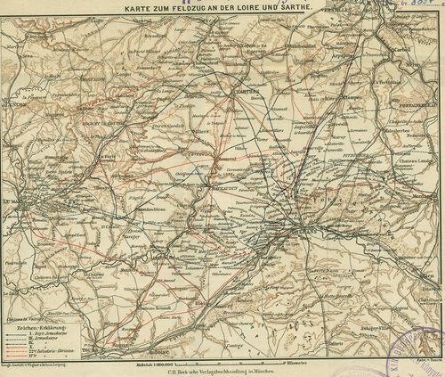
| Title | Karte zum Feldzug an der Loire und Sarthe. |
| Main title | A Loire–Sarthe (Fr.) közötti hadjárat térképe. (Német–francia háború 1870–71.) A hadjárat útvonalai bejelölve. |
134. Karte der Schlachtfelder von Beaumont und Sedan. [H IV c 262/4]
Institute and Museum of Military History •
H IV c (1841–1913)
•
H IV Újabbkori háborúk
•
H Háborúk
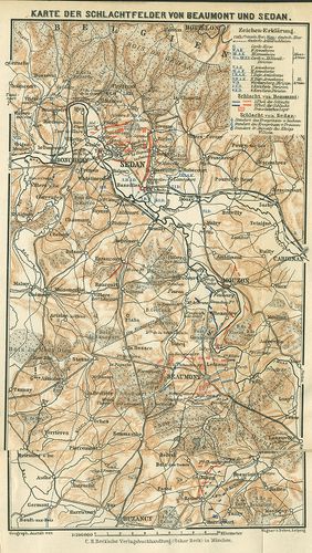
| Title | Karte der Schlachtfelder von Beaumont und Sedan. |
| Main title | A beamonti és sedani (Fr.) csataterek térképe. (Német–francia háború 1870–71.) |
135. Plan zur Belagerung von Belfort und zur Schlacht an der Lisa... [H IV c 262/5]
Institute and Museum of Military History •
H IV c (1841–1913)
•
H IV Újabbkori háborúk
•
H Háborúk
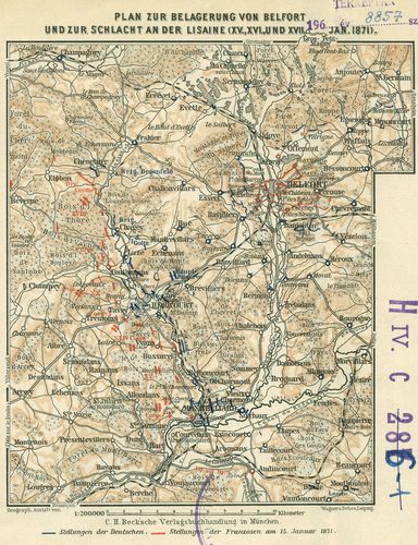
| Title | Plan zur Belagerung von Belfort und zur Schlacht an der Lisaine (XV., XVI. und XVII. Jan. 1871.) |
| Main title | Belfort (Fr.) ostroma és a Lisaine melletti csata helyszínrajza 1871. (Német–francia háború 1870–71.) Hadállások. Útvonalak. |
136. Der deutsch-französische Kriegsschauplatz [H IV c 263/1]
Institute and Museum of Military History •
H IV c (1841–1913)
•
H IV Újabbkori háborúk
•
H Háborúk
| Title | Der deutsch-französische Kriegsschauplatz |
| Main title | A német–francia hadszíntér 1870. Német, francia, belga és holland határterületek. Szín. Országok szerint. |
137. [Siegeszug der 22. Division in Frankreich, 1871.] [H IV c 268]
Institute and Museum of Military History •
H IV c (1841–1913)
•
H IV Újabbkori háborúk
•
H Háborúk
| Title | [Siegeszug der 22. Division in Frankreich, 1871.] |
| Main title | 1 mt.: Umgebung von Paris. (Párizs és környéke.)Német–francia háború 1871. A 22. német hadosztály előnyomulása Páris–Orleans–Alencon–Rouen térségében. A hadjárat útvonala, csaták helyei. |
138. Marsch-Routen Karte für die Armee-Corps resp. Infanterie- u.... [H IV c 271]
Institute and Museum of Military History •
H IV c (1841–1913)
•
H IV Újabbkori háborúk
•
H Háborúk
| Title | Marsch-Routen Karte für die Armee-Corps resp. Infanterie- u. Cavallerie-Divisionen der deutschen Armeen im Kriege gegen Frankreich 1870/71. |
| Main title | A német hadsereg menetparancs-térképe az 1870–71. évi franciaországi hadjáratban. Felvonulási utak. |
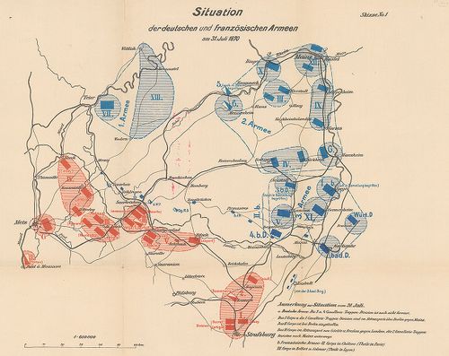
139. Schlacht bei Sedan. Stellung der beiderseitigen Armen gegen ... [H IV c 274]
Institute and Museum of Military History •
H IV c (1841–1913)
•
H IV Újabbkori háborúk
•
H Háborúk
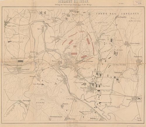
| Title | Schlacht bei Sedan. Stellung der beiderseitigen Armen gegen 12 Uhr Mittags. (1870. szept. 1.) |
| Main title | A sedani (Fr.) csata helyszínrajza, német és francia hadállások, ágyúállások, útvonalak. |
140. Schlacht bei Sedan. [H IV c 274/1]
Institute and Museum of Military History •
H IV c (1841–1913)
•
H IV Újabbkori háborúk
•
H Háborúk
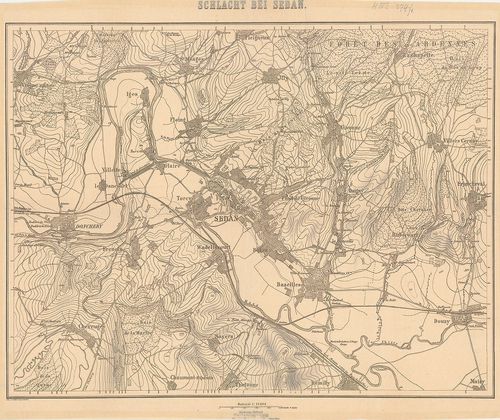
| Title | Schlacht bei Sedan. |
| Main title | Sedan (Fr.) és környékének térképe. |
141. Stellung der Franzosen am Morgen des 1-sten September [bei S... [H IV c 275]
Institute and Museum of Military History •
H IV c (1841–1913)
•
H IV Újabbkori háborúk
•
H Háborúk
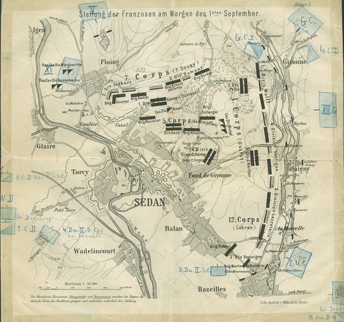
| Title | Stellung der Franzosen am Morgen des 1-sten September [bei Sedan]. |
| Main title | A sedani (Fr.) csata helyszínrajza, 1870. Sedan és erődítései alaprajzban. (Német–francia háború 1870–71.) Francia hadállások, hadmozdulatok. Felvonulási utak. Csapatjelzések, parancsnokok nevei a térképen. Színes ceruzával külön bejegyzések. (Skizze 5 ismeretlen műből.) |
142. Schlacht bei Spicheren 1870–71. [H IV c 276]
Institute and Museum of Military History •
H IV c (1841–1913)
•
H IV Újabbkori háborúk
•
H Háborúk
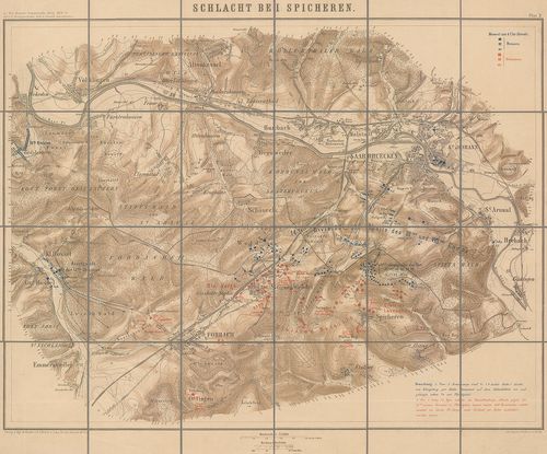
| Title | Schlacht bei Spicheren 1870–71. |
| Main title | Spicheren és környékének csatatérképe. |
143. Plan zum Treffen bei Villepion am 1. Dezember 1870. [H IV c 278/1]
Institute and Museum of Military History •
H IV c (1841–1913)
•
H IV Újabbkori háborúk
•
H Háborúk
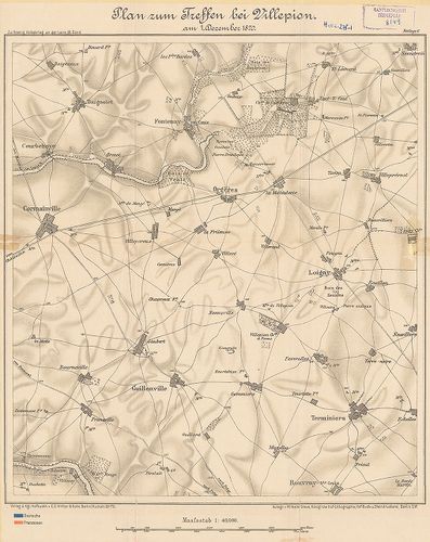
| Title | Plan zum Treffen bei Villepion am 1. Dezember 1870. |
| Main title | A villepioni (Fr.) csata helyszínrajza, 1870. (Német–francia háború 1870–71.) 3 db oleátával a hadmozdulatokról. |
144. A nouarti ütközet [helyszínrajza] 1870. augusztus 29-én. [H IV c 278/2]
Institute and Museum of Military History •
H IV c (1841–1913)
•
H IV Újabbkori háborúk
•
H Háborúk
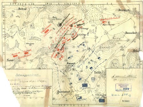
| Title | A nouarti ütközet [helyszínrajza] 1870. augusztus 29-én. |
| Main title | Nouart (Fr.) környéke. (Német–francia háború 1870–71.) Hadállások, hadmozdulatok. Útvonalak. |
145. Schlacht bei Beaumont 30. August 1870. Gefecht bei Remilly s... [H IV c 279]
Institute and Museum of Military History •
H IV c (1841–1913)
•
H IV Újabbkori háborúk
•
H Háborúk
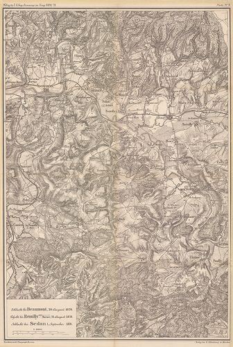
| Title | Schlacht bei Beaumont 30. August 1870. Gefecht bei Remilly sur Meuse 31. August 1870. Schlacht bei Sedan 1. September 1870. |
| Main title | A porosz–francia háború 1870–71. Baumont Remilly, Sedan (Fr.) és környékének térképe az 1870. évi csaták idejéből. |
146. Situationsplan der Belagerungsarbeiten vor Belfort 1870. und... [H IV c 286]
Institute and Museum of Military History •
H IV c (1841–1913)
•
H IV Újabbkori háborúk
•
H Háborúk
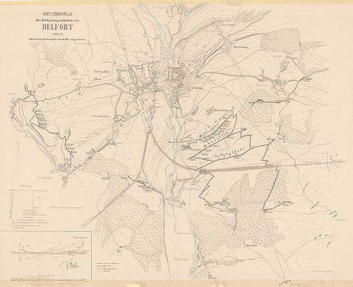
| Title | Situationsplan der Belagerungsarbeiten vor Belfort 1870. und 71. |
| Main title | Belfort (Fr.) és környéke vázlatos térképe. A város és erődítései alaprajzban. Védőművek. Az ostromló német haderők sánc- és futóárok-rendszere. Kilövőhelyek és lővonalak. |
147. Plan der Belagerungsarbeiten bei Strassburg 1870. [H IV c 294]
Institute and Museum of Military History •
H IV c (1841–1913)
•
H IV Újabbkori háborúk
•
H Háborúk
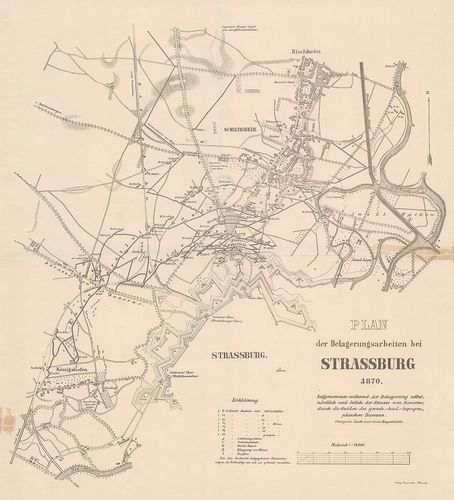
| Title | Plan der Belagerungsarbeiten bei Strassburg 1870. |
| Main title | Strassburg (Fr.) ostrom-művei, 1870. (Német–francia háború 1870–71.) Erődök, kiserődök, sáncok, futóárkok, útvonalak. |
148. Plan zur Belagerung von Strassburg [1870.] [H IV c 294/1]
Institute and Museum of Military History •
H IV c (1841–1913)
•
H IV Újabbkori háborúk
•
H Háborúk
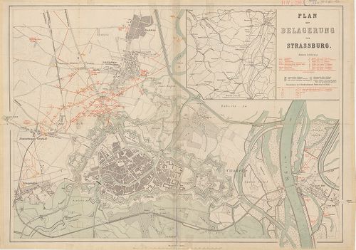
| Title | Plan zur Belagerung von Strassburg [1870.] |
| Main title | Mt.: [Srassburg és tágabb környékének térképe.]Strasbourg: ütegállások a város előterében 1870-ben. Város és vár alaprajzban a német–francia háborúban. |
149. [Gefechtsfeld von -Saarbrücken-Spichern] [H IV c 295]
Institute and Museum of Military History •
H IV c (1841–1913)
•
H IV Újabbkori háborúk
•
H Háborúk
| Title | [Gefechtsfeld von -Saarbrücken-Spichern] |
| Main title | A Saarbrücken (No.) – Spichern (Fr.) közötti hadszíntér. (Német–francia háború 1870–71.) |
150. [Gefechtsfeld von Mars la Tour, Vionville] [H IV c 296]
Institute and Museum of Military History •
H IV c (1841–1913)
•
H IV Újabbkori háborúk
•
H Háborúk
| Title | [Gefechtsfeld von Mars la Tour, Vionville] |
| Main title | A Mars la Tour – Vionville (Fr.) közötti hadszíntér. (Német–francia háború 1870–71.) |
151. Angriff der 1. Garde-Brigade auf St. Privat in der Schlacht ... [H IV c 296/1]
Institute and Museum of Military History •
H IV c (1841–1913)
•
H IV Újabbkori háborúk
•
H Háborúk
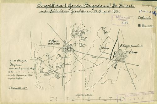
| Title | Angriff der 1. Garde-Brigade auf St. Privat in der Schlacht von Gravelotte am 18. August 1870. |
| Main title | A St. Privat elleni támadás a gravelottei (Fr.) csatában 1870. (Német–francia háború 1870–71.) Hadállások, hadmozdulatok. Útvonalak. |
152. Vorgehen des 33. Regiments in der Schlacht von Gravelotte. [H IV c 296/2]
Institute and Museum of Military History •
H IV c (1841–1913)
•
H IV Újabbkori háborúk
•
H Háborúk
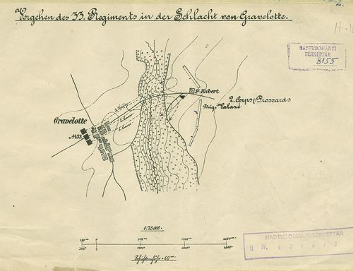
| Title | Vorgehen des 33. Regiments in der Schlacht von Gravelotte. |
| Main title | A gravelottei (Fr.) csata 1870. (Német–francia háború 1870–71.) A 33. sz. német ezred előnyomulása. Hadállások, hadmozdulatok. |
153. Schlacht bei Gravelotte–St. Privat. [H IV c 297]
Institute and Museum of Military History •
H IV c (1841–1913)
•
H IV Újabbkori háborúk
•
H Háborúk
| Title | Schlacht bei Gravelotte–St. Privat. |
| Main title | A Gravelotte–St. Privat (Fr.) közötti hadszíntér. (Német–francia háború 1870–71.) |
154. Karte zur Schlacht bei Gravelotte–St. Privat. [H IV c 297/1]
Institute and Museum of Military History •
H IV c (1841–1913)
•
H IV Újabbkori háborúk
•
H Háborúk
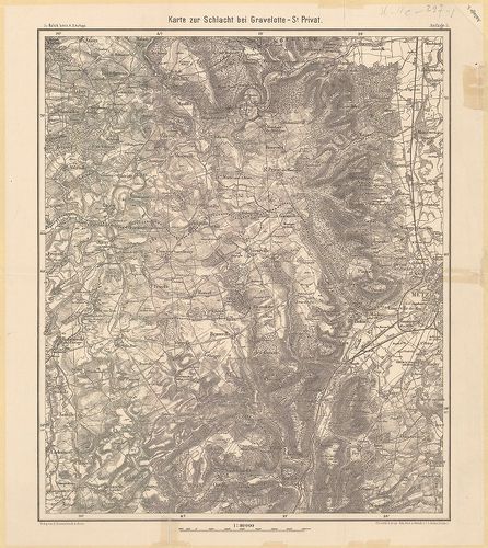
| Title | Karte zur Schlacht bei Gravelotte–St. Privat. |
| Main title | Gravelotte–St. Privat (Fr.) térsége 1870. (Német–francia háború 1870–71.) |
155. Zur Schlacht Gravelotte–St. Prviat. – Artillerie-Verwendung ... [H IV c 297/1a]
Institute and Museum of Military History •
H IV c (1841–1913)
•
H IV Újabbkori háborúk
•
H Háborúk
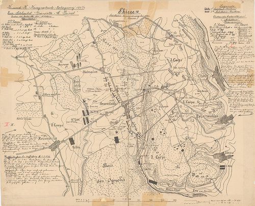
| Title | Zur Schlacht Gravelotte–St. Prviat. – Artillerie-Verwendung bei der 1. Armee. |
| Main title | A gravelotte-i (Fr.) csata helyszínrajza, 1870. (Német–francia háború 1870–71.) A tüzérség szerepe a hadrendben. Hadállások, felvonulási utak. |
156. [Metz (Fr.) és környéke.] Erődök alaprajzban. [H IV c 297/2]
Institute and Museum of Military History •
H IV c (1841–1913)
•
H IV Újabbkori háborúk
•
H Háborúk
| Title | [Metz (Fr.) és környéke.] Erődök alaprajzban. |
157. Ausschnitt aus dem Blatt Metz der Kriegskarte von Frankreich... [H IV c 297/3]
Institute and Museum of Military History •
H IV c (1841–1913)
•
H IV Újabbkori háborúk
•
H Háborúk
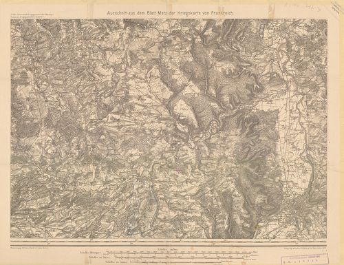
| Title | Ausschnitt aus dem Blatt Metz der Kriegskarte von Frankreich. |
| Main title | Metz (Fr.) északnyugati térsége Rouvrois-ig. |
158. Umgebung von Metz. (zu: Scherf: Kriegslehren I.) [H IV c 297/4]
Institute and Museum of Military History •
H IV c (1841–1913)
•
H IV Újabbkori háborúk
•
H Háborúk
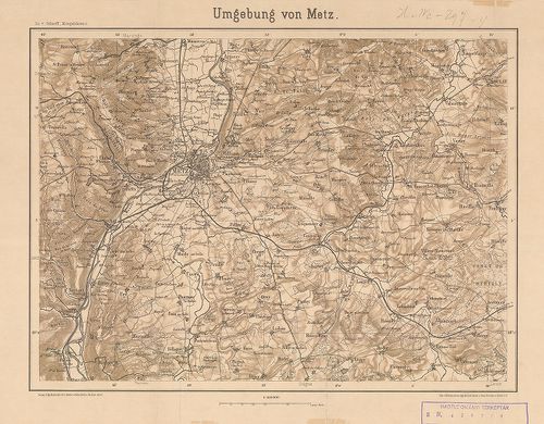
| Title | Umgebung von Metz. (zu: Scherf: Kriegslehren I.) |
| Main title | Metz (Fr.) és környéke. Utak, vasutak. |
159. Skizze 1 für Strategie F. 34. für den 14., 15. und 16. Augus... [H IV c 297/6]
Institute and Museum of Military History •
H IV c (1841–1913)
•
H IV Újabbkori háborúk
•
H Háborúk
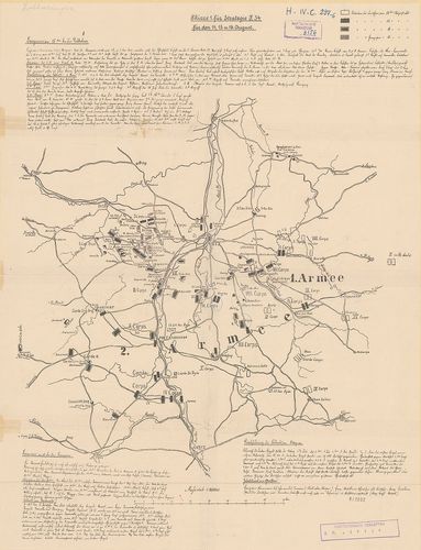
| Title | Skizze 1 für Strategie F. 34. für den 14., 15. und 16. August. |
| Main title | A Metz (Fr.) körüli harcok vázlatos helyszínrajza, 1870. Német és francia hadállások, hadmozdulatok. Útvonalak. A harcok részletes ismertetése. |
160. Plan der Gefechtsfelder der 2ten Garde Infanterie-Division a... [H IV c 302]
Institute and Museum of Military History •
H IV c (1841–1913)
•
H IV Újabbkori háborúk
•
H Háborúk
| Title | Plan der Gefechtsfelder der 2ten Garde Infanterie-Division am 30-ten October und 21-ten December 1870. [bei le Bourget] |
| Main title | A le Bourget (Parizs) környéki hadszíntér 1870. (Német–francia háború 1870–71.) |
161. Operationen der II. Armee und der Armee-Abtheilung des Gross... [H IV c 303]
Institute and Museum of Military History •
H IV c (1841–1913)
•
H IV Újabbkori háborúk
•
H Háborúk
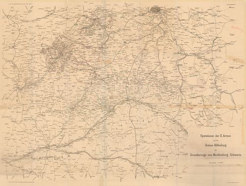
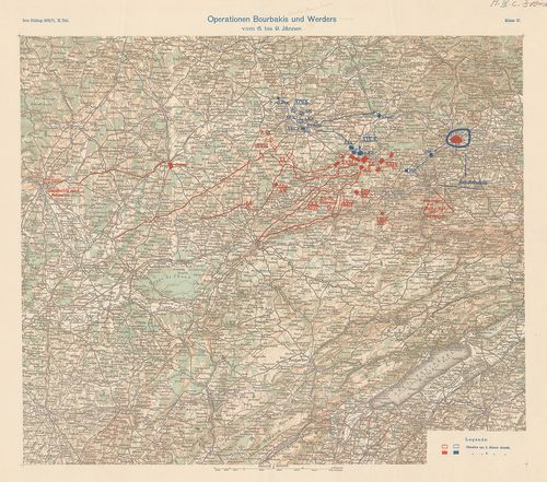
| Title | Operationen der II. Armee und der Armee-Abtheilung des Grossherzogs von Mecklenburg-Schwerin. (zu: F. Hoenig: Volkskrieg an der Loire 1870. I. Uebersichtskarte 2.) |
| Main title | A német–francia háború színtere Páris-Bourges, Alençon-Nogent (Fr.) között, 1870–71. |
162. „Die Stellung von Kadenbronn 1870.” [H IV c 304]
Institute and Museum of Military History •
H IV c (1841–1913)
•
H IV Újabbkori háborúk
•
H Háborúk
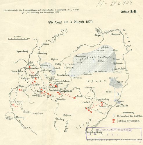
| Title | „Die Stellung von Kadenbronn 1870.” |
| Main title | Skizze: 44 Die Lage am 3. August 1870. |
| Subject | Skizze: 45. Die Stellung von Kadenbronn. (Fr.) |
163. Situationsplan über die Batterien, Schützengräben etc. vor N... [H IV c 305]
Institute and Museum of Military History •
H IV c (1841–1913)
•
H IV Újabbkori háborúk
•
H Háborúk
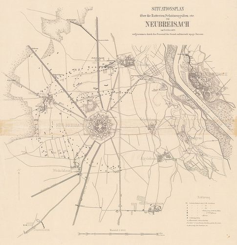
| Title | Situationsplan über die Batterien, Schützengräben etc. vor Neubreisach im October 1870. |
| Main title | Neubreisach (Neubrisach, Fr.) és környékének vázlatos helyszínrajza. (Német–francia háború, 1870–71.) A város és erődei alaprajzban. (A Rajna nyugati partján.) Ágyúállások, sáncok, lövészárkok. Útvonalak. |
164. Kriegs-Karte 1870. (Zur Allgem. Illustrierten Zeitung „Ueber... [H IV c 305/1]
Institute and Museum of Military History •
H IV c (1841–1913)
•
H IV Újabbkori háborúk
•
H Háborúk
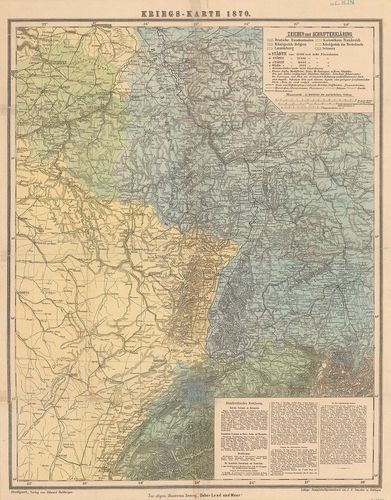
| Title | Kriegs-Karte 1870. (Zur Allgem. Illustrierten Zeitung „Ueber Land und Meer.”) |
| Main title | A német–francia háború színterének és a szomszéd államok egy részének áttekintő térképe (1870–71.). |
165. Der deutsch-französische Krieg 1870–71. [H IV c 305/5]
Institute and Museum of Military History •
H IV c (1841–1913)
•
H IV Újabbkori háborúk
•
H Háborúk
| Title | Der deutsch-französische Krieg 1870–71. |
| Main title | A német–francia háború 1870–71. térképei. |
166. Az 1870. évi német–francia háború története. I.–II. [H IV c 305/6]
Institute and Museum of Military History •
H IV c (1841–1913)
•
H IV Újabbkori háborúk
•
H Háborúk
| Title | Az 1870. évi német–francia háború története. I.–II. |
167. Az 1870–71. háború [Franciaországban.] [H IV c 305/9]
Institute and Museum of Military History •
H IV c (1841–1913)
•
H IV Újabbkori háborúk
•
H Háborúk
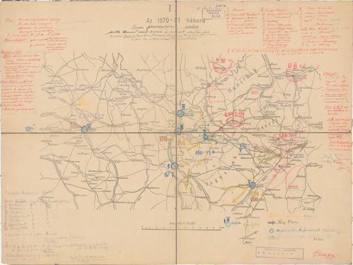
| Title | Az 1870–71. háború [Franciaországban.] |
| Main title | A háború vázlatos helyszínrajza annak különböző szakaszaiban. Sedan és Strassburg (Strasbourg, Fr.) térségében. |
168. Uebersichtskarte der Eisenbahnen und Telegraphenlinien [Fran... [H IV c 306]
Institute and Museum of Military History •
H IV c (1841–1913)
•
H IV Újabbkori háborúk
•
H Háborúk
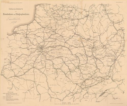
| Title | Uebersichtskarte der Eisenbahnen und Telegraphenlinien [Frankreich 1870.] |
| Main title | A német–francia háború alatt üzemben levő vasút és sürgönyvonalak térképe Franciaországban, 1870–71. (zu: F. Hoenig: Volkskrieg an der Loire. 1871. I. Uebersichtskarte 3.) |
169. Schlacht bei Woerth. [H IV c 308]
Institute and Museum of Military History •
H IV c (1841–1913)
•
H IV Újabbkori háborúk
•
H Háborúk
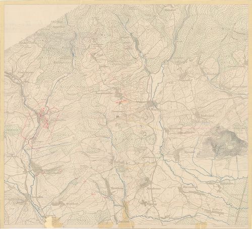
| Title | Schlacht bei Woerth. |
| Main title | A Woerth sur Sauer-i (Fr.) csata helyszíne, Alsó-Elszász, 1870. (Német–francia háború 1870–71.) |
170. Plan zur Schlacht von Wörth, 2 tl.: 1. Gefechtslage um 1 Uhr... [H IV c 308/1]
Institute and Museum of Military History •
H IV c (1841–1913)
•
H IV Újabbkori háborúk
•
H Háborúk
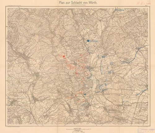
| Title | Plan zur Schlacht von Wörth, 2 tl.: 1. Gefechtslage um 1 Uhr 20 Minute. – 2. Gefechtslage um 3 Uhr 45 Minute. |
| Main title | Woerth sur Sauer (Fr.) melletti csata hadműveleti térképe (Német–francia háború, 1870–71.) Hadállások, hadmozdulatok. |
171. [Metz (Fr.) és környéke] [H IV c 310]
Institute and Museum of Military History •
H IV c (1841–1913)
•
H IV Újabbkori háborúk
•
H Háborúk
| Title | [Metz (Fr.) és környéke] |
| Main title | (Német–francia háború, 1870–71.) (Zu: Griepenkerl: Taktische Unterrischtsbriefe. 2. Aufl.) |
172. Carte des environs de Metz… pour servir a l’Intelligence du ... [H IV c 310/6]
Institute and Museum of Military History •
H IV c (1841–1913)
•
H IV Újabbkori háborúk
•
H Háborúk
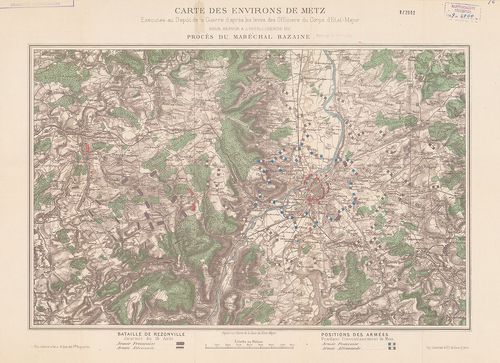
| Title | Carte des environs de Metz… pour servir a l’Intelligence du proces du Maréchal Bazaine… |
| Main title | A rezonvillei csata és Metz (Fr.) körülzárásának helyszínrajza, 1871. (Német–francia háború 1870–71.) Hadállások, útvonalak. (François Achille Bazaine francia tábornagy hazaárulási perének anyagához.) |
173. Plan zur Schlacht bei Beaune le Rolande am 28-ten November [... [H IV c 310/7]
Institute and Museum of Military History •
H IV c (1841–1913)
•
H IV Újabbkori háborúk
•
H Háborúk
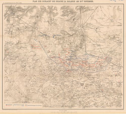
| Title | Plan zur Schlacht bei Beaune le Rolande am 28-ten November [1870.] |
| Main title | A Beaune le Rolande (Fr.) melletti csata helyszínrajza 1870. (Német–francia háború 1870–71.) Hadállások, súlypontok, útvonalak. (zu: Hoenig: Volkskrieg an der Loire 1870. II. 2. Aufl.) |
174. Plan zu den Nachtgefechten in der Schlacht an der Lisaine, a... [H IV c 310/10]
Institute and Museum of Military History •
H IV c (1841–1913)
•
H IV Újabbkori háborúk
•
H Háborúk
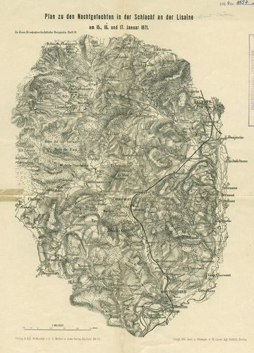
| Title | Plan zu den Nachtgefechten in der Schlacht an der Lisaine, am 15., 16. und 17. Januar 1871. |
| Main title | A Lisaine (Fr.) melletti csata (Haut-Saone) és környékének helyszíne 1871. (Német–francia háború 1870–71.)(zu: Kunz: Kriegsgeschichtliche Beispiele. H. III.) |
175. Plan zu den Nachtgefechten von le Mans, am 9ten 10ten, 11ten... [H IV c 310/11]
Institute and Museum of Military History •
H IV c (1841–1913)
•
H IV Újabbkori háborúk
•
H Háborúk
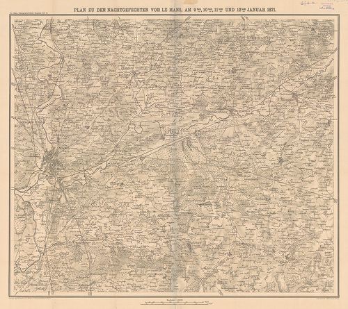
| Title | Plan zu den Nachtgefechten von le Mans, am 9ten 10ten, 11ten und 12ten Januar 1871. |
| Main title | Le Mans (Fr.) 1871. január 9–10–11–12-i éjszakai ütközet helyszínrajza 1897 körül. (Zu: Kunz, Kriegsgeschichtliche Beispiele Heft III.) |
176. Taktik-Studie. Die Schlacht bei Le Mans am 10., 11., 12., 1.... [H IV c 310/12]
Institute and Museum of Military History •
H IV c (1841–1913)
•
H IV Újabbkori háborúk
•
H Háborúk
| Title | Taktik-Studie. Die Schlacht bei Le Mans am 10., 11., 12., 1. 1871. |
| Main title | 9 mell. |
| Subject | 1. Situation der 2. Armee am 10. Jänner. (A 2. hadsereg helyz. jan. 10-én) Le Mans. |
177. General-Karte von Europa, – Generalkarte des russisch-türkis... [H IV c 311]
Institute and Museum of Military History •
H IV c (1841–1913)
•
H IV Újabbkori háborúk
•
H Háborúk
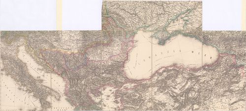
| Title | General-Karte von Europa, – Generalkarte des russisch-türkischen Kriegsschauplatzes in Europa und Kaukasien. |
| Main title | Az európai és kaukázusi orosz–török hadszíntér áttekintő térképe. Scheda: Generalkarte von Europa, 1845-1847. XIV., XVIII., XIX., XX. sz. 1apjain. |
178. [Plewna (Pleven, Bulg.) és környéke 1877–1878] [H IV c 311/4]
Institute and Museum of Military History •
H IV c (1841–1913)
•
H IV Újabbkori háborúk
•
H Háborúk
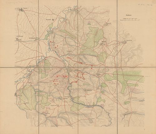
| Title | [Plewna (Pleven, Bulg.) és környéke 1877–1878] |
| Main title | (Orosz–török háború 1877–78.) Sáncok, futóárkok, kiserődök. |
179. Stellung des Plewna-Lowtscha Detachements im 4-ten Blockade ... [H IV c 311/4a]
Institute and Museum of Military History •
H IV c (1841–1913)
•
H IV Újabbkori háborúk
•
H Háborúk
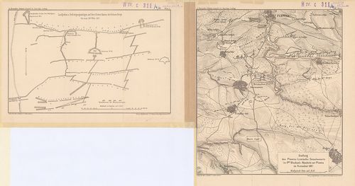
| Title | Stellung des Plewna-Lowtscha Detachements im 4-ten Blockade Abschnitt vor Plewna im November 1887 Plan 1. |
| Main title | 2.: Laufgräben und Befestigungsanlagen auf dem Ersten Kamm der Grünen berge bis zum 20ten Nov. 1877.A Plevna (Pleven, Bulg.) melletti állások 1877. (Orosz–török háború 1877–78.) Sáncok, futóárkok, kiserődök. (zu: Kuropatkin-Krahmer: Krieg 1877/78. Neue Folge. 2. Aufl. Plan. 1–2.) |
180. Die Donau–Uebergänge bei Braila–Matschin und Giurgievo–Rusts... [H IV c 311/5]
Institute and Museum of Military History •
H IV c (1841–1913)
•
H IV Újabbkori háborúk
•
H Háborúk
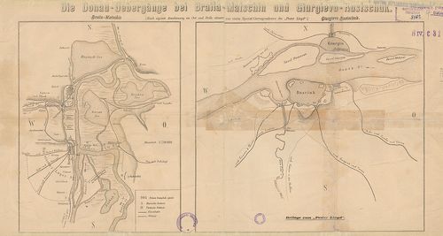
| Title | Die Donau–Uebergänge bei Braila–Matschin und Giurgievo–Rustschuk. 2 tk. egy lapon 1. Braula–Matschin (Macin, Rom.) |
| Main title | 2. Giurgievo (Rom.)–Rustschuk (Rusze, Bulg.) |
| Subject | Dunai átkelőhelyek Brailanál és Giurgievonál. (Orosz–török háború 1877–78.) 2 térk. egy lapon. Táborhelyek, hadállások, erődítések. Útvonalak. (Beil. zum Pester Lloyd.) |
181. Zweite Schlacht bei Plevna (Pleven) am 18. [30.] Juli 1877. ... [H IV c 311/6]
Institute and Museum of Military History •
H IV c (1841–1913)
•
H IV Újabbkori háborúk
•
H Háborúk
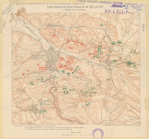
| Title | Zweite Schlacht bei Plevna (Pleven) am 18. [30.] Juli 1877. Situation zka 4h nachmittags. |
| Main title | A pleveni (Bulg.) csata helyszínrajza 1877. (Orosz–török háború 1877–78.) hadállások, hadmozdulatok. Útvonalak. Magyarázat. (Zum Werke „Der russisch–türkische Krieg 1877–78. Beil. 44. III. Band.) |
182. Zweite Schlacht bei Plevna (Pleven) Situation bei Tagesanbru... [H IV c 311/7]
Institute and Museum of Military History •
H IV c (1841–1913)
•
H IV Újabbkori háborúk
•
H Háborúk
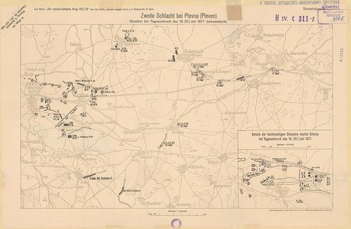
| Title | Zweite Schlacht bei Plevna (Pleven) Situation bei Tagesanbruch des 19. [31] Juli 1877. |
| Main title | Mt.: Details der beiderseitigen Situation nächts Grivica bei Tagesanbruch des 19. (31.) juli 1877. (A helyzet Grivicanál.)A második pleveni (Bulg.) csata helyszínrajza 1877. (Orosz–török háború 1877–78. (Hadállások, hadmozdulatok. Útvonalak. (Zum Werke „Der russisch-türkische Krieg 1877–78. Beil. 48. III. Band.) |
183. Südosten skizze 2., Herzegovina Montenegro. Montenegro und H... [H IV c 312/1]
Institute and Museum of Military History •
H IV c (1841–1913)
•
H IV Újabbkori háborúk
•
H Háborúk
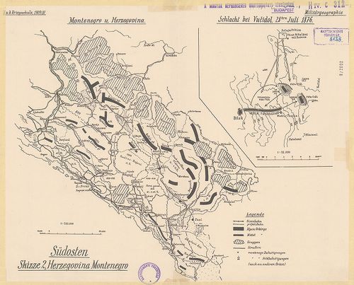
| Title | Südosten skizze 2., Herzegovina Montenegro. Montenegro und Herzegovina. 1876. |
| Main title | Mt.: Schlacht bei Vučidol 28ten Juli 1876. |
| Subject | (A vučidoli csata térképe.) |
184. Die Befestigungen von Adrianopel 1877/78. [H IV c 312/4]
Institute and Museum of Military History •
H IV c (1841–1913)
•
H IV Újabbkori háborúk
•
H Háborúk
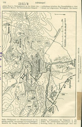
| Title | Die Befestigungen von Adrianopel 1877/78. |
| Main title | Adrianopel (Edirne, Tör.) és környéke a Marica partján. (Orosz–török háború 1877–78.) A város védőművei és katonai berendezései. Útvonalak. |
185. Plan der Stadt Lowtscha mit Umgegend. [H IV c 312/5]
Institute and Museum of Military History •
H IV c (1841–1913)
•
H IV Újabbkori háborúk
•
H Háborúk
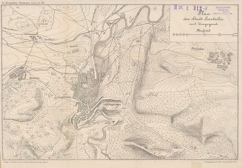
| Title | Plan der Stadt Lowtscha mit Umgegend. |
| Main title | Lovecs város és környéke, Bulgária 1877. (Orosz–török háború, 1877–78.) A város alaprajzban az Osma (Oszin) folyó partján. Útvonalak. (zu: Kuropatkin – Krahmer: Krieg von 1877.) |
186. Generalkarte von Mittel-Europa. [H IV c 313]
Institute and Museum of Military History •
H IV c (1841–1913)
•
H IV Újabbkori háborúk
•
H Háborúk
| Title | Generalkarte von Mittel-Europa. |
| Main title | Közép-Európa áttekintő térképének 7., 8., 11. és 12. lapja mint az orosz–török hadszíntér térképe. |
187. General-Karte der Europaeischen Türkei und des Königreiches ... [H IV c 314]
Institute and Museum of Military History •
H IV c (1841–1913)
•
H IV Újabbkori háborúk
•
H Háborúk
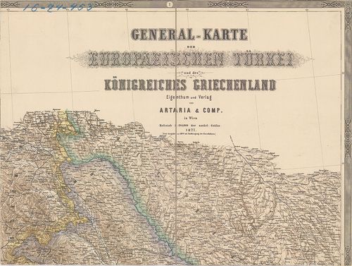
| Title | General-Karte der Europaeischen Türkei und des Königreiches Griechenland. |
| Main title | A Balkán áttekintő térképe 1877-ben. |
188. Kriegs-Karte der Europäischen Türkei… und den angrenzenden G... [H IV c 315]
Institute and Museum of Military History •
H IV c (1841–1913)
•
H IV Újabbkori háborúk
•
H Háborúk
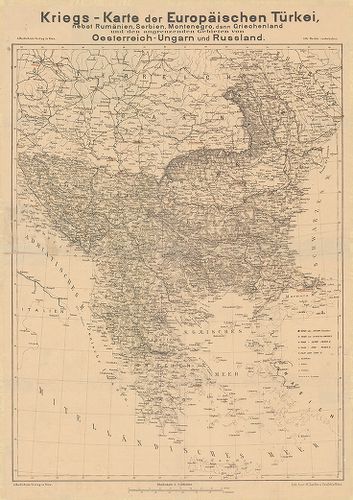
| Title | Kriegs-Karte der Europäischen Türkei… und den angrenzenden Gebieten von Oesterreich–Ungarn und Russland. |
| Main title | Európai Törökország háborús térképe. A balkáni államok és északi szomszédaik. (Orosz–török háború 1877–78. Csak helyszínrajz.) |
189. Der russisch-türkische Krieg 1877–78. auf der Balkanhalbinse... [H IV c 318]
Institute and Museum of Military History •
H IV c (1841–1913)
•
H IV Újabbkori háborúk
•
H Háborúk
| Title | Der russisch-türkische Krieg 1877–78. auf der Balkanhalbinsel. I. Teil. |
| Main title | A balkáni orosz–török háború leírása és térképei, vázlatai, hadrendje. |
190. Der russisch-türkische Krieg 1877–78. auf der Balkanhalbinse... [H IV c 319]
Institute and Museum of Military History •
H IV c (1841–1913)
•
H IV Újabbkori háborúk
•
H Háborúk
| Title | Der russisch-türkische Krieg 1877–78. auf der Balkanhalbinsel. II Teil. |
| Main title | Az orosz–török háború 1877–78-ig a Balkán-félszigeten. |
191. Vojiste u szroszko-bulgarszkom ratu. [H IV c 320]
Institute and Museum of Military History •
H IV c (1841–1913)
•
H IV Újabbkori háborúk
•
H Háborúk

| Title | Vojiste u szroszko-bulgarszkom ratu. |
| Main title | A szerb–bolgár háború (1885 november) áttekintő vázlata. Megerősített helyek, hadállások, útvonalak. |
192. Türkisch-Russischer Kriegsschauplatz. [H IV c 320/2]
Institute and Museum of Military History •
H IV c (1841–1913)
•
H IV Újabbkori háborúk
•
H Háborúk

| Title | Türkisch-Russischer Kriegsschauplatz. |
| Main title | 2 mt.: 1. Der Bosporus. (A Boszporusz) 2. Russisch–türkisches Grenzgebiet in Armenien, (Orosz–török határ Örményországnál.) |
| Subject | Az orosz–török hadszíntér áttekintő térképe (1877–78.), Szerbiától a Kaukázusig, Chersontól Ciprusig. Hadállások, szárazon és vizen. Tengeri távolságok. Orosz–török hadihajók. A Stielers Hand-Atlas alapján. |
193. Plan der Umgegend der Stadt Plewna und des befestigten Lager... [H IV c 320/3]
Institute and Museum of Military History •
H IV c (1841–1913)
•
H IV Újabbkori háborúk
•
H Háborúk

| Title | Plan der Umgegend der Stadt Plewna und des befestigten Lagers der Türken am 7. September 1877. |
| Main title | Pleven (Bulg.) város környéke, 1877. (Orosz–török háború 1877–78.) Megerősített török táborhelyek. Útvonalak. (zu: Kuropatkin-Krahmer: Krieg von 1877.) |
194. Der russisch-türkische Krieg 1877–78. in Europa. [H IV c 320/4]
Institute and Museum of Military History •
H IV c (1841–1913)
•
H IV Újabbkori háborúk
•
H Háborúk
| Title | Der russisch-türkische Krieg 1877–78. in Europa. |
| Main title | Az orosz–török háború 1877–78. |
195. Polozsaji oko Trna i Vrapcse. [1885. nov. 15.] [H IV c 321]
Institute and Museum of Military History •
H IV c (1841–1913)
•
H IV Újabbkori háborúk
•
H Háborúk

| Title | Polozsaji oko Trna i Vrapcse. [1885. nov. 15.] |
| Main title | Hadállások Tran és Vrabca (Bulg.) mellett. (Szerb–bolgár háború, 1885.) |
196. Zapadna okolina Szlivnice. Szituacija 5. nov. u. 12. cs. na ... [H IV c 322]
Institute and Museum of Military History •
H IV c (1841–1913)
•
H IV Újabbkori háborúk
•
H Háborúk

| Title | Zapadna okolina Szlivnice. Szituacija 5. nov. u. 12. cs. na podne. [1885.] |
| Main title | A szlivnicai (Bulg.) csata helyszínrajza a várostól nyugatra 1885. nov. 5–12. (Bolgár–szerb háború 1885.) Hadállások, hadmozdulatok. |
197. Kroki okoline Pirota. [H IV c 323]
Institute and Museum of Military History •
H IV c (1841–1913)
•
H IV Újabbkori háborúk
•
H Háborúk

| Title | Kroki okoline Pirota. |
| Main title | A pirati csata helyszínrajza. (Szerb–bolgár háború 1885. nov. 14. és 15-én.) Hadállások, hadmozdulatok. |
198. Plan Vidinszke tvrdtyave … po podne 13. nov. 1885. g. [H IV c 324]
Institute and Museum of Military History •
H IV c (1841–1913)
•
H IV Újabbkori háborúk
•
H Háborúk

| Title | Plan Vidinszke tvrdtyave … po podne 13. nov. 1885. g. |
| Main title | Vidin (Bulg.) és környéke. Város és erődei alaprajzban 1885. |
199. Grazsdanszkaja vojna v. SzSA. 1861–1865 gg. [H IV c 329]
Institute and Museum of Military History •
H IV c (1841–1913)
•
H IV Újabbkori háborúk
•
H Háborúk
| Title | Grazsdanszkaja vojna v. SzSA. 1861–1865 gg. |
| Main title | Mt.: SZSA. k. nacsalu grazsdanszkoj vojnii. (Az Egyesült Államok a polgárháború kezdetén.)Az Észak-Amerikai Egyesült Államok polgárháborújának térképe 1861–1865. Változó határok. Az ellenfelek hadmozdulatai szárazon és vizen. Csatahelyek. |
200. Karte des Amerikanisch-Spanischen Kriegsschauplatzes. – Amer... [H IV c 330]
Institute and Museum of Military History •
H IV c (1841–1913)
•
H IV Újabbkori háborúk
•
H Háborúk

| Title | Karte des Amerikanisch-Spanischen Kriegsschauplatzes. – Amerikanisch-Spanischer Kriegsschauplatz. |
| Main title | 7 mt.: 1. Die Insel Cuba. (Kuba szg.) 2. Der Nordatlant. Ocean. (Észak-atlanti-óceán.) 3. Puerto Rico. 4. Bermuda 5. Habana und Umgegend. (La Habama, (Kuba) és környéke.) 6. Habana (La Habama, Kuba.) 7. Einfahrt und Hafen von New York. (New York kikötője.)Az észak-amerikai–spanyol háború térképe 1898-ban. |