101. Kriegsschauplatz Böhmen, Mähren, Schlesien und Nordost-Deuts... [H IV c 235/2]
Institute and Museum of Military History •
H IV c (1841–1913)
•
H IV Újabbkori háborúk
•
H Háborúk
| Title | Kriegsschauplatz Böhmen, Mähren, Schlesien und Nordost-Deutschland. |
| Main title | Cseh- és Morvaország, Szilézia és Északkelet-Németország mint az 1866. évi porosz–osztrák háború hadműveleteinek színtere. Megerősített helyek, felvonulási utak, távolsági és geológiai adatok a térképben. |
102. Gefechtsfeld von Nachod, Skalitz und Schweinschädel. [H IV c 235/3]
Institute and Museum of Military History •
H IV c (1841–1913)
•
H IV Újabbkori háborúk
•
H Háborúk
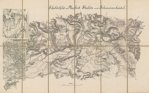
| Title | Gefechtsfeld von Nachod, Skalitz und Schweinschädel. |
| Main title | 2 Mt.: 1. [Hrade-Techlowitz] 2. Übersichts-Plan zum Gefecht von. Nachod. (Náchod környéki csaták.)A Náchod, Skalitz (Česka Skalica) és Schweinschädel (Sviništ’any, Cs.) (1866. évi porosz–osztrák háború.) Útvonalak. |
103. Gefecht von Trautenau am 27. Juni und von Trautenau – Soor a... [H IV c 236/1]
Institute and Museum of Military History •
H IV c (1841–1913)
•
H IV Újabbkori háborúk
•
H Háborúk
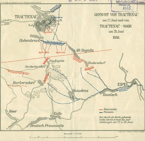
| Title | Gefecht von Trautenau am 27. Juni und von Trautenau – Soor am 28. Juni 1866. |
| Main title | A trautenaui (Trutnov) és a trautenau–soori ütközet vázlatos helyszínrajza 1866. (Csehország. Porosz–osztrák háború.) hadállások, hadmozdulatok. |
104. Das Schlachtfeld von Königgrätz [3. Juli, 1866.] [H IV c 237]
Institute and Museum of Military History •
H IV c (1841–1913)
•
H IV Újabbkori háborúk
•
H Háborúk
| Title | Das Schlachtfeld von Königgrätz [3. Juli, 1866.] |
| Main title | A königgrätzi (Hradec Králové) csata helyszíne 1866. (Csehország. Porosz–osztrák háború.) |
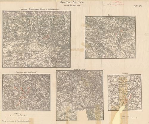
105. Anleitung zur Verfassung von Situations und Rekognoszierungs... [H IV c 237/2]
Institute and Museum of Military History •
H IV c (1841–1913)
•
H IV Újabbkori háborúk
•
H Háborúk
| Title | Anleitung zur Verfassung von Situations und Rekognoszierungs. Skizzen [1866.] |
| Main title | A Königgrätz (Hradec Králové) továbbá a Jičin, Schweinschädel, (Sviništ’any) Skalitz (Česka Skalice) Trautenau (Trutnov) és Wysokow melletti csaták tereptani és harcászati kiértékeléséhez készült látképes terepvázlatok, mint tansegédlet. |
106. Königgrätz. Kurze Darstellung der Schlacht am 3. Juli 1866. [H IV c 237/4]
Institute and Museum of Military History •
H IV c (1841–1913)
•
H IV Újabbkori háborúk
•
H Háborúk
| Title | Königgrätz. Kurze Darstellung der Schlacht am 3. Juli 1866. |
| Main title | A königgrätzi (Hradec Králové, Cs.) csata részletes térképei. A „Königgrätz” c. mű térképmellékletei. |
107. Plan zu Schlacht von Königgrätz [H IV c 237/5]
Institute and Museum of Military History •
H IV c (1841–1913)
•
H IV Újabbkori háborúk
•
H Háborúk
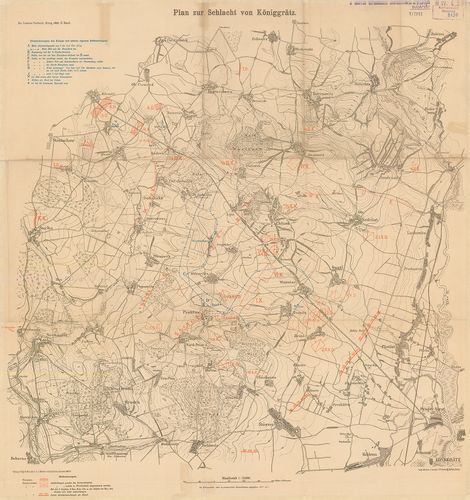
| Title | Plan zu Schlacht von Königgrätz |
| Main title | A königgrätzi (Hradec Králové, Cs.) csata helyszínrajza 1866. Porosz és osztrák hadállások, hadmozdulatok. I. Vilmos porosz király hadinaplójának részletei. |
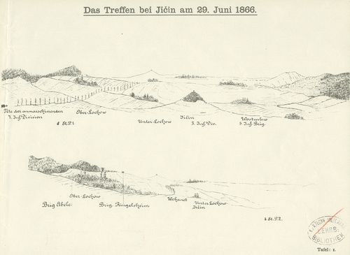
108. Plan des Gefechtsfeldes von Gitshen (den. 29.–Juni 1866.) [H IV c 237/6]
Institute and Museum of Military History •
H IV c (1841–1913)
•
H IV Újabbkori háborúk
•
H Háborúk
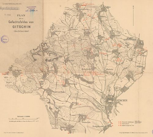
| Title | Plan des Gefechtsfeldes von Gitshen (den. 29.–Juni 1866.) |
| Main title | A gitsheni csata helyszínrajza 1866. Porosz, osztrák, szász hadállások hadmozdulatok. I. Vilmos porosz király hadinaplójának részletei |
109. Nordöstlicher Kriegsschauplatz 1866. [H IV c 237/7]
Institute and Museum of Military History •
H IV c (1841–1913)
•
H IV Újabbkori háborúk
•
H Háborúk
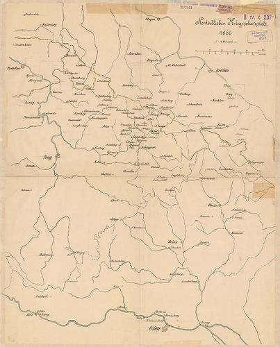
| Title | Nordöstlicher Kriegsschauplatz 1866. |
| Main title | Glogau – Wien – Prága – Troppau közötti térség. Csehország mint az 1866. évi porosz–osztrák háború színtere. |
110. Situation bei Chlum am 3. Juli 1866. gegen 2h30m nachmittags... [H IV c 238/8]
Institute and Museum of Military History •
H IV c (1841–1913)
•
H IV Újabbkori háborúk
•
H Háborúk
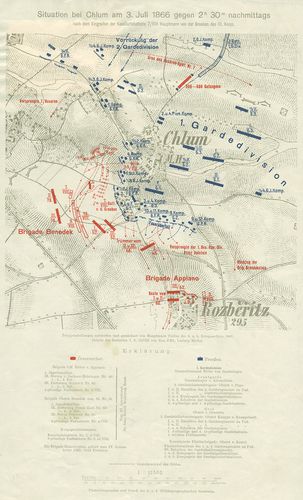
| Title | Situation bei Chlum am 3. Juli 1866. gegen 2h30m nachmittags… |
| Main title | A chlumi (Cs.) csata vázlatos helyszínrajza 1866. (Porosz–osztrák háború Csehországban.) Hadállások, hadmozdulatok. Útvonalak. |
111. Marsch-Routen Karte für die Armee-Corps und Cavallerie-Divis... [H IV c 238/16]
Institute and Museum of Military History •
H IV c (1841–1913)
•
H IV Újabbkori háborúk
•
H Háborúk
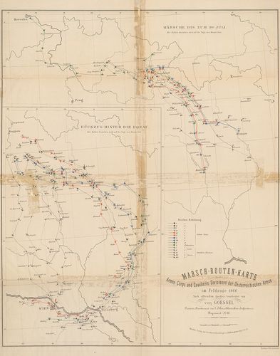
| Title | Marsch-Routen Karte für die Armee-Corps und Cavallerie-Divisionen der Oesterreichischen Armee im Feldzuge 1866. 1. Märsche bis zum 3ten Juli. 2. Rückzug hinter die Donak. |
| Main title | Menettérkép az osztrák hadtestek és lovashadosztályok számára az 1866. évi hadjáratban. Brünn és Königgrätz közötti térség. Visszavonulás a Duna vonala mögé. |
112. Der Feldzug 1866. in Böhmen bis einschliesslich der Schlacht... [H IV c 238/17]
Institute and Museum of Military History •
H IV c (1841–1913)
•
H IV Újabbkori háborúk
•
H Háborúk
| Title | Der Feldzug 1866. in Böhmen bis einschliesslich der Schlacht von Königrätz. |
| Main title | A csehországi hadjárat 1866-ban a königrätzi csatáig. |
113. Oesterreichs-Kämpfe im Jahre 1866. [H IV c 245]
Institute and Museum of Military History •
H IV c (1841–1913)
•
H IV Újabbkori háborúk
•
H Háborúk
| Title | Oesterreichs-Kämpfe im Jahre 1866. |
| Main title | Ausztria harcai 1866-ban a poroszokkal és az olaszokkal. |
114. Operations Karte des oberitalienischen Kriegsschauplatzes. N... [H IV c 247]
Institute and Museum of Military History •
H IV c (1841–1913)
•
H IV Újabbkori háborúk
•
H Háborúk
| Title | Operations Karte des oberitalienischen Kriegsschauplatzes. Nach den Neuesten Landesbeschreibungsmaterialien zusammengestellt. 1863. Generalkarte des Lombardisch-Venetianischen Königreiches… im Jahre 1838. c. térk.-re nyomva. |
| Main title | Az észak-olaszországi osztrák–olasz háború hadműveleti térképe. Megerősített helyek, hídfők, hadállások, útvonalak, átkelőhelyek. A Lombard-velencei királyság politikai felosztása. |
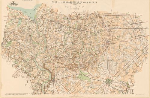
115. Schlacht von Custozza am 24. Juni 1866. [H IV c 249]
Institute and Museum of Military History •
H IV c (1841–1913)
•
H IV Újabbkori háborúk
•
H Háborúk
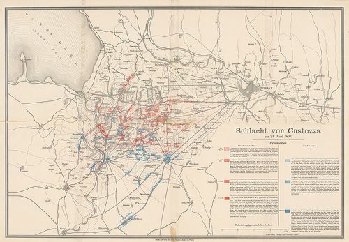
| Title | Schlacht von Custozza am 24. Juni 1866. |
| Main title | A custozzai (Ol.) csata helyszínrajza 1866. Olasz és osztrák hadállások, hadmozdulatok. Útvonalak. |
116. Karte zur Schlacht bei Solfererino 1859 und Custoza 1866. da... [H IV c 249/1a]
Institute and Museum of Military History •
H IV c (1841–1913)
•
H IV Újabbkori háborúk
•
H Háborúk
| Title | Karte zur Schlacht bei Solfererino 1859 und Custoza 1866. dann… |
| Main title | Mt.: Zum Gefecht bei Nogaredo-Versa. (Nogaredo-Versa-i ütközet) A solferinoi (1859) és a custozai (1866) csata térképe. |
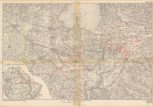
117. Karten-Skizze zu den Gefechten bei: Siehrow und Podol – Ošwi... [H IV c 249/1b]
Institute and Museum of Military History •
H IV c (1841–1913)
•
H IV Újabbkori háborúk
•
H Háborúk
| Title | Karten-Skizze zu den Gefechten bei: Siehrow und Podol – Ošwieçin – Trautenau und Burkerşdorf, Wysokow, Čerwena Hura, Skalitz und Schweinschädel, dann Jičin. |
| Main title | Podol-Ošwiecin-Trutnov-Sviništany- és Jičin melletti csaták térképe. |
118. Das k[aiserliche] k[önigliche] Linien Infanterie Regiment Nr... [H IV c 249/2]
Institute and Museum of Military History •
H IV c (1841–1913)
•
H IV Újabbkori háborúk
•
H Háborúk
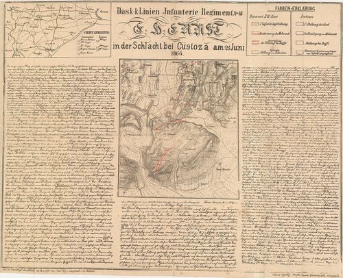
| Title | Das k[aiserliche] k[önigliche] Linien Infanterie Regiment Nr. 48. E[rz] H[erzog] Ernst in der Schlacht bei Custoza (Ol.) am 24. Juni 1866. |
| Main title | Mt.: [Verona (Ol.) környéke.]A cs. kir. Ernő főherceg 48. sz. gyalogezred a custozzai csatában 1866. Custozza és környéke az osztrák és olasz csapatok hadmozdulataival. Részletes ismertetés. A csata 30. évfordulójára 1896. |
119. Plan des Schlachtfeldes von Custoza am 24 Juni 1866. [H IV c 249/4]
Institute and Museum of Military History •
H IV c (1841–1913)
•
H IV Újabbkori háborúk
•
H Háborúk
| Title | Plan des Schlachtfeldes von Custoza am 24 Juni 1866. |
| Main title | A custozzai csatatér és környéke (Ol.). |
120. Plan des Schlachtfeldes von Custozza am 24. Juni 1866. („Zu ... [H IV c 250]
Institute and Museum of Military History •
H IV c (1841–1913)
•
H IV Újabbkori háborúk
•
H Háborúk
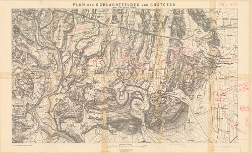
| Title | Plan des Schlachtfeldes von Custozza am 24. Juni 1866. („Zu Oberst von Mathes: Einige taktische Aufgaben”.) |
| Main title | A custozzai csata helyszínrajza (Ol.) 1866. Osztrák és olasz hadállások, hadmozdulatok kézzel bejelölve. |
121. Kampf um Custoza und Monte Torre nach 5h N. [M. (in der Schl... [H IV c 250/1]
Institute and Museum of Military History •
H IV c (1841–1913)
•
H IV Újabbkori háborúk
•
H Háborúk
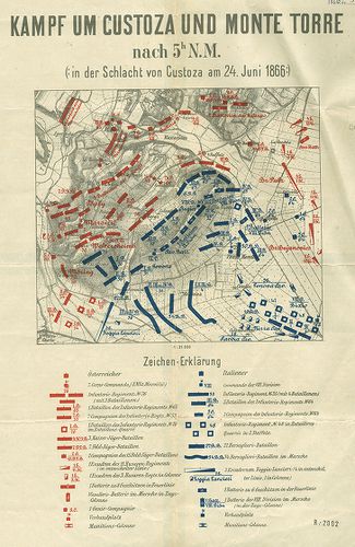
| Title | Kampf um Custoza und Monte Torre nach 5h N. [M. (in der Schlacht von Custoza am 24. Juni 1866.) |
| Main title | A custozzai csata helyszínrajza (Ol.) 1866. Osztrák és olasz hadállások. A csata története a térkép hátlapján. |
122. Skizzen zur orientirung über den Feldzug 1866 in Italien. (S... [H IV c 250/2]
Institute and Museum of Military History •
H IV c (1841–1913)
•
H IV Újabbkori háborúk
•
H Háborúk
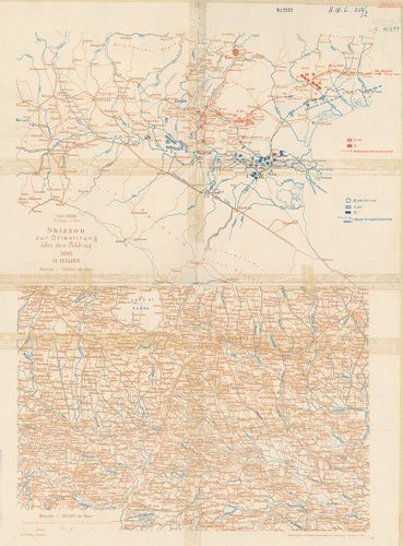
| Title | Skizzen zur orientirung über den Feldzug 1866 in Italien. (Skizze 6.) Taf. XXXIII. |
| Main title | Az olasz–osztrák háború hadállásai és hadmozdulatai Verona távolabbi térségében, 1866. |
123. Der Krieg 1866 in Italien und Südtirol. XI. Spezialkarte der... [H IV c 251/2]
Institute and Museum of Military History •
H IV c (1841–1913)
•
H IV Újabbkori háborúk
•
H Háborúk
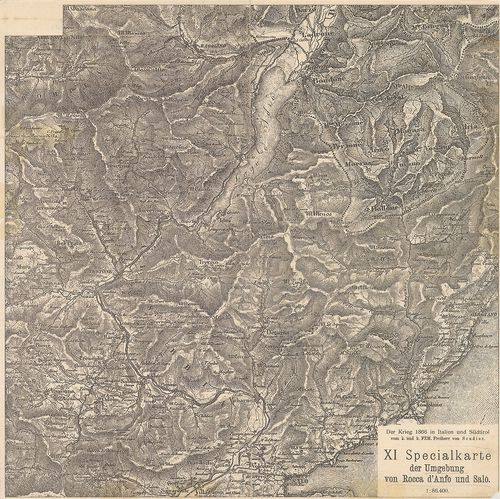
| Title | Der Krieg 1866 in Italien und Südtirol. XI. Spezialkarte der Umgebung von Rocca d’Anfo und Salo. |
| Main title | Rocca d’Anfo és Saló (Ol.) közötti térség az 1866. évi olaszországi hadjáratban. |
124. Der Krieg 1866 in Italien und Südtirol. XII. Specialkarte de... [H IV c 251/3]
Institute and Museum of Military History •
H IV c (1841–1913)
•
H IV Újabbkori háborúk
•
H Háborúk
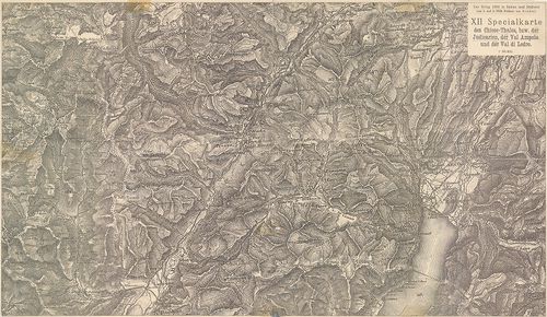
| Title | Der Krieg 1866 in Italien und Südtirol. XII. Specialkarte des Chiese-Thales bzw. der Judicarien, der Val Ampola und der Val di Ledro. |
| Main title | A Chiese-völgy, a Giudicariák, az Ampola és a Ledro-völgy (Ol.) térségének részletes térképe. (Olasz–osztrák háború 1866.) |
125. Angriff der Brigade Waldstätten… [1866.] [H IV c 252/2]
Institute and Museum of Military History •
H IV c (1841–1913)
•
H IV Újabbkori háborúk
•
H Háborúk
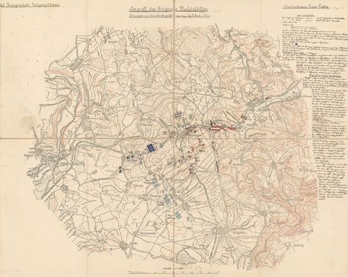
| Title | Angriff der Brigade Waldstätten… [1866.] |
| Main title | Náchod-Wysokow-Skalitz térségében lefolyt ütközet helyszínrajza, 1866. (Porosz–osztrák háború.) Hadállások, hadmozdulatok. A csata két mozzanata. A csata leírása, a tk. szélén. gótb. kézir. (Hadiiskolai dolgozat.) |
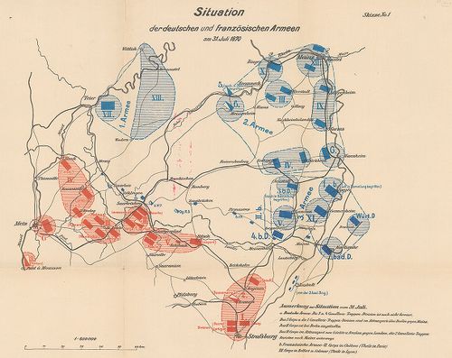
126. Topographische Karte der Umgebung von Metz. Die Kriegsoperat... [H IV c 259]
Institute and Museum of Military History •
H IV c (1841–1913)
•
H IV Újabbkori háborúk
•
H Háborúk
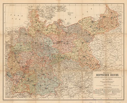
| Title | Topographische Karte der Umgebung von Metz. Die Kriegsoperationen um Metz im Jahre 1870. |
| Main title | Hátl.: Militär-Karte des Deutschen Reichs zur Übersicht des Quartier-Standes und der Landwehr-Inspektions-Bezirke vom 1 April 1890 ab. |
| Subject | Metz [Fr.] körüli csaták 1870. aug. 16., 18., 31.–szept. 1. és 1890-ben.A Német Birodalom katonai kerületi felügyelőség alakulatainak állomáshelyei 1890. április 1-jén. |
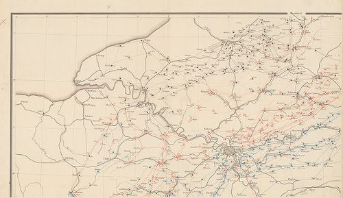
127. [Der Feldzug in Frankreich 1870 bis zur Schlacht bei Sedan.] [H IV c 260]
Institute and Museum of Military History •
H IV c (1841–1913)
•
H IV Újabbkori háborúk
•
H Háborúk
| Title | [Der Feldzug in Frankreich 1870 bis zur Schlacht bei Sedan.] |
| Main title | Franciaországi hadjárat, Sedan melletti csata térképei 1870-ben. |
128. [Der Feldzug in Frankreich 1870–71. II. Teil.] [H IV c 260/1]
Institute and Museum of Military History •
H IV c (1841–1913)
•
H IV Újabbkori háborúk
•
H Háborúk
| Title | [Der Feldzug in Frankreich 1870–71. II. Teil.] |
| Main title | Franciaországi hadjárat 1870–71-ben. |
129. Handtke’s Karte des Deutsch-Französischen Kriegsschauplatzes... [H IV c 261]
Institute and Museum of Military History •
H IV c (1841–1913)
•
H IV Újabbkori háborúk
•
H Háborúk
| Title | Handtke’s Karte des Deutsch-Französischen Kriegsschauplatzes. |
| Main title | A német–francia hadszíntér 1870. Német, francia, belga és holland határterületek. |
130. Deutsch-Französischer Kriegsschauplatz (Westlich von Paris N... [H IV c 262]
Institute and Museum of Military History •
H IV c (1841–1913)
•
H IV Újabbkori háborúk
•
H Háborúk
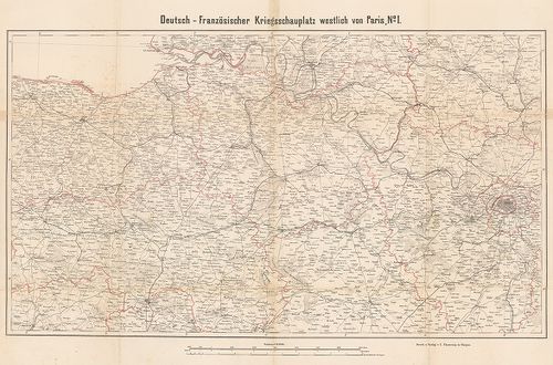
| Title | Deutsch-Französischer Kriegsschauplatz (Westlich von Paris No I–II.) |
| Main title | A német–francia háború hadszíntere Párizstól (Fr.) nyugatra 1870–71. |
131. Übersichtskarte von Nordost-Frankreich in den Jahren 1870–71... [H IV c 262/1]
Institute and Museum of Military History •
H IV c (1841–1913)
•
H IV Újabbkori háborúk
•
H Háborúk
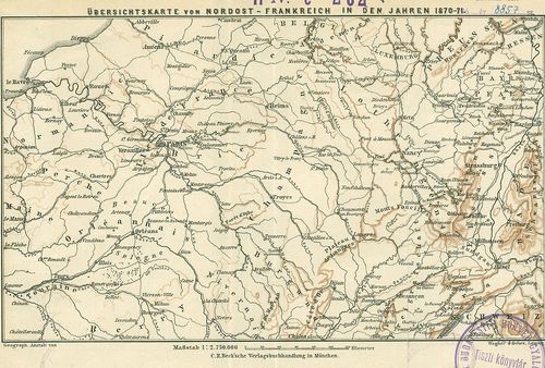
| Title | Übersichtskarte von Nordost-Frankreich in den Jahren 1870–71. |
| Main title | Északkelet-Franciaország áttekintő térképe. (Német–francia háború 1870–71.) |
132. Karte des Südöstlichen Kriegsschaupatzes. [H IV c 262/2]
Institute and Museum of Military History •
H IV c (1841–1913)
•
H IV Újabbkori háborúk
•
H Háborúk
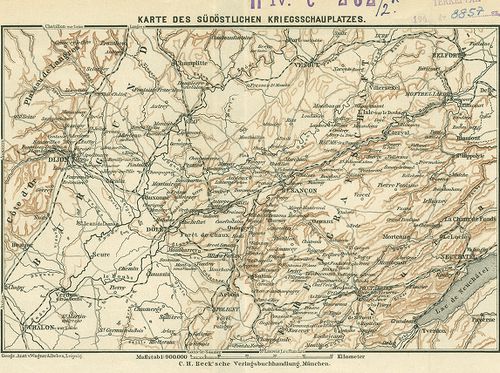
| Title | Karte des Südöstlichen Kriegsschaupatzes. |
| Main title | Délkelet-Franciaország térképe. (Német–francia háború 1870–71.) |
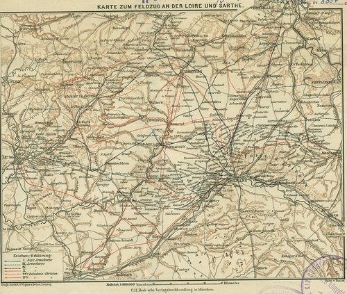
133. Karte zum Feldzug an der Loire und Sarthe. [H IV c 262/3]
Institute and Museum of Military History •
H IV c (1841–1913)
•
H IV Újabbkori háborúk
•
H Háborúk
| Title | Karte zum Feldzug an der Loire und Sarthe. |
| Main title | A Loire–Sarthe (Fr.) közötti hadjárat térképe. (Német–francia háború 1870–71.) A hadjárat útvonalai bejelölve. |
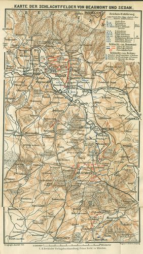
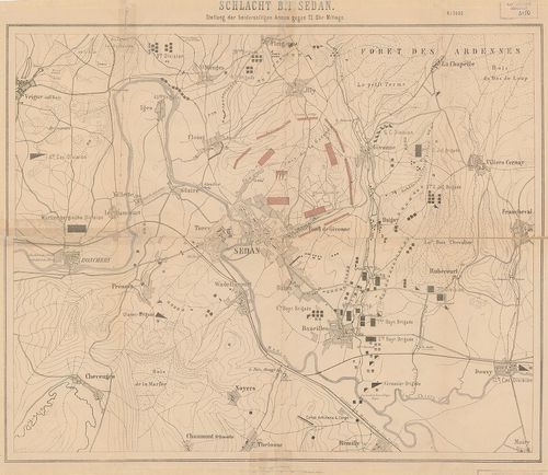
134. Karte der Schlachtfelder von Beaumont und Sedan. [H IV c 262/4]
Institute and Museum of Military History •
H IV c (1841–1913)
•
H IV Újabbkori háborúk
•
H Háborúk
| Title | Karte der Schlachtfelder von Beaumont und Sedan. |
| Main title | A beamonti és sedani (Fr.) csataterek térképe. (Német–francia háború 1870–71.) |
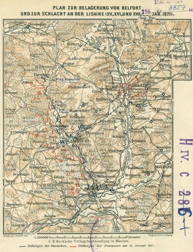
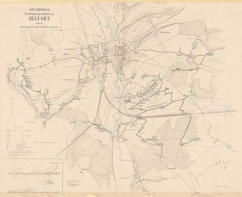
135. Plan zur Belagerung von Belfort und zur Schlacht an der Lisa... [H IV c 262/5]
Institute and Museum of Military History •
H IV c (1841–1913)
•
H IV Újabbkori háborúk
•
H Háborúk
| Title | Plan zur Belagerung von Belfort und zur Schlacht an der Lisaine (XV., XVI. und XVII. Jan. 1871.) |
| Main title | Belfort (Fr.) ostroma és a Lisaine melletti csata helyszínrajza 1871. (Német–francia háború 1870–71.) Hadállások. Útvonalak. |
136. Der deutsch-französische Kriegsschauplatz [H IV c 263/1]
Institute and Museum of Military History •
H IV c (1841–1913)
•
H IV Újabbkori háborúk
•
H Háborúk
| Title | Der deutsch-französische Kriegsschauplatz |
| Main title | A német–francia hadszíntér 1870. Német, francia, belga és holland határterületek. Szín. Országok szerint. |
137. [Siegeszug der 22. Division in Frankreich, 1871.] [H IV c 268]
Institute and Museum of Military History •
H IV c (1841–1913)
•
H IV Újabbkori háborúk
•
H Háborúk
| Title | [Siegeszug der 22. Division in Frankreich, 1871.] |
| Main title | 1 mt.: Umgebung von Paris. (Párizs és környéke.)Német–francia háború 1871. A 22. német hadosztály előnyomulása Páris–Orleans–Alencon–Rouen térségében. A hadjárat útvonala, csaták helyei. |
138. Marsch-Routen Karte für die Armee-Corps resp. Infanterie- u.... [H IV c 271]
Institute and Museum of Military History •
H IV c (1841–1913)
•
H IV Újabbkori háborúk
•
H Háborúk
| Title | Marsch-Routen Karte für die Armee-Corps resp. Infanterie- u. Cavallerie-Divisionen der deutschen Armeen im Kriege gegen Frankreich 1870/71. |
| Main title | A német hadsereg menetparancs-térképe az 1870–71. évi franciaországi hadjáratban. Felvonulási utak. |
139. Schlacht bei Sedan. Stellung der beiderseitigen Armen gegen ... [H IV c 274]
Institute and Museum of Military History •
H IV c (1841–1913)
•
H IV Újabbkori háborúk
•
H Háborúk
| Title | Schlacht bei Sedan. Stellung der beiderseitigen Armen gegen 12 Uhr Mittags. (1870. szept. 1.) |
| Main title | A sedani (Fr.) csata helyszínrajza, német és francia hadállások, ágyúállások, útvonalak. |
140. Schlacht bei Sedan. [H IV c 274/1]
Institute and Museum of Military History •
H IV c (1841–1913)
•
H IV Újabbkori háborúk
•
H Háborúk
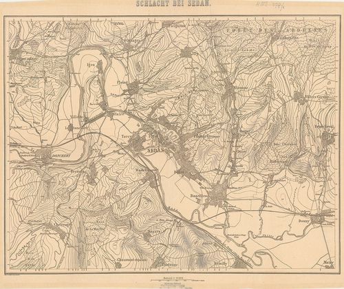
| Title | Schlacht bei Sedan. |
| Main title | Sedan (Fr.) és környékének térképe. |
141. Stellung der Franzosen am Morgen des 1-sten September [bei S... [H IV c 275]
Institute and Museum of Military History •
H IV c (1841–1913)
•
H IV Újabbkori háborúk
•
H Háborúk
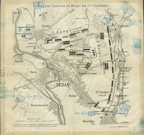
| Title | Stellung der Franzosen am Morgen des 1-sten September [bei Sedan]. |
| Main title | A sedani (Fr.) csata helyszínrajza, 1870. Sedan és erődítései alaprajzban. (Német–francia háború 1870–71.) Francia hadállások, hadmozdulatok. Felvonulási utak. Csapatjelzések, parancsnokok nevei a térképen. Színes ceruzával külön bejegyzések. (Skizze 5 ismeretlen műből.) |
142. Schlacht bei Spicheren 1870–71. [H IV c 276]
Institute and Museum of Military History •
H IV c (1841–1913)
•
H IV Újabbkori háborúk
•
H Háborúk
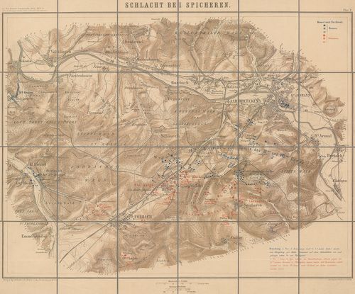
| Title | Schlacht bei Spicheren 1870–71. |
| Main title | Spicheren és környékének csatatérképe. |
143. Plan zum Treffen bei Villepion am 1. Dezember 1870. [H IV c 278/1]
Institute and Museum of Military History •
H IV c (1841–1913)
•
H IV Újabbkori háborúk
•
H Háborúk
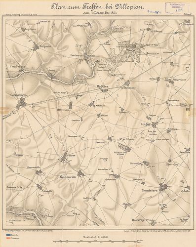
| Title | Plan zum Treffen bei Villepion am 1. Dezember 1870. |
| Main title | A villepioni (Fr.) csata helyszínrajza, 1870. (Német–francia háború 1870–71.) 3 db oleátával a hadmozdulatokról. |
144. A nouarti ütközet [helyszínrajza] 1870. augusztus 29-én. [H IV c 278/2]
Institute and Museum of Military History •
H IV c (1841–1913)
•
H IV Újabbkori háborúk
•
H Háborúk
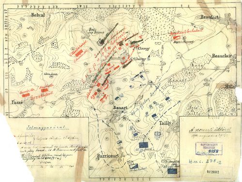
| Title | A nouarti ütközet [helyszínrajza] 1870. augusztus 29-én. |
| Main title | Nouart (Fr.) környéke. (Német–francia háború 1870–71.) Hadállások, hadmozdulatok. Útvonalak. |
145. Schlacht bei Beaumont 30. August 1870. Gefecht bei Remilly s... [H IV c 279]
Institute and Museum of Military History •
H IV c (1841–1913)
•
H IV Újabbkori háborúk
•
H Háborúk
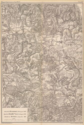
| Title | Schlacht bei Beaumont 30. August 1870. Gefecht bei Remilly sur Meuse 31. August 1870. Schlacht bei Sedan 1. September 1870. |
| Main title | A porosz–francia háború 1870–71. Baumont Remilly, Sedan (Fr.) és környékének térképe az 1870. évi csaták idejéből. |
146. Situationsplan der Belagerungsarbeiten vor Belfort 1870. und... [H IV c 286]
Institute and Museum of Military History •
H IV c (1841–1913)
•
H IV Újabbkori háborúk
•
H Háborúk
| Title | Situationsplan der Belagerungsarbeiten vor Belfort 1870. und 71. |
| Main title | Belfort (Fr.) és környéke vázlatos térképe. A város és erődítései alaprajzban. Védőművek. Az ostromló német haderők sánc- és futóárok-rendszere. Kilövőhelyek és lővonalak. |
147. Plan der Belagerungsarbeiten bei Strassburg 1870. [H IV c 294]
Institute and Museum of Military History •
H IV c (1841–1913)
•
H IV Újabbkori háborúk
•
H Háborúk
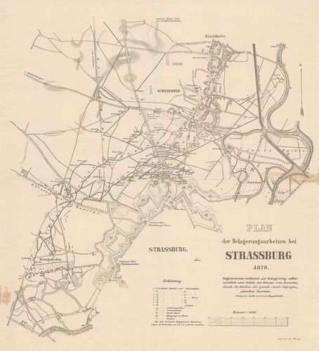
| Title | Plan der Belagerungsarbeiten bei Strassburg 1870. |
| Main title | Strassburg (Fr.) ostrom-művei, 1870. (Német–francia háború 1870–71.) Erődök, kiserődök, sáncok, futóárkok, útvonalak. |
148. Plan zur Belagerung von Strassburg [1870.] [H IV c 294/1]
Institute and Museum of Military History •
H IV c (1841–1913)
•
H IV Újabbkori háborúk
•
H Háborúk
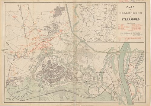
| Title | Plan zur Belagerung von Strassburg [1870.] |
| Main title | Mt.: [Srassburg és tágabb környékének térképe.]Strasbourg: ütegállások a város előterében 1870-ben. Város és vár alaprajzban a német–francia háborúban. |
149. [Gefechtsfeld von -Saarbrücken-Spichern] [H IV c 295]
Institute and Museum of Military History •
H IV c (1841–1913)
•
H IV Újabbkori háborúk
•
H Háborúk
| Title | [Gefechtsfeld von -Saarbrücken-Spichern] |
| Main title | A Saarbrücken (No.) – Spichern (Fr.) közötti hadszíntér. (Német–francia háború 1870–71.) |
150. [Gefechtsfeld von Mars la Tour, Vionville] [H IV c 296]
Institute and Museum of Military History •
H IV c (1841–1913)
•
H IV Újabbkori háborúk
•
H Háborúk
| Title | [Gefechtsfeld von Mars la Tour, Vionville] |
| Main title | A Mars la Tour – Vionville (Fr.) közötti hadszíntér. (Német–francia háború 1870–71.) |