81. Übersichtskarte der telegraphischen Längenbestimmungen. Cart... [B I c 121]
Institute and Museum of Military History •
B I c
•
B I Európa
•
B I–XV. Európa
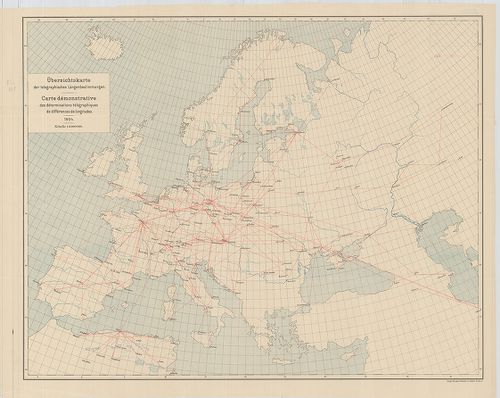
| Title | Übersichtskarte der telegraphischen Längenbestimmungen. Carte démonstrative des déterminations télégraphiques dex différences de longitudes. 1904. |
| Main title | Európa távíró vonalai 1904-ben. |
82. Übersichtskarte der Bestimmungen der Schwerkraft. Carte demo... [B I c 122]
Institute and Museum of Military History •
B I c
•
B I Európa
•
B I–XV. Európa
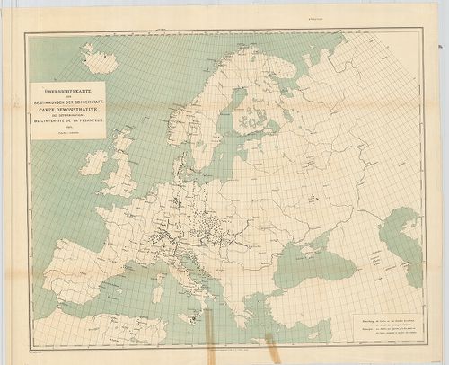
| Title | Übersichtskarte der Bestimmungen der Schwerkraft. Carte demonstrative des déterminations de lintensité de la pesanteur. |
| Main title | Európa térképe a meghatározott nehézségi erővel 1900-ban. |
83. Übersichtskarte für den Stand der Trigonometrischen Arbeiten... [B I c 123]
Institute and Museum of Military History •
B I c
•
B I Európa
•
B I–XV. Európa
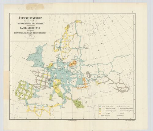
| Title | Übersichtskarte für den Stand der Trigonometrischen Arbeiten. Carte synoptique indiquant l’état actuel des travaux trigonométriques. |
| Main title | Európa térképe a háromszögelési munkák állásáról 1904-ben. |
84. Europe. Europa Mobil. [B I c 125]
Institute and Museum of Military History •
B I c
•
B I Európa
•
B I–XV. Európa
| Title | Europe. Europa Mobil. |
| Main title | Európa autóúttérképe. |
85. Grandes routes de trafic international. Routes de trafic nat... [B I c 126]
Institute and Museum of Military History •
B I c
•
B I Európa
•
B I–XV. Európa
| Title | Grandes routes de trafic international. Routes de trafic national. [Európa.] |
| Main title | Európa autóúttérképe. |
86. Klimaticseszkaja karta Evropü. Ucsebnaja karta. [B I c 127]
Institute and Museum of Military History •
B I c
•
B I Európa
•
B I–XV. Európa
| Title | Klimaticseszkaja karta Evropü. Ucsebnaja karta. |
| Main title | Európa éghajlati térképe. |
87. Prirodnüe zonü Evropü. Ucsebnaja karta. [B I c 128]
Institute and Museum of Military History •
B I c
•
B I Európa
•
B I–XV. Európa
| Title | Prirodnüe zonü Evropü. Ucsebnaja karta. |
| Main title | Európa természeti zónái. |
88. [Európa állatföldrajzi térképe.] [B I c 133]
Institute and Museum of Military History •
B I c
•
B I Európa
•
B I–XV. Európa
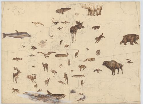
| Title | [Európa állatföldrajzi térképe.] |
89. Europa. Strassenatlas. [B I c 134]
Institute and Museum of Military History •
B I c
•
B I Európa
•
B I–XV. Európa
| Title | Europa. Strassenatlas. |
| Main title | Európa autóatlasza 1969-ben. |
90. Europa, mapa samochodowa. [B I c 135]
Institute and Museum of Military History •
B I c
•
B I Európa
•
B I–XV. Európa
| Title | Europa, mapa samochodowa. |
| Main title | 26 mt.: városáthajtási térképek. |
| Subject | Európa autóúttérképe 1965-ben. |
91. Evropa glavni avtomobilni putisa. [B I c 136]
Institute and Museum of Military History •
B I c
•
B I Európa
•
B I–XV. Európa
| Title | Evropa glavni avtomobilni putisa. |
| Main title | Európa autóúttérképe 1967-ben. |
92. Europa. Hospodařská mapa. [B I c 137]
Institute and Museum of Military History •
B I c
•
B I Európa
•
B I–XV. Európa
| Title | Europa. Hospodařská mapa. |
| Main title | 5 mt.: 1. Donecká panev. (A Dón-medence) 2. Ludnatost (Népsűrűség.) 3. Porúři, (Düsseldorf és környéke.) 4. Štředni Anglie. (Közép-Anglia) 5. Ostravsko-Karvinska a Hornoslezská panev. (Ostrava-Karviná és Hornoslezská-medence.) |
| Subject | Európa gazdaségi térképe 1961-ben. |
93. Europa carta stradale igda-turist. [B I c 138]
Institute and Museum of Military History •
B I c
•
B I Európa
•
B I–XV. Európa
| Title | Europa carta stradale igda-turist. |
| Main title | Európa autóúttérképe. |
94. Carta automobilistica d’Europa – Touring Club Haliano. [B I c 139]
Institute and Museum of Military History •
B I c
•
B I Európa
•
B I–XV. Európa
| Title | Carta automobilistica d’Europa – Touring Club Haliano. |
| Main title | Európa autóúttérképe 1965-ből. |
95. Imperium Romanum. [B I c 140]
Institute and Museum of Military History •
B I c
•
B I Európa
•
B I–XV. Európa
| Title | Imperium Romanum. |
| Main title | 1 mt.: Naše Krajiny |
| Subject | Csehország tartományi része a Római Birodalom idején. |
96. Übersichtskarte der Eisenbahnen in Europa. [B I c 141]
Institute and Museum of Military History •
B I c
•
B I Európa
•
B I–XV. Európa
| Title | Übersichtskarte der Eisenbahnen in Europa. |
| Main title | Mt.: Európa-Asien. |
| Subject | Európa vasúthálózati áttekintő térképe. |
97. Politisch-Geographische Grundlagen Europas-Flemming Friedens... [B I c 142]
Institute and Museum of Military History •
B I c
•
B I Európa
•
B I–XV. Európa
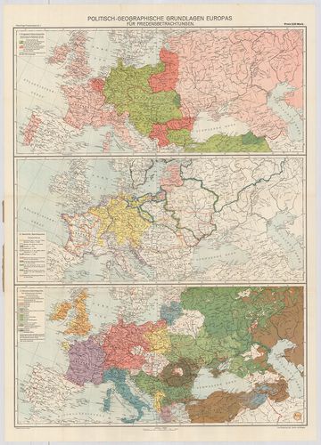
| Title | Politisch-Geographische Grundlagen Europas-Flemming Friedenskarten |
| Main title | 3 térk. 1. Európa háborús térkép 2. Európa történelmi térkép 3. Európa népességi térkép. |
| Subject | Európa politikai-földrajzi térképe 1917-ben. |
98. Európai háború kis térképe. [B I c 143]
Institute and Museum of Military History •
B I c
•
B I Európa
•
B I–XV. Európa
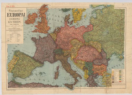
| Title | Európai háború kis térképe. |
99. Flemmings Übersichtskarte für den europäischen Kriegsschaupa... [B I c 144]
Institute and Museum of Military History •
B I c
•
B I Európa
•
B I–XV. Európa
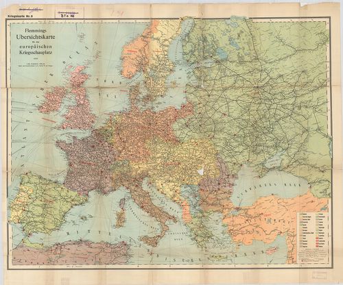
| Title | Flemmings Übersichtskarte für den europäischen Kriegsschaupaltz. |
| Main title | Az európai hadszíntér áttekintő térképe az első világháborúban. |
100. Ravensteins Karte des Deutschen Sperrgebietes für den uneing... [B I c 145]
Institute and Museum of Military History •
B I c
•
B I Európa
•
B I–XV. Európa
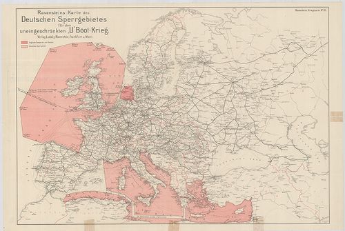
| Title | Ravensteins Karte des Deutschen Sperrgebietes für den uneingeschkränkten „U” Boot-Krieg. Ravensteins Kriegskarte. |
| Main title | Európa térképe. Tengeralattjáró háború a németek által korlátlanul lezárt Európa NY-i és D-i területein. |