51. Evropa sz 1870 po 1914g. [B I c 43]
Institute and Museum of Military History •
B I c
•
B I Európa
•
B I–XV. Európa
| Title | Evropa sz 1870 po 1914g. |
| Main title | 5 mt.: 1. Franko-Pruszszkaja vojna i Parizsszkaja kommuna. (Francia–Porosz háború és a Párizsi kommün.) 2. Parizs v 1871g. (Bor’ba kommunarov sz Verszal’cami). (Parizs és Versailles Fr. népi felkelése.) 3. Balkanü vo vremja Ruszszko-Tureckoj vojnü 1877–1878gg. (Az orosz–török Balkánháború 1877 és 1878-ban.) 4. Pervaja Balkanszkaja vojna (9. X. 1912g.–30. V. 1913g.) (Az első Balkán háború 1912. okt. 9.–1913. máj. 30-ig.) 5. Vtoraja Balkanszkaja vojna (30. VI.–29. VII. 1913g.) (A második Balkán-háború 1913. jún. 30.–júl. 29.-ig.) |
| Subject | Európa 1870 és 1914 között. |
52. Evropa sz 1870 po 1914 g. [B I c 43/1]
Institute and Museum of Military History •
B I c
•
B I Európa
•
B I–XV. Európa
| Title | Evropa sz 1870 po 1914 g. |
| Main title | 3 mt.: 1. Parizsszkaja kommuna. (18. III.–28. V. 1871g.) (A párizsi kommün.) 2. Balkanü vo vremja Ruszszko-Tureckoj vojnü 1877–1878gg. (Az orosz–török balkáni háború 1877–1878-ig.) 3. Balkanszkie vojnü 1912–1913gg. (Az 1912–1913-as Balkán-háború.) |
| Subject | Európa 1870 és 1914 között. |
53. Evropa sz 1815 po 1870 g. – 3 térk.: 1. Evropa v 1815–1859 g... [B I c 44]
Institute and Museum of Military History •
B I c
•
B I Európa
•
B I–XV. Európa
| Title | Evropa sz 1815 po 1870 g. – 3 térk.: 1. Evropa v 1815–1859 gg. |
| Main title | 2. Ob’edinenie Germanii i Ob’edinenie Italii (1859–1871 gg.) |
| Subject | 3. 1 Internacional v Evrope. |
54. International personenverkehrskarte. [B I c 59]
Institute and Museum of Military History •
B I c
•
B I Európa
•
B I–XV. Európa
| Title | International personenverkehrskarte. |
| Main title | Európa vasúttérképe 1966-ban. |
55. Carte itinéraire des voies navigables de l’Europe. [B I c 60]
Institute and Museum of Military History •
B I c
•
B I Európa
•
B I–XV. Európa
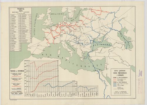
| Title | Carte itinéraire des voies navigables de l’Europe. |
| Main title | Európa légi útjainak térképe 1928. |
56. Európa vasúti térképe. [B I c 61]
Institute and Museum of Military History •
B I c
•
B I Európa
•
B I–XV. Európa
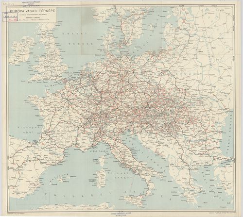
| Title | Európa vasúti térképe. |
57. Hauptverkehrslinien von Europa. [B I c 62]
Institute and Museum of Military History •
B I c
•
B I Európa
•
B I–XV. Európa
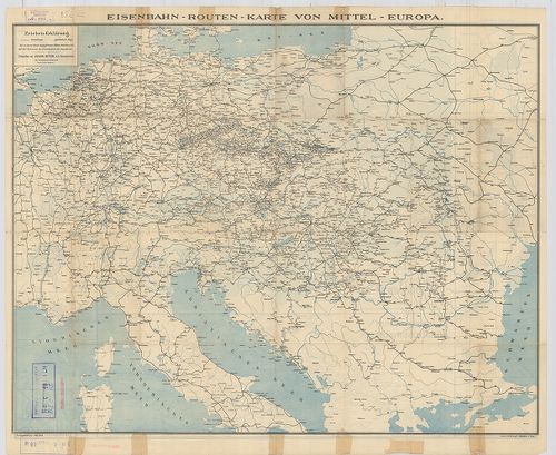
| Title | Hauptverkehrslinien von Europa. |
| Main title | 2 mt. 1. Eisenbahnlinien im nördlichen Böhmen. (Észak-Csehország vasútvonalai.) 2. Eisenbahnkarte von Sibirien. (Szibériai vasút, SzU.) 19 Lage der Bahnhöfe. (19 vasútforg. várostérképe.) Hátlapon: Eisenbahn-Routen-Karte von Mitteleuropa. (Közép-Európa vasút és úttérképe.) |
| Subject | Európa közlekedési térképe 1904-ben. |
58. Maps of Europe and Germany. Including railroad, steamship, a... [B I c 64]
Institute and Museum of Military History •
B I c
•
B I Európa
•
B I–XV. Európa
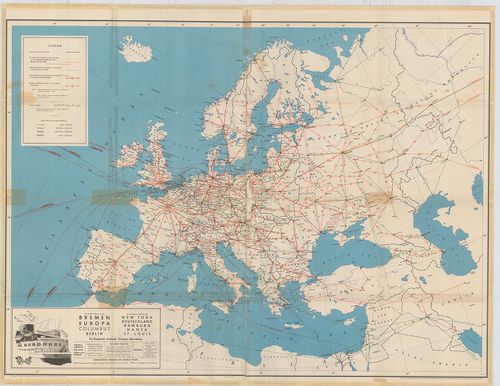
| Title | Maps of Europe and Germany. Including railroad, steamship, auto and air routes. |
| Main title | hátl.: Map of Germany. |
| Subject | Európa közlekedési térképe 1936-ban. |
59. Die Schnellzugslinien Europas. European Express Train Servic... [B I c 65]
Institute and Museum of Military History •
B I c
•
B I Európa
•
B I–XV. Európa
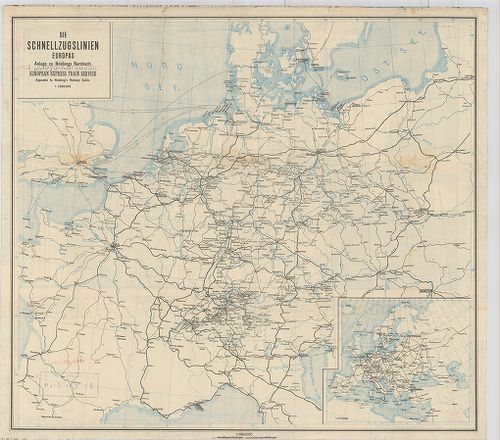
| Title | Die Schnellzugslinien Europas. European Express Train Service. |
| Main title | Mt.: Europa. Anlage zu Hobbings Kursbuch. |
| Subject | Nyugat- és Közép-Európa gyorsvonati vonalai a XX. század elején. |
60. Nivellements de précision. Lignes existant en Europa (Russie... [B I c 66]
Institute and Museum of Military History •
B I c
•
B I Európa
•
B I–XV. Európa
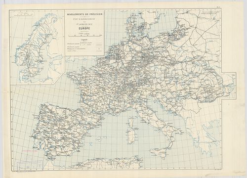
| Title | Nivellements de précision. Lignes existant en Europa (Russie exceptée) et en Afrique… |
| Main title | Európa úthálózati térképe 1903-ban. |
61. Európa rádió adóállomásai [B I c 67]
Institute and Museum of Military History •
B I c
•
B I Európa
•
B I–XV. Európa
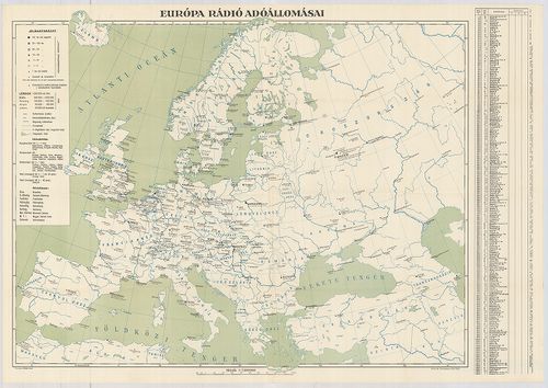
| Title | Európa rádió adóállomásai |
62. L’Europe en Automobile. Europe motoring. Through Europe. [B I c 68]
Institute and Museum of Military History •
B I c
•
B I Európa
•
B I–XV. Európa
| Title | L’Europe en Automobile. Europe motoring. Through Europe. |
| Main title | Európa autóúthálózatának térképe |
63. L’Europe en Automobile. – Europe motoring. – Through Europe. [B I c 69]
Institute and Museum of Military History •
B I c
•
B I Európa
•
B I–XV. Európa
| Title | L’Europe en Automobile. – Europe motoring. – Through Europe. |
| Main title | Európa autóúthálózatának térképe. |
64. Neueste Reise-Hand-Und Kontorkarte von Europa mit den angren... [B I c 70]
Institute and Museum of Military History •
B I c
•
B I Európa
•
B I–XV. Európa
| Title | Neueste Reise-Hand-Und Kontorkarte von Europa mit den angrenzenden Teilen von Asien und Afrika. |
| Main title | Európa és Ázsia, Afrika határos részeinek úthálózati térképe. |
65. Europa Gesamtkarte. [B I c 71]
Institute and Museum of Military History •
B I c
•
B I Európa
•
B I–XV. Európa
| Title | Europa Gesamtkarte. |
| Main title | Európa közlekedési térképe. |
66. Karte von Europa und Westasien. [B I c 78]
Institute and Museum of Military History •
B I c
•
B I Európa
•
B I–XV. Európa
| Title | Karte von Europa und Westasien. |
| Main title | Európa térképe 1940-ben. |
67. Magyar Királyi Lég-ügyi Hivatal Időjelző Központ. [B I c 79]
Institute and Museum of Military History •
B I c
•
B I Európa
•
B I–XV. Európa
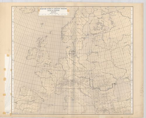
| Title | Magyar Királyi Lég-ügyi Hivatal Időjelző Központ. |
68. Schaubild von Europa mit bildlicher Darstellung der hauptsäc... [B I c 80]
Institute and Museum of Military History •
B I c
•
B I Európa
•
B I–XV. Európa
| Title | Schaubild von Europa mit bildlicher Darstellung der hauptsächlichsten Wirtschaftsgüter, Bodenschätze, Industriezentren. |
| Main title | Európa térképe gazdasági adatokkal 1940 körül. |
69. Angling in troubled Waters. – Der Fischfang im Trüben – La P... [B I c 85]
Institute and Museum of Military History •
B I c
•
B I Európa
•
B I–XV. Európa
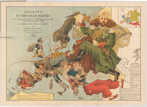
| Title | Angling in troubled Waters. – Der Fischfang im Trüben – La Peche en eau trouble – La Pesca nelle acque turbes. A Serio-Comic Map of Europe. |
| Main title | Mt.: Key Map of Europe. (Európa térképe.) |
| Subject | „Halászat a zavarosban" - tréfás rajz Európáról. 1899. |
70. G. Freytags Völkerkarte von Europa. [B I c 88]
Institute and Museum of Military History •
B I c
•
B I Európa
•
B I–XV. Európa
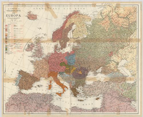
| Title | G. Freytags Völkerkarte von Europa. |
| Main title | Európa néprajzi térképe. |
71. Länder- und Völkerkarte Europas. [B I c 89]
Institute and Museum of Military History •
B I c
•
B I Európa
•
B I–XV. Európa
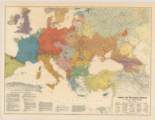
| Title | Länder- und Völkerkarte Europas. |
| Main title | Európa ország és néprajzi térképe. |
72. Nova karta Evrope. Po ryszkom lisztu „Novoe Zveno”. [B I c 90]
Institute and Museum of Military History •
B I c
•
B I Európa
•
B I–XV. Európa
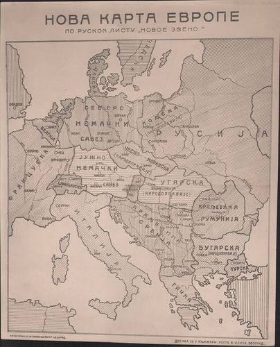
| Title | Nova karta Evrope. Po ryszkom lisztu „Novoe Zveno”. |
| Main title | Európa tervezett határrendezése az első világháború után. |
73. Europa etnografica. [B I c 94]
Institute and Museum of Military History •
B I c
•
B I Európa
•
B I–XV. Európa

| Title | Europa etnografica. |
| Main title | Európa néprajzi térképe 1940-ben. |
74. Groessen und Bevoelkerungs karte von Europa. [B I c 95]
Institute and Museum of Military History •
B I c
•
B I Európa
•
B I–XV. Európa
| Title | Groessen und Bevoelkerungs karte von Europa. |
| Main title | Európa népessége táblázatban, Németország részletezve. (Térkép nincs) |
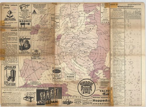
75. Európa rádiótérképe. [B I c 100]
Institute and Museum of Military History •
B I c
•
B I Európa
•
B I–XV. Európa
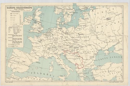
| Title | Európa rádiótérképe. |
76. Mapa radjokomunikacyjna Europy. [B I c 101]
Institute and Museum of Military History •
B I c
•
B I Európa
•
B I–XV. Európa
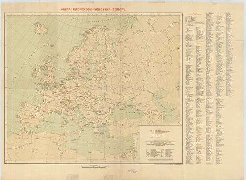
| Title | Mapa radjokomunikacyjna Europy. |
| Main title | Európa rádióállomásainak térképe 1936. |
77. [Európa rádióállomásai.] [B I c 102/a]
Institute and Museum of Military History •
B I c
•
B I Európa
•
B I–XV. Európa
| Title | [Európa rádióállomásai.] |
78. [A világ rádióállomásai] [B I c 102/b]
Institute and Museum of Military History •
B I c
•
B I Európa
•
B I–XV. Európa

| Title | [A világ rádióállomásai] |
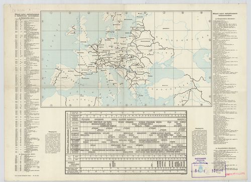
79. Európa rádióadó-állomásainak hullámhossz, kilowatt- és távol... [B I c 103]
Institute and Museum of Military History •
B I c
•
B I Európa
•
B I–XV. Európa
| Title | Európa rádióadó-állomásainak hullámhossz, kilowatt- és távolsági térképe. |
80. Übersichtskarte der Breiten- und Azimutbestimmungen. Carte d... [B I c 120]
Institute and Museum of Military History •
B I c
•
B I Európa
•
B I–XV. Európa
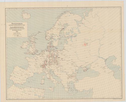
| Title | Übersichtskarte der Breiten- und Azimutbestimmungen. Carte demonstrative des déterminations astronomiques de latitude et d’azimut. 1904. |
| Main title | Európa térképe a földr. szélesség és azimut meghatározásokkal 1904-ben. |
81. Übersichtskarte der telegraphischen Längenbestimmungen. Cart... [B I c 121]
Institute and Museum of Military History •
B I c
•
B I Európa
•
B I–XV. Európa
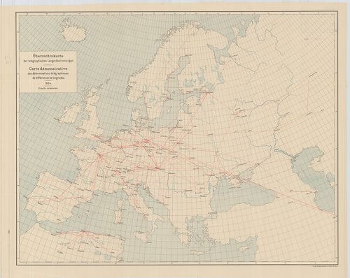
| Title | Übersichtskarte der telegraphischen Längenbestimmungen. Carte démonstrative des déterminations télégraphiques dex différences de longitudes. 1904. |
| Main title | Európa távíró vonalai 1904-ben. |
82. Übersichtskarte der Bestimmungen der Schwerkraft. Carte demo... [B I c 122]
Institute and Museum of Military History •
B I c
•
B I Európa
•
B I–XV. Európa
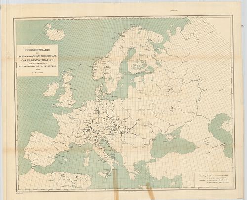
| Title | Übersichtskarte der Bestimmungen der Schwerkraft. Carte demonstrative des déterminations de lintensité de la pesanteur. |
| Main title | Európa térképe a meghatározott nehézségi erővel 1900-ban. |
83. Übersichtskarte für den Stand der Trigonometrischen Arbeiten... [B I c 123]
Institute and Museum of Military History •
B I c
•
B I Európa
•
B I–XV. Európa
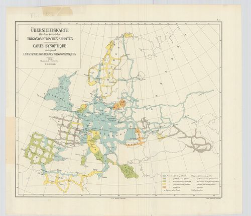
| Title | Übersichtskarte für den Stand der Trigonometrischen Arbeiten. Carte synoptique indiquant l’état actuel des travaux trigonométriques. |
| Main title | Európa térképe a háromszögelési munkák állásáról 1904-ben. |
84. Europe. Europa Mobil. [B I c 125]
Institute and Museum of Military History •
B I c
•
B I Európa
•
B I–XV. Európa
| Title | Europe. Europa Mobil. |
| Main title | Európa autóúttérképe. |
85. Grandes routes de trafic international. Routes de trafic nat... [B I c 126]
Institute and Museum of Military History •
B I c
•
B I Európa
•
B I–XV. Európa
| Title | Grandes routes de trafic international. Routes de trafic national. [Európa.] |
| Main title | Európa autóúttérképe. |
86. Klimaticseszkaja karta Evropü. Ucsebnaja karta. [B I c 127]
Institute and Museum of Military History •
B I c
•
B I Európa
•
B I–XV. Európa
| Title | Klimaticseszkaja karta Evropü. Ucsebnaja karta. |
| Main title | Európa éghajlati térképe. |
87. Prirodnüe zonü Evropü. Ucsebnaja karta. [B I c 128]
Institute and Museum of Military History •
B I c
•
B I Európa
•
B I–XV. Európa
| Title | Prirodnüe zonü Evropü. Ucsebnaja karta. |
| Main title | Európa természeti zónái. |
88. [Európa állatföldrajzi térképe.] [B I c 133]
Institute and Museum of Military History •
B I c
•
B I Európa
•
B I–XV. Európa
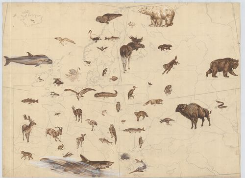
| Title | [Európa állatföldrajzi térképe.] |
89. Europa. Strassenatlas. [B I c 134]
Institute and Museum of Military History •
B I c
•
B I Európa
•
B I–XV. Európa
| Title | Europa. Strassenatlas. |
| Main title | Európa autóatlasza 1969-ben. |
90. Europa, mapa samochodowa. [B I c 135]
Institute and Museum of Military History •
B I c
•
B I Európa
•
B I–XV. Európa
| Title | Europa, mapa samochodowa. |
| Main title | 26 mt.: városáthajtási térképek. |
| Subject | Európa autóúttérképe 1965-ben. |
91. Evropa glavni avtomobilni putisa. [B I c 136]
Institute and Museum of Military History •
B I c
•
B I Európa
•
B I–XV. Európa
| Title | Evropa glavni avtomobilni putisa. |
| Main title | Európa autóúttérképe 1967-ben. |
92. Europa. Hospodařská mapa. [B I c 137]
Institute and Museum of Military History •
B I c
•
B I Európa
•
B I–XV. Európa
| Title | Europa. Hospodařská mapa. |
| Main title | 5 mt.: 1. Donecká panev. (A Dón-medence) 2. Ludnatost (Népsűrűség.) 3. Porúři, (Düsseldorf és környéke.) 4. Štředni Anglie. (Közép-Anglia) 5. Ostravsko-Karvinska a Hornoslezská panev. (Ostrava-Karviná és Hornoslezská-medence.) |
| Subject | Európa gazdaségi térképe 1961-ben. |
93. Europa carta stradale igda-turist. [B I c 138]
Institute and Museum of Military History •
B I c
•
B I Európa
•
B I–XV. Európa
| Title | Europa carta stradale igda-turist. |
| Main title | Európa autóúttérképe. |
94. Carta automobilistica d’Europa – Touring Club Haliano. [B I c 139]
Institute and Museum of Military History •
B I c
•
B I Európa
•
B I–XV. Európa
| Title | Carta automobilistica d’Europa – Touring Club Haliano. |
| Main title | Európa autóúttérképe 1965-ből. |
95. Imperium Romanum. [B I c 140]
Institute and Museum of Military History •
B I c
•
B I Európa
•
B I–XV. Európa
| Title | Imperium Romanum. |
| Main title | 1 mt.: Naše Krajiny |
| Subject | Csehország tartományi része a Római Birodalom idején. |
96. Übersichtskarte der Eisenbahnen in Europa. [B I c 141]
Institute and Museum of Military History •
B I c
•
B I Európa
•
B I–XV. Európa
| Title | Übersichtskarte der Eisenbahnen in Europa. |
| Main title | Mt.: Európa-Asien. |
| Subject | Európa vasúthálózati áttekintő térképe. |
97. Politisch-Geographische Grundlagen Europas-Flemming Friedens... [B I c 142]
Institute and Museum of Military History •
B I c
•
B I Európa
•
B I–XV. Európa
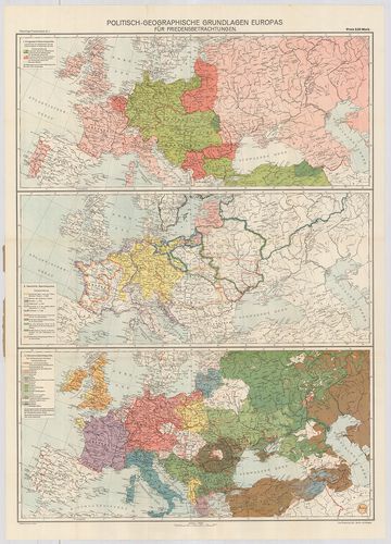
| Title | Politisch-Geographische Grundlagen Europas-Flemming Friedenskarten |
| Main title | 3 térk. 1. Európa háborús térkép 2. Európa történelmi térkép 3. Európa népességi térkép. |
| Subject | Európa politikai-földrajzi térképe 1917-ben. |
98. Európai háború kis térképe. [B I c 143]
Institute and Museum of Military History •
B I c
•
B I Európa
•
B I–XV. Európa
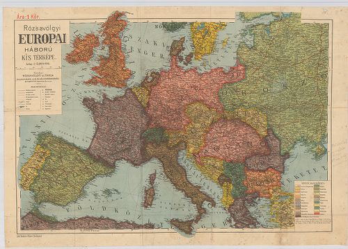
| Title | Európai háború kis térképe. |
99. Flemmings Übersichtskarte für den europäischen Kriegsschaupa... [B I c 144]
Institute and Museum of Military History •
B I c
•
B I Európa
•
B I–XV. Európa
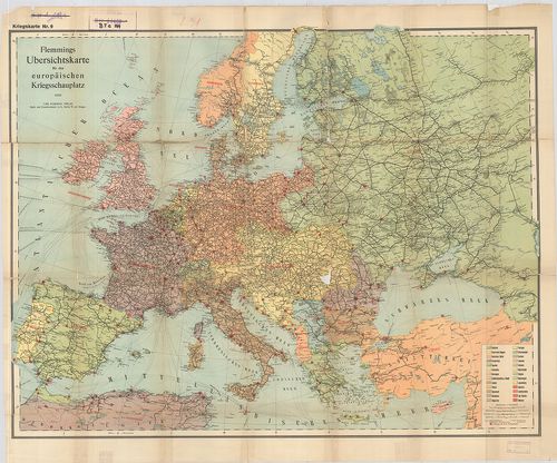
| Title | Flemmings Übersichtskarte für den europäischen Kriegsschaupaltz. |
| Main title | Az európai hadszíntér áttekintő térképe az első világháborúban. |
100. Ravensteins Karte des Deutschen Sperrgebietes für den uneing... [B I c 145]
Institute and Museum of Military History •
B I c
•
B I Európa
•
B I–XV. Európa
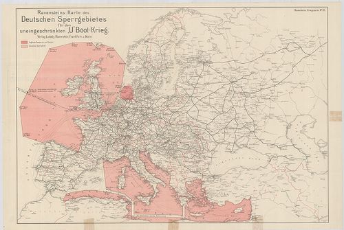
| Title | Ravensteins Karte des Deutschen Sperrgebietes für den uneingeschkränkten „U” Boot-Krieg. Ravensteins Kriegskarte. |
| Main title | Európa térképe. Tengeralattjáró háború a németek által korlátlanul lezárt Európa NY-i és D-i területein. |