321. Europa Atlante Automobilistico [B II c 117]
Institute and Museum of Military History •
B II c
•
B II Európa, nagyobb részek és országcsoportok
•
B I–XV. Európa
| Title | Europa Atlante Automobilistico |
| Main title | Európa autóatlasza. |
322. Kelet-Európa autótérképe. [B II c 118]
Institute and Museum of Military History •
B II c
•
B II Európa, nagyobb részek és országcsoportok
•
B I–XV. Európa
| Title | Kelet-Európa autótérképe. |
| Main title | Mt.: [Szovjetunió NY-i része.] |
323. Road Map of eastern Europa. – Europe de l’Est Carte Routiére... [B II c 118/1]
Institute and Museum of Military History •
B II c
•
B II Európa, nagyobb részek és országcsoportok
•
B I–XV. Európa
| Title | Road Map of eastern Europa. – Europe de l’Est Carte Routiére – Autokarte von Osteuropa. |
| Main title | Mt.: [Kelet-Európa.] |
| Subject | Kelet-Európa autótérképe 1967-ben. |
324. Nyugat-Európa autótérképe. [B II c 119]
Institute and Museum of Military History •
B II c
•
B II Európa, nagyobb részek és országcsoportok
•
B I–XV. Európa
| Title | Nyugat-Európa autótérképe. |
| Main title | 2 mt.: [Dánia–Skandinávia D-i része.] |
| Subject | 2. [Olaszország D-i része és Szicília szg.] |
325. Kriegstheater oder Graenzkarte Oesterreichs, Russlands und d... [B II c 120]
Institute and Museum of Military History •
B II c
•
B II Európa, nagyobb részek és országcsoportok
•
B I–XV. Európa
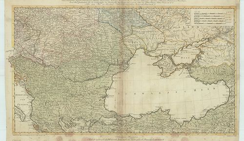
| Title | Kriegstheater oder Graenzkarte Oesterreichs, Russlands und der Türkey... |
| Main title | Az Osztrák Birodalom, Oroszország és Törökország határvidékének térképe (a Fekete-tenger országai) 1788-ban. |
326. Projectirte Bahnen durch Siebenbürgen in Verbindung mit den ... [B II c 121]
Institute and Museum of Military History •
B II c
•
B II Európa, nagyobb részek és országcsoportok
•
B I–XV. Európa
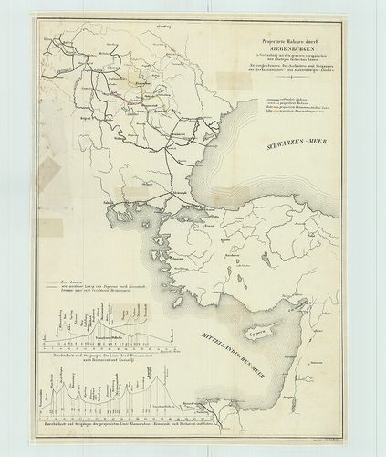
| Title | Projectirte Bahnen durch Siebenbürgen in Verbindung mit den grossen europäischen und künftigen türkischen Linien. |
| Main title | Vasútvonal tervezet Erdély és az európai Törökország összeköttetéséről. |
327. Pregledna Karte Evropskih železnica sa prelaznim stanicama ž... [B II c 122]
Institute and Museum of Military History •
B II c
•
B II Európa, nagyobb részek és országcsoportok
•
B I–XV. Európa
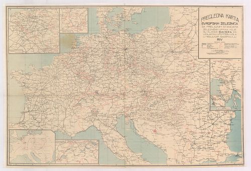
| Title | Pregledna Karte Evropskih železnica sa prelaznim stanicama železničkih uprava koje su članice saveza za uzajamnu upotpebu kola u medjunar. saobraćaju RIV. |
| Main title | 6 mt.: 1. Belgija i Luxemburg (Belgium és Luxemburg.) 2. Područje Saara. (Saarvidék) 3. Švajcarska (Svájc.) 4. Istra Slovenačko Primorje (Isztria félsziget) 5. Trst (Trieste) 6. [Közép-Európa.] |
| Subject | Közép-Európa vasúttérképe 1949-ben. |
328. Fina Europa Atlas. [B II c 123]
Institute and Museum of Military History •
B II c
•
B II Európa, nagyobb részek és országcsoportok
•
B I–XV. Európa
| Title | Fina Europa Atlas. |
| Main title | Európa közlekedési atlasza az 1950-es években. |
329. Strassenkarte Nordwesteuropa. [B II c 124]
Institute and Museum of Military History •
B II c
•
B II Európa, nagyobb részek és országcsoportok
•
B I–XV. Európa
| Title | Strassenkarte Nordwesteuropa. |
| Main title | Road map Northwestern Europe. – Carte routiére Europe du Nord-Ouest... |
| Subject | Északnyugat-Európa úttérképe 1956-ban. |
330. Western Europe and adjacent North Africa. [B II c 125]
Institute and Museum of Military History •
B II c
•
B II Európa, nagyobb részek és országcsoportok
•
B I–XV. Európa
| Title | Western Europe and adjacent North Africa. |
| Main title | Road map and Pictorial Guide. Follow the „Esso Route” Hátl.: 1. Relief map. 2. Pictorial Guide. |
| Subject | Nyugat-Európa és Észak-Afrika egy részének autótérképe 1956-ban. |
331. Western Europe and adjacent North Africa. [B II c 125/1]
Institute and Museum of Military History •
B II c
•
B II Európa, nagyobb részek és országcsoportok
•
B I–XV. Európa
| Title | Western Europe and adjacent North Africa. |
| Main title | Road map and Pictorial Guide. Follow the „Esso Route” Hátl.: 1. Relief map. 2. Pictorial Guide. |
| Subject | Nyugat-Európa és Észak-Afrika egy részének autótérképe 1959-ben. |
332. Central Europe. Bartholomew’s World Series. Road map. Carte ... [B II c 127]
Institute and Museum of Military History •
B II c
•
B II Európa, nagyobb részek és országcsoportok
•
B I–XV. Európa
| Title | Central Europe. Bartholomew’s World Series. Road map. Carte Routiére ... |
| Main title | Közép-Európa közlekedési térképe 1963-ban. |
333. Continental Atlas, Deutschland, Benelux- und Alpenländer. [B II c 128]
Institute and Museum of Military History •
B II c
•
B II Európa, nagyobb részek és országcsoportok
•
B I–XV. Európa
| Title | Continental Atlas, Deutschland, Benelux- und Alpenländer. |
| Main title | Európa: Németország, Benelux államok és az Alpok országai autóatlasza 1956-ban. |
334. Europa. Cartoguide Européen SHELL Touring [Borítócím] [B II c 129]
Institute and Museum of Military History •
B II c
•
B II Európa, nagyobb részek és országcsoportok
•
B I–XV. Európa
| Title | Europa. Cartoguide Européen SHELL Touring [Borítócím] |
| Main title | Közép-Európa közlekedési térképe 1960-ban. |
335. Europe. Europa Autokarte. – Road map. – Carte Automobile. – ... [B II c 130]
Institute and Museum of Military History •
B II c
•
B II Európa, nagyobb részek és országcsoportok
•
B I–XV. Európa
| Title | Europe. Europa Autokarte. – Road map. – Carte Automobile. – Carte stradale. |
| Main title | Mt.: [Dél-Skandinávia.] |
| Subject | Európa autótérképe az 1950-es években. |
336. Europe Atlas Routier. – Strassenatlas. – Road Atlas. – Atlan... [B II c 131]
Institute and Museum of Military History •
B II c
•
B II Európa, nagyobb részek és országcsoportok
•
B I–XV. Európa
| Title | Europe Atlas Routier. – Strassenatlas. – Road Atlas. – Atlante Stradale. Kötéscím: Europa im Automobil. Reiseführer und Atlas. Internationaler Automobilführer. |
| Main title | Európa autóatlasza. |
337. Strassen – Roads – Veje – Carreteras – Routes – Wegen – Stra... [B II c 132]
Institute and Museum of Military History •
B II c
•
B II Európa, nagyobb részek és országcsoportok
•
B I–XV. Európa
| Title | Strassen – Roads – Veje – Carreteras – Routes – Wegen – Strade – Vägar. Europa |
| Main title | Európa és Németország autóatlasza 1962-ben. |
338. Europe. Europa. Strassenkarte zur Planung von Autoreisen etc... [B II c 133]
Institute and Museum of Military History •
B II c
•
B II Európa, nagyobb részek és országcsoportok
•
B I–XV. Európa
| Title | Europe. Europa. Strassenkarte zur Planung von Autoreisen etc. |
| Main title | 2 mt.: 1. [Európa hegyvízrajzi térk.] 2. [Európa km. táblázata.] |
| Subject | Európa autótérképe 1962-ben. |
339. Europe road map. [B II c 134]
Institute and Museum of Military History •
B II c
•
B II Európa, nagyobb részek és országcsoportok
•
B I–XV. Európa
| Title | Europe road map. |
| Main title | Európa úttérképe. |
340. Freytag–Berndt Strassenkarte Südwesteuropa. Road map Southwe... [B II c 135]
Institute and Museum of Military History •
B II c
•
B II Európa, nagyobb részek és országcsoportok
•
B I–XV. Európa

| Title | Freytag–Berndt Strassenkarte Südwesteuropa. Road map Southwestern Europa. Carte routiére Europe du Sud-Ouest... |
| Main title | Délnyugat-Európa közlekedési térképe 1954-ben. |