121. Europa. Cartoguide Européen SHELL Touring [Borítócím] [B II c 129]
Institute and Museum of Military History •
B II c
•
B II Európa, nagyobb részek és országcsoportok
•
B I–XV. Európa
| Title | Europa. Cartoguide Européen SHELL Touring [Borítócím] |
| Main title | Közép-Európa közlekedési térképe 1960-ban. |
122. Europe. Europa Autokarte. – Road map. – Carte Automobile. – ... [B II c 130]
Institute and Museum of Military History •
B II c
•
B II Európa, nagyobb részek és országcsoportok
•
B I–XV. Európa
| Title | Europe. Europa Autokarte. – Road map. – Carte Automobile. – Carte stradale. |
| Main title | Mt.: [Dél-Skandinávia.] |
| Subject | Európa autótérképe az 1950-es években. |
123. Europe Atlas Routier. – Strassenatlas. – Road Atlas. – Atlan... [B II c 131]
Institute and Museum of Military History •
B II c
•
B II Európa, nagyobb részek és országcsoportok
•
B I–XV. Európa
| Title | Europe Atlas Routier. – Strassenatlas. – Road Atlas. – Atlante Stradale. Kötéscím: Europa im Automobil. Reiseführer und Atlas. Internationaler Automobilführer. |
| Main title | Európa autóatlasza. |
124. Strassen – Roads – Veje – Carreteras – Routes – Wegen – Stra... [B II c 132]
Institute and Museum of Military History •
B II c
•
B II Európa, nagyobb részek és országcsoportok
•
B I–XV. Európa
| Title | Strassen – Roads – Veje – Carreteras – Routes – Wegen – Strade – Vägar. Europa |
| Main title | Európa és Németország autóatlasza 1962-ben. |
125. Europe. Europa. Strassenkarte zur Planung von Autoreisen etc... [B II c 133]
Institute and Museum of Military History •
B II c
•
B II Európa, nagyobb részek és országcsoportok
•
B I–XV. Európa
| Title | Europe. Europa. Strassenkarte zur Planung von Autoreisen etc. |
| Main title | 2 mt.: 1. [Európa hegyvízrajzi térk.] 2. [Európa km. táblázata.] |
| Subject | Európa autótérképe 1962-ben. |
126. Europe road map. [B II c 134]
Institute and Museum of Military History •
B II c
•
B II Európa, nagyobb részek és országcsoportok
•
B I–XV. Európa
| Title | Europe road map. |
| Main title | Európa úttérképe. |
127. Freytag–Berndt Strassenkarte Südwesteuropa. Road map Southwe... [B II c 135]
Institute and Museum of Military History •
B II c
•
B II Európa, nagyobb részek és országcsoportok
•
B I–XV. Európa

| Title | Freytag–Berndt Strassenkarte Südwesteuropa. Road map Southwestern Europa. Carte routiére Europe du Sud-Ouest... |
| Main title | Délnyugat-Európa közlekedési térképe 1954-ben. |
128. Freytag–Berndt Strassenkarte Mitteleuropa mit Italien. Road ... [B II c 136]
Institute and Museum of Military History •
B II c
•
B II Európa, nagyobb részek és országcsoportok
•
B I–XV. Európa
| Title | Freytag–Berndt Strassenkarte Mitteleuropa mit Italien. Road map Central Europa and Italy. – Carte routiére Europe Centrale et Italie... |
| Main title | Közép-Európa és Olaszország úttérképe 1962-ben. |
129. Freytag–Berndt Strassenkarte Osteuropa. – Road map Eastern E... [B II c 137]
Institute and Museum of Military History •
B II c
•
B II Európa, nagyobb részek és országcsoportok
•
B I–XV. Európa
| Title | Freytag–Berndt Strassenkarte Osteuropa. – Road map Eastern Europa. – Dorozsnaja karta Vosztocsnaja Evropa. – Carte routiére Europe Orientale. |
| Main title | Kelet-Európa úttérképe. |
130. Strassen und Reisekarte Mittel- und Westeuropa. – Carte Rout... [B II c 138]
Institute and Museum of Military History •
B II c
•
B II Európa, nagyobb részek és országcsoportok
•
B I–XV. Európa
| Title | Strassen und Reisekarte Mittel- und Westeuropa. – Carte Routiére JRO de l’Europe centrale et occiedentale... |
| Main title | Közép- és Nyugat-Európa úttérképe. |
131. Freytag–Berndt Strassenkarte Mitteleuropa Italien und Balkan... [B II c 139]
Institute and Museum of Military History •
B II c
•
B II Európa, nagyobb részek és országcsoportok
•
B I–XV. Európa
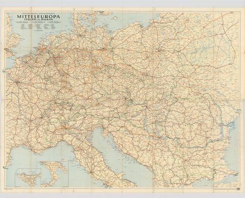
| Title | Freytag–Berndt Strassenkarte Mitteleuropa Italien und Balkan. – Road map Central Europe Italy and The Balkans... |
| Main title | 2 mt.: 1. [Szicília.] |
| Subject | 2. [D. Olaszország.] |
132. Westeuropa mit Spanien und Portugal. Freytag–Berndt Strassen... [B II c 140]
Institute and Museum of Military History •
B II c
•
B II Európa, nagyobb részek és országcsoportok
•
B I–XV. Európa
| Title | Westeuropa mit Spanien und Portugal. Freytag–Berndt Strassenkarte-Road Map Western Europe With Spain and Portugal – Mapa de Carreteras Europa Occidental con Espana y Portugal. – Carte Routiéres Europe Occidentale avec Espagne et Portugal. – Mapa de Estradas Europa Occidental com Espanha e Portugal. |
| Main title | Nyugat-Európa, Spanyolország és Portugália autótérképe 1966-ban. |
133. Alpenstrassen. Tirol – Adria. Autokarte. No 1110 [B II c 141]
Institute and Museum of Military History •
B II c
•
B II Európa, nagyobb részek és országcsoportok
•
B I–XV. Európa
| Title | Alpenstrassen. Tirol – Adria. Autokarte. No 1110 |
| Main title | Az Alpok autóúttérképe 1970-ben. |
134. Riviera – Burgund. Autokarte. [B II c 142]
Institute and Museum of Military History •
B II c
•
B II Európa, nagyobb részek és országcsoportok
•
B I–XV. Európa
| Title | Riviera – Burgund. Autokarte. |
| Main title | 2 mt. 1. Marseille. 2. [Nice és Monte Carlo közötti tengerpart.] |
| Subject | Franciaország déli tengerpartja, a Riviera és Burgundia autótérképe 1970-ben, Svájc és Olaszország egy részével. |
135. Strassen-Karte der Westlichen Alpen. [B II c 143]
Institute and Museum of Military History •
B II c
•
B II Európa, nagyobb részek és országcsoportok
•
B I–XV. Európa
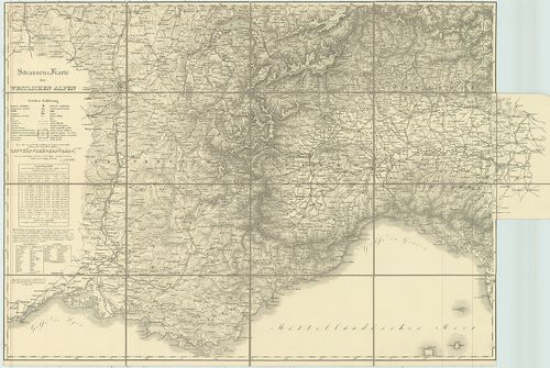
| Title | Strassen-Karte der Westlichen Alpen. |
| Main title | A Nyugati-Alpok úttérképe 1831–32-ben. |
136. Strassen-Karte der Westlichen Alpen. [B II c 144]
Institute and Museum of Military History •
B II c
•
B II Európa, nagyobb részek és országcsoportok
•
B I–XV. Európa
| Title | Strassen-Karte der Westlichen Alpen. |
| Main title | A Nyugati-Alpok úttérképe 1832–1877-ben. |
137. Stassenkarte Osteuropa. ARBÖ.-Freytag–Berndt. [B II c 145]
Institute and Museum of Military History •
B II c
•
B II Európa, nagyobb részek és országcsoportok
•
B I–XV. Európa
| Title | Stassenkarte Osteuropa. ARBÖ.-Freytag–Berndt. |
| Main title | Kelet-Európa úttérképe. |
138. Luftfahrkarte Aeronautical Chart ICAO. [B II c 146]
Institute and Museum of Military History •
B II c
•
B II Európa, nagyobb részek és országcsoportok
•
B I–XV. Európa
| Title | Luftfahrkarte Aeronautical Chart ICAO. |
| Main title | Léginavigációs térképsorozat. |
139. Deutsche Herreskarte. [B II c 147]
Institute and Museum of Military History •
B II c
•
B II Európa, nagyobb részek és országcsoportok
•
B I–XV. Európa
| Title | Deutsche Herreskarte. |
140. Vogels Karte von Mitteleuropa. Übersichtsblatt Fliegerkarte. [B II c 148]
Institute and Museum of Military History •
B II c
•
B II Európa, nagyobb részek és országcsoportok
•
B I–XV. Európa
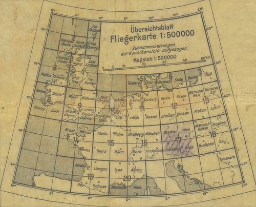
| Title | Vogels Karte von Mitteleuropa. Übersichtsblatt Fliegerkarte. |
| Main title | Közép-Európa áttekintő térképe. |