361. Ivanda ein Razisches Dorf in Czahowaer District ... [S 1 - No. 237.]
National Archives of Hungary •
S 1 Térképek (1769-1857)
•
S Königliche kameralische Mappirungs-Direction (1750-1871)
•
S – Térképtár
| Main title | Ivanda ein Razisches Dorf in Czahowaer District ... |
| Subject | No. 237. Ivánd (Torontál m., ma Ivanda, RO) |
362. No. 237:1. Ivánd (Torontál m., ma Ivanda, RO) [S 1 - No. 237:1.]
National Archives of Hungary •
S 1 Térképek (1769-1857)
•
S Königliche kameralische Mappirungs-Direction (1750-1871)
•
S – Térképtár
| Subject | No. 237:1. Ivánd (Torontál m., ma Ivanda, RO) |
363. Ivanda ein Raitzisches Dorf in Csakovar District. ... [S 1 - No. 237:2.]
National Archives of Hungary •
S 1 Térképek (1769-1857)
•
S Königliche kameralische Mappirungs-Direction (1750-1871)
•
S – Térképtár
| Main title | Ivanda ein Raitzisches Dorf in Csakovar District. ... |
| Subject | No. 237:2. Ivánd (Torontál m., ma Ivanda, RO) |
364. Plan der Weingarten des Dorfes Ivanda [S 1 - No. 237:3.]
National Archives of Hungary •
S 1 Térképek (1769-1857)
•
S Königliche kameralische Mappirungs-Direction (1750-1871)
•
S – Térképtár
| Main title | Plan der Weingarten des Dorfes Ivanda |
| Subject | No. 237:3. Ivánd (Torontál m., ma Ivanda, RO) |
365. Plan der Weingarten des Dorfes Ivanda [S 1 - No. 237:4.]
National Archives of Hungary •
S 1 Térképek (1769-1857)
•
S Königliche kameralische Mappirungs-Direction (1750-1871)
•
S – Térképtár
| Main title | Plan der Weingarten des Dorfes Ivanda |
| Subject | No. 237:4. Ivánd (Torontál m., ma Ivanda, RO) |
366. Iaas copir. Einth. Plan. [hátoldalon] [S 1 - No. 239.]
National Archives of Hungary •
S 1 Térképek (1769-1857)
•
S Königliche kameralische Mappirungs-Direction (1750-1871)
•
S – Térképtár
| Main title | Iaas copir. Einth. Plan. [hátoldalon] |
| Subject | No. 239. Jász (Krassó-Szörény m., ma Iaz, RO) |
367. Plan von dem Gehege in dem Temeswarer Districit [S 1 - No. 242.]
National Archives of Hungary •
S 1 Térképek (1769-1857)
•
S Königliche kameralische Mappirungs-Direction (1750-1871)
•
S – Térképtár
| Main title | Plan von dem Gehege in dem Temeswarer Districit |
| Subject | No. 242. Temesvár (ma Timişoara, RO) külterületén fekvő elkülönített erdő |
368. Plan deß Generalat Gebäudes eine stracke Viertel Stund von T... [S 1 - No. 242:1.]
National Archives of Hungary •
S 1 Térképek (1769-1857)
•
S Königliche kameralische Mappirungs-Direction (1750-1871)
•
S – Térképtár
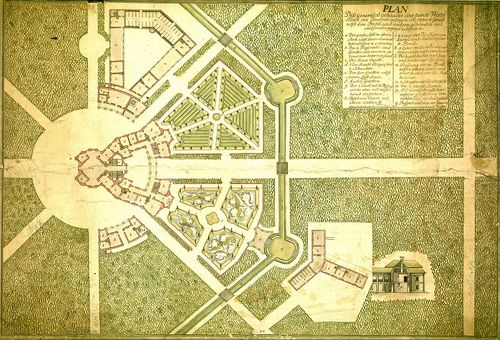
| Main title | Plan deß Generalat Gebäudes eine stracke Viertel Stund von Temesvar entlegen wie solches in Grund nebst dem Profil und andern Gebauden mit anligender Gegend zubesechen |
| Subject | No. 242:1. Temesvár (ma Timişoara, RO) külterületén lévő főhadparancsnoksági épületek és környékük |
369. No. 242:2. Temesvár (ma Timişoara, RO) külterületén fekvő fő... [S 1 - No. 242:2.]
National Archives of Hungary •
S 1 Térképek (1769-1857)
•
S Königliche kameralische Mappirungs-Direction (1750-1871)
•
S – Térképtár
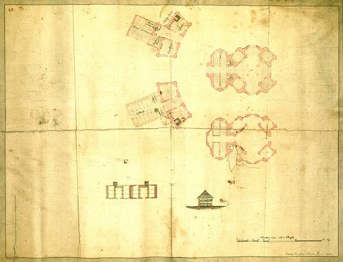
| Subject | No. 242:2. Temesvár (ma Timişoara, RO) külterületén fekvő főhadparancsnoksághoz tartozó egyes épületek |
370. Grund Riss von dem Predio Kenteresch ... [S 1 - No. 245.]
National Archives of Hungary •
S 1 Térképek (1769-1857)
•
S Königliche kameralische Mappirungs-Direction (1750-1871)
•
S – Térképtár
| Main title | Grund Riss von dem Predio Kenteresch ... |
| Subject | No. 245. Kenteresch Predium mezőgazdasági térképe |
371. Plan vom Praedium Kenderes et Vida ... [S 1 - No. 245:1.]
National Archives of Hungary •
S 1 Térképek (1769-1857)
•
S Königliche kameralische Mappirungs-Direction (1750-1871)
•
S – Térképtár
| Main title | Plan vom Praedium Kenderes et Vida ... |
| Subject | No. 245:1. Kenderes és Vida praediumok mezőgazdasági térképe |
372. Plan Berechnung von dem Praedio Kenderesch zum Beckereker Re... [S 1 - No. 245:2.]
National Archives of Hungary •
S 1 Térképek (1769-1857)
•
S Königliche kameralische Mappirungs-Direction (1750-1871)
•
S – Térképtár
| Main title | Plan Berechnung von dem Praedio Kenderesch zum Beckereker Rentamt des Torontaler Comitats Gehöring ... |
| Subject | No. 245:2. Kenderes praedium (Torontál m.) mezőgazdasági térképe |
373. Kenderesch Praedium orig. Pl . [hátoldalon] [S 1 - No. 245:3.]
National Archives of Hungary •
S 1 Térképek (1769-1857)
•
S Königliche kameralische Mappirungs-Direction (1750-1871)
•
S – Térképtár
| Main title | Kenderesch Praedium orig. Pl . [hátoldalon] |
| Subject | No. 245:3. Kenderesch praedium mezőgazdasági térképe |
374. Metal Plan des K. K. Pr. Kenderesch [S 1 - No. 245:4.]
National Archives of Hungary •
S 1 Térképek (1769-1857)
•
S Königliche kameralische Mappirungs-Direction (1750-1871)
•
S – Térképtár
| Main title | Metal Plan des K. K. Pr. Kenderesch |
| Subject | No. 245:4. Kenderesch praedium mezőgazdasági térképe; Ernestháza kül- és belterületének térképe |
375. Plan von dem in Jahre 1856 vermessenen, zu dem Itteber k. k.... [S 1 - No. 245:5.]
National Archives of Hungary •
S 1 Térképek (1769-1857)
•
S Königliche kameralische Mappirungs-Direction (1750-1871)
•
S – Térképtár
| Main title | Plan von dem in Jahre 1856 vermessenen, zu dem Itteber k. k. Fiscalitats Verwalteramte geherigen Praedien Kenderes et Vida |
| Subject | No. 245:5. Kenderes és Vida praediumok mezőgazdasági térképe |
376. Plan von den in Jahre 1856 vermeszenen zu dem Itteber K. K. ... [S 1 - No. 245:6.]
National Archives of Hungary •
S 1 Térképek (1769-1857)
•
S Königliche kameralische Mappirungs-Direction (1750-1871)
•
S – Térképtár
| Main title | Plan von den in Jahre 1856 vermeszenen zu dem Itteber K. K. Fiscalitaets Verwalteramte geherigen praedium Kenderes et Vida |
| Subject | No. 245:6. Kenderes és Vida praediumok mezőgazdasági térképe |
377. No. 246. Kallacsa mezőgazdasági és úrbéri térképe [S 1 - No. 246.]
National Archives of Hungary •
S 1 Térképek (1769-1857)
•
S Königliche kameralische Mappirungs-Direction (1750-1871)
•
S – Térképtár
| Subject | No. 246. Kallacsa mezőgazdasági és úrbéri térképe |
378. No. 246:1. Kallacsa mezőgazdasági és úrbéri térképe [S 1 - No. 246:1.]
National Archives of Hungary •
S 1 Térképek (1769-1857)
•
S Königliche kameralische Mappirungs-Direction (1750-1871)
•
S – Térképtár
| Subject | No. 246:1. Kallacsa mezőgazdasági és úrbéri térképe |
379. Kalacsa Copie [hátoldalon] [S 1 - No. 246:2.]
National Archives of Hungary •
S 1 Térképek (1769-1857)
•
S Königliche kameralische Mappirungs-Direction (1750-1871)
•
S – Térképtár
| Main title | Kalacsa Copie [hátoldalon] |
| Subject | No. 246:2. Kalacsa mezőgazdasági és úrbéri térképe |
380. No. 246:3. Kallacsa mezőgazdasági és úrbéri térképe [S 1 - No. 246:3.]
National Archives of Hungary •
S 1 Térképek (1769-1857)
•
S Königliche kameralische Mappirungs-Direction (1750-1871)
•
S – Térképtár
| Subject | No. 246:3. Kallacsa mezőgazdasági és úrbéri térképe |