1. Polska Południowo-Wschodnia / Polen Südost. [B XI c 356]
Institute and Museum of Military History •
B XI c
•
B XI Oroszország
•
B I–XV. Európa
| Title | Polska Południowo-Wschodnia / Polen Südost. |
2. Polen. [B XI a 69]
Institute and Museum of Military History •
B XI a
•
B XI Oroszország
•
B I–XV. Európa
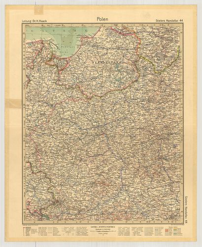
| Title | Polen. |
| Main title | Lengyelország térképe 1931-ben. |
3. [Al]lgemeiner [franzősic]her Kriegsschauplatz welcher [Frank... [S 11 - No. 777.]
National Archives of Hungary •
S 11 Kamarai térképek (1747-1882)
•
S Kormányhatósági fondokból kiemelt térképek (17. sz.-20. sz.)
•
S – Térképtár
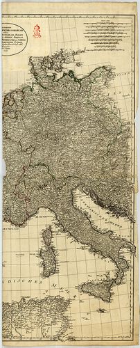
| Main title | [Al]lgemeiner [franzősic]her Kriegsschauplatz welcher [Frankreich,] Deutschland, Italien [Grossbritanie]n, Spanien, Portugal [die sämtlichen] Niederlande, die Schweiz... enthält |
| Subject | No. 777. Közép-Európai háborús hadszíntér országainak haditérképe a francia forradalom idején |
Content: [...] Schweiz Deutschland Ungarn Niederland Denemark Polen Németország Itália Cseh és Morvaország [...] Content: [...] Schweiz Deutschland Ungarn Niederland Denemark Polen Németország Itália Cseh és Morvaország [...]
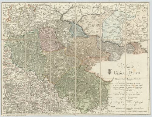
4. Polen. (Rzeczpospolita Polska) Flemmings Generalkarte. Nr. 3... [B XI a 68]
Institute and Museum of Military History •
B XI a
•
B XI Oroszország
•
B I–XV. Európa
| Title | Polen. (Rzeczpospolita Polska) Flemmings Generalkarte. Nr. 33. |
| Main title | 11 mt.: 1. (5) Reisewege von und nach Polen. (Vasút, repülő-hajózási útvonalak Európa területén.) 2. (6) Polen. (Lengyelország hegyvízrajzi térképe.) 3. (7) Warschau und Umgebung (Warszawa és környéke.) 4. (9) Das oberschlesische Kohlen- und Industriegebiet (Felső-Szilézia kőszén és iparvidéke.) 5. Oberschles. Steinkohlengebiet. (Felső-Szilézia kőszénvidéke.) 6. (10) Niederschläge (Az évi csapadék.) 7. (11) Január-Isothermen (Januári izotermák.) 8. (12) Juli-Isothermen (Júliusi izotermák.) 9. (13) Zur Geschichte Polens I. (Lengyelország 992–1025.) 10. (14) Zur Geschichte Polens II. (Lengyelország 1586.) 11. (15) Zur Geschichte Polen III. (Lengyelország 1772., 1793., 1795. évi felosztása.) |
| Subject | Lengyelország térképe 1922-ben. |
5. Karte von Polen. [B XI a 73/1]
Institute and Museum of Military History •
B XI a
•
B XI Oroszország
•
B I–XV. Európa
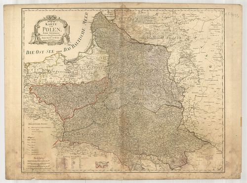
| Title | Karte von Polen. |
| Main title | Lengyelország térképe 1796-ban. |
6. Polen Westrussland bis zum Dniepr die Ostseeprovinzen und di... [B XI a 44/1]
Institute and Museum of Military History •
B XI a
•
B XI Oroszország
•
B I–XV. Európa
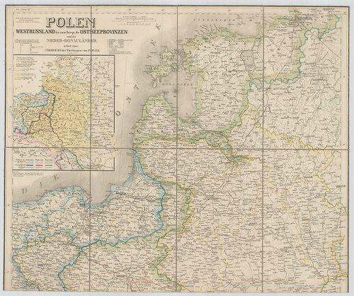
| Title | Polen Westrussland bis zum Dniepr die Ostseeprovinzen und die Nieder-Donauländer. |
| Main title | Mt.: Übersicht der Theilungen von Polen. (Áttekintő Lengyelország három felosztásáról.) |
| Subject | Lengyelország, Nyugat-Oroszország és a Keleti-tenger tartományai és a Duna alsó folyása menti országok átlalános térképe 1859-ben. |
7. Karte von Polen… 1795. [B XI a 73]
Institute and Museum of Military History •
B XI a
•
B XI Oroszország
•
B I–XV. Európa
| Title | Karte von Polen… 1795. |
| Main title | Lengyelország térképe 1795-ben. |
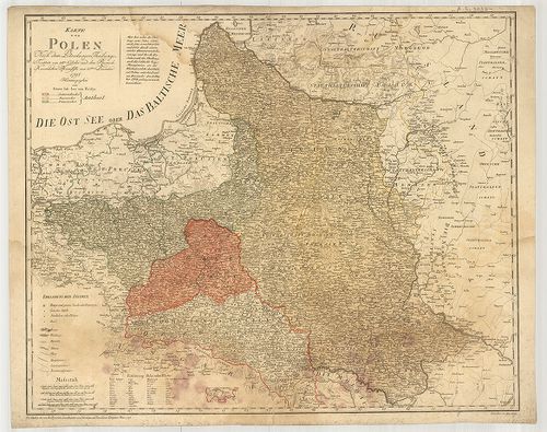
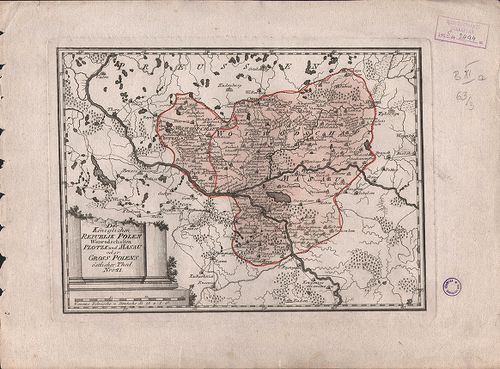
8. Karte von Gross Polen… [B XI a 65]
Institute and Museum of Military History •
B XI a
•
B XI Oroszország
•
B I–XV. Európa
| Title | Karte von Gross Polen… |
| Main title | Lengyelország térképe 1791-ben. |
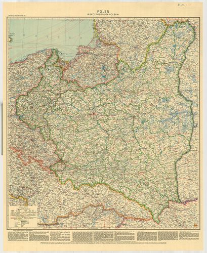
9. Polen. Politische karte. [B XI a 212]
Institute and Museum of Military History •
B XI a
•
B XI Oroszország
•
B I–XV. Európa
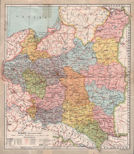
| Title | Polen. Politische karte. |
| Main title | Lengyelország közigazgatási térképe 1930 körül. |
10. Polen. Freytag und Berndt: Handkarten. [B XI a 208]
Institute and Museum of Military History •
B XI a
•
B XI Oroszország
•
B I–XV. Európa
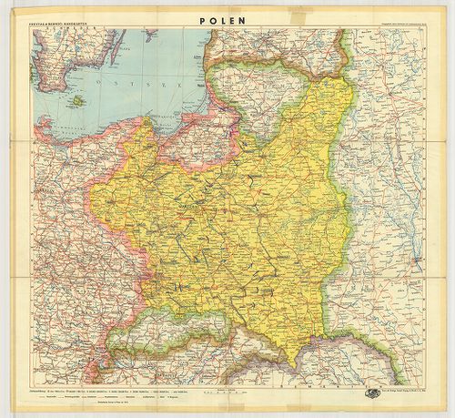
| Title | Polen. Freytag und Berndt: Handkarten. |
| Main title | Lengyelország politikai térképe 1939-ben. |
11. Karte des Königreiches Polen. [B XI a 84]
Institute and Museum of Military History •
B XI a
•
B XI Oroszország
•
B I–XV. Európa
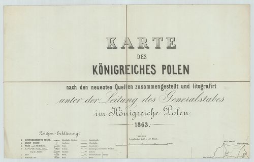
| Title | Karte des Königreiches Polen. |
| Main title | A Lengyel Királyság térképe 1863-ban. |
12. Charte von Polen. [B XI a 79]
Institute and Museum of Military History •
B XI a
•
B XI Oroszország
•
B I–XV. Európa
| Title | Charte von Polen. |
| Main title | Lengyelország térképe 1831-ben a harmadik felosztás határaival. |
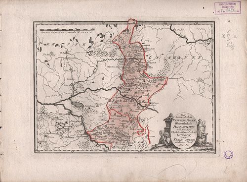
13. Der Königlichen Republik Polen. Woiwodschaft Kiew. Nro. 46. [B XI a 63/8]
Institute and Museum of Military History •
B XI a
•
B XI Oroszország
•
B I–XV. Európa
| Title | Der Königlichen Republik Polen. Woiwodschaft Kiew. Nro. 46. |
| Main title | Lengyelország Kijevi vajdasága 1789-ben. |
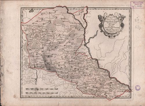
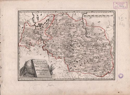
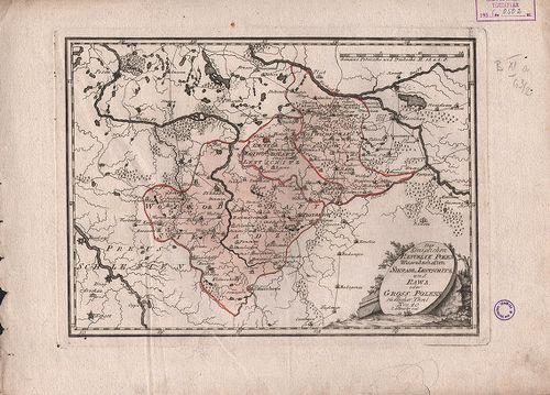
14. Der Königlichen Republik Polen Woiwodschaft Podlachien mit… ... [B XI a 63/5]
Institute and Museum of Military History •
B XI a
•
B XI Oroszország
•
B I–XV. Európa
| Title | Der Königlichen Republik Polen Woiwodschaft Podlachien mit… Lublin. Nro. 43. |
| Main title | Lengyelország vajdaságai 1789-ben. |
15. Polen Zu der Erdbeschreibung von Dittenberger No XI. [S 68 - IX. - No. 32/9.]
National Archives of Hungary •
S 68 Festetics család (1645-1943)
•
S Családi fondokból kiemelt térképek (17. sz.-20. sz.)
•
S – Térképtár
| Main title | Polen Zu der Erdbeschreibung von Dittenberger No XI. |
| Subject | IX. - No. 32/9. Lengyelország |
16. Reliefkarte von Galizien und Süd-Polen. [B XI a 164/3]
Institute and Museum of Military History •
B XI a
•
B XI Oroszország
•
B I–XV. Európa
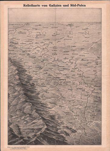
| Title | Reliefkarte von Galizien und Süd-Polen. |
| Main title | Galícia és Dél-Lengyelország madártávlatos térképe 1914-ben. |
17. Polen. [B XI a 95/3]
Institute and Museum of Military History •
B XI a
•
B XI Oroszország
•
B I–XV. Európa
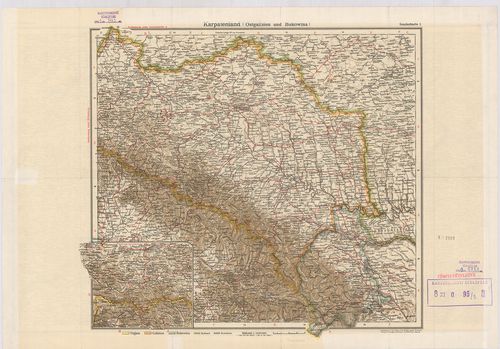
| Title | Polen. |
| Main title | Karpatenland (Ostgalizien und Bukovina.) (Kelet-Galícia és Bukovina). |
| Subject | Lengyelország térképe 1900 körül. |
18. Der Königlichen Republik Polen. Woiwodschaften Chelm und Wol... [B XI a 63/6]
Institute and Museum of Military History •
B XI a
•
B XI Oroszország
•
B I–XV. Európa
| Title | Der Königlichen Republik Polen. Woiwodschaften Chelm und Wolhynien. Nro. 44. |
| Main title | Lengyelország vajdaságai 1789-ben. |
19. Der Königlichen Republik Polen Woiwodschaften Plotzk und Mas... [B XI a 63/3]
Institute and Museum of Military History •
B XI a
•
B XI Oroszország
•
B I–XV. Európa
| Title | Der Königlichen Republik Polen Woiwodschaften Plotzk und Masau. Nro. 41. |
| Main title | Lengyelország vajdaságai 1789-ben. |
20. Der Königlichen Republik Polen Woiwodschaften Sieradz, Lents... [B XI a 63/2]
Institute and Museum of Military History •
B XI a
•
B XI Oroszország
•
B I–XV. Európa
| Title | Der Königlichen Republik Polen Woiwodschaften Sieradz, Lentschitz und Rawa. Nro. 40. |
| Main title | Lengyelország vajdaságai 1789-ben. |