3521. Entwurf eines Gartens an der Mittags-Seite des Schlosses Csa... [S 68 - No. 191.]
National Archives of Hungary •
S 68 Festetics család (1645-1943)
•
S Családi fondokból kiemelt térképek (17. sz.-20. sz.)
•
S – Térképtár
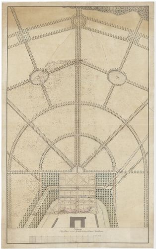
| Main title | Entwurf eines Gartens an der Mittags-Seite des Schlosses Csakathurn |
| Subject | No. 191. Csáktornya (Zala m., ma Čakovec, HR). Festetics-kastély parkja |
3522. Maedeler Gabel [Topographischer Atlas vom Königreiche Baiern... [S 68 - Nyomtatott térképsorozatok. - No. 1.]
National Archives of Hungary •
S 68 Festetics család (1645-1943)
•
S Családi fondokból kiemelt térképek (17. sz.-20. sz.)
•
S – Térképtár
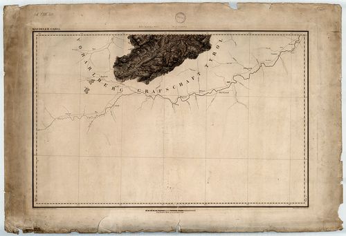
| Main title | Maedeler Gabel [Topographischer Atlas vom Königreiche Baiern 1:50 000] |
| Subject | Nyomtatott térképsorozatok. - No. 1. Mädelgabel (hegy, Allgäui-Alpok, D) és környéke |
Contributor: Topographisches Bureau des Königl Bayer Generalstabes Technical features: [...] und herausgegeben vom Topographischen Bureau des Königl Bayer Generalstabes 1 50 [...]
3523. Lindau [Topographischer Atlas vom Königreiche Baiern 1:50 00... [S 68 - Nyomtatott térképsorozatok. - No. 2.]
National Archives of Hungary •
S 68 Festetics család (1645-1943)
•
S Családi fondokból kiemelt térképek (17. sz.-20. sz.)
•
S – Térképtár

| Main title | Lindau [Topographischer Atlas vom Königreiche Baiern 1:50 000] |
| Subject | Nyomtatott térképsorozatok. - No. 2. Lindau (D) és környéke |
Contributor: Topographisches Bureau des Königl Bayer Generalstabes Technical features: [...] und herausgegeben vom Topographischen Bureau des Königl Bayer Generalstabes 1 50 [...]
3524. Finsterau [Topographischer Atlas vom Königreiche Baiern 1:50... [S 68 - Nyomtatott térképsorozatok. - No. 3.]
National Archives of Hungary •
S 68 Festetics család (1645-1943)
•
S Családi fondokból kiemelt térképek (17. sz.-20. sz.)
•
S – Térképtár

| Main title | Finsterau [Topographischer Atlas vom Königreiche Baiern 1:50 000] |
| Subject | Nyomtatott térképsorozatok. - No. 3. Finsterau (D) és környéke |
Contributor: Topographisches Bureau des Königl Bayer Generalstabes Technical features: [...] und herausgegeben vom Topographischen Bureau des Königl Bayer Generalstabes 1 50 [...]
3525. Reichenhall [Topographischer Atlas vom Königreiche Baiern 1:... [S 68 - Nyomtatott térképsorozatok. - No. 4.]
National Archives of Hungary •
S 68 Festetics család (1645-1943)
•
S Családi fondokból kiemelt térképek (17. sz.-20. sz.)
•
S – Térképtár
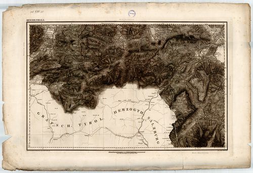
| Main title | Reichenhall [Topographischer Atlas vom Königreiche Baiern 1:50 000] |
| Subject | Nyomtatott térképsorozatok. - No. 4. Bad Reichenhall (D) és környéke |
Contributor: Topographisches Bureau des Königl Bayer Generalstabes Technical features: [...] und herausgegeben vom Topographischen Bureau des Königl Bayer Generalstabes 1 50 [...]
3526. St. Bartholomae [Topographischer Atlas vom Königreiche Baier... [S 68 - Nyomtatott térképsorozatok. - No. 5.]
National Archives of Hungary •
S 68 Festetics család (1645-1943)
•
S Családi fondokból kiemelt térképek (17. sz.-20. sz.)
•
S – Térképtár

| Main title | St. Bartholomae [Topographischer Atlas vom Königreiche Baiern 1:50 000] |
| Subject | Nyomtatott térképsorozatok. - No. 5. Schönau am Königssee (D) környéke |
Contributor: Topographisches Bureau des Königl Bayer Generalstabes Technical features: [...] und herausgegeben vom Topographischen Bureau des Königl Bayer Generalstabes 1 50 [...]
3527. Berchtesgaden [Topographischer Atlas vom Königreiche Baiern ... [S 68 - Nyomtatott térképsorozatok. - No. 6.]
National Archives of Hungary •
S 68 Festetics család (1645-1943)
•
S Családi fondokból kiemelt térképek (17. sz.-20. sz.)
•
S – Térképtár

| Main title | Berchtesgaden [Topographischer Atlas vom Königreiche Baiern 1:50 000] |
| Subject | Nyomtatott térképsorozatok. - No. 6. Berchtesgaden (D) és környéke |
Contributor: Topographisches Bureau des Königl Bayer Generalstabes Technical features: [...] und herausgegeben vom Topographischen Bureau des Königl Bayer Generalstabes 1 50 [...]
3528. Traunstein [Topographischer Atlas vom Königreiche Baiern 1:5... [S 68 - Nyomtatott térképsorozatok. - No. 7.]
National Archives of Hungary •
S 68 Festetics család (1645-1943)
•
S Családi fondokból kiemelt térképek (17. sz.-20. sz.)
•
S – Térképtár

| Main title | Traunstein [Topographischer Atlas vom Königreiche Baiern 1:50 000] |
| Subject | Nyomtatott térképsorozatok. - No. 7. Traunstein (D) és környéke |
Contributor: Topographisches Bureau des Königl Bayer Generalstabes Technical features: [...] und herausgegeben vom Topographischen Bureau des Königl Bayer Generalstabes 1 50 [...]
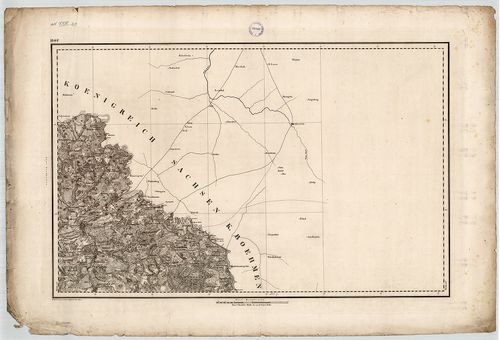
3529. Salzburghofen [Topographischer Atlas vom Königreiche Baiern ... [S 68 - Nyomtatott térképsorozatok. - No. 8.]
National Archives of Hungary •
S 68 Festetics család (1645-1943)
•
S Családi fondokból kiemelt térképek (17. sz.-20. sz.)
•
S – Térképtár

| Main title | Salzburghofen [Topographischer Atlas vom Königreiche Baiern 1:50 000] |
| Subject | Nyomtatott térképsorozatok. - No. 8. Salzburghofen (ma Freilassing, D) és környéke |
Contributor: Topographisches Bureau des Königl Bayer Generalstabes Technical features: [...] und herausgegeben vom Topographischen Bureau des Königl Bayer Generalstabes 1 50 [...]
3530. Illertissen [Topographischer Atlas vom Königreiche Baiern 1:... [S 68 - Nyomtatott térképsorozatok. - No. 9.]
National Archives of Hungary •
S 68 Festetics család (1645-1943)
•
S Családi fondokból kiemelt térképek (17. sz.-20. sz.)
•
S – Térképtár

| Main title | Illertissen [Topographischer Atlas vom Königreiche Baiern 1:50 000] |
| Subject | Nyomtatott térképsorozatok. - No. 9. Illertissen (D) és környéke |
Contributor: Topographisches Bureau des Königl Bayer Generalstabes Technical features: [...] und herausgegeben vom Topographischen Bureau des Königl Bayer Generalstabes 1 50 [...]
3531. Lauenstein [Topographischer Atlas vom Königreiche Baiern 1:5... [S 68 - Nyomtatott térképsorozatok. - No. 10.]
National Archives of Hungary •
S 68 Festetics család (1645-1943)
•
S Családi fondokból kiemelt térképek (17. sz.-20. sz.)
•
S – Térképtár

| Main title | Lauenstein [Topographischer Atlas vom Königreiche Baiern 1:50 000] |
| Subject | Nyomtatott térképsorozatok. - No. 10. Lauenstein (ma Ludwigsstadt, D) és környéke |
Contributor: Topographisches Bureau des Königl Bayer Generalstabes Technical features: [...] und herausgegeben vom Topographischen Bureau des Königl Bayer Generalstabes 1 50 [...]
3532. Hof [Topographischer Atlas vom Königreiche Baiern 1:50 000] [S 68 - Nyomtatott térképsorozatok. - No. 11.]
National Archives of Hungary •
S 68 Festetics család (1645-1943)
•
S Családi fondokból kiemelt térképek (17. sz.-20. sz.)
•
S – Térképtár
| Main title | Hof [Topographischer Atlas vom Königreiche Baiern 1:50 000] |
| Subject | Nyomtatott térképsorozatok. - No. 11. Hof (D) és környéke |
Contributor: Topographisches Bureau des Königl Bayer Generalstabes Technical features: [...] und herausgegeben vom Topographischen Bureau des Königl Bayer Generalstabes 1 50 [...]
3533. Mindelheim [Topographischer Atlas vom Königreiche Baiern 1:5... [S 68 - Nyomtatott térképsorozatok. - No. 12.]
National Archives of Hungary •
S 68 Festetics család (1645-1943)
•
S Családi fondokból kiemelt térképek (17. sz.-20. sz.)
•
S – Térképtár
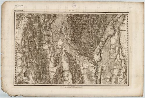
| Main title | Mindelheim [Topographischer Atlas vom Königreiche Baiern 1:50 000] |
| Subject | Nyomtatott térképsorozatok. - No. 12. Mindelheim (D) és környéke |
Contributor: Topographisches Bureau des Königl Bayer Generalstabes Technical features: [...] und herausgegeben vom Topographischen Bureau des Königl Bayer Generalstabes 1 50 [...]
3534. Elchingen [Topographischer Atlas vom Königreiche Baiern 1:50... [S 68 - Nyomtatott térképsorozatok. - No. 13.]
National Archives of Hungary •
S 68 Festetics család (1645-1943)
•
S Családi fondokból kiemelt térképek (17. sz.-20. sz.)
•
S – Térképtár

| Main title | Elchingen [Topographischer Atlas vom Königreiche Baiern 1:50 000] |
| Subject | Nyomtatott térképsorozatok. - No. 13. Elchingen (D) és környéke |
Contributor: Topographisches Bureau des Königl Bayer Generalstabes Technical features: [...] und herausgegeben vom Topographischen Bureau des Königl Bayer Generalstabes 1 50 [...]
3535. Tirschenreut [Topographischer Atlas vom Königreiche Baiern 1... [S 68 - Nyomtatott térképsorozatok. - No. 14.]
National Archives of Hungary •
S 68 Festetics család (1645-1943)
•
S Családi fondokból kiemelt térképek (17. sz.-20. sz.)
•
S – Térképtár

| Main title | Tirschenreut [Topographischer Atlas vom Königreiche Baiern 1:50 000] |
| Subject | Nyomtatott térképsorozatok. - No. 14. Tirschenreuth (D) és környéke |
Contributor: Topographisches Bureau des Königl Bayer Generalstabes Technical features: [...] und herausgegeben vom Topographischen Bureau des Königl Bayer Generalstabes 1 50 [...]
3536. Pegnitz [Topographischer Atlas vom Königreiche Baiern 1:50 0... [S 68 - Nyomtatott térképsorozatok. - No. 15.]
National Archives of Hungary •
S 68 Festetics család (1645-1943)
•
S Családi fondokból kiemelt térképek (17. sz.-20. sz.)
•
S – Térképtár

| Main title | Pegnitz [Topographischer Atlas vom Königreiche Baiern 1:50 000] |
| Subject | Nyomtatott térképsorozatok. - No. 15. Pegnitz (D) és környéke |
Contributor: Topographisches Bureau des Königl Bayer Generalstabes Technical features: [...] und herausgegeben vom Topographischen Bureau des Königl Bayer Generalstabes 1 50 [...]
3537. Carte générale du théatre de la guerre en Italie et dans les... [S 68 - Nyomtatott térképsorozatok. - No. 16-46.]
National Archives of Hungary •
S 68 Festetics család (1645-1943)
•
S Családi fondokból kiemelt térképek (17. sz.-20. sz.)
•
S – Térképtár
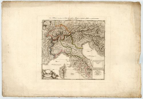
| Main title | Carte générale du théatre de la guerre en Italie et dans les Alpes depuis le passage du Var le 29 7-bre 1792 V. S. jusqu' a l'entrée des francais a Rome le 22 pluviose an 6-me Re. pain avec les limites et divisions des nouvelles Républiques |
| Subject | Nyomtatott térképsorozatok. - No. 16-46. Észak-Itália a napóleoni háborúk idején |
3538. Carte générale des royaumes de Naples, Sicile et Sardaigne a... [S 68 - Nyomtatott térképsorozatok. - No. 47-66.]
National Archives of Hungary •
S 68 Festetics család (1645-1943)
•
S Családi fondokból kiemelt térképek (17. sz.-20. sz.)
•
S – Térképtár

| Main title | Carte générale des royaumes de Naples, Sicile et Sardaigne ainsi que des isles de Malte et de Goze, formant la Seconde partie de la Carte g. le du théâtre de la guerre en Italie dans les Alpes ... XXIV feuilles |
| Subject | Nyomtatott térképsorozatok. - No. 47-66. Dél-Itália a napóleoni háborúk idején |
Content: [...] guerre en Italie Cannevas général des deux parties de la Carte [...]
3539. Geognostische Karte des Oesterreichischen Kaiserstaates mit ... [S 68 - Vegyes nyomtatott térképek. - No. 1.]
National Archives of Hungary •
S 68 Festetics család (1645-1943)
•
S Családi fondokból kiemelt térképek (17. sz.-20. sz.)
•
S – Térképtár

| Main title | Geognostische Karte des Oesterreichischen Kaiserstaates mit einem grossen Theile Deutschland's u. Italien |
| Subject | Vegyes nyomtatott térképek. - No. 1. Osztrák Császárság, Magyarország |
3540. Uibersichts-Karte zu dem Vorschlag in Betreff der Regulation... [S 68 - Vegyes nyomtatott térképek. - No. 5.]
National Archives of Hungary •
S 68 Festetics család (1645-1943)
•
S Családi fondokból kiemelt térképek (17. sz.-20. sz.)
•
S – Térképtár

| Main title | Uibersichts-Karte zu dem Vorschlag in Betreff der Regulation des ungarischen Communicationswesens (vom Grafen Stefan Széchenyi) |
| Subject | Vegyes nyomtatott térképek. - No. 5. Magyarország |