741. Azonosítatlan szerkezeti tervek, tetők, felülvilágítók. Öntö... [HU BFL - XV.17.f.331.b - a28/3]
Budapest City Archives •
HU BFL XV.17.f.331.b Ybl Miklós hagyatéka, tervek (1844-1891)
•
HU BFL XV.17.f.331 Ybl Miklós hagyatéka, tervek és iratok (1844-1891)
•
HU BFL XV.17.f Építészek, vállalkozók, vállalatok, beruházók tervei (1844-2005)
•
HU BFL XV.17 - Tervtár
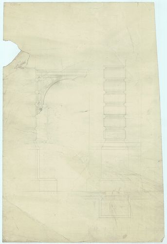
| Subject | Azonosítatlan szerkezeti tervek, tetők, felülvilágítók. Öntöttvas bejárati előtető-konzol oldalnézete. |
Content: Construction des eisernen Balkons in Naturgrösse
742. Azonosítatlan portáltervek. Kávéházi portál előtti összecsuk... [HU BFL - XV.17.f.331.b - a40/5]
Budapest City Archives •
HU BFL XV.17.f.331.b Ybl Miklós hagyatéka, tervek (1844-1891)
•
HU BFL XV.17.f.331 Ybl Miklós hagyatéka, tervek és iratok (1844-1891)
•
HU BFL XV.17.f Építészek, vállalkozók, vállalatok, beruházók tervei (1844-2005)
•
HU BFL XV.17 - Tervtár
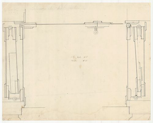
| Subject | Azonosítatlan portáltervek. Kávéházi portál előtti összecsukható fémlemez ajtó szerkezeti rajza. |
Content: Ladenverschluss des Caffehauses
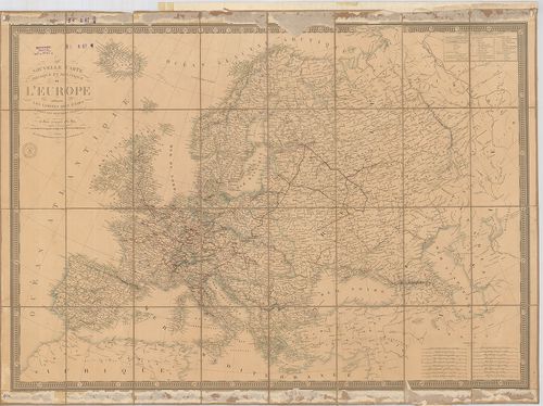
743. Nouvelle Carte Géographique et des postes de L’Europe… Neues... [B I a 6]
Institute and Museum of Military History •
B I a
•
B I Európa
•
B I–XV. Európa
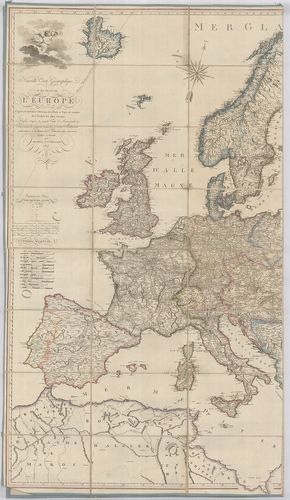
| Title | Nouvelle Carte Géographique et des postes de L’Europe… Neueste Post u. General Karte von Europa. |
| Main title | Európa földrajzi és postatérképe 1807-ben. |
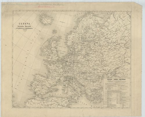
744. Europa. Politische Übersicht zu Beginn des 18-ten Jahrhunder... [B I a 14/2]
Institute and Museum of Military History •
B I a
•
B I Európa
•
B I–XV. Európa
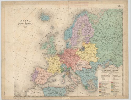
| Title | Europa. Politische Übersicht zu Beginn des 18-ten Jahrhunderts. |
| Main title | Európa áttekintő politikai térképe a XVIII. sz. elején. |
Technical features: [...] 44 cm Szín Melléklet Feldzüge des Prinzen Eugen v Savoyen 1 [...]
745. Orographische Karte von Europa, … [B I a 16/1]
Institute and Museum of Military History •
B I a
•
B I Európa
•
B I–XV. Európa
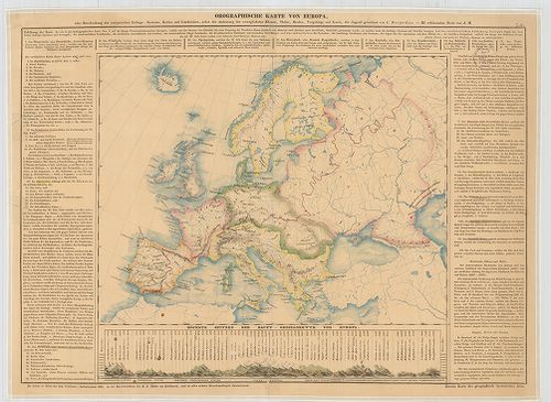
| Title | Orographische Karte von Europa, … |
| Main title | Európa hegyrajzi térképe. |
Technical features: [...] árny Szöv magy Zweite Karte des geographisch hystorischen Atlas A földrajzi [...]
746. General-Karte von Europa in 25 Blättern. [B I a 19]
Institute and Museum of Military History •
B I a
•
B I Európa
•
B I–XV. Európa
| Title | General-Karte von Europa in 25 Blättern. |
| Main title | 5 mt.: 1. Plan von London. (II/b szelv.) 2. Plan von Petersburg (V. szelv.) 3. Umgebung von Wien (VI. szelv.) 4. Plan von Neapel (XXI. szelv.) 5. Plan von München (XXII. szelv.) 6. Plan von Berlin (XXII. szelv.) A XXV/b. szelv.-en: Geognostische Karte des oesterreichischen Kaiserstaates mit einem grossen Theile Deutschland u. Italien. |
| Subject | Európa általános térképe 1845–47-ben 25 szelvényen. |
747. Carte de l’Europe. Selon les nationalités et les intéręts de... [B I a 24]
Institute and Museum of Military History •
B I a
•
B I Európa
•
B I–XV. Európa
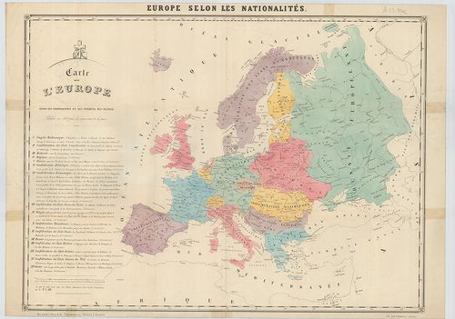
| Title | Carte de l’Europe. Selon les nationalités et les intéręts des peuples. |
| Main title | Az európai konföderáció terve. |
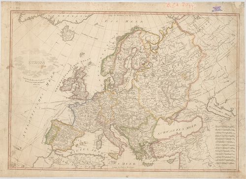
748. Nouvelle carte physique et politique de L’Europe indiquant l... [B I a 47]
Institute and Museum of Military History •
B I a
•
B I Európa
•
B I–XV. Európa
| Title | Nouvelle carte physique et politique de L’Europe indiquant les limites des états. Commencée Brué, comptetée par Picquet. |
| Main title | Európa földrajzi és politikai térképe 1844-ben |
749. Karte zur Geschichte des Mittelalters. [B I a 70/2]
Institute and Museum of Military History •
B I a
•
B I Európa
•
B I–XV. Európa
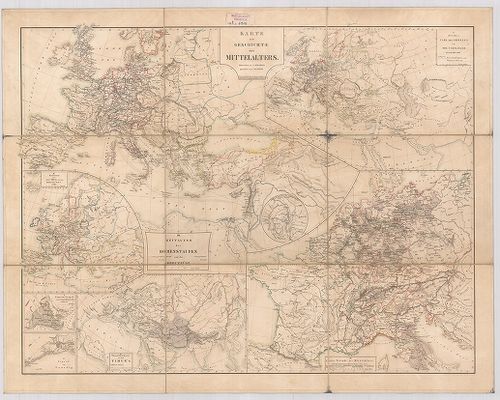
| Title | Karte zur Geschichte des Mittelalters. |
| Main title | 7 mt.: I. Zeitalter Carl des Grossen und der Carolinger bis zum Jahr 888. (Nagy Károly és a Karoling-korszak.) II. Zeitraum vom Jahre 888 bis zu den Kreuzzügen. (1096.) (888-tól a keresztes hadjáratokig) III. Zeitalter der Hohenstaufen und die Kreuzzüge. (Hohenstaufok és a keresztes hadjáratok). IV. Letzte Periode des Mittelalters. (A középkor végső szakasza.) V. Übersichts-Karte zur Zeit Timur’s. (Timur-korszak áttekintő térképe.) 2. Constatinopel, erobert durch Muhamed II, d 29. Mai. 1455. Konstantinápoly (Istanbul) meghódítása.) II. Mohamed által 1455. máj. 19-én. 3. Gegend um Venedig. (Velence környéke.) |
| Subject | A középkor történelmi térképei |
750. Europa. Samt den Reisen des Capitain Cook. Véste: Franz Reis... [B I a 70/4]
Institute and Museum of Military History •
B I a
•
B I Európa
•
B I–XV. Európa
| Title | Europa. Samt den Reisen des Capitain Cook. Véste: Franz Reisser. |
| Main title | Európa a XVIII. század második felében, Cook kapitány hajózási útvonalaival. |
751. Europa. [B I a 116]
Institute and Museum of Military History •
B I a
•
B I Európa
•
B I–XV. Európa
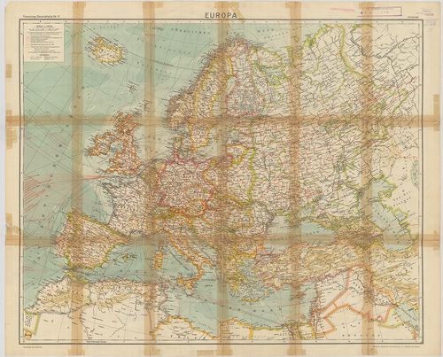
| Title | Europa. |
| Main title | 10 mt.: 1. Europa: Bodenerhabungen. (Európa talajai) 2. Europa: Pflanzengeographische Übersicht. (Európa növényföldrajzi áttekintése.) 3. Europa: Verbreitung der Religionen. (Vallások elterjedése Európában.) 4. Europa: Bodenschätze. (Európa ásványkincsei.) 5. Europa zur zeit Karls des Grossen 814 n[ach] Chr. (Európa Nagy Károly idejében, 814.) 6. Europa zur Zeit der Staufer 1138×1254. (Európa a Staufok idejében 1138–1254.) 7. Europa im XV. Jahrhundert. (Európa a XV. sz.-ban.) 8. Europa im Jahre 1815. (Európa 1815-ben.) 9. Europa 1914: Staaten und Völker. (Európa 1914: Országok és népek.) 10. Europa 1924 Staatenübersicht. (Európa országainak áttekintése 1924-ben.) |
| Subject | Európa politikai térképe 1920 körül. |
752. Europa nach dem Friedensschluss 1919. …er, 1919, der Wöchent... [B I a 117]
Institute and Museum of Military History •
B I a
•
B I Európa
•
B I–XV. Európa
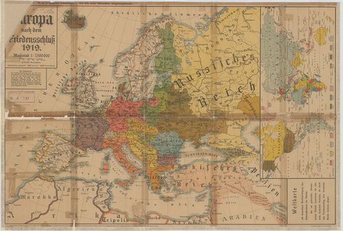
| Title | Europa nach dem Friedensschluss 1919. …er, 1919, der Wöchentlichen Völkerkriegskarten 1914–1919 vorher Wöchentliche Kriegsschauplatzkarte. |
| Main title | Mt.: Weltkarte mit besonderer Berücksichtigung des Kolonialbesitze der Mächte. (A Gyarmatosító hatalmak a Világban.) |
| Subject | Európa a békekötés után 1919-ben. |
753. Operationskarte. [B I a 175]
Institute and Museum of Military History •
B I a
•
B I Európa
•
B I–XV. Európa
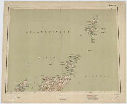
| Title | Operationskarte. |
| Main title | Európa nagy részének hadműveleti térképe. |
Technical features: [...] n 1914 1918 Kartogr Abteilung des Stellvertretenden Generalstabes des Armee
754. Karte des Baltischen Meeres und der, dassalbe begrenzenden L... [B I b 58]
Institute and Museum of Military History •
B I b
•
B I Európa
•
B I–XV. Európa
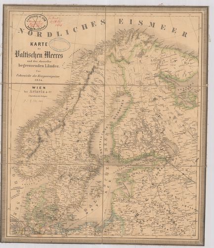
| Title | Karte des Baltischen Meeres und der, dassalbe begrenzenden Länder. Zur Uebersicht der Kriegsereignisse 1854. |
| Main title | A Balti-tenger és a vele határos országok térképe 1854-ben. |
755. Römisches Reich. [B I c 2]
Institute and Museum of Military History •
B I c
•
B I Európa
•
B I–XV. Európa
| Title | Römisches Reich. |
| Main title | Mt.: Krise und Niedergang des Röm. Reich. (III.–V. Jahrhundert.) (A Római-Birodalom hanyatlása és bukása, V.–III. században.) |
| Subject | A Római Birodalom térképe. |
756. Neueste Allgemeine Postkarte durch alle Europaeische Staaten... [B I c 8/a]
Institute and Museum of Military History •
B I c
•
B I Európa
•
B I–XV. Európa
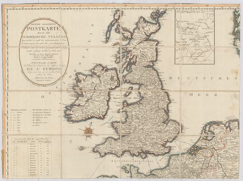
| Title | Neueste Allgemeine Postkarte durch alle Europaeische Staaten… Nouvelle Carte des Routes des Postes dans les différens États de l’Europe… Véste: Hieron. Benedicti. |
| Main title | Mt.: [Moszkva környéke] |
| Subject | Európa postaúthálózatának térképe 1798-ban. |
757. Karte des Europaeischen Telegraphen-Netzes. [B I c 12/1]
Institute and Museum of Military History •
B I c
•
B I Európa
•
B I–XV. Európa
| Title | Karte des Europaeischen Telegraphen-Netzes. |
| Main title | Európa távíróhálózatának térképe. |
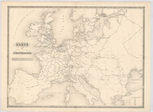
758. Eisenbahn-Post und Dampfschiffs-Karte von Europa. – Railway ... [B I c 13]
Institute and Museum of Military History •
B I c
•
B I Európa
•
B I–XV. Európa
| Title | Eisenbahn-Post und Dampfschiffs-Karte von Europa. – Railway Steam-Boat and Post Map of Europe. – Carte des Chemins de Fer voies navigables et Routes Postales de l’Europe. |
| Main title | 5 mt.: 1. Der Rhein von Mainz bis Wesel. 2. London 3. Paris. 4. Die Schweiz 5. Die belgischen Eisenbahnen. |
| Subject | Európa közlekedési térképe 1867-ben. |
759. Europa Politische Übersicht zu Beginn des 18. Jahrhunderts. [B I c 32/1]
Institute and Museum of Military History •
B I c
•
B I Európa
•
B I–XV. Európa
| Title | Europa Politische Übersicht zu Beginn des 18. Jahrhunderts. |
| Main title | Európa politikai térképe a 18. században. |
760. Carte itinéraire des voies navigables de l’Europe. [B I c 60]
Institute and Museum of Military History •
B I c
•
B I Európa
•
B I–XV. Európa
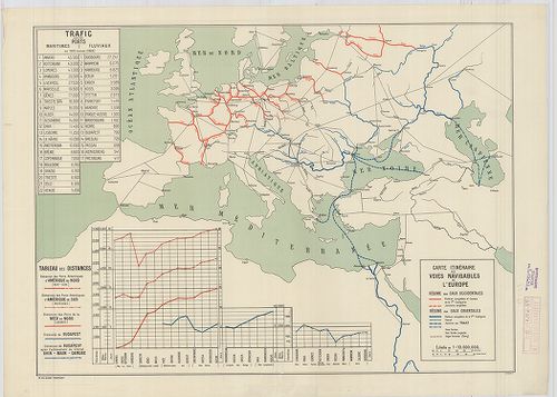
| Title | Carte itinéraire des voies navigables de l’Europe. |
| Main title | Európa légi útjainak térképe 1928. |